Report on Manda Hararo (Ethiopia) — July 2007
Bulletin of the Global Volcanism Network, vol. 32, no. 7 (July 2007)
Managing Editor: Richard Wunderman.
Manda Hararo (Ethiopia) First historical eruption?lava flows/SO2 plume from rift fissure?August 2007
Please cite this report as:
Global Volcanism Program, 2007. Report on Manda Hararo (Ethiopia) (Wunderman, R., ed.). Bulletin of the Global Volcanism Network, 32:7. Smithsonian Institution. https://doi.org/10.5479/si.GVP.BGVN200707-221115
Manda Hararo
Ethiopia
12.17°N, 40.82°E; summit elev. 600 m
All times are local (unless otherwise noted)
On 13 August at 1315 a large sulfur-dioxide (SO2) cloud was detected over Ethiopia and Sudan by the Ozone Monitoring Instrument (OMI) on NASA's Aura satellite. This was presumed to be the result of a volcanic eruption in western Afar, Ethiopia, though the source was then unclear. Preliminary analysis indicated that the cloud contained ~ 8,000 tons of SO2, although a more precise estimate depends on the altitude of the cloud, which was not known.
MODIS satellite imagery, interpreted at the University of Hawaii, showed the presence of a cluster of hot-spots centered at 12.25°N, 40.65°E late on 12 August, presumably corresponding to an active lava flow. The eruption site appears to lie within the Manda Hararo volcanic complex around 40 km SSE of Dabbahu volcano, which had its first historical eruption in September 2005. The massive 105-km-long, 20-30 km-wide Manda Hararo complex consists of basaltic shield volcanoes cut by regional fissures with no previously recorded historical eruptions. It is the southernmost axial range of the western Afar region. OMI data on 14 August showed continuing SO2 emissions, although by that day the extent of the MODIS thermal anomaly had diminished.
Local residents reported that there had been no precursory activity of any kind during the days preceding the eruptions. The first sign of activity was noted on 12 August when a sudden heavy cracking sound was heard in the affected area. The sound was heard first in the N part and propagated continuously toward the S. Only a small ground tremor was felt at that time. At about 1730 on 13 August, "fire" started to be seen from the N in the direction of Gommoyta and continued to the N, lighting up the entire area. A curtain of "fire and smoke" rose high into the sky in the area and this activity continued with variable intensity until it subsided on the morning of 16 August. The frightened local inhabitants evacuated the area and therefore did not observe effusion of the lava flows. So far no damage to life or property has been reported.
A field team was able to investigate the area of new eruptions in the Manda Hararo region on 20 August (figure 1). Karbahi is the name given to the rift's axial segment/graben, a region with numerous active normal faults, fissures, and recent basalt flows, bounded by large normal faults. Prominent features in the Karbahi graben area include Gommoyta and Diyyilu felsic volcanoes, which are found immediately to the N of this locality.
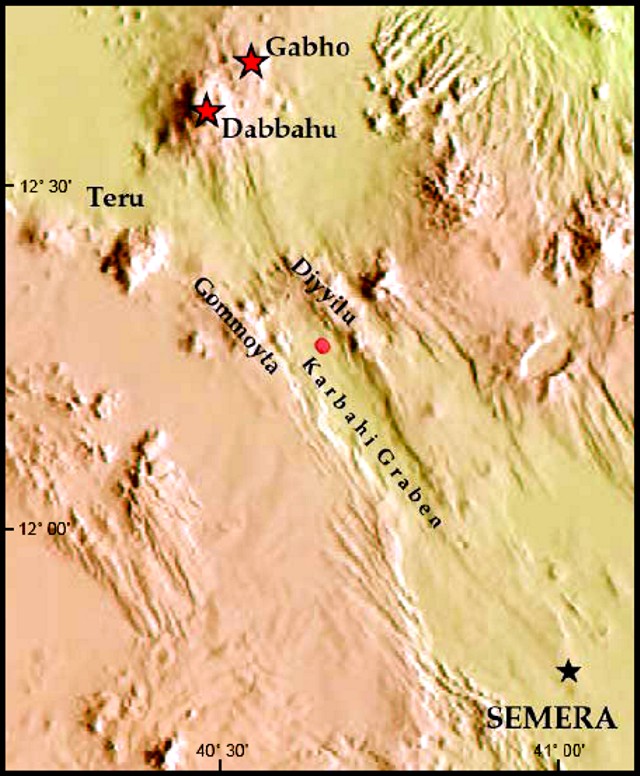 |
Figure 1. Location of the Manda Hararo fissure eruption (round dot). Other features shown include the Gabho and Dabbahu volcanoes, and the city of Semera. Courtesy of Gezahegn Yirgu, Addis Ababa University. |
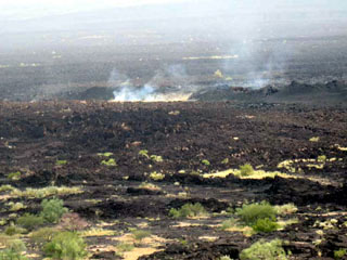
Aerial observations showed isolated spots where intense emission of gas (with distinct smell of sulfur dioxide) was taking place. In few places, white and yellowish deposits of sulfur were visible. Long, discontinuous fissures, arranged en echelon, from which lavas had flowed on either side, predominantly traveling W to the graben floor (figure 2). Numerous small spatter and scoria cones were aligned on the fissures. Reddish glow and rare flames were also observed on top of some of the tiny craters of these cones. Fault scarps with fresh breaks and rock falls were also visible from the air, probably showing evidence of recent movement. A narrow graben-like collapse structure oblique to one of the fissures was also observed. The segment affected by tectonic and volcanic activity was estimated (with the help of a helicopter pilot) to measure 5-7 km long and 1 km wide.
 |
Figure 2. Steam rises from new fissures that fed lava flows at Manda Hararo, as seen on 20 August 2007. Courtesy of Gezahegn Yirgu, Addis Ababa University. |
Ground investigations found basalt lava flows and steam emissions ongoing on 20 August. While walking on top of the lavas, scientists felt immense heat emanating from the flow surface. Each fissure was covered by a continuous row of small and closely spaced spatter and scoria cones. Many of the cones themselves had tiny pits from which both heat and gas escaped. The pits could not be entered due to the heat and high noxious gas concentrations. As seen from the air, a reddish glow and flames were seen at some distant cones. One fissure with its row of cones is oriented about N7°W to N10°W.
The observed aa and pahoehoe flows were relatively viscous and did not travel beyond a few hundred meters from their fissure vents (figure 3). The overall thickness of the flows was variable and reached several meters in places. Lava channels and tubes were abundant. The spatter ramparts and scoria cones varied in height from 2 to 10 m. Spatter and scoria fragments varied from coarse lapilli to bombs. The new lava was moderately porphyritic with small and sparse plagioclase phenocrysts. Field observations found that the older lavas at the site exhibited the same features. Representative lava samples were collected.
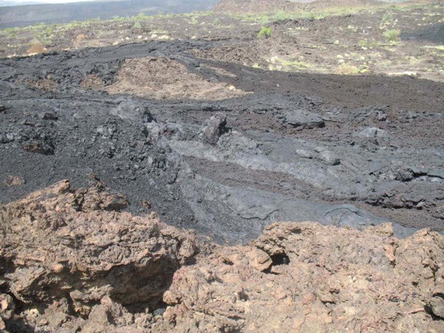 |
Figure 3. A closer view of the August 2007 lava at Manda Hararo. The dark-colored basaltic flows display aa and pahoehoe textures. Courtesy of Gezahegn Yirgu, Addis Ababa University. |
Geological Summary. As the southernmost axial range of western Afar, the Manda Hararo complex is located in the Kalo plain, SSE of Dabbahu volcano. The massive 105-km-long and 20-30 km wide complex represents an uplifted segment of a mid-ocean ridge spreading center. A small basaltic shield volcano is located at the N end of the complex, S of which is an area of abundant fissure-fed lava flows. Two basaltic shield volcanoes, the larger of which is Unda Hararo, occupy the center of the complex. The dominant Gumatmali-Gablaytu fissure system lies to the S. Voluminous fluid lava flows issued from these NNW-trending fissures, and solidified lava lakes occupy two large craters. The small Gablaytu shield volcano forms the SE-most end of the complex. Lava flows from Gablaytu and from Manda overlie 8,000-year-old sediments. Hot springs and fumaroles occur around Daorre lake. The first historical eruptions produced fissure-fed lava flows in 2007 and 2009.
Information Contacts: Gezahegn Yirgu, Atalay Ayele, Shimeles Fisseha, Tadiwos Chernet, and Ato Kifle Damtew, Department of Earth Sciences, Addis Ababa University, Addis Ababa, Ethiopia; Simon Carn, Joint Center for Earth Systems Technology (JCET), University of Maryland Baltimore County (UMBC), 1000 Hilltop Circle, Baltimore, MD 21250, USA (URL: https://so2.gsfc.nasa.gov/); Hawai'i Institute of Geophysics and Planetology (HIGP) Thermal Alerts System, School of Ocean and Earth Science and Technology (SOEST), Univ. of Hawai'i, 2525 Correa Road, Honolulu, HI 96822, USA (URL: http://modis.higp.hawaii.edu/).