Report on St. Helens (United States) — August 2007

Bulletin of the Global Volcanism Network, vol. 32, no. 8 (August 2007)
Managing Editor: Richard Wunderman.
St. Helens (United States) Dome growth continues, seismicity remains low
Please cite this report as:
Global Volcanism Program, 2007. Report on St. Helens (United States) (Wunderman, R., ed.). Bulletin of the Global Volcanism Network, 32:8. Smithsonian Institution. https://doi.org/10.5479/si.GVP.BGVN200708-321050
St. Helens
United States
46.2°N, 122.18°W; summit elev. 2549 m
All times are local (unless otherwise noted)
Lava dome growth at St. Helens (as previously reported in BGVN 31:12) continued through at least September 2007. Seismicity remained at low levels punctuated by M 1.5-2.5, and occasionally larger, earthquakes. Inclement weather inhibited field work and created poor visibility for much of the January-September reporting period.
In general, gas-and-steam plumes from the active lava dome, as well as dust plumes resulting from rockfalls, occasionally rose above the crater rim. A gas plume may have been seen on 3 June, and a weak gas-and-steam plume was visible rising from the lava dome on 12 June.
On 3 April, a GPS unit on an active spine showed W-ward movement at a rate of approximately 30 cm/day. Points on the active part of the dome moved away from the vent at an average rate of approximately 0.45m/day July 2007. That rate is similar to but slightly less than it was a year ago.
Growth of the lava dome and changes in crater morphology over the course of this eruption have been well documented (figures 69 and 70).
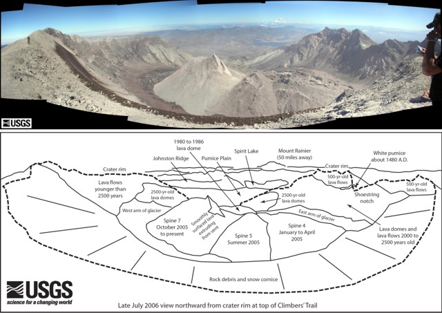 |
Figure 69. A panoramic wide-angle view from St. Helens' crater rim looking N on 27 July 2006. The accompanying sketch describes key features in the photo. For example, the dark rim wrapping around the lower margin of the photo represents rock debris on the snow cornice. Courtesy of Willie Scott, USGS Cascades Volcano Observatory. |
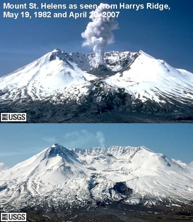 |
Figure 70. Comparison photo taken of Mount St. Helens as seen from Harrys Ridge, 8 km N. These photos were taken 25 years apart in 19 May 1982 and 20 April 2007. Courtesy of Gene Iwatsubo, USGS CVO. |
Geological Summary. Prior to 1980, Mount St. Helens was a conical volcano sometimes known as the Fujisan of America. During the 1980 eruption the upper 400 m of the summit was removed by slope failure, leaving a 2 x 3.5 km breached crater now partially filled by a lava dome. There have been nine major eruptive periods beginning about 40-50,000 years ago, and it has been the most active volcano in the Cascade Range during the Holocene. Prior to 2,200 years ago, tephra, lava domes, and pyroclastic flows were erupted, forming the older edifice, but few lava flows extended beyond the base of the volcano. The modern edifice consists of basaltic as well as andesitic and dacitic products from summit and flank vents. Eruptions in the 19th century originated from the Goat Rocks area on the N flank, and were witnessed by early settlers.
Information Contacts: Cascades Volcano Observatory (CVO), U.S. Geological Survey, 1300 SE Cardinal Court, Building 10, Suite 100, Vancouver, WA 98683-9589, USA (URL: https://volcanoes.usgs.gov/observatories/cvo/).