Report on Ruapehu (New Zealand) — November 2007

Bulletin of the Global Volcanism Network, vol. 32, no. 11 (November 2007)
Managing Editor: Richard Wunderman.
Ruapehu (New Zealand) Additional data on hydrothermal eruption's distribution and damage
Please cite this report as:
Global Volcanism Program, 2007. Report on Ruapehu (New Zealand) (Wunderman, R., ed.). Bulletin of the Global Volcanism Network, 32:11. Smithsonian Institution. https://doi.org/10.5479/si.GVP.BGVN200711-241100
Ruapehu
New Zealand
39.28°S, 175.57°E; summit elev. 2797 m
All times are local (unless otherwise noted)
A hydrothermal explosion at Ruapehu on 25 September 2007 was previously described (BGVN 32:10), with a plume and lahars discharged from Crater Lake. Since publication, new photos and additional information was provided by Brad Scott of New Zealand's Institute of Geological & Nuclear Sciences. In addition, an article came out on the tephra dam failure and subsequent lahar (Manville and Cronin, 2007). The tephra dam broke in March 2007 (BGVN 32:10) sending a big lahar down the Whangaehu Gorge and River (figure 36).
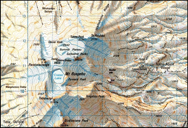 |
Figure 36. Map of Ruapehu oriented with N towards the top, showing glaciers and ski fields (note Whakapapa skifield and the valley of the same name towards the N). Crater Lake's outlet is at the SSE end of that lake, and it pours into the E-trending Whangaehu Gorge. The grid lines are at 1 km spacing; the contour interval is 20 m (100 m between heavy contours). Courtesy of Brad Scott, GNS. |
Photos of hydrothermal and lahar deposits on snow and alpine glacial ice were taken within days of the hydrothermal explosion. By 4 October, the mountain was blanketed in fresh snow, completely masking the recent deposits. Photos such as those included in this report (fresh deposits laid down on ice and snow from erupting high-altitude crater lakes) are comparatively rare.
Dome Shelter, located just N of Crater Lake, was directly in the path of the explosion. It was extensively buried by debris from the explosion and one person inside was badly injured.
Instruments recorded seismic and air-pressure signals associated with the hydrothermal explosion (figure 37). The seismic plot shows a strong wave initially arriving at 2026 NZ local time. The velocity of sound in air is several-fold slower that the velocity of vibrations through rock (seismic waves). In addition, the sound waves were recorded at a station ~ 6 km farther away from the signal source. Consequently the sound signal's first arrival was later.
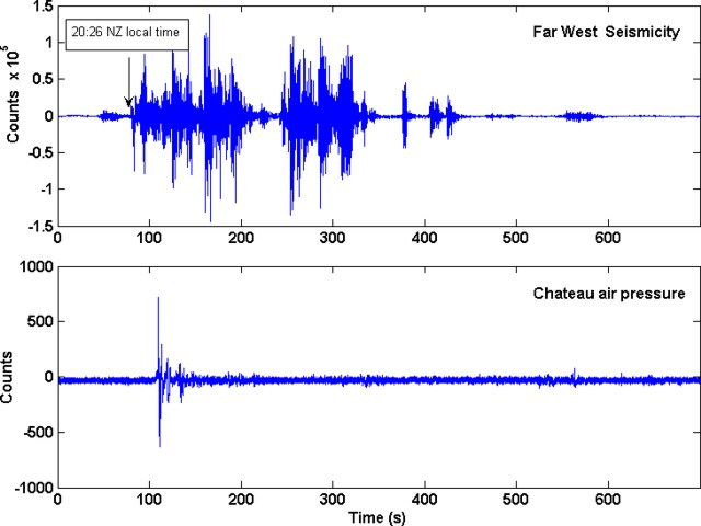 |
Figure 37. Seismic and air pressure plots of the eruption at Ruapehu on 25 September 2007. The seismic data were recorded at the seismic station termed the Far West T-bar, on the N flank of the volcano, ~ 3.1 km from the center of Crater Lake. The air pressure (sound wave) signal was recorded at the Chateau station, 9.1 km from the center of Crater Lake. Courtesy of GeoNet. |
Work is still in progress to understand the complicated lahar dynamics of this event. Three main lahars descended the mountain on 25 September. Two headed roughly E (one via the outlet and associated Whangaehu Gorge, the other, larger, out over the crater walls and down a glacier). Another lahar went N (over the crater walls).
The photo of Ruapehu's summit taken from a plane, shown in figure 35 in BGVN 32:10, was a view from the NE illustrating the scene shortly after the eruption. A similar photo appears here as figure 38, although this photo was taken from the E. In both these photos, the largest (most conspicuous) lahar follows a straight path from the summit area adjacent Crater Lake. It traveled over the Whangaehu glacier.
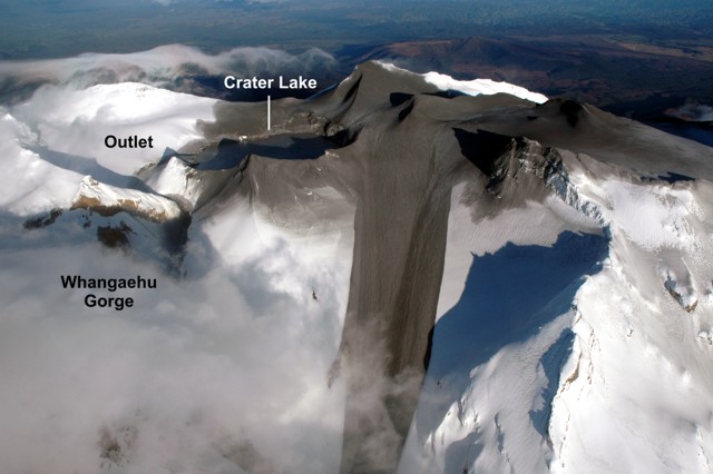 |
Figure 38. Photograph of Ruapehu taken from the E with a view centered on the largest 25 September lahar. That lahar made its descent on the surface of the Whangaehu glacier. The outlet for Crater Lake (upper left) feeds from the Lake's S (left) end, draining down the Whangaehu Gorge. In this photo, the steep sided Gorge becomes shrouded in clouds towards the lower left corner. Courtesy of GeoNet. |
Ejecta apparently accumulated in the N Crater basin (figure 39) before some of it flowed down the Whangaehu glacier. The latter lahar was complex, owing to eruption-blasted water followed by runoff and other possible complexities still under study. The third lahar was small and came down the Ruapehu's N side. It passed near a ski slope (figures 40 and 41).
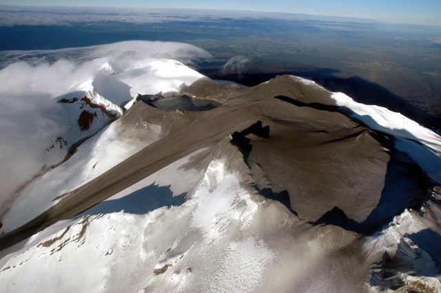 |
Figure 39. A view of Ruapehu taken from the NE. The Whangaehu Gorge (left back) drains from Crater Lake's outlet, containing a narrow, confined lahar there. In the upper center, Crater Lake is surrounded by gray ash. The dark area across the center to left is the large lahar down the Whangaehu Glacier. The large dark circular area at the right is the ash-covered N Crater basin. Courtesy of Brad Scott and GeoNet. |
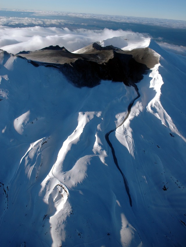 |
Figure 40. This view at Ruapehu was taken from the N and shows a small 25 September lahar down the Whakapapa Valley. The distal end of this lahar descended past the ski slope's Far West T- Bar (a piling for this ski lift is in the right background of the next photo). The prominent ash-covered ridge in the upper center is Dome Ridge, which obscures the view of the lake. Courtesy of GeoNet. |
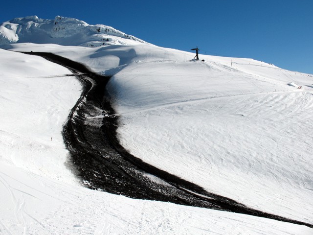 |
Figure 41. A Ruapehu lahar that traveled down the Whakapapa ski field. Levees appear at or near the lahar margins. The snow in this area is firm and groomed for skiing, and the lahar melted it by a few tens of centimeters. Courtesy of GeoNet. |
A view of Crater Lake looking S into the crater from the Dome Shelter (figure 42) shows the strong directionality of the blast to the N (towards Dome Shelter). Numerous small blocks and bombs are visible in the foreground. Near the lake appear some lighter textured deposits on the snow (figure 42). These are rather thin (less than 0.5-1 m thick) and cross some of the darker deposits. Initial field interpretations were that these lighter deposits formed in two ways. One is the deposits mark the absorption of ejected Crater Lake water into the snow pack. The second is that they preserve the aerosol developed on the fringes of a directed blast of steam and water discharged from the Lake. Figure 43 is similar to the previous one, only viewed standing on debris farther to the E, an area where significant runoff formed a long narrow channel, which in the foreground traveled downslope towards the viewer.
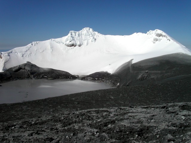 |
Figure 42. Ruapehu's Crater Lake as seen from the N at Dome Shelter. Courtesy of GNS. |
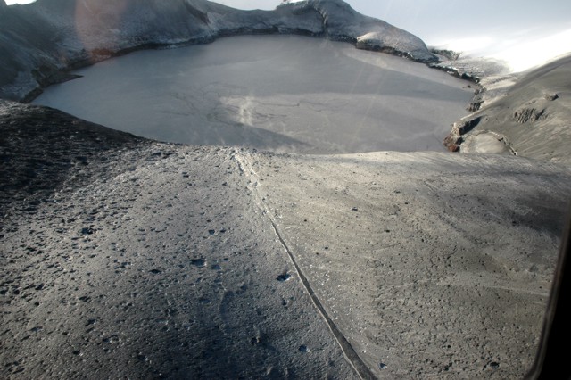 |
Figure 43. A photo of Ruapehu's Crater Lake looking SE from the Whakapapa Glacier showing the outlet (on the Lake's top-right). The lake surface contains disturbances caused by upwelling water and sulfur slicks (dark streaks). Note craters from ballistic ejecta. The long straight line is a runoff channel. Courtesy of GeoNet. |
Dome Shelter and news-reported injury. Dome Shelter was partly buried by typical snow accumulation, over which came the deposits from the hydrothermal eruption, some of which invaded the structure (figure 44). To summarize news stories in the New Zealand Herald and The Sydney Morning Herald, four mountaineers were camped in the Shelter during the explosion. William Pike's left leg was injured and his right leg below the knee was crushed and pinned by deposits. He was rescued and ultimately flown out by helicopter but had suffered severe hypothermia. Doctors said at one point he was very near death, with body temperature in the 25-26°C range. They managed to save him after amputating the lower portion of his right leg. The news also reported that the Shelter was designated for emergency use only (not as a camping shelter).
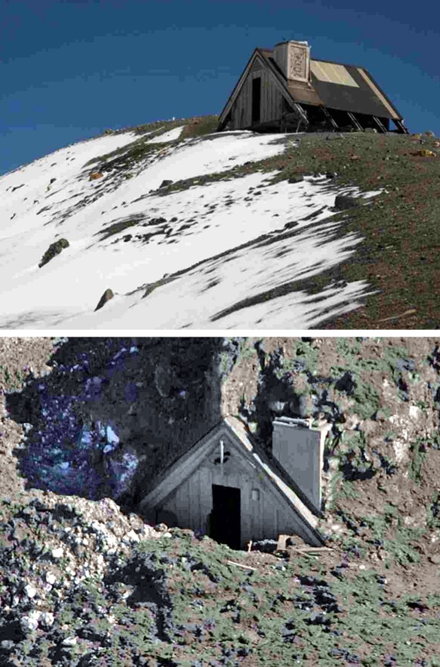 |
Figure 44. Dome Shelter on Ruapehu as seen in relatively snow-free conditions at some point well prior to the eruption (top). Seen from the air after the hydrothermal eruption, the Shelter is covered by seasonal snow followed by mud and debris. Pre-eruption photo credit to Greg Bowker, post-eruption photo credit to Alan Gibson; accessed on the website of the New Zealand Herald. |
GNS noted that the Shelter also houses monitoring instruments, equipment less damaged than initially thought. Data from one of the two seismic systems continued to flow, although the data were rather noisy. Accordingly, GNS began relying on nearby monitoring stations.
Reference. Manville, V., and Cronin, S.J., 2007, Breakout lahar from New Zealand's Crater Lake, Earth Observing Satellite, Transactions, American Geophysical Union, v. 88, no. 43, p. 441-442.
Geological Summary. Ruapehu, one of New Zealand's most active volcanoes, is a complex stratovolcano constructed during at least four cone-building episodes dating back to about 200,000 years ago. The dominantly andesitic 110 km3 volcanic massif is elongated in a NNE-SSW direction and surrounded by another 100 km3 ring plain of volcaniclastic debris, including the NW-flank Murimoto debris-avalanche deposit. A series of subplinian eruptions took place between about 22,600 and 10,000 years ago, but pyroclastic flows have been infrequent. The broad summait area and flank contain at least six vents active during the Holocene. Frequent mild-to-moderate explosive eruptions have been recorded from the Te Wai a-Moe (Crater Lake) vent, and tephra characteristics suggest that the crater lake may have formed as recently as 3,000 years ago. Lahars resulting from phreatic eruptions at the summit crater lake are a hazard to a ski area on the upper flanks and lower river valleys.
Information Contacts: Brad Scott, Institute of Geological & Nuclear Sciences (IGNS), Private Bag 2000, Wairakei, New Zealand (URL: http://www.gns.cri.nz/); New Zealand GeoNet Project (URL: http://www.geonet.org.nz/); New Zealand Herald (URL: http://www.nzherald.co.nz/); Sydney Morning Herald (URL: http://www.smh.com.au/).