Report on Montagu Island (United Kingdom) — March 2008
Bulletin of the Global Volcanism Network, vol. 33, no. 3 (March 2008)
Managing Editor: Richard Wunderman.
Montagu Island (United Kingdom) December 2006 plume seen in satellite imagery
Please cite this report as:
Global Volcanism Program, 2008. Report on Montagu Island (United Kingdom) (Wunderman, R., ed.). Bulletin of the Global Volcanism Network, 33:3. Smithsonian Institution. https://doi.org/10.5479/si.GVP.BGVN200803-390081
Montagu Island
United Kingdom
58.445°S, 26.374°W; summit elev. 1370 m
All times are local (unless otherwise noted)
An ASTER (Advanced Spaceborne Thermal Emission and Reflection Radiometry) satellite image became available, showing a Montagu Island plume blowing NNE on 17 December 2006 (figure 19). A persistent ash plume over Montagu was previously noted in October 2006 ASTER imagery (BGVN 31:11).
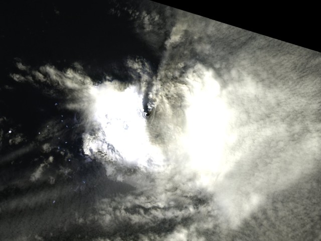 |
Figure 19. ASTER near-infrared image of Montagu Island volcano at 1115 UTC on 17 December 2006. Courtesy of ASTER Volcano Archive. |
Thermal anomalies from Montagu were often detected by MODIS satellite instruments nearly weekly from at least 2006 until 20 September 2007. However, during that interval anomalies were absent for more than two months, from January 2007 through late March 2007. Anomalies were also absent from 21 September 2007 to 17 April 2008. The absence of anomalies could be due to lack of visibility, or the chilling of lava flows after the end of an eruptive phase.
Geological Summary. The largest of the South Sandwich Islands, Montagu consists of a massive shield volcano cut by a 6-km-wide ice-filled summit caldera. The summit of the 11 x 15 km island rises about 3,000 m from the sea floor between Bristol and Saunders Islands. Around 90% of the island is ice-covered; glaciers extending to the sea typically form vertical ice cliffs. The name Mount Belinda has been applied both to the high point at the southern end of the summit caldera and to the young central cone. Mount Oceanite, an isolated peak at the SE tip of the island, was the source of lava flows exposed at Mathias Point and Allen Point. There was no record of Holocene activity until MODIS satellite data, beginning in late 2001, revealed thermal anomalies consistent with lava lake activity. Apparent plumes and single anomalous pixels were observed intermittently on AVHRR images from March 1995 to February 1998, possibly indicating earlier volcanic activity.
Information Contacts: ASTER Volcano Archive (URL: http://ava.jpl.nasa.gov/); Hawai'i Institute of Geophysics and Planetology (HIGP) Thermal Alerts System, School of Ocean and Earth Science and Technology (SOEST), Univ. of Hawai'i, 2525 Correa Road, Honolulu, HI 96822, USA (URL: http://modis.higp.hawaii.edu/);.