Report on Asamayama (Japan) — August 2008
Bulletin of the Global Volcanism Network, vol. 33, no. 8 (August 2008)
Managing Editor: Richard Wunderman.
Asamayama (Japan) Small eruptions in August 2008, the first since 2004
Please cite this report as:
Global Volcanism Program, 2008. Report on Asamayama (Japan) (Wunderman, R., ed.). Bulletin of the Global Volcanism Network, 33:8. Smithsonian Institution. https://doi.org/10.5479/si.GVP.BGVN200808-283110
Asamayama
Japan
36.406°N, 138.523°E; summit elev. 2568 m
All times are local (unless otherwise noted)
Seismicity on 8 August 2008 prompted JMA (Japan Meteorological Agency) to raise the alert level from 1 to 2. Three small eruptions followed in the next few days.
On 10 August, Asama erupted at 0237 and emitted an ash cloud that rose ~400 m above the crater and drifted SE. A second eruption occurred on 11 August. An ash plume rose ~200 m above the crater rim and drifted S. The Tokyo Volcanic Ash Advisory Center reported that the 10 and 11 August eruption plumes extended to an altitude of 3 km and drifted SE and S, respectively.
On 12 August, scientists from ERI climbed to the summit and collected ash samples at the SW rim of the crater. The thickness was less than 5 cm. Under the microscope the ash contains about 10% black or dark brown glass.
The third eruption occurred on 14 August at 0759; the ash plume rose to ~400 m above the crater rim. The Tokyo VAAC again reported that plumes extended to an altitude of 3 km and drifted S.
According to Keisuke Kanda, an official observer in a hut ~2 km from the summit, no explosive sounds were heard there during the three eruptions. The hut is maintained by Komoro City for hikers. Kanda, a city worker, stays at the hut almost 365 days a year.
A red glow on the summit crater was occasionally observed by web-cameras during the night. These events did not trigger MODVOLC thermal alerts.
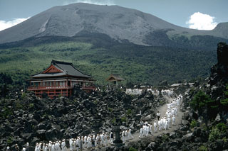
Geological Summary. Asamayama, Honshu's most active volcano, overlooks the resort town of Karuizawa, 140 km NW of Tokyo. The volcano is located at the junction of the Izu-Marianas and NE Japan volcanic arcs. The modern Maekake cone forms the summit and is situated east of the remnant of an older andesitic volcano, Kurofuyama, which was destroyed by a late-Pleistocene landslide about 20,000 years before present (BP). Growth of a dacitic shield volcano was accompanied by pumiceous pyroclastic flows, the largest of which occurred about 14,000-11,000 BP, and by growth of the Ko-Asamayama lava dome on the east flank. Maekake, capped by the Kamayama pyroclastic cone that forms the present summit, is probably only a few thousand years old and has observed activity dating back at least to the 11th century CE. Maekake has had several major Plinian eruptions, the last two of which occurred in 1108 (Asamayama's largest Holocene eruption) and 1783 CE.
Information Contacts: Japan Meteorological Agency (JMA), Otemachi, 1-3-4, Chiyoda-ku Tokyo 100-8122, Japan (URL: http://www.jma.go.jp/); Volcano Research Center, Earthquake Research Institute (ERI), University of Tokyo, Yayoi 1-1-1, Bunkyo-ku, Tokyo 113, Japan (URL: http://www.eri.u-tokyo.ac.jp/topics/ASAMA2004/index-e.html).