Report on Dempo (Indonesia) — January 2009
Bulletin of the Global Volcanism Network, vol. 34, no. 1 (January 2009)
Managing Editor: Richard Wunderman.
Dempo (Indonesia) Sudden phreatic eruption on 1 January 2009
Please cite this report as:
Global Volcanism Program, 2009. Report on Dempo (Indonesia) (Wunderman, R., ed.). Bulletin of the Global Volcanism Network, 34:1. Smithsonian Institution. https://doi.org/10.5479/si.GVP.BGVN200901-261230
Dempo
Indonesia
4.016°S, 103.121°E; summit elev. 3142 m
All times are local (unless otherwise noted)
According to a report by Indonesia's Center of Volcanology and Geological Hazard Mitigation (CVGHM), Dempo had a phreatic eruption on 1 January 2009. The event resulted in a strong sulfur odor and an ash (or cinder) rain that was noted as far as ~ 10 km from the summit. During 27 December 2008 to 1 January 2009, fog prevented direct observations of the summit; clouds over the summit area are a common occurrence. The one available photo of the eruption showed a whitish-colored plume rising perhaps a few kilometers over the summit.
On 1 January authorities raised the alert status from 1 (normal) to 2 (alert, "Waspada" in Indonesian), on a scale that ranges from 1-4. Visitors and residents were advised not to go within a 2-km radius of the summit. A 2 January report from CVGHM noted that both local volcanic and regional tectonic earthquakes were recorded during 27 December 2008 through 1 January 2009 (table 1).
Table 1. Highlights of Dempo seismicity recorded during 27 December 2008 to 1 January 2009. Courtesy of CVGHM.
| Date | Seismicity |
| 27 Dec 2008 | One local volcanic (A-type), and two tectonic. |
| 28 Dec 2008 | One local volcanic (A-type), and one air blast event. |
| 29 Dec 2008 | One local volcanic, five air blasts, and two tectonic. |
| 30 Dec 2008 | One shallow local volcanic, one air blast, one low-frequency, and one tectonic. |
| 31 Dec 2008 | One local volcanic, one air blast, and two tectonic not at the volcano. |
| 01 Jan 2009 | One local volcanic related to the explosive eruption. |
As of early 2009, no thermal anomalies had been measured over Dempo by the MODVOLC infrared satellite system for at least the last 5 years. ASTER images from 2001-2007 show extensive cloud cover.
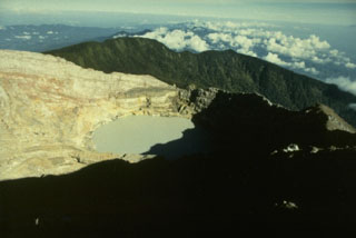
Geological Summary. Dempo is a stratovolcano that rises above the Pasumah Plain of SE Sumatra. The andesitic complex has two main peaks, Gunung Dempo and Gunung Marapi, constructed near the SE rim of a 3-km-wide amphitheater open to the north. The high point of the older Gunung Dempo crater rim is slightly lower, and lies at the SE end of the summit complex. The taller Marapi cone was constructed within the older crater. Remnants of seven craters are found at or near the summit, with volcanism migrating WNW over time. The active 750 x 1,100 m active crater cuts the NW side of the Marapi cone and contains a 400-m-wide lake at the far NW end. Eruptions recorded since 1817 have been small-to-moderate explosions that produced local ashfall.
Information Contacts: Center of Volcanology and Geological Hazard Mitigation (CVGHM), Jalan Diponegoro 57, Bandung 40122, Indonesia (URL: http://vsi.esdm.go.id/); Hawai'i Institute of Geophysics and Planetology (HIGP) Thermal Alerts System, School of Ocean and Earth Science and Technology (SOEST), Univ. of Hawai'i, 2525 Correa Road, Honolulu, HI 96822, USA (URL: http://modis.higp.hawaii.edu/).