Report on Lewotobi (Indonesia) — January 2009
Bulletin of the Global Volcanism Network, vol. 34, no. 1 (January 2009)
Managing Editor: Richard Wunderman.
Lewotobi (Indonesia) Increase in seismicity during May 2008; more details on 2003 eruption
Please cite this report as:
Global Volcanism Program, 2009. Report on Lewotobi (Indonesia) (Wunderman, R., ed.). Bulletin of the Global Volcanism Network, 34:1. Smithsonian Institution. https://doi.org/10.5479/si.GVP.BGVN200901-264180
Lewotobi
Indonesia
8.542°S, 122.775°E; summit elev. 1703 m
All times are local (unless otherwise noted)
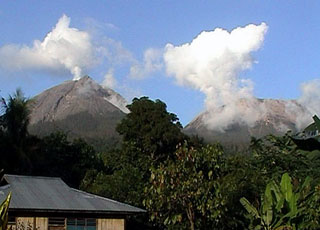
On 29 May 2008, the Center of Volcanology and Geological Hazard Mitigation (CVGHM) raised the Alert Level for the Flores Island volcano Lewotobi to 2 (on a scale of 1-4) due to an increase in seismicity during 12-29 May. White plumes typically rose about 25 m above the crater and drifted E; visual observations indicated no changes.
Explosive ash eruptions and high levels of seismicity occurred during May-September 2003 (BGVN28:06 and 28:10). Seismicity declined dramatically after an eruption on 31 August, and all volcanic earthquakes ceased after 3 September. The absence of reports during October 2003 until mid-May 2008 suggests Lewotobi apparently entered a protracted period of quiescence until May 2008. MODVOLC thermal surveillance of Lewotobi subsequent to the activity of October 2003 has not revealed any significant thermal activity to February 2009.
Additional details of 2003 eruption.According to an Agence France-Presse (AFP) news report, an eruption on 31 August 2003 took place at 1935. The article noted that hundreds of people from at least six villages fled E from their homes to the village of Konga. AFP said that volcanic material caused fires in forests within a 1-km radius of the crater and damaged crops on the flanks. On 1 September CVGHM reported to the Darwin Volcanic Ash Advisory Center (VAAC) that an ash plume rose ~2.5 km above the crater and drifted W, but the plume was not detected in imagery.
Following that 2003 eruption, according to the daily Jakarta Post, at least 565 villagers living on the slopes of Lewotobi were affected by sulfur and ash emissions. The residents experienced respiratory problems and skin afflictions. A 2008 Jakarta Post article indicated that an estimated 10,000 people live on the slopes of Lewotobi, most of them farming the fertile volcanic soil in the area.
Geological Summary. The Lewotobi edifice in eastern Flores Island is composed of the two adjacent Lewotobi Laki-laki and Lewotobi Perempuan stratovolcanoes (the "husband and wife"). Their summits are less than 2 km apart along a NW-SE line. The conical Laki-laki to the NW has been frequently active during the 19th and 20th centuries, while the taller and broader Perempuan has had observed eruptions in 1921 and 1935. Small lava domes have grown during the 20th century in both of the summit craters, which are open to the north. A prominent cone, Iliwokar, occurs on the E flank of Perampuan.
Information Contacts: Center of Volcanology and Geological Hazard Mitigation (CVGHM), Jalan Diponegoro 57, Bandung 40122, Indonesia (URL: http://vsi.esdm.go.id/); Hawai'i Institute of Geophysics and Planetology (HIGP) Thermal Alerts System, School of Ocean and Earth Science and Technology (SOEST), Univ. of Hawai'i, 2525 Correa Road, Honolulu, HI 96822, USA (URL: http://modis.higp.hawaii.edu/); Darwin Volcanic Ash Advisory Centre (VAAC), Bureau of Meteorology, Northern Territory Regional Office, PO Box 40050, Casuarina, NT 0811, Australia (URL: http://www.bom.gov.au/info/vaac/); Agence France-Presse (URL: http://www.afp.com/); Jakarta Post (URL: http://www.thejakartapost.com/).