Report on Aira (Japan) — March 2009

Bulletin of the Global Volcanism Network, vol. 34, no. 3 (March 2009)
Managing Editor: Richard Wunderman.
Aira (Japan) Recent (2007-2009) explosive eruptions and intermittent plumes
Please cite this report as:
Global Volcanism Program, 2009. Report on Aira (Japan) (Wunderman, R., ed.). Bulletin of the Global Volcanism Network, 34:3. Smithsonian Institution. https://doi.org/10.5479/si.GVP.BGVN200903-282080
Aira
Japan
31.5772°N, 130.6589°E; summit elev. 1117 m
All times are local (unless otherwise noted)
Our last reports on Sakura-jima (BGVN 31:06 and 32:04) discussed an eruption from Showa crater on 4 June 2006, the first eruption outside the summit crater since 1946. It also provided a chronology of plume observations between 7 June 2006 and 20 March 2007.
The current report continues the chronology of plume observations from 20 March 2007 to 24 April 2009 (table 15). Most of the plumes described since 20 March 2007 did not exceed 3 km altitude (figure 29). The tallest plume recorded on the table, an ash plume on 9 April 2009, rose to about 5 km altitude.
Table 15. Heights and drift of plumes and their character at Sakura-jima from 20 March 2007 to 24 April 2009. Courtesy of Tokyo Volcanic Ash Advisory Center, pilot reports, and the Japan Meteorological Agency (JMA). Times and dates are local.
| Date | Plume altitude/drift | Observations |
| 16 May 2007 | 1.2-2.7 km/ NW | -- |
| 20-22 May 2007 | 1.2-2.7 km/ up | -- |
| 23-24, 26-28 May 2007 | 1.8-2.1 km/ E, SE, up | -- |
| 31 May-01 Jun 2007 | 2.1-2.4 km/ up | -- |
| 04 Jun-05 Jun 2007 | 2.1-2.4 km/ W, NW, E | Ash not detected by satellite imagery. |
| 08, 10, 11 Jun 2007 | 2.1 km/ S | Ash not detected by satellite imagery. |
| 16 Jun 2007 | -- | Explosion. Ash not detected by satellite imagery. |
| 20-21 Jun 2007 | 2.4 km/N | Ash not detected by satellite imagery. |
| 04 Aug 2007 | -- | Explosion. Ash not detected by satellite imagery. |
| 29 Oct 2007 | 3.7 km/E | -- |
| 23-24 Dec 2007 | 2.7 km/S | -- |
| 02, 07 Jan 2008 | -- | Explosions reported. |
| 03 Feb 2008 | 1.5-2.7 km/ SE | Ash not detected by satellite imagery. |
| 05-06 Feb 2008 | 1.2-2.1 km/ SE | Ash not detected by satellite imagery. |
| 11-15 Apr 2008 | 2.1-3.4 km/ various | -- |
| 19 Apr 2008 | 4.6 km/E | Plume contained ash. |
| 20, 23-30 Apr 2008 | 2.4 km/various | -- |
| 06-07 May 2008 | 2.4-3.4 km/S | -- |
| 08 May 2008 | 4 km/E | -- |
| 15-22 May 2008 | 1.8-3.4 km/various | -- |
| 24 May 2008 | -- | Explosion reported. |
| 30 May-01 Jun 2008 | 2.1-3 km/various | -- |
| 09 Jun 2008 | 2.1 km/S | -- |
| 10-11 Jun 2008 | -- | Explosions reported. |
| 12-13 Jun 2008 | 3.4 km/various | Plumes contained ash. |
| 28 Jun 2008 | -- | Explosion reported. |
| 05 Jul 2008 | 2.7 km/E | -- |
| 10, 13 Jul 2008 | 2.7 km | Plumes contained ash. |
| 25-28 Jul 2008 | 2.4-4.3 km/various | Plumes contained ash. |
| 10 Aug 2008 | >2.7 km/NW | -- |
| 23 Aug 2008 | -- | Explosion reported. |
| 07 Sep 2008 | 2.1 km/straight up | -- |
| 03 Oct 2008 | 2.7 km | -- |
| 09, 15 Jan 2009 | 2.4, 1.8 km/SE | -- |
| 28 Jan -03 Feb 2009 | 1.8-3.4 km/various | -- |
| 01-02 Feb 2009 | -- | Eight eruptions; bombs up to 800 m from Showa crater. On 2 Feb, JMA Alert level to 3. |
| 04-05 Feb 2009 | 2.1-2.4 km/SE | Explosions and eruptions. |
| 09-12 Feb 2009 | 0.6-2.4 km/SE | Ash plumes. |
| 19 Feb 2009 | -- | JMA lowered Alert Level to 2. |
| 22 Feb 2009 | 2.7 km/N | Explosion. |
| 28 Feb-04 Mar 2009 | 1.8-3 km/S | Eruptions or explosions, three Vulcanian explosions from Showa crater ejected bombs up to 1.3 km. Deformation; expansion of edifice (tiltmeter). On 2 Mar, JMA Alert Level to 3. |
| 07-10 Mar 2009 | 1.8-2.9 km/N, S | Twelve Vulcanian explosions from Showa crater. Ejected bombs up to 1.8 km. |
| 14 Mar 2009 | 1.5-2.1 km/SE, E | Two Vulcanian explosions ejected bombs up to 800 m. |
| 17 Mar 2009 | 2.1 km/E | Eruption. |
| 20, 23 Mar 2009 | -- | Explosions; weak incandescence on 23rd. |
| 26 Mar 2009 | -- | Eruption. |
| 27-30 Mar 2009 | 2.1 km/SE | Weak eruptions, strong steam emissions. |
| 05-07 Apr 2009 | 2.1-3 km/SE, S | Explosions and eruptions. |
| 08 Apr 2009 | 2.7 km | Eruption. |
| 09 Apr 2009 | ~5 km/SW | Vulcanian explosion, pyroclastic flow to 1 km E, bombs to 1.3 km, heavy ashfall at Kagoshima City. |
| 10 Apr 2009 | 2.1-2.7 km/W, S | -- |
| 24 Apr 2009 | -- | JMA lowered alert level to 2. |
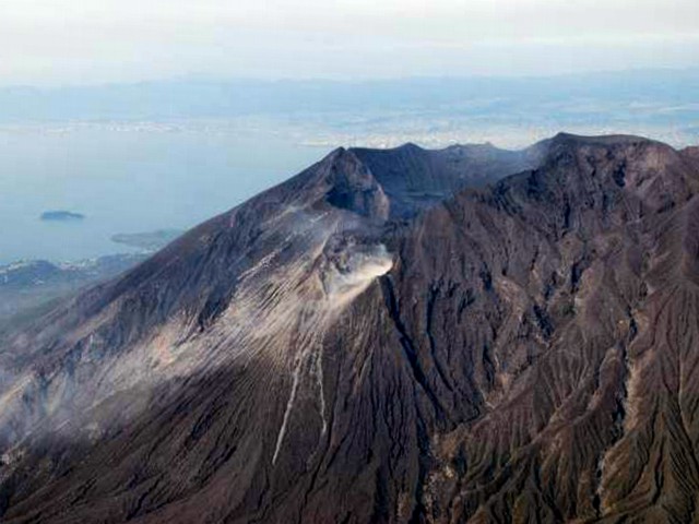 |
Figure 29. Aerial photograph taken from the W of a plume from Sakura-jima's Showa crater as seen on 10 March 2009. Courtesy of JMA. |
On 19 February 2009 JMA lowered the Alert Level from 3 to 2, because after the 1-5 February explosions, no eruptions had occurred either from Showa crater or Minamidake summit crater, seismicity was low, and no crustal deformation was observed (figure 30). As a result of heightened activity, the Alert Level was raised to 3 on 2 March, but dropped to 2 on 24 April 2009 due to low seismicity, lack of deformation, and absence of large eruptions. According to JMA, the shape of Showa crater has not changed recently, but the depth of the crater had increased. Photographs taken during an overflight on 10 March 2009 (figures 31 and 32) showed changes in morphology and temperature.
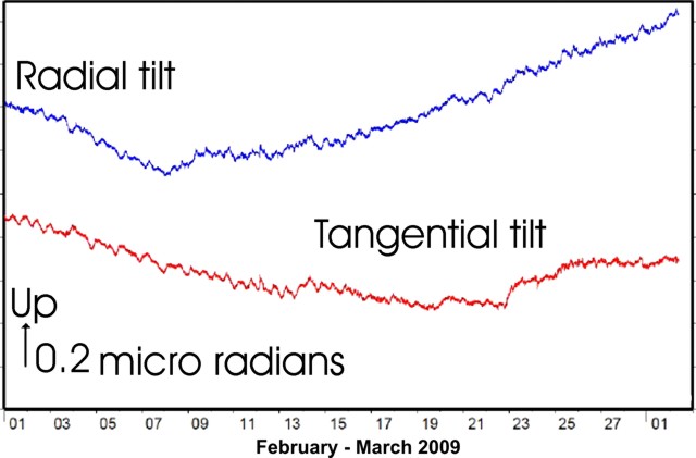 |
Figure 30. Sakura-jima tilt recorded at Arimura during February 2009. The vertical axis indicates the sense and magnitude of movement. Data from Osumi Kasen Kokudo (Japan's Ministry of Land, Infrastructure, Transport and Tourism). Courtesy of JMA. |
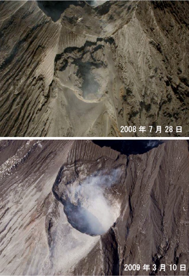 |
Figure 31. A comparison of the morphology of Sakura-jima's Showa crater: (top) 28 July 2008, (bottom) 10 March 2009. Courtesy of JMA. |
 |
Figure 32. N-looking infrared photo of Sakura-jima's Showa crater on 10 March 2009. Scale at right shows the estimated temperature (°C). Note the high temperature in Showa crater. The crater rim at higher elevation (upper left) is called Minami-dake ("M" on the geologic map in the previous issue). Courtesy of JMA. |
An article in Asahi newspaper contained several photos of the 9 April 2009 ashfall in Kagoshima City, about 10 W of Sakura-jima. This was the heaviest ashfall since October 2002.
During the last two years, the only thermal anomaly recorded by MODIS-MODVOLC for Sakura-jima was on 17 December 2008 (1 pixel).
Two recently published articles (citations below) describe the mechanism of explosive eruptions at Sakura-jima and two other Japanese volcanoes, and color measurements of Sakura-jima's ash deposits.
References. Iguchi, M., Yakiwara, H., Tameguri, T., Hendrasto, M. and Hirabayashi, J., 2008. Mechanism of explosive eruption revealed by geophysical observations at the Sakurajima, Suwanosejima and Semeru volcanoes: Journal of Volcanology and Geothermal Research, v. 178, no. 1, p. 1-9.
Yamanoi, Y.,Takeuchi Y., Okumura S., Nakashima S., and Yokoyama, T., 2008. Color measurements of volcanic ash deposits from three different styles of summit activity at Sakurajima volcano, Japan: Conduit processes recorded in color of volcanic ash: Journal of Volcanology and Geothermal Research, v. 178, no. 1, p. 81-93.
Geological Summary. The Aira caldera in the northern half of Kagoshima Bay contains the post-caldera Sakurajima volcano, one of Japan's most active. Eruption of the voluminous Ito pyroclastic flow accompanied formation of the 17 x 23 km caldera about 22,000 years ago. The smaller Wakamiko caldera was formed during the early Holocene in the NE corner of the caldera, along with several post-caldera cones. The construction of Sakurajima began about 13,000 years ago on the southern rim and built an island that was joined to the Osumi Peninsula during the major explosive and effusive eruption of 1914. Activity at the Kitadake summit cone ended about 4,850 years ago, after which eruptions took place at Minamidake. Frequent eruptions since the 8th century have deposited ash on the city of Kagoshima, located across Kagoshima Bay only 8 km from the summit. The largest recorded eruption took place during 1471-76.
Information Contacts: Japan Meteorological Agency (JMA), Otemachi, 1-3-4, Chiyoda-ku Tokyo 100-8122, Japan (URL: http://www.jma.go.jp/); Tokyo Volcanic Ash Advisory Center (VAAC), Tokyo, Japan (URL: http://ds.data.jma.go.jp/svd/vaac/data/); Hawai'i Institute of Geophysics and Planetology (HIGP) Thermal Alerts System, School of Ocean and Earth Science and Technology (SOEST), Univ. of Hawai'i, 2525 Correa Road, Honolulu, HI 96822, USA (URL: http://modis.higp.hawaii.edu/); Yukio Hayakawa, Gunma University, Faculty of Education, Aramaki 4-2, Maebashi 371-8510, Japan; Asahi newspaper (URL: https://www.asahi.com/).