Report on Tungurahua (Ecuador) — August 2009

Bulletin of the Global Volcanism Network, vol. 34, no. 8 (August 2009)
Managing Editor: Richard Wunderman.
Tungurahua (Ecuador) Vascún River map; lahar concerns; decreased activity in mid-2009
Please cite this report as:
Global Volcanism Program, 2009. Report on Tungurahua (Ecuador) (Wunderman, R., ed.). Bulletin of the Global Volcanism Network, 34:8. Smithsonian Institution. https://doi.org/10.5479/si.GVP.BGVN200908-352080
Tungurahua
Ecuador
1.467°S, 78.442°W; summit elev. 5023 m
All times are local (unless otherwise noted)
Activity at Tungurahua began to decline in late June 2009 and continued this trend into early September. July and August 2009 were characterized by an absence of explosions, a marked decrease in ash emissions, and weak steam emissions. Although no new pyroclastic material was deposited in July or August 2009, the Instituto Geofísico-Escuela Politécnica Nacional (IG) still warned that heavy rains and the great amount of material on the upper slopes presented a danger of lahars and mudflows.
Update on 22 August flood. Last month's report (BGVN 34:07) discussed a 22 August 2008 flood of the Vascún River (figure 44) after a natural dam failed. The flood destroyed two homes in the district of Las Ilusiones as well as the El Salado swimming pool complex, leaving two people injured and two others missing.
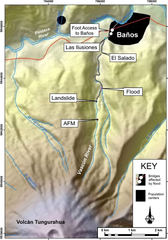 |
Figure 44. Topographic map of the Vascún River on the N flank of Tungurahua, as well as the locations of the dam failure at the landslide and the districts of El Salado and Las Ilusiones, which were affected by the flood waters and associated sediment. "AFM" refers to an acoustical-flow monitor, a device to help detect processes such as mass wasting and pyroclastic flows along the river (Hadley and Lahusen, 1993). The heavy line along the river below the natural dam indicates the portion of the river through which the flood and debris traveled. Courtesy of IG. |
According to a 24 August 2008 article of the newspaper El Universo, strong rains began at approximately 2000 on 22 August and an earthquake was felt by residents in El Salado around 2345. El Universo stated that after the dam's failure, flood waters containing volcaniclastic material reached the El Salado area in ~ 5 minutes. The IG estimated that the flood had traveled at a velocity of 4.7-6.7 m/s.
Two photographs showed bridges that had been visibly damaged by the event (figure 42 in BGVN 34:07). One bridge is located on the main road to Baños, adjacent to the city. The other bridge, 100 m upstream from the first, serves a secondary road. Officials plan on reviewing those bridge structures to determine whether they should be reinforced to avoid any flood-related damage in the future.
El Universo reported that the two missing persons were young children who lived in one of the destroyed houses along the river in Las Ilusiones. Searches were unsuccessful and El Universo reported that the search concluded in September 2008.
References. Hadley, K.C., and Lahusen, R.G., 1993. Technical manual for acoustic flow monitor. US Geol. Surv., Open-file Rep. 93-00, 19 pp.; Lahar-Detection System, USGS scientists create new method for detecting lahars (URL: http://volcanoes.usgs.gov/activity/methods/hydrologic/lahardetection.php).
Geological Summary. Tungurahua, a steep-sided andesitic-dacitic stratovolcano that towers more than 3 km above its northern base, is one of Ecuador's most active volcanoes. Three major edifices have been sequentially constructed since the mid-Pleistocene over a basement of metamorphic rocks. Tungurahua II was built within the past 14,000 years following the collapse of the initial edifice. Tungurahua II collapsed about 3,000 years ago and produced a large debris-avalanche deposit to the west. The modern glacier-capped stratovolcano (Tungurahua III) was constructed within the landslide scarp. Historical eruptions have all originated from the summit crater, accompanied by strong explosions and sometimes by pyroclastic flows and lava flows that reached populated areas at the volcano's base. Prior to a long-term eruption beginning in 1999 that caused the temporary evacuation of the city of Baños at the foot of the volcano, the last major eruption had occurred from 1916 to 1918, although minor activity continued until 1925.
Information Contacts: Geophysical Institute (IG), Escuela Politécnica Nacional, Apartado 17-01-2759, Quito, Ecuador (URL: http://www.igepn.edu.ec/); El Universo (URL: http://www.eluniverso.com/).