Report on Gaua (Vanuatu) — October 2009
Bulletin of the Global Volcanism Network, vol. 34, no. 10 (October 2009)
Managing Editor: Richard Wunderman.
Gaua (Vanuatu) Eruptions during September-November 2009 cause ashfall and evacuations
Please cite this report as:
Global Volcanism Program, 2009. Report on Gaua (Vanuatu) (Wunderman, R., ed.). Bulletin of the Global Volcanism Network, 34:10. Smithsonian Institution. https://doi.org/10.5479/si.GVP.BGVN200910-257020
Gaua
Vanuatu
14.281°S, 167.514°E; summit elev. 729 m
All times are local (unless otherwise noted)
An eruption on Gaua Island in September 2009 was described in a report from the Vanuatu Geohazards unit (Vanuatu Department of Geology, Mines, and Water Resources, DGMWR) sent by Esline Garaebiti on 16 November. A later government report and several news reports extended into late November. According to the DGMWR, elevated volcanism in 1973 led to the evacuation of the entire island, which then was home to 600 people; Gaua Island now has more than 3,000 residents. News reports cited no fatalities and by the end of November hundreds of evacuees had moved to the safer E side of the island.
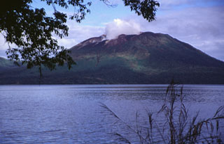
Gaua island, round in shape, is ~20 km in diameter and lies in the N part of the archipelago (Banks Islands, Torba Province), ~ 100 km NE of the closest parts of the island Espiritu Santo (figure 5). The volcano is basaltic to andesitic in composition, and it contains a 6 x 9 km summit caldera that is ~ 700 m deep. Within the caldera sits Mount Garat (Gharat), a prominent cone that supports the summit and the crater complex that is the scene of the eruption. This caldera contains a large, crescent-shaped lake (Lake Letas) (Thery and Thery, 1995).
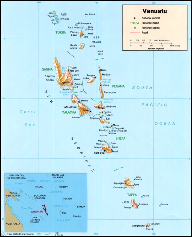 |
Figure 5. Map of Vanuatu (formerly New Hebrides) showing major islands and province names. On this map Gaua island is labeled with its other name, Santa Maria. Inset shows Vanuatu with respect to other islands in this portion of the South Pacific. Ambrym volcano, S of Gaua at the E extent of Malampa province, sits on the island of the same name. Courtesy of Relief Web and from an original map by the Central Intelligence Agency. |
Activity during September-October 2009. Toward the end of September 2009, the island's inhabitants reported both strong degassing from Mount Garat's summit, gradual discoloration of the SW part of Lake Letas, and the strong smell of sulfur in the villages on the W coast. Mont Garat eruptions probably started on 27 September 2009.
Around noon on 29 September 2009 a group of young men hunting close to the volcano witnessed a series of large explosions propelling an umbrella-shaped column of ash up to a height of ~ 3 km. They also noted a small pyroclastic flow limited to the W caldera. Due to prevailing E wind on that day, minor ashfalls were reported on the W part of Gaua. This explosive episode was also detected by the satellite-borne ozone monitoring instrument (OMI ) in measurements of sulfur dioxide (SO2) emissions the same day (figure 6).
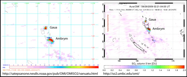 |
Figure 6. SO2 emissions recorded over and around Gaua at 0224 UTC on 29 September 2009 corresponding to the eruptive activity seen in the field. Note the higher, but normal, SO2 emission above Ambrym ~250 km farther S. Courtesy of DGMWR, with data provided by the OMI website. |
During 2-8 October 2009 a DGMWR team visiting the volcano found elevated SO2. They recorded an average flux of ~ 3,000 tons/day. They also noted an increase of the discolored area in Lake Létas (figures 7 and 8). Vegetation on NW part of the volcanic edifice, present in 2007, had been burned by acidic gases released from the volcano (figure 9). The team indicated that gas emissions had begun days to weeks earlier to cause such damage.
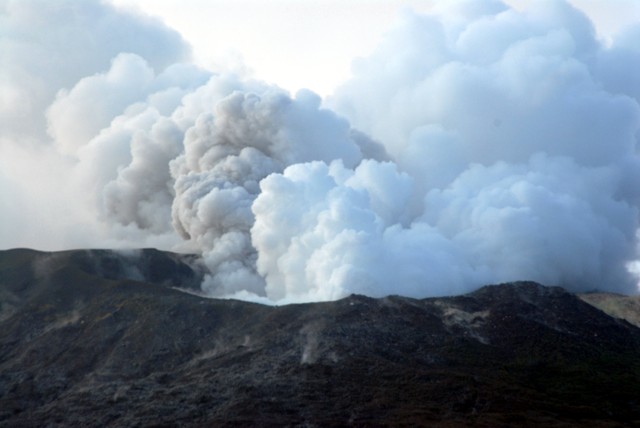 |
Figure 7. Continuous degassing from the summit crater of Gaua. There are at least three active vents in the crater, one of which released a combination ash and gas. Photo taken 6 October 2009, courtesy S. Wallez. |
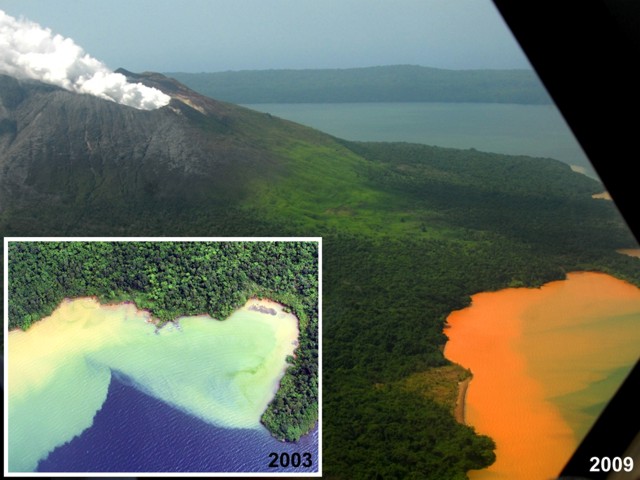 |
Figure 8. Strong discoloration was present at Gaua in the SW part of Lake Létas in 2003 (inset) and in 2009 (background). The 2003 photo showed discoloration with shades of green to pale yellow. The 2009 photo showed intense red-orange discoloration. Photos courtesy DGMWR (2003) and S. Wallez (2009). |
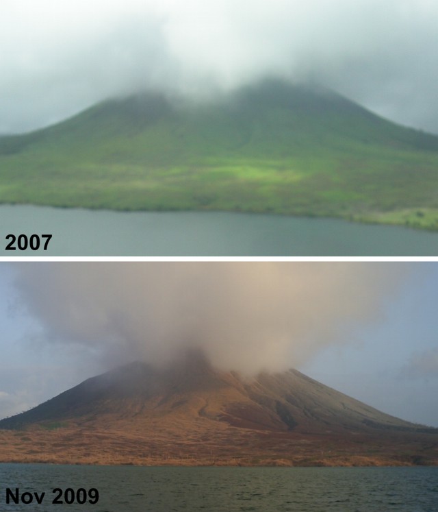 |
Figure 9. Views of Gaua's NW flank taken in the year 2007 and in November 2009, highlighting the almost complete loss of green vegetation. Photos courtesy of P. Bani, Research Institute for Development (IRD). |
The team installed a seismic station on 2 October 2009 to help track the volcanic activity. Many explosions were recorded during 10-11 October (figure 10), and on 13 October the seismic signals suggested strong volcanism as well as continuous degassing. Consequently the Alert Level was raised to 2 (on a scale of 0-4), advising the population not to venture close to the volcano and to stay out of potential drainages that might serve as flow paths.
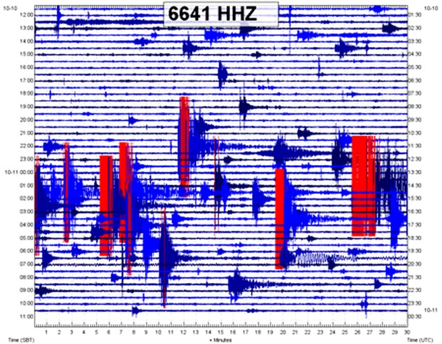 |
Figure 10. Seismic record from the Gaua seismic station illustrating that many explosions occurred between 1200 on 10 October 2009 and 1200 on 11 October 2009. Courtesy of DGMWR. |
Activity during November 2009. From the end of October to around 4 November, witnesses noted explosions with strong ash emissions (figure 11). A substantial ash plume, both reported by observers and confirmed by seismic recording, occurred on 31 October 2009. This was followed by ashfall in the NW part of the island, where 53 inhabitants were relocated to safer areas.
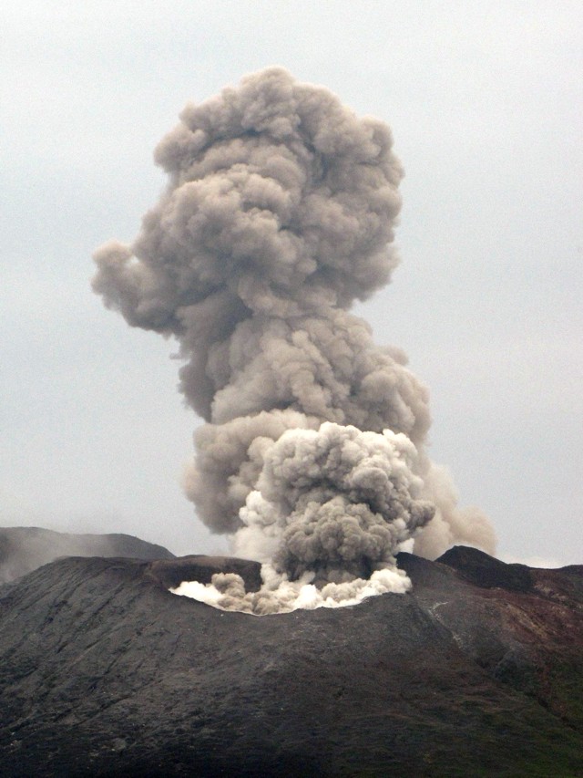 |
Figure 11. Plumes released at Gaua on 3 November 2009. All three active vents emitted plumes, one a vigorous ash plume. Photo courtesy of Sylvain Todman, DGMWR. |
Gaua Bulletin No. 3 from DGMWR, dated 24 November 2009, reported a large explosion around 1400 on 18 November. The explosion produced very dense and high ash columns that blew W. The ash plumes from the 31 October and 18 November events photographed from the airport but were apparently not assessed for plume heights. Activity remained significant through at least 24 November. DGMWR recommended alert level 2 and noted the persisting danger of ashfalls and mudflows.
News media reports and other data. Radio Australia News reported on 2 October 2009 that the last time the hazard concern was so high was in 1974 when volcanism led to inhabitants evacuated from the island for months. According to Radio Australia News in an interview with Charles Bice (one of the Gaua Island community headmen), the early explosions had been heard by both residents and pilots on Air Vanuatu flights. During September-October, residents also found ash on their cabbage crops.
A 26 November Agency France-Presse report indicated that the Red Cross was dispensing containers and water purification tablets. It said the public had suffered respiratory problems and diaharrea. Rural water supplies often come from surface water, or from rainwater collected from areas such as roofs, and then stored in open drums or cisterns. These sources are often vulnerable to contamination from ashfall.
A Vanuatu newspaper article by Len Garae printed after 18 November noted that by then the first phase of evacuation, aided by three ships, had taken ~ 159 villagers from the high-risk zone on the W side of the island to the E side of the island. The article stated that a larger eruption would mean evacuation of an additional 200 villagers on the island's W shoreline. An even more vigorous eruption would require inter-island ships to move residents to other islands.
A Vanuatu news article emphasized three new explosion on 26 November and one on 27 November. It said that the additional villagers on the W side of the island were in the process of evacuating. Although yet to be confirmed elsewhere, the article said "the entire village of 'Waterfall' was destroyed by landslides."
MODIS thermal alerts were absent during the 2009 eruption.
A video shot in January 2003 from a low-flying helicopter showed fumarolic plumes rising from the summit craters. The video is available on YouTube from Geoff Mackley (http://www.youtube.com/user/geoffmackley).
Reference. Thery, L., and Thery, J., 1995, Bathymetrie du lac Letas lle de GAUA (Banks) (Vanuatu), Port-Vila, Vanuatu: Institut Francais de Recherche Scientifique pour le Developpement en Cooperation, 1995. 17 p. : ill., maps; 28 cm. Series?Sciences de la terre geologie-geophysique ; no. 10 (in French and English)
Geological Summary. The roughly 20-km-diameter Gaua Island, also known as Santa Maria, consists of a basaltic-to-andesitic stratovolcano with an 6 x 9 km summit caldera. Small vents near the caldera rim fed Pleistocene lava flows that reached the coast on several sides of the island; littoral cones were formed where these lava flows reached the ocean. Quiet collapse that formed the roughly 700-m-deep caldera was followed by extensive ash eruptions. The active Mount Garet (or Garat) cone in the SW part of the caldera has three pit craters across the summit area. Construction of Garet and other small cinder cones has left a crescent-shaped lake. The onset of eruptive activity from a vent high on the SE flank in 1962 ended a long period of dormancy.
Information Contacts: E. Garaebiti, S. Todman, C. Haruel, D. Charley, D. Nakedau, J. Cevuard, and A. Worwor, Department of Geology, Mines and Water Resources (DGMWR), Geohazards Unit, Vanuatu (URL: http://www.vmgd.gov.vu/vmgd/); P. Bani, Institut de recherche pour la developpment (IRD), Noumea, New Caledonia (URL: http://www.ird.nc/); OMI (Ozone Monitoring Instrument) Sulfur Dioxide Group, Joint Center for Earth Systems Technology, University of Maryland Baltimore County (UMBC), 1000 Hilltop Circle, Baltimore, MD 21250, USA (URL: https://so2.gsfc.nasa.gov/); Relief Web (URL: https://reliefweb.int/); Agence France-Press (AFP) (URL: http://www.afp.com/); Radio Australia News (URL: http://www.radioAustralianews.net.au); The Independent/L'Indépednant, Vanuatu (URL: http://www.independent.vu/); Geoff Mackley, PO Box 12926, Penrose, Auckland 1135, New Zealand (URL: http://www.youtube.com/user/geoffmackley, http://www.geoffmackley.com/).