Report on Kerinci (Indonesia) — December 2009
Bulletin of the Global Volcanism Network, vol. 34, no. 12 (December 2009)
Managing Editor: Richard Wunderman.
Kerinci (Indonesia) Eruptions, ash plumes, and seismicity during 1-21 April 2009
Please cite this report as:
Global Volcanism Program, 2009. Report on Kerinci (Indonesia) (Wunderman, R., ed.). Bulletin of the Global Volcanism Network, 34:12. Smithsonian Institution. https://doi.org/10.5479/si.GVP.BGVN200912-261170
Kerinci
Indonesia
1.697°S, 101.264°E; summit elev. 3800 m
All times are local (unless otherwise noted)
Since a 2004 eruption, Kerinci had been relatively quiet except for ash plumes in September 2007 and ash and steam plumes in February, March, and May 2008 (BGVN 33:05). Eruptions sent ash plumes hundreds of meters above the crater during the first three weeks of April 2009, causing ashfall 8 km away. A report on this period by the Center of Volcanology and Geological Hazard Mitigation (CVGHM) noted that the active crater normally emits whitish plumes ~300 m above the peak. During September 2007 through at least 21 April 2009 the Alert Level remained at 2 (on a scale of 1-4). Residents and visitors have been advised to remain at least 1 km from the summit and to don masks in cases of heavy ashfall.
According to CVGHM, seismicity also increased at Kerinci during the first three weeks of April 2009. The signals were generally dominated by those from eruptions and their associated seismically detected signals traveling through air (as opposed to rock), 'air blasts.' The daily average of air blasts was 38, with the daily maximum reaching 54. The amplitudes of eruptive earthquake signals were 5-49 mm; the amplitudes of the air blasts were 0.5-9 mm. In addition, earthquakes during this 3-week period also included those of deep volcanic origin on 9 and 10 April (1 per day).
The increased seismicity was accompanied by steam-, ash-, or cinder-bearing plumes, sometimes dense, that rose as high as 500-600 m above the crater. On 3 April an eruption reached ~500 m above the crater; variable plumes continued through 12 April. A nearby observation post reported the rumbling of eruptions and ashfall during 19-20 April that extended as much as 8 km from the crater.
The eruptions deposited loose material (ash, cinders, lapilli, volcanic bombs, etc.) along the volcano's slope that leads to a nearby river. CVGHM was concerned that a heavy rain in the vicinity of the volcano could pick up this loose material and cause a lahar along the river channel.
Satellite thermal monitoring using MODVOLC during 2009 recorded over 25 alerts at Kerinci between 29 April and 19 June 2009.
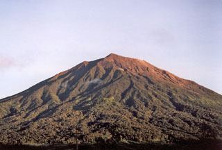
Geological Summary. Gunung Kerinci in central Sumatra forms Indonesia's highest volcano and is one of the most active in Sumatra. It is capped by an unvegetated young summit cone that was constructed NE of an older crater remnant. There is a deep 600-m-wide summit crater often partially filled by a small crater lake that lies on the NE crater floor, opposite the SW-rim summit. The massive 13 x 25 km wide volcano towers 2400-3300 m above surrounding plains and is elongated in a N-S direction. Frequently active, Kerinci has been the source of numerous moderate explosive eruptions since its first recorded eruption in 1838.
Information Contacts: Center of Volcanology and Geological Hazard Mitigation (CVGHM), Jalan Diponegoro 57, Bandung 40122, Indonesia (URL: http://www.vsi.esdm.go.id/); MODVOLC, Hawai'i Institute of Geophysics and Planetology (HIGP) Thermal Alerts System, School of Ocean and Earth Science and Technology (SOEST), Univ. of Hawai'i, 2525 Correa Road, Honolulu, HI 96822, USA (URL: http://modis.higp.hawaii.edu/).