Report on Rinjani (Indonesia) — January 2010
Bulletin of the Global Volcanism Network, vol. 35, no. 1 (January 2010)
Managing Editor: Richard Wunderman.
Rinjani (Indonesia) Thermal anomalies common during May-November 2009
Please cite this report as:
Global Volcanism Program, 2010. Report on Rinjani (Indonesia) (Wunderman, R., ed.). Bulletin of the Global Volcanism Network, 35:1. Smithsonian Institution. https://doi.org/10.5479/si.GVP.BGVN201001-264030
Rinjani
Indonesia
8.42°S, 116.47°E; summit elev. 3726 m
All times are local (unless otherwise noted)
In May and June 2009 (BGVN 34:06) the Center of Volcanology and Geological Hazard Mitigation (CVGHM) detected an increase in earthquakes and tremor, with eruptions from Barujari's cone within the Rinjani caldera. Later reports documented activity through August (BGVN 34:09).
In recent years thermal anomalies on the island had been seen (using MODVOLC data) only during September and October 2006 (2-3 days each month), September and October 2007 (1 day each), and August-October 2008 (1 day each). However, the 2009 eruption was clearly recorded. MODVOLC thermal alerts appeared frequently from May to October 2009, being detected on 17-25 days each month (table 4). Activity declined in November and December 2009, with no anomalies in January, but with alerts again seen on 4 and 18 February 2010.
Table 4. Number of days with MODVOLC thermal alerts at or near the Rinjani caldera, May 2009-February 2010. Courtesy of the Hawai'i Institute of Geophysics and Planetology (HIGP) Thermal Alerts System.
| Month | Days with thermal alerts |
| May 2009 | 18 |
| Jun 2009 | 25 |
| Jul 2009 | 24 |
| Aug 2009 | 23 |
| Sep 2009 | 19 |
| Oct 2009 | 17 |
| Nov 2009 | 9 |
| Dec 2009 | 6 |
| Jan 2010 | 0 |
| Feb 2010 | 2 |
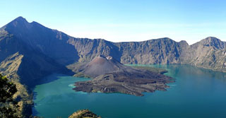
Geological Summary. Rinjani volcano on the island of Lombok rises to 3726 m, second in height among Indonesian volcanoes only to Sumatra's Kerinci volcano. Rinjani has a steep-sided conical profile when viewed from the east, but the west side of the compound volcano is truncated by the 6 x 8.5 km, oval-shaped Segara Anak (Samalas) caldera. The caldera formed during one of the largest Holocene eruptions globally in 1257 CE, which truncated Samalas stratovolcano. The western half of the caldera contains a 230-m-deep lake whose crescentic form results from growth of the post-caldera cone Barujari at the east end of the caldera. Historical eruptions dating back to 1847 have been restricted to Barujari cone and consist of moderate explosive activity and occasional lava flows that have entered Segara Anak lake.
Information Contacts: Center of Volcanology and Geological Hazards Mitigation (CVGHM), Jalan Diponegoro 57, Bandung 40122, Indonesia (URL: http://vsi.esdm.go.id/); Hawai'i Institute of Geophysics and Planetology (HIGP) Thermal Alerts System, School of Ocean and Earth Science and Technology (SOEST), Univ. of Hawai'i, 2525 Correa Road, Honolulu, HI 96822, USA (URL: http://modis.higp.hawaii.edu/).