Report on Karkar (Papua New Guinea) — May 2010

Bulletin of the Global Volcanism Network, vol. 35, no. 5 (May 2010)
Managing Editor: Richard Wunderman.
Karkar (Papua New Guinea) A plume in December 2009 and plumes on 26-27 February 2010
Please cite this report as:
Global Volcanism Program, 2010. Report on Karkar (Papua New Guinea) (Wunderman, R., ed.). Bulletin of the Global Volcanism Network, 35:5. Smithsonian Institution. https://doi.org/10.5479/si.GVP.BGVN201005-251030
Karkar
Papua New Guinea
4.647°S, 145.976°E; summit elev. 1839 m
All times are local (unless otherwise noted)
Plumes were reported from Karkar on 25-26 November 2009 (BGVN 34:11). Additional plumes were recognized in early December 2009 and during February 2010, but it was ambiguous whether these were ash-bearing plumes.
Rabaul Volcano Observatory (RVO) was unable to confirm that an eruption during 25 November to early December had occurred. In later fieldwork RVO found dead vegetation and noted that a few "holes" (small depressions) had developed in the crater area.
According to RVO, on 25-26 February local residents observed steam rising from inside the caldera and heard low roaring noises. Lightning was also observed above the summit area. The Darwin Volcanic Ash Advisory Center (VAAC) issued aviation reports on those dates noting that an ash plume rose to ~ 2.4 km and was blown as far as ~ 74 km NE and SE. Ultimately the plume was hidden by meteorological clouds.
Inferred debris-avalanche deposits and tsunami hazards. In a recent publication by Silver and others (2009), 12 debris avalanches were mapped in the Bismarck volcanic arc, including at Karkar (figure 8).
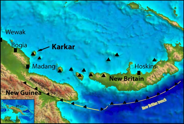 |
Figure 8. Location of Karkar and the broad-scale bathymetry of the Papua New Guinea region, showing the New Britain trench and its impingement on the main island of New Guinea as the Ramu-Markham fault. Index map appears at lower left. Map created using ERMapper. |
The authors used sidescan sonar (figure 9) and around Karkar found very high-amplitude reflectivity to the SW, indicating young lava flows. Adjacent to these flows are small regions of blocky backscatter, which the authors suggested were debris-avalanche deposits. Although these deposits are small, it is possible that they coalesce beneath the lava flows and have been buried by the younger activity. High-amplitude reflectivity also occurs on the N side of the volcano. Individual blocks are scattered, and the reflectivity pattern appears to result from both lava flows and small debris avalanches.
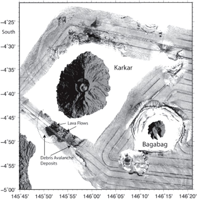 |
Figure 9. Detailed side-scan imagery of the seafloor around Karkar and nearby Bagabag. Dotted line surrounds the author's inferred debris avalanche deposit. 5' of latitude = 9.3 km. Bagabag, a Pleistocene-age volcano that lacks documented Holocene eruptions, sits ~ 20 km SE of Karkar. After Silver and others (2009). |
A subaerial landslide scar lies on Karkar's S side (figure 9). It could be associated with some of the debris imaged S of the volcano, although the available data came largely from transit lines and is incomplete. The authors state that, although the mapped extent of the debris avalanche deposit is small, it is still large enough to have produced a potentially significant tsunami in the Madang area.
Reference. Silver, E., Day, S., Ward, S., Hoffmann, G., Llanes, P., Driscoll, N., Appelgate, B., and Saunders, S., 2009, Volcano collapse and tsunami generation in the Bismarck Volcanic Arc, Papua New Guinea, J. of Volcanology and Geothermal Research, 186, 3-4, 210-222.
Geological Summary. Karkar is a 19 x 25 km forest-covered island that is truncated by two nested summit calderas. The 5.5 km outer caldera was formed during one or more eruptions, the last of which occurred 9,000 years ago. The steep-walled 300-m-deep, 3.2 km diameter, inner caldera was formed sometime between 1,500 and 800 years ago. Cones are present on the N and S flanks of this basaltic-to-andesitic volcano; a linear array of small cones extends from the northern rim of the outer caldera nearly to the coast. Recorded eruptions date back to 1643 from Bagiai, a pyroclastic cone constructed within the inner caldera, the floor of which is covered by young, mostly unvegetated andesitic lava flows.
Information Contacts: Rabaul Volcano Observatory (RVO), PO Box 386, Rabaul, Papua New Guinea; Department of Mineral Policy & Geohazards Management, P.O. Box 3386, Kokopo, East New Britain Province, Papua New Guinea, Volcanological Observatory Geohazards Management Division; Darwin Volcanic Ash Advisory Centre (VAAC), Bureau of Meteorology, Northern Territory Regional Office, PO Box 40050, Casuarina, NT 0811, Australia (URL: http://www.bom.gov.au/info/vaac/).