Report on Gaua (Vanuatu) — May 2010
Bulletin of the Global Volcanism Network, vol. 35, no. 5 (May 2010)
Managing Editor: Richard Wunderman.
Gaua (Vanuatu) Significant emissions of gas and ash through 19 June 2010
Please cite this report as:
Global Volcanism Program, 2010. Report on Gaua (Vanuatu) (Wunderman, R., ed.). Bulletin of the Global Volcanism Network, 35:5. Smithsonian Institution. https://doi.org/10.5479/si.GVP.BGVN201005-257020
Gaua
Vanuatu
14.281°S, 167.514°E; summit elev. 729 m
All times are local (unless otherwise noted)
Beginning in September 2009, eruptions at Gaua included emissions with heavy ashfall, a small pyroclastic flow, and strong Strombolian activity. Eruptions were also accompanied by strong and continuous degassing, and elevated SO2 levels (BGVN 34:10 and 34:12).
The previous report discussed activity through 1 February 2010. This report covers activity between 2 February 2010 and 19 June 2010. However, no information was available for February or March from the Vanuatu Geohazards Observatory (VGO). Satellite thermal alerts from the MODVOLC system occurred on 28 March and 6 April (both one pixel).
In early April 2010 activity increased. The VGO reported that the ash plumes became thicker and higher (figure 17) and rose daily to altitudes of 2.1-3 km. Starting on 3 April, villagers living in the N and S parts of the island reported ashfall and frequently saw volcanic bombs ejected. Explosions were heard in nearby villages. Tremor counts after 1 January 2010 increased with time at least through 7 May (figure 18).
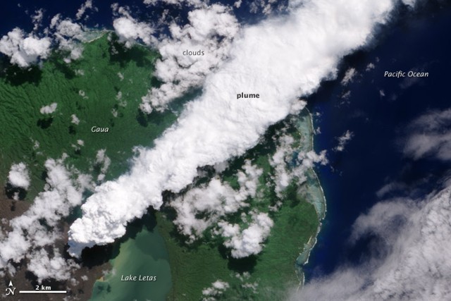 |
Figure 17. Satellite image of a dense steam-rich ash plume from Guau blowing directly NE on 24 April 2010. The steam is brighter white than the surrounding lower-altitude clouds. Vegetation is green, as is Lake Letas. Vegetation to the S and W of the volcano, damaged by ash and acidic volcanic gases, is dark gray-brown. Image taken by the Advanced Land Imager aboard NASA's Earth Observing-1 (EO-1) spacecraft. Courtesy NASA Earth Observatory. |
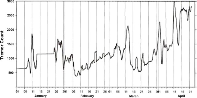 |
Figure 18. Tremor counts at Gaua between 1 January 2010 and about 22 April 2010. Courtesy of VGO. |
According to a 21 April news account the Red Cross disaster management officer in Vanuatu, Augustin Garae, told Radio New Zealand International that the fumes and ashfall had become a health hazard, with ash and acid rain affecting food crops and contaminating the water. News media on 19 April reported that Vanuatu government officials had made preparations to evacuate the approximately 3,000 residents of Gaua Island, who were threatened by ash, poisonous gases, and landslides.
On 11 May, the VGO reported that field observations revealed continued activity during April through the beginning of May. Significant emissions of gas and ash caused damage to vegetation around the crater and in areas on the NW, W, and SW parts of the island, the dominant wind directions. Lahars on the W part of the island were seen in April. Seismic data revealed that tremors had become more frequent since the beginning of the year. The VGO has advised visitors to stay away from the restricted area, especially within 3 km zone around the volcano.
Based on information from the VGO and satellite imagery, the Wellington VAAC reported ash plumes from Gaua on 8-16 April, 19-21 April, 29 April, 2 May, 11 May, 18-19 May, 21-22 May, 26 May, 7 June, and 16-19 June that all rose to an altitude of 3 km. On 19 June, the plume drifted more than 90 km W. The advisories on 14-15 April noted that the plumes were mostly steam. A spokesman for the Vanuatu Disaster Management Office described the activity as "huge, dark plumes" in a news report.
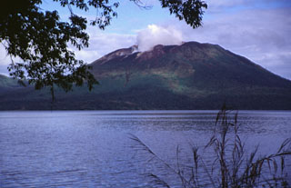
Geological Summary. The roughly 20-km-diameter Gaua Island, also known as Santa Maria, consists of a basaltic-to-andesitic stratovolcano with an 6 x 9 km summit caldera. Small vents near the caldera rim fed Pleistocene lava flows that reached the coast on several sides of the island; littoral cones were formed where these lava flows reached the ocean. Quiet collapse that formed the roughly 700-m-deep caldera was followed by extensive ash eruptions. The active Mount Garet (or Garat) cone in the SW part of the caldera has three pit craters across the summit area. Construction of Garet and other small cinder cones has left a crescent-shaped lake. The onset of eruptive activity from a vent high on the SE flank in 1962 ended a long period of dormancy.
Information Contacts: E. Garaebiti, S. Todman, C. Haruel, D. Charley, D. Nakedau, J. Cevuard, and A. Worwor, Vanuatu Geohazards Observatory (VGO), Department of Geology, Mines and Water Resources (DGMWR), Vanuatu (URL: http://www.vmgd.gov.vu/vmgd/); Wellington Volcanic Ash Advisory Centre, Meteorological Service of New Zealand Limited, 30 Salamanca Road, Kelburn, PO Box 722, Wellington, New Zealand (URL: http://vaac.metservice.com/vaac/); Hawai'i Institute of Geophysics and Planetology (HIGP) Thermal Alerts System, School of Ocean and Earth Science and Technology (SOEST), Univ. of Hawai'i, 2525 Correa Road, Honolulu, HI 96822, USA (URL: http://modis.higp.hawaii.edu/); Sydney Morning Herald (URL: http://news.smh.com.au/); Radio New Zealand International (URL: http://www.rnzi.com/).