Report on Kawio Barat (Indonesia) — June 2010

Bulletin of the Global Volcanism Network, vol. 35, no. 6 (June 2010)
Managing Editor: Richard Wunderman.
Kawio Barat (Indonesia) Hydrothermal activity at 3-km-high submarine volcano in the Sangihe arc
Please cite this report as:
Global Volcanism Program, 2010. Report on Kawio Barat (Indonesia) (Wunderman, R., ed.). Bulletin of the Global Volcanism Network, 35:6. Smithsonian Institution. https://doi.org/10.5479/si.GVP.BGVN201006-267090
Kawio Barat
Indonesia
4.675°N, 125.088°E; summit elev. -1874 m
All times are local (unless otherwise noted)
Marine exploration revealed a ~3-km-tall submarine volcano called Kawio Barat (or West Kawio) that displayed hydrothermal venting, sulfur deposits, and communities of organisms. The summit, at a depth of ~ 2 km in water depths of ~ 5.5 km, sits ~ 45 km W of the Kawio Islands and just W of the Sangihe arc (figure 1). The National Oceanic and Atmospheric Administration (NOAA) reported this research on its Ocean Explorer website (Malik and others, 2010).
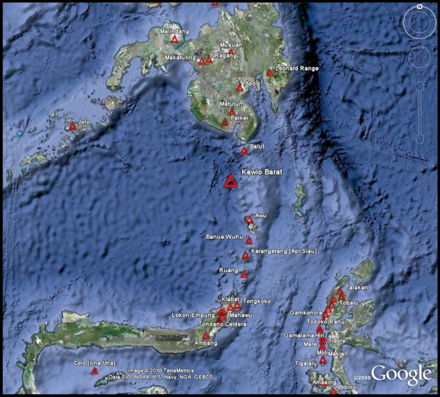 |
Figure 1. Google Earth map of the Sangihe arc showing the location of Kawio Barat. Volcanoes of the arc active within the previous 100 year include Ruang, Karangetang (Api Siau), Banua Wuhu, and Awu. |
On 26 June 2010, a joint Indonesia-U.S. team explored the ocean N of Sulawesi aboard a NOAA ship, the Okeanos Explorer. Scientists used multibeam sonar to map the sea floor (figure 2) and cameras on remotely-operated vehicles (ROVs) to take photographs. The Ocean Explorer website includes logs from scientists at sea and ashore, as well as images and videos from the expedition.
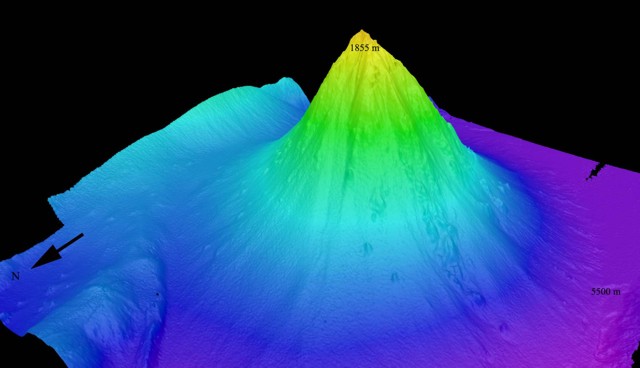 |
Figure 2. Perspective view, created from bathymetric data collected on 26 June 2010, of the Kawio Barat seamount looking from the NW. The sea floor is shown to be at a depth of 5,500 m and the summit at a depth of 1,855 m. Vertical exaggeration was not disclosed. Courtesy of NOAA Ocean Explorer. |
The Little Hercules ROV filmed video on 29 June 2010 during the vehicle's second dive on Kawio Barat, which is available on both the Ocean Explorer website (30 June 2010 log) and the National Geographic website. During the ROV's descent to the location where plumes were discovered the previous day, it encountered white plumes of warm sulfur-rich water (figure 3) and followed the plumes to their source vents. The volcanic rocks surrounding the vents were covered in white sulfur. Images revealed both yellow and black solidified flows of sulfur, the color being an indication of the molten sulfur's temperature when extruded. The sulfur deposits were home to shrimp and limpets that were thought to feed on the bacteria known to thrive in such settings.
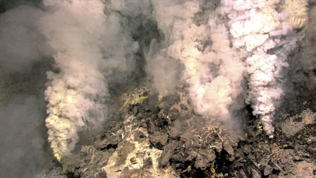 |
Figure 3. Image from the Little Hercules ROV of a vent plume at the summit of Kawio Barat submarine volcano on 30 June 2010. Courtesy of National Geographic. |
Hydrothermal vents often emit high levels of aqueous sulfur. The video shows another hydrothermal area with a very dense population of stalked barnacles. These vent barnacles seemingly have filaments of bacteria growing on their feeding appendages; they retract the appendages to feed on the filaments. Along with the barnacles, imagery disclosed a field of sulfide chimneys, presumably precipitating from the hot, mineralized vent fluids as they cooled and mixed with seawater.
Reference. Malik, M., Lobecker, E., Stuart, E., Peters, C., and Verplanck, N., 2010, NOAA Ship Okeanos Explorer maps Kawio Barat, latitude: 4.6449°N, longitude: 125.03°E, NOAA Ocean Explorer website (http://oceanexplorer.noaa.gov/okeanos/explorations/10index/logs/june26/june26.html).
Geological Summary. The conical Kawio Barat submarine volcano sits just W of the Sangihe volcanic arc between Sulawesi Island in Indonesia and Mindanao Island in the Philippines. Satellite imagery showed submarine vents generating visible hydrothermal activity on the W side of the arc. A detailed survey was conducted in June 2010.
Information Contacts: National Oceanic and Atmospheric Administration (NOAA) Ocean Explorer (http://oceanexplorer.noaa.gov/okeanos/explorations/10index/); NOAA News (URL: http://www.noaanews.noaa.gov/stories2010/20100712_underwatervolcano.html); National Geographic (URL: http://www.nationalgeographic.com/).