Report on Rinjani (Indonesia) — September 2010
Bulletin of the Global Volcanism Network, vol. 35, no. 9 (September 2010)
Managing Editor: Richard Wunderman.
Rinjani (Indonesia) Seismicity declined significantly in 2010
Please cite this report as:
Global Volcanism Program, 2010. Report on Rinjani (Indonesia) (Wunderman, R., ed.). Bulletin of the Global Volcanism Network, 35:9. Smithsonian Institution. https://doi.org/10.5479/si.GVP.BGVN201009-264030
Rinjani
Indonesia
8.42°S, 116.47°E; summit elev. 3726 m
All times are local (unless otherwise noted)
Thermal anomalies on Rinjani island previously reported (BGVN 35:01) continue to be recorded by MODIS and caused alerts on the MODVOLC system. Between 1 January and 26 November 2010, MODVOLC thermal alerts occurred on 4, 18, and 27 February, 11 and 29 April, and 1 and 20 May. On 18 February, 9 and 22 pixels were recorded by the Terra and Aqua satellites, respectively.
The Center of Volcanology and Geological Hazard Mitigation (CVGHM) reported variable seismic activity during February-April 2010 (table 5), with "white to brown" emissions reaching 50-1500 m above the crater; the number of emissions increased each month, with 1, 26, and 41 emissions reported during February, March, and April, respectively.
Table 5. Summary of seismic events recorded at Rinjani, February-April 2010. Courtesy of CVGHM.
| Date | Eruption EQ | Tremor | Tremor EQ | Low-frequency EQ | Volcanic EQ | Shallow volcanic EQ |
| Feb 2010 | 177 | 20 | 151 | 16 | 3 | 23 |
| Mar 2010 | 114 | 14 | 186 | 23 | 14 | 5 |
| Apr 2010 | 93 | 10 | 72 | 9 | 30 | 10 |
During 1-2 May, 4-6 eruption earthquakes were registered each day, and dense brown emissions reached 900-1600 m above the crater.
The Darwin Volcanic Ash Advisory Centre reported that, on 5 May, a possible ash plume from Rinjani rose to an altitude of 5.5 km and drifted 150 km NW.
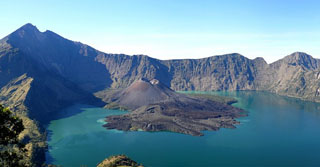
According to news articles, three eruptions from Rinjani during 22-23 May were accompanied by tremors. Ash and incandescent material was ejected as high as 2 km above the caldera. Plumes drifted 12 km and caused ashfall in multiple areas covering hectares of cropland. Lava flowed into the Segara Anak lake, which lies within the main caldera and caused the lake water temperature to rise from 21° to 35°C. Eruptions were not considered to be at a dangerous level, and evacuations were not ordered.
CVGHM reported that, during June through mid-November, seismicity from Rinjani decreased; visual observations indicated no activity since August. On 19 November, the alert level was lowered to 1 (normal, on a scale of 1-4).
Geological Summary. Rinjani volcano on the island of Lombok rises to 3726 m, second in height among Indonesian volcanoes only to Sumatra's Kerinci volcano. Rinjani has a steep-sided conical profile when viewed from the east, but the west side of the compound volcano is truncated by the 6 x 8.5 km, oval-shaped Segara Anak (Samalas) caldera. The caldera formed during one of the largest Holocene eruptions globally in 1257 CE, which truncated Samalas stratovolcano. The western half of the caldera contains a 230-m-deep lake whose crescentic form results from growth of the post-caldera cone Barujari at the east end of the caldera. Historical eruptions dating back to 1847 have been restricted to Barujari cone and consist of moderate explosive activity and occasional lava flows that have entered Segara Anak lake.
Information Contacts: Center of Volcanology and Geological Hazard Mitigation (CVGHM), Jalan Diponegoro 57, Bandung 40122, Indonesia (URL: http://vsi.esdm.go.id/); Hawai'i Institute of Geophysics and Planetology (HIGP) Thermal Alerts System, School of Ocean and Earth Science and Technology (SOEST), Univ. of Hawai'i, 2525 Correa Road, Honolulu, HI 96822, USA (URL: http://modis.higp.hawaii.edu/); Darwin Volcanic Ash Advisory Centre (VAAC), Bureau of Meteorology, Northern Territory Regional Office, PO Box 40050, Casuarina, NT 0811, Australia (URL: http://www.bom.gov.au/info/vaac/); RTT News (URL: http://www.abc.net.au/).