Report on Sheveluch (Russia) — November 2010
Bulletin of the Global Volcanism Network, vol. 35, no. 11 (November 2010)
Managing Editor: Richard Wunderman.
Sheveluch (Russia) Unrest continued during 2010; strong eruption on 28 October 2010
Please cite this report as:
Global Volcanism Program, 2010. Report on Sheveluch (Russia) (Wunderman, R., ed.). Bulletin of the Global Volcanism Network, 35:11. Smithsonian Institution. https://doi.org/10.5479/si.GVP.BGVN201011-300270
Sheveluch
Russia
56.653°N, 161.36°E; summit elev. 3283 m
All times are local (unless otherwise noted)
Our last report (BGVN 35:03) described activity at Shiveluch during from May 2008 through March 2010. This report describes unrest that continued from April through December 2010, characterized by above-background or moderate seismicity, a large daily thermal anomaly from the lava dome detected in satellite imagery, and ash plumes observed throughout the reporting period (figure 23). During this time period, an explosive eruption from the growing lava dome started on 28 October 2010 at about 0200, based on seismic data (local time and date). The eruption generated significant ash plumes as well as pyroclastic flows. A table below delineates the thermal anomalies and summarizes behavior during October through December 2010, approximately from the eruption onwards (table 9).
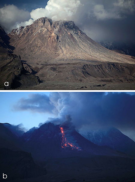 |
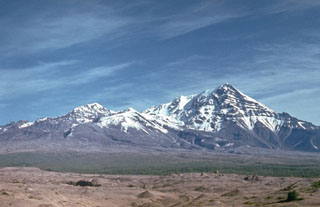
Figure 23. Images of Shiveluch taken 23 June 2010 both (a) during the day and (b) at night. Photo by Yuri Demyanchuk. |
Table 9. The activity of Shiveluch during 28 October-15 November 2010. Courtesy of the Kamchatka Branch of the Geophysical Service, Russian Academy of Sciences (KB GS RAS).
| Date | Thermal anomaly, number of pixels | Ash clouds, plume (from AVO) |
| 27 Oct 2010 | -- | Ash cloud 10 km above see level and 20 km in length; A dense plume extending 360 km to SE. |
| 28 Oct 2010 | 7 | Ash plume extending 1 500 km SE. |
| 29 Oct 2010 | -- | A dense ash plume extending 165 km E and a more diffuse plume extending 1 132 km to E. |
| 30 Oct 2010 | 5 | A dense plume extending 361 km to SE and a more diffuse plume extending 404 km to SE. |
| 31 Oct 2010 | -- | A dense plume extending 270 km to SE and more diffuse plume extending 390 km to SE. |
| 01 Nov 2010 | 10 | A dense plume extending 300 km to SE. |
| 03 Nov 2010 | 3 | -- |
| 04 Nov 2010 | 9 | A dense plume extending 260 km to SW and two diffuse plumes extending 260 km SE and 160 km SE. |
| 06 Nov 2010 | 19 | -- |
| 07 Nov 2010 | 10 | A diffuse plume extending 48 km to SE. |
| 08 Nov 2010 | 5 | A dense plume extending 63 km to SW. |
| 09 Nov 2010 | 8 | A dense plume extending 20 km to SE. |
| 10 Nov 2010 | 4 | Ash plume 4.8 km altitude extending 1 km to E. |
| 11 Nov 2010 | 4 | -- |
| 12 Nov 2010 | 2 | -- |
| 13 Nov 2010 | 2 | A dense plume extending 52 km to NW. |
| 14 Nov 2010 | 5 | -- |
| 16 Nov 2010 | 4 | Steam emission 1 km to W. |
| 17 Nov 2010 | 4 | Steam emission 600 m to NW. |
| 18 Nov 2010 | 7 | Steam emission 700 m. |
| 19 Nov 2010 | 10 | Ash plume extending 20 km to E. |
| 20 Nov 2010 | 4 | Ash plume extending 20 km to E. |
| 21 Nov 2010 | 6 | -- |
| 22 Nov 2010 | 8 | Ash plume about 1.5 km altitude. |
| 24 Nov 2010 | 6 | Hot avalanches. |
| 26 Nov 2010 | 7 | Moderate steam emission to NE. |
| 01 Dec 2010 | 7 | -- |
| 03 Dec 2010 | 4 | Ash plume extending 322 km to SE. |
| 05 Dec 2010 | 3 | -- |
| 06 Dec 2010 | 2 | -- |
| 07 Dec 2010 | 4 | -- |
| 10 Dec 2010 | 3 | -- |
| 11 Dec 2010 | 3 | -- |
| 12 Dec 2010 | 2 | -- |
| 13 Dec 2010 | 4 | -- |
| 14 Dec 2010 | 3 | Ash clouds to 4.5 km altitude blowing NE. Avalanche with runout distance of 2 km going SSE. |
| 18 Dec 2010 | 4 | -- |
| 19 Dec 2010 | 3 | -- |
| 20 Dec 2010 | 2 | -- |
| 22 Dec 2010 | 4 | -- |
| 23 Dec 2010 | 4 | Moderate steam emission to W. |
| 24 Dec 2010 | 2 | Ash cloud 4.5 km altitude. |
| 27 Dec 2010 | 7 | -- |
| 28 Dec 2010 | 2 | -- |
| 29 Dec 2010 | 3 | -- |
| 30 Dec 2010 | 3 | -- |
| 31 Dec 2010 | 2 | Moderate steam emission. |
Prior to the large explosion of 28 October, behavior was characterized by the growing lava dome generating strong or weak gas-steam emissions, and explosions of different intensity that sometimes produced hot avalanches. Notably, on 1 July 2010 seismicity increased. Not long afterwards in Klyuchi village (50 km SW from volcano) residents saw ash falling, material they described as reddish in color.
During July to September 2010, KVERT reported that analyses of satellite imagery showed a large daily thermal anomaly over the lava dome. Seismic activity remained above background levels suggesting that on most days there were possible ash plumes. Ash and gas plumes, or the combination of the two, rose to altitudes between 3.5 and 8.5 km and drifted in multiple directions as far as 190 km from the volcano. Ash plumes that were possibly generated by hot avalanches rose to altitudes up to 4.5 km the latest being observed July 5.
Both Shiveluch and Kliuchevskoi volcanoes often produce ash plumes and this was the case both before and during the 28 October eruption at Shiveluch. Prior to the eruption a 29 September 2010 image of Shiveluch and neighboring Kliuchevskoi showed SE-trending plumes from each. The plume from Shiveluch was described on the NASA Earth Observatory website and as "thin"; the one for Kliuchevskoi was described as "wider and more diffuse." In a later (post-eruption) report, Earth Observatory discussed Shiveluch's 28 October plume, which appeared moderately dense and light brown on a natural color satellite image. Visible on the same image, Kliuchevskoi also discharged a small dense plume.
Seismicity increased on 27 October, then the number of local earthquakes and the tremor magnitude both increased sharply starting about 0200 on 28 October. This seismicity disclosed a strong explosive eruption that was soon confirmed by other observations. The NOAA-16 satellite data collected at 0809 on the 28th indicated a dark E-trending ash plume that obscured Ust-Kamchatsk village (population, 5,000) located 85 km SE of Shiveluch. In that village, the local visibility went down to ~5 m and several centimeters of ash ultimately fell. Conditions closed roads and drove residents indoors where they waited out the event with tightly closed doors and windows.
Figure 2 shows processed satellite imagery of an extensive ash cloud E of Shiveluch late on 27 October (local time and date). Relevant to figure 24, the GOES-R algorithm uses spectral channels that are available on both MODIS and GOES-R satellites. Thus, in the sense of a volcanic ash retrieval algorithm, MODIS satellites are a good proxy for GOES-R (figure 24).
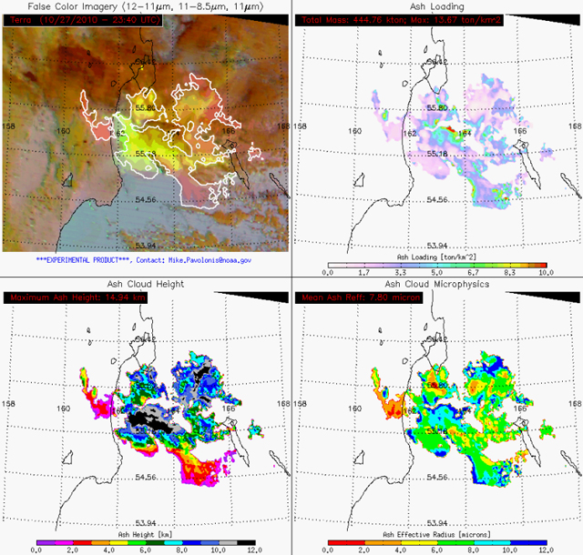 |
Figure 24. A set of satellite images that estimate the Shiveluch ash cloud in terms of the following (clockwise from upper left) extent (false-color), ash loading (metric tons/km2), ash reflectivity (effective radius of ash particles), and heights of cloud tops. According to the GOES-R infrared ash retrieval algorithm (using MODIS as a proxy for GOES-R), the cloud had a local maximum height of around 15 km altitude, with values in the 10-13 km being more common in the high part of the cloud. The image was captured by the MODIS Terra satellite at 2340 on 27 October (UTC time and date; this corresponds to 1140 on 28 October local time and date in Kamchatka, about 10 hours after the seismically determined eruption onset). This set of images are an experimental product produced by Mike Pavolonis (NOAA/NESDIS/STAR). |
Figure 3 shows a photo of the resultant brownish-gray ash-fall deposit on the ash-capped snow.
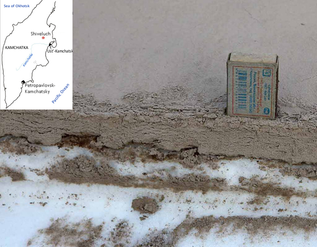 |
Figure 25. Ash deposited on snow typically reached 2.5-3 cm thick in Ust-Kamchatsk village after the 28 October 2010 eruption. The ash layer is on the snow surface (lower ash layers and lenses seen on this cut section represent artifacts produced by digging down through the snow; ~5-cm-tall matchbox for scale). Photo courtesy of Yuri Demyanchuk. |
By the end of the 28th, satellite images showed ash clouds near and over the volcano that had a width of ~20 km and a cloud-top altitude of about 10-15 km (the 15 km estimate, higher than most, was from experimental work by Mike Pavolinis, figure 24). Satellite imagery followed the plume as it drifted across the North Pacific visible for at least 1,500 km SE.
Volcanic Ash Graphics such as the one on figure 4 were sent to the aviation community to help aviators respond to the threat of ash at high altitudes and along airways (flight routes).
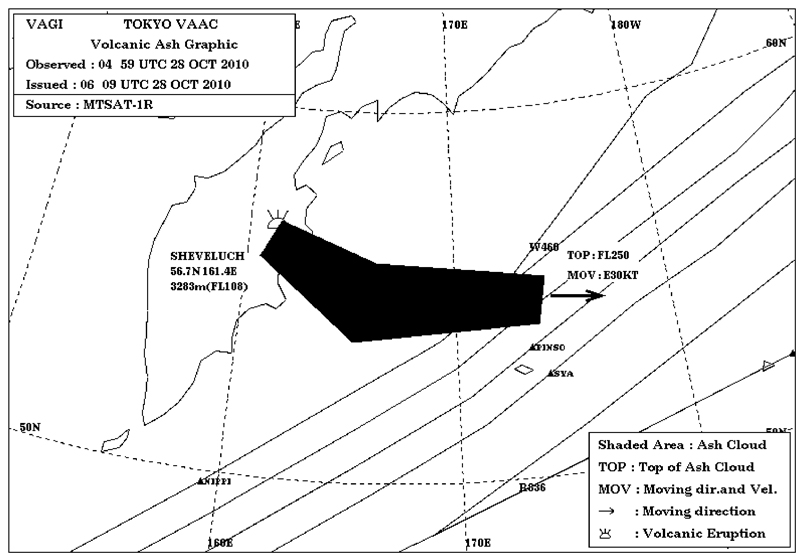 |
Figure 26. A Volcanic Ash Graphic (VAG) issued by the Tokyo Volcanic Ash Advisory Center (VAAC) at stated date and time on 28 October 2010 (UTC). The product is intended to help aviators forsee hazardous ash in the atmosphere (black area). The analysis was based on MTSAT-1R but may have included other data and modeling. The text on the graphic indicates the cloud top, FL250 (25,000 ft., ~7 km altitude), and velocity (moving E at 30 knots, ~54 km/hr). The sub-parallel lines trending roughly NE are the common aviation routes (airways) over the region. This topic is discussed further in the Ekarma report in this issue (BGVN 35:11). Courtesy of the Tokyo VAAC. |
According to a KVERT report, ash plumes rose up to 7 km at 0600 on 29 October. Ash continued to fall in Ust-Kamchatsk that same day.
Explosions continued on 30 October. Weather conditions prevented initial visible and satellite observations of the eruption, but seismic data suggested that ash plumes rose to an altitude of ~10 km and drifted NE. Based on analyses of satellite imagery and information from KVERT, the Tokyo VAAC reported that possible eruptions on 31 October and during 1-2 November produced ash plumes that rose to altitudes of 3.7-6.7 km and drifted SE and E. Subsequent notices on 31 October and 1 November stated that ash had dissipated.
News reported by The Boston Globe noted the eruptions had complicated air travel in the area of the Kamchatkan Peninsula. According to this news source, several pilots reported seeing ash clouds in the Alaskan region, but it was below 25,000 ft (7.6 km), too low to present problems to aircraft at cruising altitudes. The Aviation Hazard Status reached Red, the highest level, during 28-31 October 2010.
Geological Summary. The high, isolated massif of Sheveluch volcano (also spelled Shiveluch) rises above the lowlands NNE of the Kliuchevskaya volcano group. The 1,300 km3 andesitic volcano is one of Kamchatka's largest and most active volcanic structures, with at least 60 large eruptions during the Holocene. The summit of roughly 65,000-year-old Stary Shiveluch is truncated by a broad 9-km-wide late-Pleistocene caldera breached to the south. Many lava domes occur on its outer flanks. The Molodoy Shiveluch lava dome complex was constructed during the Holocene within the large open caldera; Holocene lava dome extrusion also took place on the flanks of Stary Shiveluch. Widespread tephra layers from these eruptions have provided valuable time markers for dating volcanic events in Kamchatka. Frequent collapses of dome complexes, most recently in 1964, have produced debris avalanches whose deposits cover much of the floor of the breached caldera.
Information Contacts: Kamchatka Volcanic Eruptions Response Team (KVERT), Far East Division, Russian Academy of Sciences, 9 Piip Blvd., Petropavlovsk-Kamchatsky, 683006, Russia (URL: http://www.kscnet.ru/ivs/); Yuri Demyanchuk, IVIS FED RAS; NASA Earth Observatory; Michael J. Pavolonis, US National Oceanographic and Atmospheric Administration, Satellites and Information, National Environmental Satellite, Data, and Information Service (NOAA/NESDIS); Center for Satellite Applications and Research (STAR)], 1225 W. Dayton St., Madison, WI 53706; Tokyo Volcanic Ash Advisory Centre (VAAC), Tokyo, Japan (URL: http://ds.data.jma.go.jp/svd/vaac/data/)