Report on Bulusan (Philippines) — March 2011

Bulletin of the Global Volcanism Network, vol. 36, no. 3 (March 2011)
Managing Editor: Richard Wunderman.
Bulusan (Philippines) Earthquakes and explosions during 6 November 2010-early March 2011
Please cite this report as:
Global Volcanism Program, 2011. Report on Bulusan (Philippines) (Wunderman, R., ed.). Bulletin of the Global Volcanism Network, 36:3. Smithsonian Institution. https://doi.org/10.5479/si.GVP.BGVN201103-273010
Bulusan
Philippines
12.769°N, 124.056°E; summit elev. 1535 m
All times are local (unless otherwise noted)
The current report describes activity at Bulusan during 2008 through early March 2011, an interval punctuated by seismic signals indicative of explosions and occasional cases where ash fell up to 70 km away. During 2007, there were explosions, ash and steam plumes, and some ground inflation (BGVN 33:02).
Quiet during 2008 through October 2010. According to the Philippine Institute of Volcanology and Seismology (PHIVOLCS), seismic events were infrequent after the middle of 2008 through 2009. In addition, ground deformation surveys in 2009 showed deflation of the volcanic edifice. These observations were indicative of a decline in the overall activity of the volcano. Thus, the Alert Level was lowered from 1 to 0 (out of 5) on 15 May 2009. Maps appear below (figures 8 and 9).
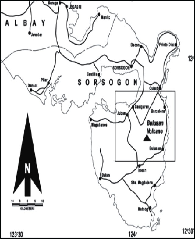 |
Figure 8. Index map of Bulusan, a large stratovolcano located on the S portion of Luzon Island (Philippines). Courtesy of PHIVOLCS. |
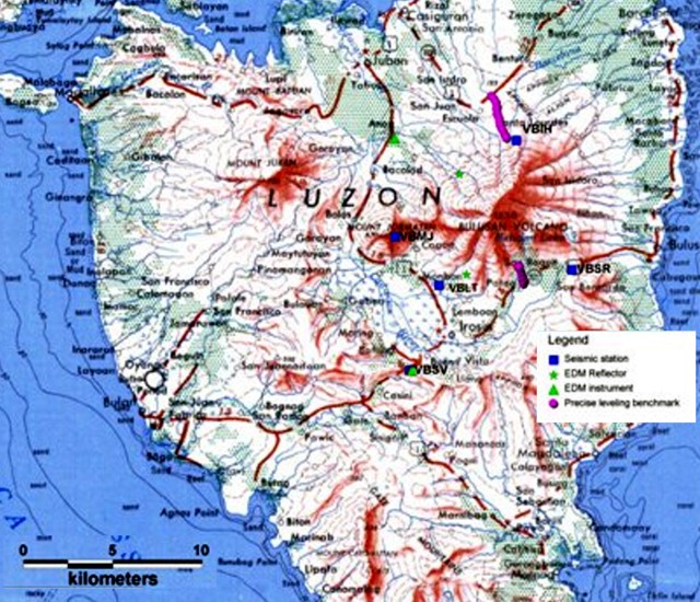 |
Figure 9. Map showing monitoring network at Bulusan. Equipment includes seismic instruments (4 stations), EDM surveying instruments and reflectors, and benchmarks for precise leveling traverses (N and S flanks of volcano). Courtesy of PHIVOLCS. |
Quiet ends in November 2010. A volcanic, explosion-type earthquake occurred on 6 November 2010 coincident with a steam-and-ash plume that rose 600 m above the crater. Trace amounts of ashfall were reported in multiple areas 6-10 km NW. The Alert Level was raised from 0 to 1, and PHIVOLCS reminded the public not to enter the permanent danger zone, defined as a 4-km radius around the volcano.
After 6 November and during late 2010 to early 2011, Bullusan experienced a number of earthquakes (table 5), and steam was often observed rising from the crater and known thermal vents, especially after an explosion. However, cloud cover frequently obscured the summit area. The Tokyo Volcanic Ash Advisory Center (VAAC) occasionally reported the presence of ash plumes (table 6).
Table 5. Earthquakes at Bulusan recorded by the seismic network between 1 November 2010-8 March 2011. Based on reports from PHIVOLCS.
| Date | Number of earthquakes | Type of earthquake |
| 06 Nov 2010 | 1 | Explosion-type |
| 10-11 Nov 2010 | 18 | Volcanic-tectonic |
| 12 Nov 2010 | 4 | Volcanic-tectonic |
| 21 Nov 2010 | 1 | Explosion-type |
| 26 Nov 2010 | 1 | Explosion-type |
| 01-06 Dec 2010 | Detected | Volcanic |
| 08-12 Dec 2010 | 40544 | Volcanic |
| 13 Dec 2010 | 7 | Volcanic |
| 23 Dec 2010 | 1 | Explosion-type |
| 30-31 Dec 2010 | 8 | Volcanic-tectonic |
| 04-10 Jan 2011 | 2-8 daily | Volcanic |
| 11-17 Jan 2011 | Up to 2 daily | Volcanic |
| 18-19 Jan 2011 | 11 | Volcanic |
| 20-27 Jan 2011 | Up to 5 daily | Volcanic |
| 29-30 Jan | Up to 5 daily | Volcanic |
| 17-20 Feb 2011 | Up to 3 daily | Volcanic |
| 21-22 Feb 2011 | 16 | Volcanic |
| 24 Feb-01 Mar 2011 | Up to 5 daily | Volcanic |
| 02-08 Mar 2011 | Up to 4 daily | Volcanic |
Table 6. Volcanic ash emissions from Bulusan during 6 November 2010-26 March 2011. Based on reports from the Tokyo VAAC. The line indicated by "x" refers to an ash plume that was reported to authorities but not identifiable on imagery.
| Date | Altitude (km) | Plume direction |
| 06 Nov 2010 | 2.4 | SW |
| 08 Nov 2010 | 2.4 | -- |
| 09 Nov 2010 | 2.7 | SW |
| 12 Nov 2010 | 2.4 | -- |
| 21 Nov 2010 | 3.7 | SW |
| 24 Nov 2010 | 2.7 | SW |
| 25 Nov 2010 | 2.1 | -- |
| 16 Dec 2010 | 2.1 | SW |
| 23 Dec 2010 | 2.1 | S |
| 24 Dec 2010 | 2.1 | SW |
| 29 Dec 2010 | x | -- |
| 30 Dec 2010 | x | -- |
| 05 Jan 2011 | x | -- |
| 06 Jan 2011 | x | -- |
| 07 Jan 2011 | x | -- |
| 14 Jan 2011 | x | -- |
| 04 Feb 2011 | x | -- |
| 21 Feb< 2011/td>3.7 -4.9W | ||
| 22 Feb 2011 | x | -- |
| 24 Feb | x | -- |
| 26 Feb 2011 | x | -- |
| 27 Feb 2011 | x | -- |
| 28 Feb 2011 | x | -- |
| 03 Mar 2011 | x | -- |
| 04 Mar 2011 | x | -- |
| 18 Mar 2011 | x | -- |
| 20 Mar 2011 | x | -- |
| 25 Mar 2011 | x | -- |
| 26 Mar 2011 | x | -- |
On 7 November, PHIVOLCS noted that seismic activity had increased during the previous 24 hours. A phreatic explosion on 8 November produced a brownish-to-light-gray plume that rose 700 m above the crater. Several neighborhoods to the NW, W, and WSW reported ashfall. Steam rose from the crater after the explosion. On 9 November two consecutive ash explosions, accompanied by rumbling sounds, produced ash plumes that rose as high as 1 km above the crater and drifted SW. Ashfall up to 2 mm thick was reported in areas to the SW and WNW.
On 11 November 2010, white steam plumes rose 150 m above the crater and drifted ENE. An aerial survey noted that recent explosions resulted in the joining of two of the 2006-2007 craters into one. PHIVOLCS scientists also found that deposits from an explosion on 9 November did not contain juvenile material. On 12 November an ash explosion produced an ash-and-steam plume that rose 700 m above the crater and drifted SW. Multiple neighborhoods to the W and SW reported light ashfall. During 12-14 November, some steaming from the crater was observed. An explosion late at night on 15 November was followed by ashfall in nearby neighborhoods.
An explosion earthquake on 21 November 2010 was coincident with rumbling sounds and an ash plume that rose 2 km above the crater. Ashfall up to 3 mm thick was reported in multiple areas. According to news reports (Philippine Daily Inquirer), about 500 families evacuated and some local roads were impassable.
On 24 November 2010, PHIVOLCS reported that an explosion, recorded for almost six minutes by seismographs, produced an ash plume that rose 1 km above the crater, drifted SW, and dissipated. Ashfall was not observed outside of the permanent danger zone, defined as a 4-km radius from the summit, suggesting that ashfall was confined to the upper flanks. On 26 November, an explosion-type earthquake was recorded.
On 17 December 2010, PHIVOLCS reported that an explosion, recorded for about 3 minutes by seismographs, produced an ash-and-steam plume that rose 500 m above the crater and drifted SW. Another explosion on 23 December followed tremor that lasted for almost 31 minutes. A grayish steam-and-ash plume rose to about 500 m above the crater rim and drifted S-SW.
Seismic activity continued into 2011 with volcanic earthquakes, frequent steam emissions, and an occasional explosion. Tokyo VAAC reported ash plumes from Bulusan, although cloud cover frequently obscured the summit area.
An explosion on 18 January 2011 was accompanied by a rumbling sound audible in Monbon, a barangay (neighborhood) in the municipality of Irosin, 6 km to the SW. Trace amounts of ashfall were observed in Monbon. A deformation survey conducted during 25-29 January showed slight deflation relative to a December 2010 survey.
An explosion on 21 February 2011 produced a gray ash plume that rose ~3 km above the crater and drifted SW. Rumbling sounds were heard up to 10 km away in the town of Juban (NW). The event was recorded by the seismic network as an explosion-type earthquake lasting for about 19 minutes. Field investigations confirmed ash deposits in the towns of Irosin (up to 5 mm) 8 km SSW, and Bulan (up to 3 mm) 22 km SW. Traces of ashfall were also reported in the municipalities of Juban and Magallanes (24 km WNW), and in Masbate City, Masbate (70 km SW). According to news articles (Xinhua), about 2,000 people evacuated.
There were 13 lahar-related seismic signals detected during 27-28 February 2011. Continuous heavy rain caused small lahars on the flanks and in river channels, including the Cogon and Monbon rivers to the SW. A map showing the susceptible lahar areas appeared in BGVN 32:04.
Based on notices from the Manila airport and satellite image observations, the Tokyo VAAC reported that ash plumes were detected occasionally during and after the explosion of 6 November 2010.
Table 6 denotes the substantial ash plumes reported by the Tokyo Volcanic Ash Advisory Center (VAAC) through 26 March 2011.
During the reporting period, there were no thermal alerts derived from the Hawai'i Institute of Geophysics and Planetology Thermal Alerts System (MODVOLC).
Geological Summary. Luzon's southernmost volcano, Bulusan, was constructed along the rim of the 11-km-diameter dacitic-to-rhyolitic Irosin caldera, which was formed about 36,000 years ago. It lies at the SE end of the Bicol volcanic arc occupying the peninsula of the same name that forms the elongated SE tip of Luzon. A broad, flat moat is located below the topographically prominent SW rim of Irosin caldera; the NE rim is buried by the andesitic complex. Bulusan is flanked by several other large intracaldera lava domes and cones, including the prominent Mount Jormajan lava dome on the SW flank and Sharp Peak to the NE. The summit is unvegetated and contains a 300-m-wide, 50-m-deep crater. Three small craters are located on the SE flank. Many moderate explosive eruptions have been recorded since the mid-19th century.
Information Contacts: Philippine Institute of Volcanology and Seismology (PHIVOLCS), University of the Philippines Campus, Diliman, Quezon City, Philippines (URL: http://www.phivolcs.dost.gov.ph/); Southern Luzon Bureau; Tokyo Volcanic Ash Advisory Center (VAAC), Tokyo, Japan (URL: http://ds.data.jma.go.jp/svd/vaac/data/); Hawai'i Institute of Geophysics and Planetology (HIGP) MODVOLC Thermal Alerts System, School of Ocean and Earth Science and Technology (SOEST), Univ. of Hawai'i, 2525 Correa Road, Honolulu, HI 96822, USA (URL: http://modis.higp.hawaii.edu/); Philippine Daily Inquirer (URL: http://www.inquirer.net/); Xinhua (URL: http://www.xinhuanet.com/english2010/).