Report on Sheveluch (Russia) — April 2011
Bulletin of the Global Volcanism Network, vol. 36, no. 4 (April 2011)
Managing Editor: Richard Wunderman.
Sheveluch (Russia) Ongoing dome growth into early 2011; and pyroclastic flows of 27 October 2010
Please cite this report as:
Global Volcanism Program, 2011. Report on Sheveluch (Russia) (Wunderman, R., ed.). Bulletin of the Global Volcanism Network, 36:4. Smithsonian Institution. https://doi.org/10.5479/si.GVP.BGVN201104-300270
Sheveluch
Russia
56.653°N, 161.36°E; summit elev. 3283 m
All times are local (unless otherwise noted)
This report first describes activity seen at Shiveluch during December 2010-March 2011. Data from that interval included several ash plumes visible as they blew to over 100 km from the volcano. Thermal imagery analysis showed the character of the dome and the path of pyroclastic-flow deposits during that interval. After that, we provide a follow-up to the 27 October 2010 eruption (BGVN 35:11), adding some previously unmentioned details. That eruption destroyed the dome's SE sector and generated pyroclastic flows.
During December 2010-March 2011, KVERT reported that Shiveluch both underwent moderate seismicity and emitted bright thermal anomalies conspicuous in satellite imagery (figure 27). Details of significant explosions and ash plumes during that time appear on table 10. Figure 28 shows a photo with the distant skyline dominated by a long Shiveluch ash plume.
Table 10. An inexhaustive synopsis of significant plumes at Shiveluch visible on satellite imagery from December 2010 through 26 March 2011 (times and dates are UTC). Courtesy KVERT.
| Date | Comments |
| 03 Dec 2010 | Ash plumes drifted 322 km SE. |
| 14 Dec 2010 | Ash plume drifted 230 km NE, 2-km-long pyroclastic flow. |
| 23-24 Dec 2010 | Ash plumes rose to altitudes as high as 4.5 km |
| 02 Jan 2011 | Ash plumes rose to altitudes as high as 8 km and drifted 92 km S. |
| 18 Jan 2011 | Ash plumes rose to altitudes as high as 7 km and drifted W. |
| 26 Jan 2011 | Ash plume drifted 54 km S. |
| 31 Jan-1 Feb, 4 Feb 2011 | Ash plume drifted 120 km NE, E. Ash plumes rose 7.5 km |
| 23-24 Feb 2011 | Ash plumes altitudes below 6 km and drifted 220 km SE (figure 28). |
| 26-27 Feb 2011 | Ash plumes drifted over 140 km N. |
| 10, 16 Mar 2011 | Ash plumes drifted 312 km W, NW. |
| 18-20 Mar 2011 | Ash plumes drifted 373 km SE, N. |
| 26 Mar 2011 | Ash plumes drifted 57 km SE. |
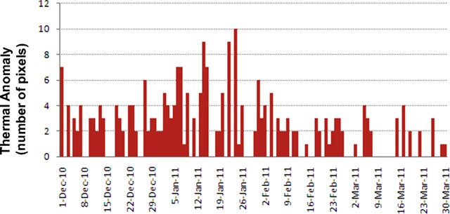 |
Figure 27. Satellite thermal anomalies recorded at Shiveluch during December 2010-March 2011. Data from KB GS RAS, with cooperation from Alaska Volcano Observatory (AVO). |
 |
Figure 28. A panoramic photo showing a long ash plume from Shiveluch, seen in the distant parts of the photo (volcano is on the left). Photo taken on 24 February 2011 from N slope of Kliuchevskoi volcano by Yuri Demyanchuk. |
More on the 27 October 2010PFs. As previously reported, an explosive eruption on 27 October 2010 (BGVN 35:11) vented at the dome and destroyed its SE portion, generating pyroclastic flows laden with many fragments of dome material (figure 29). The associated eruptive plume extended more than 1,500 km from the volcano. The pyroclastic flows traveled SSE in a radial direction, as far as 20 km from the source.
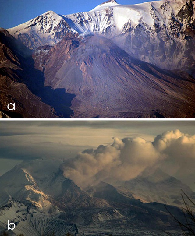 |
Figure 29. Two images showing the lava dome of Shiveluch. Photo (a) was taken before the eruption, on 7 October 2010. Photo (b) was taken a few days after the eruption, on 2 November 2010 and discloses enormous losses to the mass of the dome toward the SE (free face). The large ash clouds from the dome document ongoing explosions, processes associated with continued rebuilding of the lava dome. Both photos courtesy of Yuri Demyanchuk. |
Near the dome, visiting scientists found agglomerate deposits of fragmental dome material spread widely down the SE slope. The character of the deposits was similar to debris avalanches, since so much dome material suddenly traveled down slope. The pyroclastic flow deposits retraced numerous upslope tributaries along the Kabeku River. The deposits filled small valleys and other low-lying areas, leveling landscapes that had prior to the eruption been rough (figure 30).
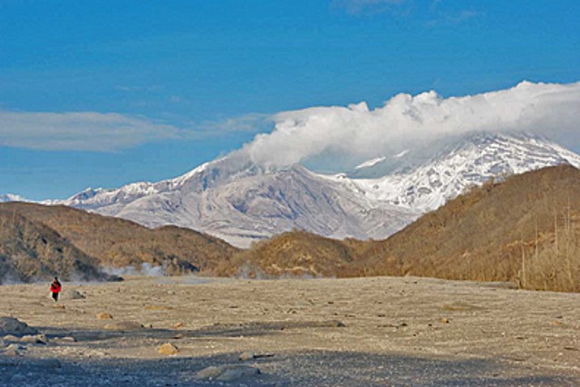 |
Figure 30. Photo showing the fresh pyroclastic flow deposits filling Bekesh river valley to the point where the valley had become nearly flat in transverse profile. In the background appears the steaming, Shiveluch with its recently broken lava dome. Photo taken 2 November 2010 by Alexander Ovsyannikov. |
Figures 31a and b, satellite images, illustrate the trail of hot material descending to the S. They formed a large, complex, and widely distributed deposit following the recent collapse of the lava dome. A sub-circular area about ~4 km in diameter at about 9-14 km distance from the dome may reflect denser deposition (figure 31a). The images make clear that pyroclastic flow deposits descended yet farther, leaving dense, thermally radiant tracks over narrower valleys trending to the SE. The images are from ASTER (Advanced Spaceborne Thermal Emission and Reflection Radiometer). Figure 31b shows the flow's heat signature as measured in thermal infrared energy. The white area at the lava dome was very hot, while the red areas on the edge of the flow were merely warmer than the surrounding snow.
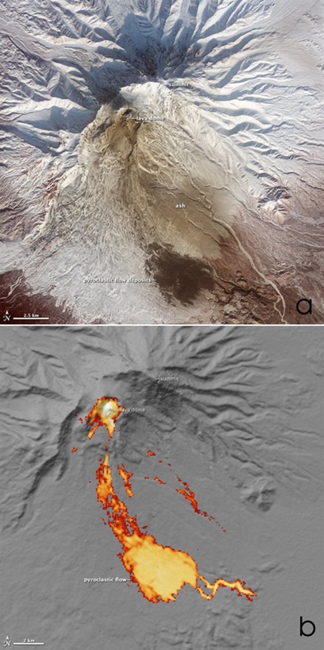 |
Figure 31. (a) False-color ASTER satellite image of Shiveluch showing the visible-wavelength information that discloses the remnants of the 27 October 2010 pyroclastic flow. Image taken 25 February 2011. (b) The hot pyroclastic flow appears in this ASTER image made using thermal infrared wave lengths. The white area at the lava dome is very hot, while the red areas on the edge of the flow are simply warmer than the surrounding snow. Image taken on 25 January 2011. Courtesy of NASA Earth Observatory. |
Fieldwork in the distal area revealed that the most powerful pyroclastic flow went into the headwaters of two narrow valleys, then merged into a single stream down into the Kabeku Valley river almost to its confluence with the Bekesh river (5 km N of the Kluchi-Ust'-Kamchatsk road, figures 32 and 33).
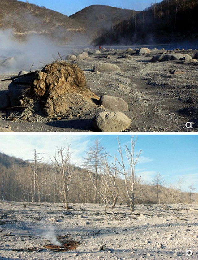 |
Figure 32. Images (a) and (b) show Shiveluch deposits of pyroclastic flows in the Bekesh river valley. Note person in distance in center of photo for scale. Courtesy Yuri Demyanchuk and Alexander Manevich. |
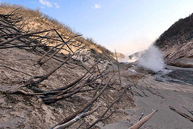 |
Figure 33. Results of pyroclastic surges, with small trees and shrubs knocked over and stripped of bark. Trees and shrubs showed signs of scorching up to 3-4 m high. Deposits of pyroclastic surges were found on the sides of the Bekesh river valley. Image taken 2 November 2010. Courtesy of Yuri Demyanchuk. |
Water in the bed of the Bekesh river ran down the same path as thick pyroclastic flows and continued to be fed by melting snow on the upper slopes. Water also seeped through the loose pyroclastic flow deposit, resulting in large amounts of steam escaping at the surface in the form of fumaroles, degassing pipes, and zones of jetting emissions. This created the impression that the river water was boiling; on its surface rose a wall of steam (figure 34). Walking over the pyroclastic flow deposit was difficult and potentially dangerous, since the deposit's upper portion remained hot and gas saturated (figure 34b).
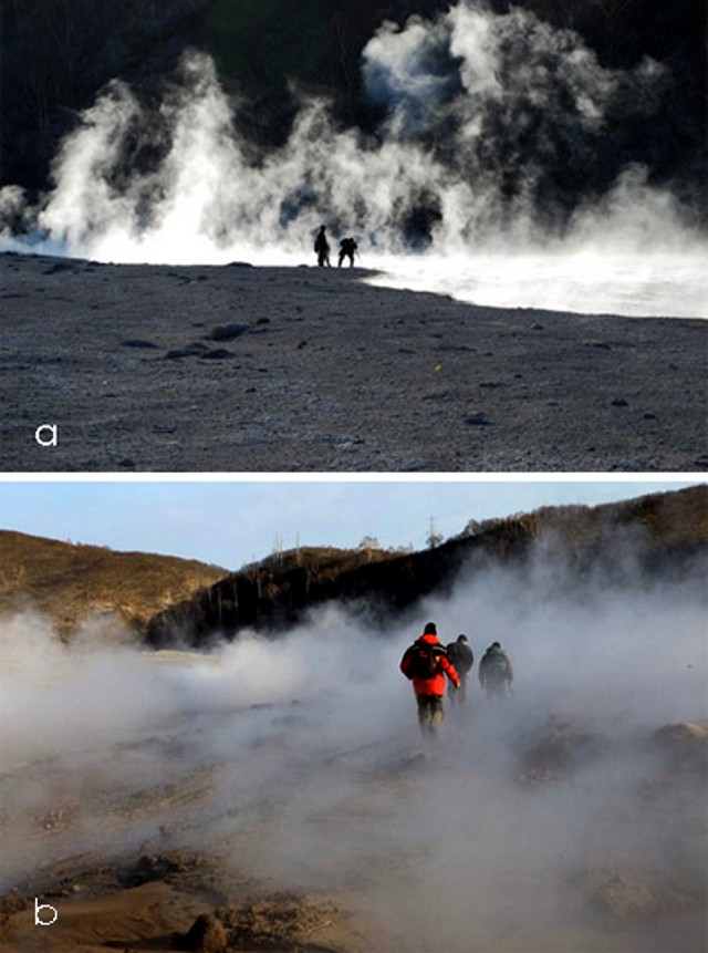 |
Figure 34. At Shiveluch, fresh pyroclastic-flow deposits occurring on the Bekesh river. (a) Steam and gas pervade the atmosphere as the river makes its way across the fresh pyroclastic-flow deposits. (b) The still-hot deposits emitting abundant steam and gas. Photos courtesy of Yuri Demyanchuk. |
Reference. Ovsyannikov, A., Manevich, A., 2010, Eruption Shiveluch in October 2010, Bulletin of Kamchatka Regional Association (Educational-Scientific Center); Earth Sciences (in Russian), IV&S FEB RAS, Petropavlovsk-Kamchatsky, 2010, vol. 2, no. 16, ISSN 1816-5532 (Online).
Geological Summary. The high, isolated massif of Sheveluch volcano (also spelled Shiveluch) rises above the lowlands NNE of the Kliuchevskaya volcano group. The 1,300 km3 andesitic volcano is one of Kamchatka's largest and most active volcanic structures, with at least 60 large eruptions during the Holocene. The summit of roughly 65,000-year-old Stary Shiveluch is truncated by a broad 9-km-wide late-Pleistocene caldera breached to the south. Many lava domes occur on its outer flanks. The Molodoy Shiveluch lava dome complex was constructed during the Holocene within the large open caldera; Holocene lava dome extrusion also took place on the flanks of Stary Shiveluch. Widespread tephra layers from these eruptions have provided valuable time markers for dating volcanic events in Kamchatka. Frequent collapses of dome complexes, most recently in 1964, have produced debris avalanches whose deposits cover much of the floor of the breached caldera.
Information Contacts: Kamchatka Volcanic Eruptions Response Team (KVERT), Institute Volcanolohy and Seismology Far East Division, Russian Academy of Sciences (IVS FED RAS), Kamchatka Branch of the Geophysical Service, Russian Academy of Sciences (KB GS RAS) (URL: http://www.emsd.iks.ru/index-e.php). 9 Piip Blvd., Petropavlovsk-Kamchatsky, 683006, Russia (URL: http://www.kscnet.ru/ivs/); Y. Demyanchuk, A. Ovsyannikov, A. Manevich (IVS FED RAS); Alaska Volcano Observatory (AVO), a cooperative program of the U.S. Geological Survey, 4200 University Drive, Anchorage, AK 99508-4667, USA (URL: http://www.avo.alaska.edu/); Tokyo Volcanic Ash Advisory Centre (VAAC), Tokyo, Japan (URL: http://ds.data.jma.go.jp/svd/vaac/data/); NASA Earth Observatory (URL: http://earthobservatory.nasa.gov/).