Report on Tambora (Indonesia) — August 2011
Bulletin of the Global Volcanism Network, vol. 36, no. 8 (August 2011)
Managing Editor: Richard Wunderman.
Edited by Robert Dennen.
Tambora (Indonesia) Increased seismicity and minor steam venting in 2011
Please cite this report as:
Global Volcanism Program, 2011. Report on Tambora (Indonesia) (Dennen, R., and Wunderman, R., eds.). Bulletin of the Global Volcanism Network, 36:8. Smithsonian Institution. https://doi.org/10.5479/si.GVP.BGVN201108-264040
Tambora
Indonesia
8.25°S, 118°E; summit elev. 2850 m
All times are local (unless otherwise noted)
Beginning in April 2011, Tambora volcano, Indonesia (figure 1), experienced increased seismic activity and minor steam venting. As a result, the Center for Volcanology and Geological Hazard Mitigation (CVGHM) raised the Alert Level for Tambora. This report will summarize the increased activity from April 2011 through 8 September 2011, as reported by CVGHM.
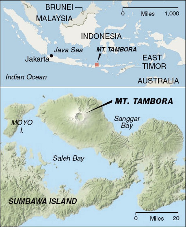 |
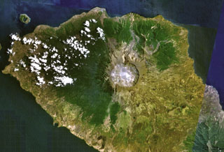
Figure 1. Regional (top) and local (bottom) geographic setting of Tambora volcano, Indonesia. Courtesy of Wilford (2006) and the New York Times. |
Seismicity at Tambora increased steadily from April 2011 to at least 8 September. CVGHM reported six seismic signals that were monitored: volcanic earthquakes (VA), shallow volcanic earthquakes (VB), distant tectonic earthquakes (TJ), local tectonic earthquakes (TL), low-frequency earthquakes (LF), and volcanic tremor. Seismic activity from April through August is summarized in figure 2. In addition to increased seismicity, ground-based observers described dense white plumes rising 50-75 m above the caldera rim in April and June.
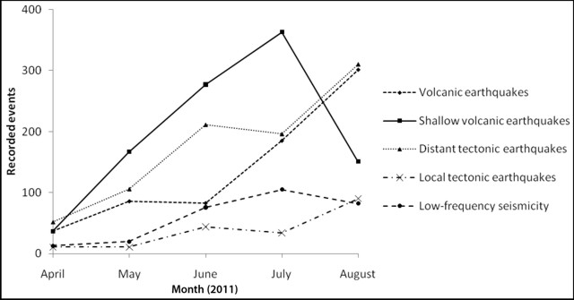 |
Figure 2. Reported seismic activity at Tambora cumulative by month from April through August 2011. Onset of continuous volcanic tremor on 29 August is not represented. Data from CVGHM. |
Volcanic tremor started 29 August and continued every day since, with the exception of 3 September (table 1). The tremor was accompanied by diffuse plumes rising 10-20 m above the caldera rim on 29 August and 5 September. Based on seismic activity and visual observations, CVGHM raised the Alert Level to 2 (on a scale from 1 to 4) on 30 August, and forbade access to the peak of Tambora.
Table 1. Summary of seismicity at Tambora since the onset of volcanic tremor on 29 August 2011. On both 29 August and 5 September seismicity was accompanied by plumes rising 10-20 m above the caldera rim. Data from CVGHM.
| Date | Volcanic A-type | Volcanic B-type | Local tectonic | Low-frequency | Tremor |
| 29 Aug 2011 | 14 | -- | 3 | -- | continuous |
| 30 Aug 2011 | 9 | 5 | 2 | 1 | continuous |
| 31 Aug 2011 | 6 | 5 | -- | 2 | continuous |
| 01 Sep 2011 | 15 | -- | 2 | 2 | continuous |
| 02 Sep 2011 | 6 | 4 | 4 | 6 | 11 |
| 03 Sep 2011 | 5 | 5 | 4 | 4 | -- |
| 04 Sep 2011 | 6 | 1 | 3 | 4 | 11 |
| 05 Sep 2011 | 11 | 7 | 3 | 1 | 4 |
| 06 Sep 2011 | 7 | 4 | -- | -- | continuous |
| 07 Sep 2011 | 40 | 6 | 1 | -- | continuous |
Along with the continuation of the tremor after 29 August, CVGHM reported an increase in other types of seismic activity from 30 August to 7 September. On 5 September an earthquake was felt by residents (exact location undisclosed). Instruments recorded 40 volcanic earthquakes on 7 September (table 1); 32 of those were recorded within 6 hours. On 8 September, CVGHM raised the Alert Level to 3, invoked a 3 km exclusion zone, and prohibited access to Disaster Prone Areas III, summarized in table 2. The Disaster Prone Areas were largely based on the devastating 1815 eruption of Tambora. As of 21 September, the Alert Level remained at 3.
Table 2. Summary of Disaster Prone Areas at Tambora defined on the basis of radial distance from the peak of Tambora. Courtesy of CVGHM.
| Area | Radius from Tambora | Potential hazards |
| Disaster Prone Area I | 8 km | Lahars, ash fall, and incandescent bombs. |
| Disaster Prone Area II | 5 km | Pyroclastic flows, lava flows, toxic gases, incandescent bombs, ash fall, lahars/mudflows, and high acidity in water. |
| Disaster Prone Area III | 3 km | Pyroclastic flows, lava flows, toxic gases, incandescent bombs, and heavy ash fall. |
References. Wilford, J.N., 2006, Under an 1815 Volcano Eruption, Remains of a 'Lost Kingdom', the New York Times, URL: http://www.nytimes.com/2006/02/28/science/28volc.html; Posted 28 February 2006; accessed 26 September 2011.
Geological Summary. The massive Tambora stratovolcano forms the entire 60-km-wide Sanggar Peninsula on northern Sumbawa Island. The largely trachybasaltic-to-trachyandesitic volcano grew to about 4,000 m elevation before forming a caldera more than 43,000 years ago. Late-Pleistocene lava flows largely filled the early caldera, after which activity changed to dominantly explosive eruptions during the early Holocene. Tambora was the source of history's largest explosive eruption, in April 1815. Pyroclastic flows reached the sea on all sides of the peninsula, and heavy tephra fall devastated croplands, causing an estimated 60,000 fatalities. The eruption of an estimated more than 150 km3 of tephra formed a 6-km-wide, 1250-m-deep caldera and produced global climatic effects. Minor lava domes and flows have been extruded on the caldera floor at Tambora during the 19th and 20th centuries.
Information Contacts: Center for Volcanology and Geological Hazard Mitigation (CVGHM), Jl. Diponegoro 57, Bandung, West Java, Indonesia, 40 122 (URL: http://www.vsi.esdm.go.id/).