Report on Soufriere Hills (United Kingdom) — August 2011

Bulletin of the Global Volcanism Network, vol. 36, no. 8 (August 2011)
Managing Editor: Richard Wunderman.
Edited by Robert Dennen.
Soufriere Hills (United Kingdom) Extrusive pause follows 11 February 2010 partial dome collapse
Please cite this report as:
Global Volcanism Program, 2011. Report on Soufriere Hills (United Kingdom) (Dennen, R., and Wunderman, R., eds.). Bulletin of the Global Volcanism Network, 36:8. Smithsonian Institution. https://doi.org/10.5479/si.GVP.BGVN201108-360050
Soufriere Hills
United Kingdom
16.72°N, 62.18°W; summit elev. 915 m
All times are local (unless otherwise noted)
Our previous report on Soufrière Hills volcano, Montserrat, (BGVN 35:03), was published in the month following the 11 February 2010 partial dome collapse, which consisted of 40-50 x 106 m3 of material (~20% of the dome's pre-collapse volume) and left a collapse scar ~ 300 m wide on the N flank of the dome. The ash column from this event reached ~15 km altitude, and large pyroclastic flows extended the island's E shoreline, creating ~1 km2 of new land surface. This event marked the end of Extrusive Phase 5, the most recent phase of extrusive activity since the volcano's awakening in 1995 (figure 88). Since then, and as recently as 9 September 2011, Soufrière Hills experienced a low level of activity with pyroclastic flows and rockfalls, but no significant extrusion of lava; a behavior typical of pauses in extrusion at this volcano since 1995 (figure 88). The Hazard Level remained at 3 (on a scale from 1 to 5). Most of the data and information in this report is from Cole and others, 2010 and Cole and others, 2011. Information has also been contributed by the Montserrat Volcano Observatory (MVO).
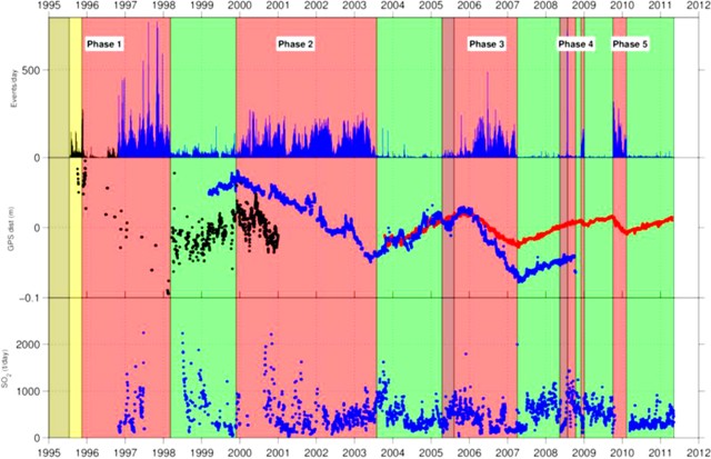 |
Figure 88. Extrusive phases (red areas) and pauses (green areas) of the Soufrière Hills eruption, Montserrat, from 1 January 1995 to 30 April 2011, based on seismic, GPS, and SO2 monitoring data. Top: number of seismic events detected. Middle: GPS data from three stations smoothed with a 7-day running mean filter. Bottom: Measured SO2 flux filtered with a 7-day running median filter. From Cole and others, 2011. |
Pyroclastic flows and rockfalls removed 3.65 x 10⁶ m3 (~ 1.9 % volume) of the dome from 12 February 2010 to 30 April 2011. Of these events, 54 were small pyroclastic flows (maximum runout of 1 km) and 31 were moderate-large pyroclastic flows (maximum runout of 2 km), generated mainly from three source regions:(1) above Gages Valley (W side); (2) N of the head of the 11 February 2010 collapse scar; and (3) at the head of the Tar River Valley (ESE side).
Undercutting of the dome face above Gages Valley (W side) by heavy summer rainfall in 2010 compromised dome stability and led to the largest pyroclastic flows. Pyroclastic flows occasionally generated small plumes and ashfall in inhabited areas of the island.
Lahars in the Belham Valley (on the volcano's W side) decreased from 40 measurable events (during late February-October 2010) to 10 measurable events (during November 2010-April 2011). The lahars were well correlated with peak rainfall events, and the 40 lahars occurring from 28 February to 31 October 2010 were attributed to especially heavy rainfall occurring in the months of April, late July, September, and October 2010. Figure 89 shows a house in Belham Valley partially covered by lahar deposits.
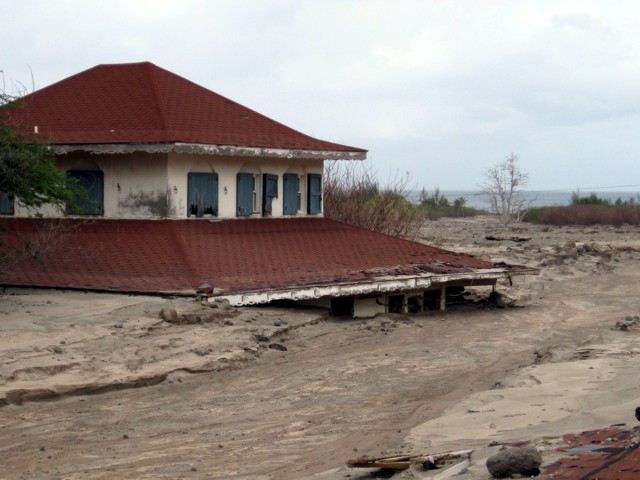 |
Figure 89. A house on the S side of the golf course that used to occupy the mouth of Belham Valley, Montserrat (Old Road Bay can be seen in the background). Photo by Robert Dennen (Global Volcanism Program) taken July 2010. |
As of 9 September 2011 the Washington Volcanic Ash Advisory Center (VAAC) reported eruptive plumes only a handful of times since 28 February 2010. Based on a METAR weather report and analyses of satellite imagery, on 10 August 2010 a narrow plume drifted 100 km WNW. According to the Washington VAAC, on 2 October 2010 the MVO reported that an ash plume rose to an altitude of 2.1 km altitude and drifted W. The next day an ash plume seen in satellite imagery drifted 55 km WNW and NW. A few hours later, an area of ash at an altitude of 2.1 km altitude was observed 140 km to the WNW. On 11 October a diffuse steam-and-gas plume drifted NNW.
Seismicity generally remained low, with low-frequency seismicity, long-period (LP), hybrid, and LP-rockfall events detected between 1 November 2010 and 9 September 2011 (figure 88). Short periods of volcano-tectonic (VT) earthquake activity on 25 June and 2 July 2010 were followed by ash venting; roaring could be heard N of the volcano. Another VT short swarm on 3 December 2010 was associated with an increase in gas emission and additional minor ash venting.
SO2 flux also remained low, with the daily average from 28 February 2010 to 30 April 2011 measured at 375 tons/day; low values typical of periods of pause. Elevated SO2 flux occurred in early May 2010 (up to 1,250 tons/day), November 2010, and March 2011 (figure 88).
During the reporting interval, mid-February 2010 to 9 September 2011, steady but weak inflation occurred, with only minor changes to the dome. The changes stemmed from mass wasting such as rockfalls and from pyroclastic flows.
Incandescence from various places on the lava dome was observed and analyzed (figure 90). The largest feature was a fumarolic gas vent on the floor of the 11 February collapse scar (see "Gas vent", figure 90 B, D). From the incandescent color, the temperature is estimated to be 500-600°C. Dome interior temperatures are considered likely nearly magmatic.
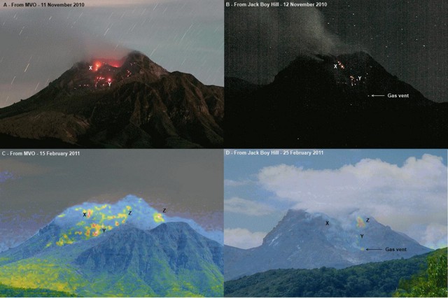 |
Figure 90. Four labeled images of Soufrière Hills calling attention to thermal features in the vent and dome area. The top two (A and B) represent night-time, long-exposure photographs. (A) An 11 November 2010 view from MVO (203 second exposure time). (B) A 12 November 2010 view from Jack Boy Hill (30 second exposure time). Features labeled X and Y are the most prominent incandescent/thermal features in the headwall of the 11 February 2010 collapse scar. (C and D) Photos with infrared enhancements indicated by colored zones (red representing hottest temperatures). (C) A 15 February 2011 view from MVO. (D) A 25 February 2011 view from Jack Boy Hill. Features labeled X and Y are as described above; those labeled Z were source areas for pyroclastic flows and rockfalls. From Cole and others, 2011. |
References. Cole, P., Bass, V., Christopher, T., Eligon, C., Murrell, C., Odbert, H., Smith, P., Stewart, R., Stinton, A., Syers, R., Robertson, R., and Williams, P., 2010, Report to the Scientific Advisory Committee on Volcanic Activity at Soufrière Hills Volcano Montserrat, Report on Activity between 28 February 2010 and 31 October 2010, Open File Report OFR 10-02a, Prepared for SAC 15: 15 ? 17 November 2010. Monsterrat Volcano Observatory (MVO).
Cole, P., Bass, V., Christopher, T., Murrell, C., Odbert, H., Smith, P., Stewart, R., Stinton, A., Syers, R., and Williams, P., 2011, MVO scientific report for volcanic activity between 1 November 2010 and 30 April 2011, Open File Report OFR 11-01. Monsterrat Volcano Observatory (MVO).
Geological Summary. The complex, dominantly andesitic Soufrière Hills volcano occupies the southern half of the island of Montserrat. The summit area consists primarily of a series of lava domes emplaced along an ESE-trending zone. The volcano is flanked by Pleistocene complexes to the north and south. English's Crater, a 1-km-wide crater breached widely to the east by edifice collapse, was formed about 2000 years ago as a result of the youngest of several collapse events producing submarine debris-avalanche deposits. Block-and-ash flow and surge deposits associated with dome growth predominate in flank deposits, including those from an eruption that likely preceded the 1632 CE settlement of the island, allowing cultivation on recently devegetated land to near the summit. Non-eruptive seismic swarms occurred at 30-year intervals in the 20th century, but no historical eruptions were recorded until 1995. Long-term small-to-moderate ash eruptions beginning in that year were later accompanied by lava-dome growth and pyroclastic flows that forced evacuation of the southern half of the island and ultimately destroyed the capital city of Plymouth, causing major social and economic disruption.
Information Contacts: Montserrat Volcano Observatory (MVO), Fleming, Montserrat, West Indies (URL: http://www.mvo.ms/); Washington Volcanic Ash Advisory Center (VAAC), Satellite Analysis Branch (SAB), NOAA/NESDIS E/SP23, NOAA Science Center Room 401, 5200 Auth Rd, Camp Springs, MD 20746, USA (URL: http://www.ospo.noaa.gov/Products/atmosphere/vaac/).