Report on Stromboli (Italy) — September 2011
Bulletin of the Global Volcanism Network, vol. 36, no. 9 (September 2011)
Managing Editor: Richard Wunderman.
Edited by Robert Dennen.
Stromboli (Italy) Recent activity; plumbing insights; new water vapor flux technique; hydrogeology
Please cite this report as:
Global Volcanism Program, 2011. Report on Stromboli (Italy) (Dennen, R., and Wunderman, R., eds.). Bulletin of the Global Volcanism Network, 36:9. Smithsonian Institution. https://doi.org/10.5479/si.GVP.BGVN201109-211040
Stromboli
Italy
38.789°N, 15.213°E; summit elev. 924 m
All times are local (unless otherwise noted)
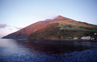
Activity at Stromboli (figure 76), since February 2010 (BGVN 35:03) through 11 October 2011 was generally of medium to low intensity, with minor fluctuations typical for Stromboli. Istituto Nazionale di Geofisica e Vulcanologia (INGV) reported occasional episodes of increased activity; note that the dates provided below are illustrative and by no means all-inclusive. This generally occurred as either more intense explosions or increased spattering (figure 77). More intense explosions often generated coarse pyroclastics and/or expelled erupted products farther than during typical activity, sometimes to the summit platform (Pizzo sopra la Fossa) overlooking the active craters, and beyond. For example, some specific pronounced events took place on 19 December 2010, 5 August, and 5 September 2011.
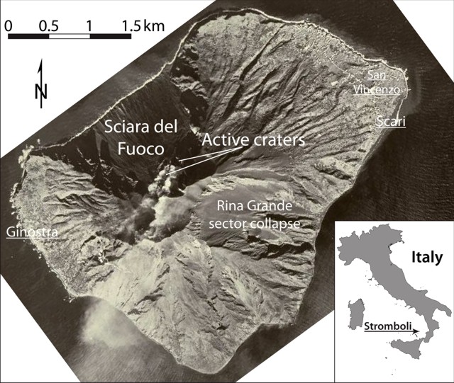 |
Figure 76. Index map (inset) and aerial photograph of Stromboli, showing the active vents and Sciara del Fuoco, a Pleistocene landslide scarp. Underlined names indicate coastal towns. Index map courtesy of Ginkgo Maps; aerial photograph courtesy of the Italian Air Force. |
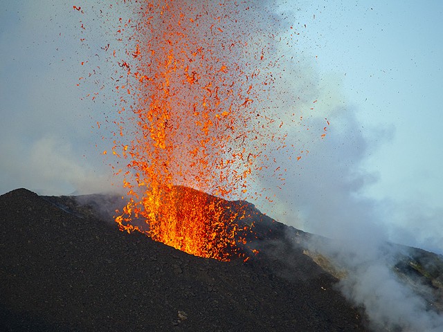 |
Figure 77. Photograph of an eruption at Stromboli at approximately 1930 on 15 July 2011 showing spattering behavior. Courtesy of Tom Pfeiffer, Volcano Discovery. |
On 30 June 2010, incandescent material thrown from the vent caused small fires on the upper flanks of the volcano. Increased spattering activity often resulted in intra- and, less frequently, extra-crater lava flows (figure 78a and b, respectively) such as those seen during 18-23 October 2010, 1-2 August, and 7 September 2011. The extra-crater lava flows of 1-2 August from the northernmost vent were the first observed since December 2010; they extended only a few hundred meters downslope (figure 78a). Extra-crater lava flows were often accompanied by land- or rock-slides down Sciara del Fuoco, fed by material that broke free from lava flow fronts and rolled down slope (e.g. 1 August 2011).
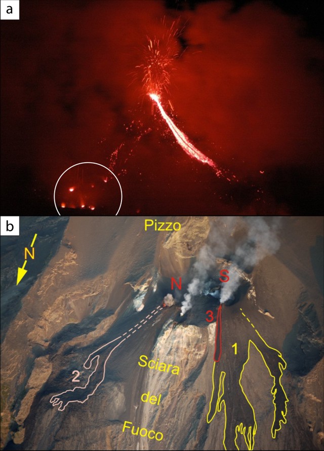 |
Figure 78. Intra-crater (a) and extra-crater (b) lava flows at Stromboli. (a) Spatter fed lava flow emitted from a small cone on the SW rim of the crater terrace; a small group of glowing vents can be seen at bottom left (circled). Photographed during the night of 11-12 August 2011 by Gijs de Reijke. (b) Aerial view of the summit area of Stromboli, highlighting extra-crater lava flows onto Sciara del Fuoco. The northern (N) and southern (S) vent areas are labeled in red; lava flows were emitted during 11-12 December 2010 (1, yellow), 1-2 August 2011 (2, pink), and on 18 August 2011 (3, red). Photo by Mauro Coltelli; courtesy of Istituto Nazionale di Geofisica e Vulcanologia (INGV). |
Some of the parameters reported by INGV during February 2010 to October 2011 included seismic, deformation, visual observation, and gas flux. The flux of CO2 and SO2, and particularly the CO2/SO2 ratio measured in the plumes, provided insight into the provenance of the generally discreet gas discharges ("gas slugs") that regularly burst upon reaching Stromboli's vent. INGV reported that a coupled increase in the CO2/SO2 ratio and decrease of SO2 flux (seen, for example, during the weeks of 5-12 and 19-26 September 2011) indicated an increased contribution of volatiles from deeper portions of the magmatic system.
Recent insight into magma generation. A study of erupted ash textures and compositions by D'Oriano and others (2011) yielded results comparable with the implications of the CO2/SO2 ratio reported by INGV. The authors use the commonly accepted terms for two separate populations of magma at Stromboli; these terms are presented and used herein.
"LP magmas" are those with low porphyricity (similar sized phenocrysts) that are considered to have relatively deeper origins and simple cooling histories. "HP magmas" are those with high porphyricity (multiple size populations of phenocrysts) that are considered to reside in a shallow reservoir in the crust and have more complex, multiple stage cooling histories.
D'Oriano and others (2011) found that there is a coupled, possibly persistent ascent of deep-derived CO2 and small amounts of LP magma. They concluded that the coupled ascent of LP magma and CO2 is transient and does not disturb the HP magma that resides in the shallow reservoir. See figure 79 for a schematic of the plumbing and magma storage zones of Stromboli.
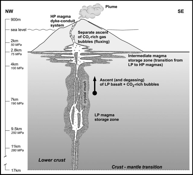 |
Figure 79. Schematic cross-section of Stromboli showing the crustal plumbing system and highlighting HP and LP magma storage zones. From Aiuppa and others (2010), based upon earlier works. |
New technique for measuring plume water vapor concentration. LIDAR (Light Detection and Ranging) has been used for the first time to measure water vapor flux of a volcanic plume. Fiorani and others (2011) used a CO2 laser-based LIDAR system called ATLAS (Agile Tuned Lidar for Atmospheric Sensing) at Stromboli to measure both wind speed and water vapor concentration of the erupted plume. When combined, the measurements yielded water vapor flux of the plume. Their measurements agreed with measurements obtained from traditional methods, and were the first such measurements at an active volcano.
Hydrogeology of Stromboli. A detailed geophysical survey of Stromboli revealed some hydrogeological features of the volcano (figure 80). Revil and others (2011) conducted a survey measuring electrical resistivity, soil CO2 concentrations, soil temperature, and self-potential along two profiles (a and b, figures 80 and 81). Their survey focused on the Pizzo crater (near the active vents), and the Rina Grande sector collapse on the E side of the island. They published a detailed schematic interpretation of fluid-flow pathways along the two profiles (figure 81).
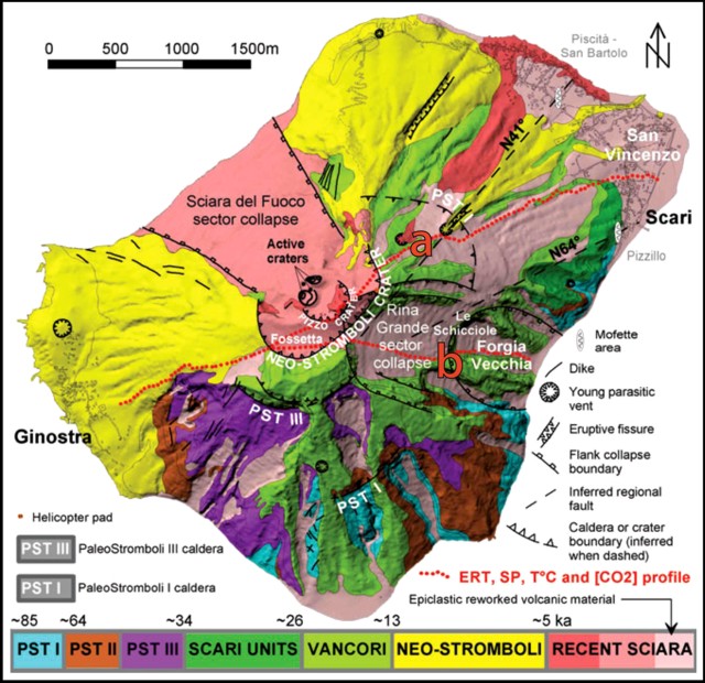 |
Figure 80. Geologic map of Stromboli. Red dots denote geophysical profiles of Revil and others (2011); (a) profile across Pizzo crater, near the active vents, and (b) profile down the length of the Rino Grande sector collapse, on the E flank of Stromboli. The two profiles are coincident to the W of Neo-Stromboli crater. Modified from Revil and others (2011). |
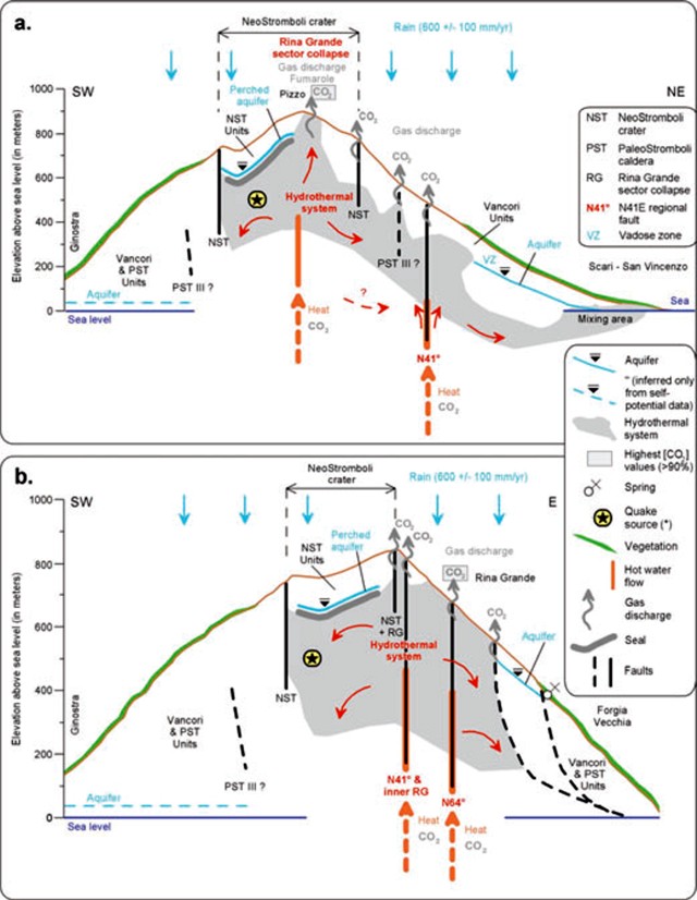 |
Figure 81. Interpretive hydrogeology diagram of Revil and others (2011) at Stromboli highlighting fluid flow pathways along two profiles; (a) profile across Pizzo crater, and (b) profile down the length of the Rino Grande sector collapse. See legend at right; areas in gray indicate the inferred extent of the hydrothermal system; orange lines and arrows indicate hot water flow; gray arrows indicate gas discharge; black solid and dashed lines indicate faults. See Revil and others (2011) for further details. |
The authors identified an unconfined aquifer above the villages of Scari and San Vincenzo. They stated that the Rina Grande sector collapse is the "most important structural control for magmatic and hydrothermal fluids" in the upper part of the Stromboli edifice, and that it hosts the two main diffuse degassing areas of the edifice. They further concluded that the hydrothermal system reaches shallow levels in the lower part of the Rina Grande collapse (profile b, figures 80 and 81). This fact, they wrote, "raises questions about the mechanical stability of this [E] flank of the edifice".
References. Aiuppa, A., Bertagnini, A., Métrich, N., Moretti, R., Di Muro, A., Liuzzo, M., Tamburello, G., 2010, A model of degassing for Stromboli volcano, Earth and Planetary Science Letters, v. 295, no. 1-2, p. 195-204 (DOI: 10.1016/j.epsl.2010.03.040).
D'Oriano, C., Bertagnini, A., and Pompilio, M., 2011, Ash erupted during normal activity at Stromboli (Aeolian Islands, Italy) raises questions on how the feeding system works, Bulletin of Volcanology, v. 73, no. 5, p. 471-477 (DOI:10.1007/s00445-010-0425-0).
Fiorani, L., Colao, F., Palucci, A., Poreh, D., Aiuppa, A., and Giudice, G., 2011, First-time lidar measurement of water vapor flux in a volcanic plume, Optics Communications, v. 284, no. 5, p. 1295-1298 (DOI:10.1016/j.optcom.2010.10.082).
Revil, A., Finizola, A., Ricci, T., Delcher, E., Peltier, A., Barde-Cabusson, S., Avard, G., Bailly, T., Bennati, L., Byrdina, S., Colonge, J., Di Gangi, F., Douillet, G., Lupi, M., Letort, J., and Tsang Hin Sun, E., 2011, Hydrogeology of Stromboli volcano, Aeolian Islands (Italy) from the interpretation of resistivity tomograms, self-potential, soil temperature and soil CO2 concentration measurements, Geophysical Journal International, v. 186, no. 3, p. 1078-1094 (DOI:10.1111/j.1365-246X.2011.05112.x).
Geological Summary. Spectacular incandescent nighttime explosions at Stromboli have long attracted visitors to the "Lighthouse of the Mediterranean" in the NE Aeolian Islands. This volcano has lent its name to the frequent mild explosive activity that has characterized its eruptions throughout much of historical time. The small island is the emergent summit of a volcano that grew in two main eruptive cycles, the last of which formed the western portion of the island. The Neostromboli eruptive period took place between about 13,000 and 5,000 years ago. The active summit vents are located at the head of the Sciara del Fuoco, a prominent scarp that formed about 5,000 years ago due to a series of slope failures which extends to below sea level. The modern volcano has been constructed within this scarp, which funnels pyroclastic ejecta and lava flows to the NW. Essentially continuous mild Strombolian explosions, sometimes accompanied by lava flows, have been recorded for more than a millennium.
Information Contacts: Boris Behncke and Mauro Coltelli, Istituto Nazionale di Geofisica e Vulcanologia (INGV), Sezione di Catania, 95125 Catania (URL: http://www.ct.ingv.it/); Ginkgo Maps (URL: http://www.ginkgomaps.com/); Italian Air Force (URL: http://www.aeronautica.difesa.it/); Tom Pfeiffer, Volcano Discovery (URL: http://www.volcanodiscovery.com/); Gijs de Reijke, Arnhem High School, Nijmegen, Netherlands.