Report on Mayon (Philippines) — September 2011

Bulletin of the Global Volcanism Network, vol. 36, no. 9 (September 2011)
Managing Editor: Richard Wunderman.
Edited by Robert Dennen.
Mayon (Philippines) Brief seismic crisis in May 2011, low activity follows
Please cite this report as:
Global Volcanism Program, 2011. Report on Mayon (Philippines) (Dennen, R., and Wunderman, R., eds.). Bulletin of the Global Volcanism Network, 36:9. Smithsonian Institution. https://doi.org/10.5479/si.GVP.BGVN201109-273030
Mayon
Philippines
13.257°N, 123.685°E; summit elev. 2462 m
All times are local (unless otherwise noted)
Mayon volcano (figure 19) underwent an eruptive crisis in late 2009 into early 2010 and a seismic crisis in May 2011. This report provides some final remarks on the late 2009 to early 2010 eruptive crisis, and summarizes activity through 23 September 2011. Our previous report summarized the heightened activity in December 2009, which culminated in the evacuation of 47,000 people from their homes (BGVN 34:12). The eruption waned following the evacuation, and, accordingly, the Philippine Institute of Volcanology and Seismology (PHIVOLCS) lowered the Alert Level from a high of 4 to 3 (on a scale from 0 to 5) on 2 January 2010. At that point, ~2,000 evacuees were still unable to return to their homes. On 13 January, the Alert Level was lowered from 3 to 2, and, according to Sophia Dedace (GMANews), enabled the remaining evacuees to return to their homes. Dedace reported that Governor Joey Salceda estimated the damage to agriculture and infrastructure from Mayon's 2009-2010 eruption at 26.2 million Philippine pesos (~$600,000 USD).
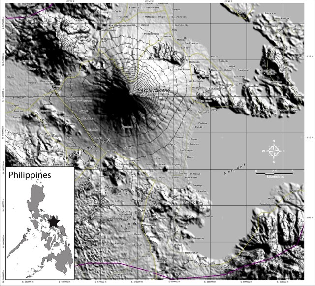 |
Figure 19. Maps showing geographic location (star on index map) and shaded relief map of Mayon volcano. Index map courtesy of Ginkgo Maps; shaded relief map courtesy of United Nations Institute for Training and Research's (UNITAR's) Operational Satellite Applications Programme (UNOSAT). |
On 2 March 2010, amid continually declining activity at Mayon, PHIVOLCS lowered the Alert Level from 2 to 1. As of 23 September 2011, the Alert Level remained unchanged, indicating, as stated by PHIVOLCS, "low level unrest" and that "no eruption [is] imminent." At Alert Level 1 (and all higher levels), access is prohibited within the 6-km-radius Permanent Danger Zone.
With the exception of May 2011, seismicity (figure 20) typically consisted of no more than a few volcanic earthquakes and rockfall events per day (i.e. less than 50 of either type per month) and relatively low SO2 flux (averaged per month on figure 20). Mayon typically vented ash-free steam at weak-to-moderate intensities, and crater glow persisted, observable by residents at night.
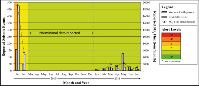 |
Figure 20. Reported volcanic earthquakes and seismically detected rockfall events per month (dark and light gray bars, respectively, left axis) and SO2 flux (open triangles and dashed line) averaged per month (right axis) at Mayon from 1 January 2010 to July 2011. Background colors indicate the Alert Level corresponding to the scale to the right of the figure. Little if any data are available from March through December 2010, presumably due to low activity during this interval. Data courtesy of Philippine Institute of Volcanology and Seismology (PHIVOLCS). |
During May 2011 there was a significant increase in seismicity, reaching a daily maximum of 38 volcanic earthquakes on 25 May. This increase coincided with a slight increase in the SO2 flux (averaged per month, figure 20). The increase in both seismicity and SO2 flux was short-lived, and activity declined to relatively low levels by June 2011.
Geological Summary. Symmetrical Mayon, which rises above the Albay Gulf NW of Legazpi City, is the most active volcano of the Philippines. The steep upper slopes are capped by a small summit crater. Recorded eruptions since 1616 CE range from Strombolian to basaltic Plinian, with cyclical activity beginning with basaltic eruptions, followed by longer term andesitic lava flows. Eruptions occur predominately from the central conduit and have also produced lava flows that travel far down the flanks. Pyroclastic flows and mudflows have commonly swept down many of the approximately 40 ravines that radiate from the summit and have often damaged populated lowland areas. A violent eruption in 1814 killed more than 1,200 people and devastated several towns.
Information Contacts: Philippine Institute of Volcanology and Seismology (PHIVOLCS), Department of Science and Technology, University of the Philippines Campus, Diliman, Quezon City, Philippines (URL: http://www.phivolcs.dost.gov.ph/); GMANews.TV, 6/F GMA Network Center, EDSA corner Timog Avenue, Diliman, Quezon City, 1101, PHILIPPINES (URL: http://www.gmanews.tv/index.html); United Nations Institute for Training and Research's (UNITAR's) Operational Satellite Applications Programme (UNOSAT), Palais des Nations, CH-1211 Geneva 10, Switzerland (URL: http://www.unitar.org/unosat/); Ginkgo Maps (URL: http://www.ginkgomaps.com/).