Report on Ijen (Indonesia) — December 2011

Bulletin of the Global Volcanism Network, vol. 36, no. 12 (December 2011)
Managing Editor: Richard Wunderman.
Edited by Robert Dennen.
Ijen (Indonesia) Sharp increase in seismicity in December 2011 spurs evacuation preparations
Please cite this report as:
Global Volcanism Program, 2011. Report on Ijen (Indonesia) (Dennen, R., and Wunderman, R., eds.). Bulletin of the Global Volcanism Network, 36:12. Smithsonian Institution. https://doi.org/10.5479/si.GVP.BGVN201112-263350
Ijen
Indonesia
8.058°S, 114.242°E; summit elev. 2769 m
All times are local (unless otherwise noted)
Ijen, which hosts both the world's largest highly acidic lake and intensive sulfur mining operations, showed increased seismicity and SO2 emissions during October-December 2011. The increased activity caused the Center for Volcanology and Geological Hazard Mitigation (CVGHM) to raise the Alert Level from 1-2 (on a scale from 1-4) on 15 December. The Alert Level was then raised from 2-3 on 18 December following further increases in activity.
1 October-15 December 2011 activity. CVGHM reported increased seismicity beginning in October 2011. Seismicity remained increased, yet more-or-less constant, through 15 December (figure 12a). Shallow volcanic earthquakes showed the greatest increase. The onset of harmonic tremor was reported during the first week of December, and increased tremor amplitude was reported beginning on 5 December.
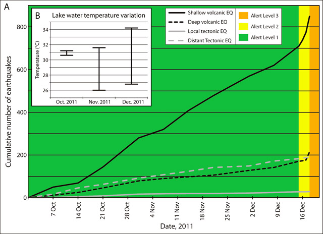 |
Figure 12. Reported seismicity (a) and crater lake temperatures (b) at Ijen during 1 October-17 December 2011. The Alert Level remained at 1 (green) until 15 December when it was raised to 2 (yellow); it was further increased to 3 (orange) on 18 December. Data courtesy of the Center for Volcanology and Geological Hazard Mitigation (CVGHM). |
Measured temperatures of the crater lake waters were mostly stable during October (ranging from 30.6-31.2°C), but showed significant variation and increased maximum temperatures during November and December 2011 (figure 12b). The measured pH of the crater lake waters also showed an increase during October-November, rising from 0.7±0.1 in October to 0.83±0.04 in November.
CVGHM also reported blasts of hot air and smoke that generated small plumes rising to 50-100 m above the peak in October, 50-150 m above the peak in November, and 50-200 m above the peak in December, outlining an increasing trend in the energy of the blasts. Plumes in October and November were reported to be sparse to medium white, while those in December were reported to be white to brown, indicating possible ash content in plumes generated during December.
During 1 October-15 December 2011, the color of the crater lake water remained whitish light green, and bubbling water was observed in the center of the lake. The area of bubbling water measured approximately 5 m in diameter. Clumps of sulphur were reported to coalesce in the center and on the shores of the crater lake. Vegetation in areas around the crater remained healthy.
On 15 December, CVGHM raised the Alert Level to 2, citing increased shallow and deep volcanic seismicity, the onset and increased amplitude of harmonic tremor 10 days prior, and visual observations as cause for concern. The CVGHM report expressed concern about possible phreatic, mud, or ash eruptions, and prohibited access to within 1 km of the crater lake.
Increased SO2 emissions. During the next few days, a sharp increase in shallow and deep volcanic seismicity (figure 12a) was accompanied by increased SO2 emissions. Observation on 17 December revealed the strong smell of sulphurous gases in the vicinity of the crater; so strong, in fact, that the CVGHM reported that measurements of lake water temperatures had become difficult without wearing a mask. The lake waters had changed color from whitish light green to completely white. All observations indicated an increased concentration of SO2 in the crater lake.
On 18 December, CVGHM raised the Alert Level to 3, and prohibited access to within 1.5 km of the crater lake. The Jakarta Post reported that the National Disaster Mitigation Agency (Badan Nasional Penanggulangan Bencana, BNPB) had prepared 466 million Indonesian Rupiah (US$51,260) in disaster-relief funds for the basic needs of evacuees for a two week period in the case that an evacuation occurred.
Geological Summary. The Ijen volcano complex at the eastern end of Java consists of a group of small stratovolcanoes constructed within the 20-km-wide Ijen (Kendeng) caldera. The north caldera wall forms a prominent arcuate ridge, but elsewhere the rim was buried by post-caldera volcanoes, including Gunung Merapi, which forms the high point of the complex. Immediately west of the Gunung Merapi stratovolcano is the historically active Kawah Ijen crater, which contains a nearly 1-km-wide, turquoise-colored, acid lake. Kawah Ijen is the site of a labor-intensive mining operation in which baskets of sulfur are hand-carried from the crater floor. Many other post-caldera cones and craters are located within the caldera or along its rim. The largest concentration of cones forms an E-W zone across the southern side of the caldera. Coffee plantations cover much of the caldera floor; nearby waterfalls and hot springs are tourist destinations.
Information Contacts: Center for Volcanology and Geological Hazard Mitigation (CVGHM), Jl. Diponegoro 57, Bandung, West Java, Indonesia, 40 122 (URL: http://www.vsi.esdm.go.id/); The Jakarta Post, Jl. Palmerah Barat 142-143, Jakarta 10270 (URL: http://www.thejakartapost.com/).