Report on Popocatepetl (Mexico) — September 2012

Bulletin of the Global Volcanism Network, vol. 37, no. 9 (September 2012)
Managing Editor: Richard Wunderman.
Edited by Julie A. Herrick.
Popocatepetl (Mexico) Intermittent ash plumes and diminished seismicity during July-October 2012
Please cite this report as:
Global Volcanism Program, 2012. Report on Popocatepetl (Mexico) (Herrick, J.A., and Wunderman, R., eds.). Bulletin of the Global Volcanism Network, 37:9. Smithsonian Institution. https://doi.org/10.5479/si.GVP.BGVN201209-341090
Popocatepetl
Mexico
19.023°N, 98.622°W; summit elev. 5393 m
All times are local (unless otherwise noted)
Since our last report discussing ash plumes and increased seismicity noted in April 2012 (BGVN 37:05), ash plumes from Popocatépetl's summit continued to be emitted at a reduced rate during July-October 2012. During this reporting period, the Centro Nacional de Prevención de Desastres (CENAPRED, based in Mexico City) noted persistent incandescence and gas emissions (sometimes containing ash). Seismicity decreased significantly in August and, on 1 September, CENAPRED reduced the Alert Level from Yellow, Phase Three to Yellow, Phase Two. New volcanic hazard maps were available from investigators focused on ejecta from the summit (Alatorre-Ibargüengoitia and others, 2012) and CENAPRED developed an interactive web interface for compiling layers of hazard zones based on volcanic phenomena expected from Popocatépetl.
Visual observations July-October 2012. From July through October 2012, CENAPRED reported that cloudcover frequently obscured the view of Popocatépetl's summit. During cloud-free conditions, incandescence from the crater could be observed at night and early in the morning. Moderate explosions (many containing incandescent tephra) occurred almost daily.
Several larger explosions were observed by CENAPRED on 21 July, in August (7, 17, 18, 20, 26 and 27), September (10, 14, and 15), and October (17, 18, 20, and 26). These events were captured by web cameras when incandescent tephra was ejected and traveled up to 1.5 km from the summit (figure 64).
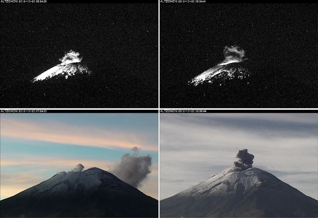 |
Figure 64. On 20 October 2012, the webcamera Altzomoni (located ~10 km to the NNW) captured moderate-sized explosions from Popocatépetl that ejected incandescent tephra across high elevation areas (within 1 km of the summit). From left to right, photos were captured at 05:34:25, 05:34:41, 07:24:23, and 09:36:44. Courtesy of CENAPRED. |
When conditions permitted during July-October, gas-and-steam plumes (frequently containing ash), were observed reaching 0.5 to 2.5 km above the crater. Asfall was reported in the community of Ozumba (18 km W) on 21 July 2012. CENAPRED reported that an ash plume rose 4 km above the crater at 1758 on 6 August; incandescence from the crater was also observed that day.
Two lahars were detected in July 2012. The event on 3 July occurred at 1530 and was documented by the Tlamacas web camera (located ~5 km N of the crater). On 12 July, between 1938 and 2135, a lahar occurred on the N flank. Both of these events were attributed to glacial melt high on the flanks of Popocatépetl; no flooding was reported at low elevations.
VAAC ash detection during July-October 2012. The Washington Volcanic Ash Advisory Center (VAAC) announced observations of intermittent ash plumes from Popocatépetl during July-August 2012. At least five announcements were based on CENAPRED reports and imagery from local web cameras; cloud cover frequently obscured remote sensing images. During July-August, plume altitudes were in the range of 6.4-9.1 km (0.97-3.67 km above the crater); plumes tended to drift up to 130 km to the W, S, and SE.
No VAAC reports were released in September 2012 and five reports of observed ash were made in October 2012. During 11-26 October, maximum altitudes of ash plumes reached 7.6 km (~2.2 km above the crater) and tended to drift W, NW, and S.
Seismicity during July-October 2012. Decreasing seismicity was detected at Popocatépetl between July and October 2012. Approximately 30 hours of tremor were recorded by CENAPRED in July and ~18 hours in August, while approximately 9 and 10 hours were recorded in September and October, respectively. Volcano-tectonic (VT) earthquakes also occurred less frequently between July (~53 detected) and September (four detected). In October, ~15 VT events were reported in CENAPRED's online reports.
Hazard map for volcanic ejecta. A recent investigation by Alatorre-Ibargüengoitia and others (2012) highlighted the frequently-occurring Vulcanian eruptions of Popocatépetl and developed a volcanic ejecta risk assessment. Volcanic bombs have impacted the immediate summit area of the volcano as well as locations as distant as 3.7 km (the maximum distance considered in the simulations). The investigators combined video observations of past eruptions, field studies (between 1999 and 2010), and a ballistics model designed for simulating optimal launching conditions. One of the results from this investigation was a map defining three risk zones (figure 65).
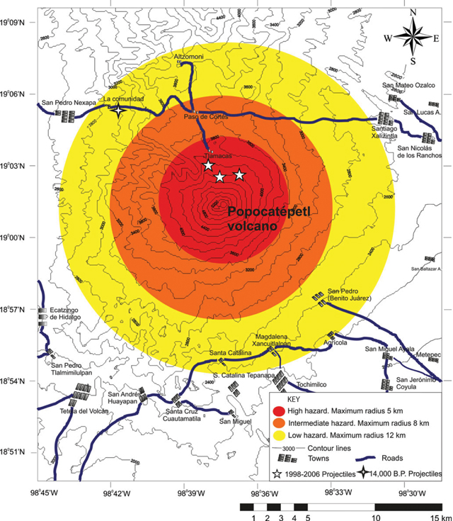 |
Figure 65. This map of Popocatépetl's summit, flanks, and local infrastructure includes hazard zonation for volcanic bombs. Locations with 5-point stars represent observed impact sites from 1998-2006; the 4-point star represents an impact site dating to 14,000 years before present. From Alatorre-Ibargüengoitia and others (2012). |
An interactive hazard map for Popocatépetl was available online through the CENAPRED website (figure 66). Basemap options included terrain, streets with major towns, and satellite imagery. Users were able to choose from various volcanic phenomena (lava flows, ash fall, lahars, and pyroclastic flows) to view the predicted aerial extent of the relevant hazard. The flow paths and inundation areas for lava flows, lahars, and pyroclastic flows were determined with TITAN2D software based on data collected by CENAPRED. The zones representing high (red), medium (orange), and low (yellow) risk of ashfall (note the concentric zones in figure 66) were developed based on a 1995 study by CENAPRED (Macias and others, 1995).
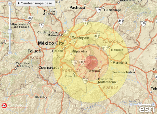 |
Figure 66. This map is a screenshot of CENAPRED's interactive hazard map, showing results from four scenarios; three types of lahar inundation parameters (highlighted drainages within ~40 km of the summit) and zones defining potential ashfall. Note that lahar hazards are within the orange zone of moderate ashfall hazards; the yellow zone indicating minor ashfall reaches Mexico City. The radius of the yellow zone (minor ashfall) is ~70 km. Courtesy of CENAPRED. |
References. Alatorre-Ibargüengoitia, M.A., Delgado-Granados, H., and Dingwell, D.B., 2012. Hazard map for volcanic ballistic impacts at Popocatépetl volcano (Mexico), Bulletin of Volcanology, 74(9) pp 2,155-2,169.
Macias, J.L., Carrasco, G., Delgado, H., Martin del Pozzo, A.L., Siebe, C., Hoblitt, R., Sheridan, M.F., and Tilling, R.I., 1995. Mapa de peligros volcanicos del Popocatépetl, Pub especial Inst Geofis, UNAM.
Geological Summary. Volcán Popocatépetl, whose name is the Aztec word for smoking mountain, rises 70 km SE of Mexico City to form North America's 2nd-highest volcano. The glacier-clad stratovolcano contains a steep-walled, 400 x 600 m wide crater. The generally symmetrical volcano is modified by the sharp-peaked Ventorrillo on the NW, a remnant of an earlier volcano. At least three previous major cones were destroyed by gravitational failure during the Pleistocene, producing massive debris-avalanche deposits covering broad areas to the south. The modern volcano was constructed south of the late-Pleistocene to Holocene El Fraile cone. Three major Plinian eruptions, the most recent of which took place about 800 CE, have occurred since the mid-Holocene, accompanied by pyroclastic flows and voluminous lahars that swept basins below the volcano. Frequent historical eruptions, first recorded in Aztec codices, have occurred since Pre-Columbian time.
Information Contacts: Centro Nacional de Prevención de Desastres (CENAPRED), Av. Delfín Madrigal No.665. Coyoacan, México D.F. 04360, México (URL: https://www.gob.mx/cenapred/); Washington Volcanic Ash Advisory Center (VAAC), Satellite Analysis Branch (SAB), NOAA/NESDIS E/SP23, NOAA Science Center Room 401, 5200 Auth Rd, Camp Springs, MD 20746, USA (URL: http://www.ospo.noaa.gov/Products/atmosphere/vaac/).