Report on Ol Doinyo Lengai (Tanzania) — November 2012

Bulletin of the Global Volcanism Network, vol. 37, no. 11 (November 2012)
Managing Editor: Richard Wunderman.
Ol Doinyo Lengai (Tanzania) Update on observations and activity during 2011-2012
Please cite this report as:
Global Volcanism Program, 2012. Report on Ol Doinyo Lengai (Tanzania) (Wunderman, R., ed.). Bulletin of the Global Volcanism Network, 37:11. Smithsonian Institution. https://doi.org/10.5479/si.GVP.BGVN201211-222120
Ol Doinyo Lengai
Tanzania
2.764°S, 35.914°E; summit elev. 2962 m
All times are local (unless otherwise noted)
Ol Doinyo Lengai, located close to the N border of Tanzania (figure 153), is both accessible and monitored closely.
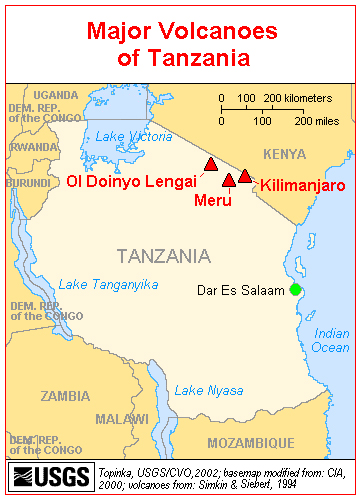 |
Figure 153. Map of Tanzania showing Ol Doinyo Lengai's proximity to Meru and Kilimanjaro. Courtesy of USGS/CVO. |
Frederick Belton's Ol Doinyo Lengai web site has provided many interesting photos from the expeditions that he has taken to the volcano since his initial visit in 1997, including annual visits until 2006, followed by his last expedition in 2008. In addition, Belton has included in his web site observations, photographs, and other graphics provided by many visitors to Ol Doinyo Lengai; these descripions have been the primary source of reports found in the Bulletin. Recently, Belton informed Bulletin editors that he rarely gets any updates on visits to Ol Doinyo Lengai for his web site, but he did receive one in September 2012. Bulletin editors wrote to a number of past contributors to BGVN; some of their comments are included below.
Belton's web site reported that Frank Möckel and Wendy Blank visited Ol Doinyo Lengai's summit area (figure 154) in September 2012. They climbed the volcano during 14-15 September and camped in the S Crater during the nights of 15 and 16 September (figure 155). Figures 155-160 contain some views they captured at the summit of the volcano. Figures 157 and 158 show what appear to be active spatter cones inside the N Crater. According to Belton, the activity looks very typical of the type frequently seen prior to the last explosive eruption in 2007-2008 (BGVN 32:11). Möckel and Blank reported that on the bottom of the active N Crater they saw fresh black natrocarbonatite lava and active vents, and they heard boiling noises from the bottom of the N Crater. They reported a strong smell of hydrogen sulfide (H2S) everywhere in the area.
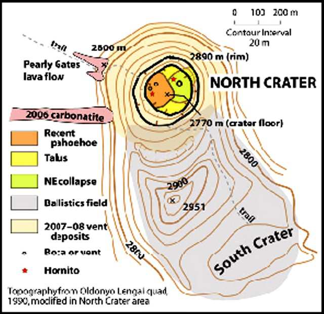 |
Figure 154. Topographic map modified from the Ol Doinyo Lengai quadrangle of 1990, with a contour interval of 20 m. The original map was modified in the N Crater area from observations made on 12 March 2010. Courtesy of Sherrod and others (2010). |
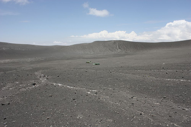 |
Figure 155. Ol Doinyo Lengai's S Crater, seen with tents for scale (center). Photo taken 14-15 September 2012. Courtesy of Frank Möckel and Wendy Blank. |
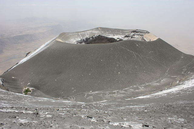 |
Figure 156. View of Ol Doinyo Lengai's N Crater as seen from the summit. Photo taken 14-15 September 2012. Courtesy of Frank Möckel and Wendy Blank. |
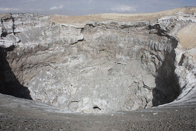 |
Figure 157. Ol Doinyo Lengai's active N Crater as seen from an unidentified point on the crater rim. Photo taken 14-15 September 2012. Courtesy of Frank Möckel and Wendy Blank. |
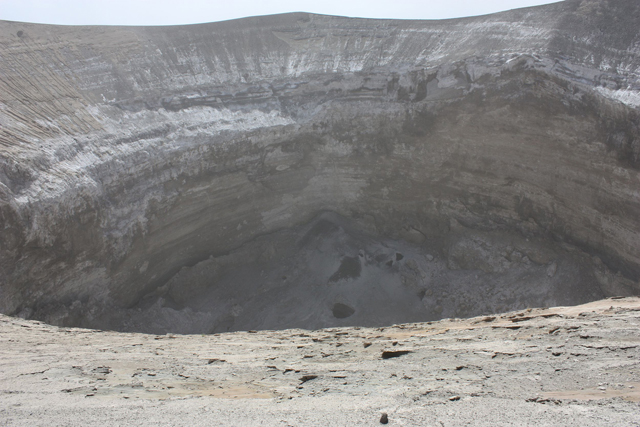 |
Figure 158. View looking down into Ol Doinyo Lengai's N Crater at interior spatter cones. Photo taken 14-15 September 2012. Courtesy of Frank Möckel and Wendy Blank. |
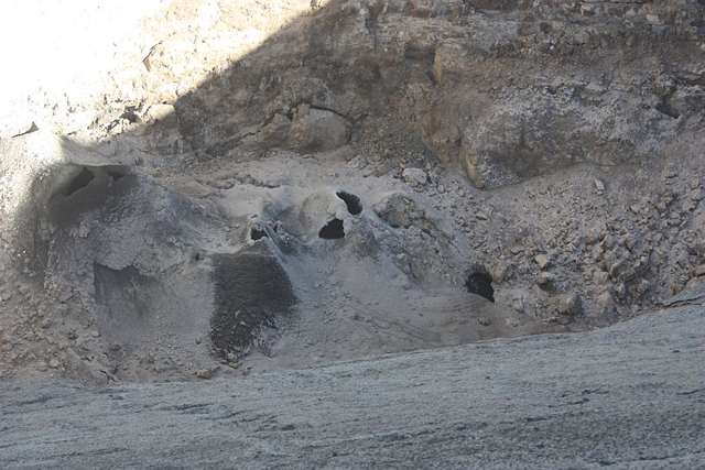 |
Figure 159. A closer view of Ol Doinyo Lengai's N Crater floor showing several vent openings (black) and an area of fresh spatter covering a region downhill of a vent. Photo taken 14-15 September 2012. Courtesy of Frank Möckel and Wendy Blank. |
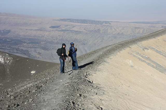 |
Figure 160. Climbers on the NE rim of Ol Doinyo Lengai's N crater. Photo taken 14-15 September 2012. Courtesy of Frank Möckel and Wendy Blank. |
Abigail Church, who studied Ol Doinyo Lengai for her PhD dissertation in 1996 and has published several articles on the petrogensis of the natrocarbonatite lavas, now lives in Nairobi, Kenya, and regularly flies over Ol Doinyo Lengai in chartered aircraft. She has flown over and landed on Ol Doinyo Lengai in a helicopter probably 5 times in the last few years. She camped close to the volcano in November 2012 and flew around the summit, however, it was cloudy. On many occasions when she was able to see into the crater, she observed what appeared to be small-scale activity continuing in the base of the deep pit. There are normally 1 or 2 active vents in which one can see very dark material which she assumed was fresh natrocarbonatite lava. She also has good contacts with people in the area and with pilots who fly the routes between Arusha and the Serengeti. On recent flights over Ol Doinyo Lengai, Church has observed that the sides of the central crater within the N Crater are collapsing inwardly, reducing the depth of the crater hole, and that small scale activity in the crater continues. Figures 161-165 show some photographs from 2011 and 2012 of the inside of Ol Doinyo Lengai's N crater.
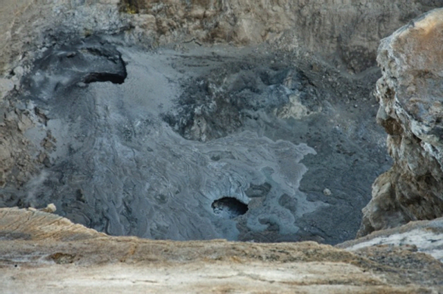 |
Figure 161. Ol Doinyo Lengai's N crater floor showing a vent and some spatter. Photo taken 2 December 2011. Courtesy of Phil Mathews and Abigail Church. |
 |
Figure 162. A collapse in the floor of Ol Doinyo Lengai's N crater, showing natrocarbonatite lava flows. Photo taken 2 December 2011. Courtesy of Phil Mathews and Abigail Church. |
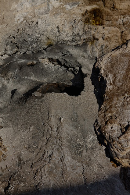 |
Figure 163. Small active vent in the N Crater floor of Ol Doinyo Lengai. Photo taken 2 December 2011. Courtesy of Phil Mathews and Abigail Church. |
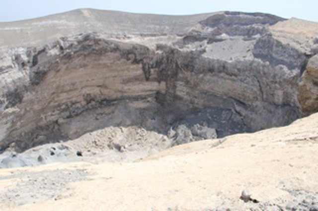 |
Figure 164. A view of Ol Doinyo Lengai's N Crater from over the rim. Photo taken in August 2012. Courtesy of Phil Mathews and Abigail Church. |
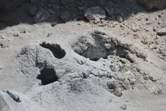 |
Figure 165. A recently active vent on Ol Doinyo Lengai's N Crater floor. Photo taken in August 2012. Courtesy of Phil Mathews and Abigail Church. |
Hannes Mattsson reported to Bulletin staff that he has 3 PhD projects running on different aspects of Ol Doinyo Lengai volcanism, but he has not been at the volcano for about 1.5 years. He is planning a 6-week field campaign scheduled in mid 2013. He noted that very little current or recent information on Ol Doinyo Lengai is currently available.
Joerg Keller also noted that there are not many recent reports about activity in the crater area. According to reports of Möckel's visit in February 2010 (BGVN 35:05), the access route to and from Ol Doinyo Lengai's summit seems much more difficult to negotiate than before the 2007 eruption. Keller believes that another possible factor leading to less observations of Ol Doinyo Lengai is the change in the crater formations since the eruption of 2007. There seems to be little change since 2008, a stable situation with the new ash cone dominating the entire N crater area completely (see figures in BGVN 32:11 and 33:02, as well as the above photos). The unique crater landscape seen before 2007, with accessible hornitos and lava flows of different ages, and the chance to see active spatter cones, lava pools and flowing lava, was an attraction to visiters. The logistical problems for visiting and climbing the volcano since 2008, incluing safety and political factors, have resulted in greatly diminished numbers of visitors.
Keller reported that Elias Danner, a teenage photographer, filmer, and designer, started Ol Doinyo Lengai photo documentation that shows the ash cone, its deep pit, and, in particular, looks inside the pit with fresh, overlapping lava lobes and vigorously boiling lava pools. Keller received from Danner a video of the boiling lava pools which was so typical and so impressive that he wrote in a recent paper (Keller and Zaitsev, 2012) the following: "The present vertically sided, almost 100 m deep pit crater formed by the 2007-2008 explosive activity is inaccessible. However, since 2008 frequent overflights and reports and photographs by visitors climbing the mountain (Belton, 2012) suggest that new natrocarbonatite effusions are occurring at the bottom of the deep pit. This is indicated from a distance by the typical morphological features of natrocarbonatite appearing as small hornitos and gray pahoehoe flows on the floor of the crater. On 26th June 2011, Elias Danner ... filmed a vigorously boiling and splashing, obviously carbonatitic lava pool at the bottom of the pit, with features very reminiscent of Figs. 5 and 6 in Keller and Krafft (1990)."
MODIS/MODVOLC Satellite Thermal Alerts. Table 26 gives an update of MODVOLC satellite thermal alerts at the Ol Doinyo Lengai summit since a similar update found in BGVN 33:06. It is not uncommon to find thermal alerts down and beyond the sides of the volcano, probably caused by fires. It is possible that fewer thermal alerts are measured by the MODIS satellites because the current deep crater (since the 2007-2008 eruptions) shields some of the hotter areas from the satellite sensors.
Table 26. MODVOLC thermal alerts measured at Ol Doinyo Lengai from 3 April 2008 to December 2012. Courtesy of the Hawai`i Institute of Geophysics and Planetology (HIGP) Thermal Alerts System.
| Date | Time (UTC) | Number of pixels | MODIS Satellite |
| 03 Apr 2008 | 2325 | 1 | Aqua |
| 13 Dec 2008 | 2005 | 1 | Terra |
| 13 Nov 2010 | 0810 | 1 (N side of crater) | Terra |
| 02 Oct 2011 | 1135 | 2 (N side of crater) | Aqua |
| 02 Oct 2011 | 1925 | 2 (N side of crater) | Terra |
| 22 Jun 2012 | 0750 | 4 (S side of crater) | Terra |
References. Belton, F., 2012, Oldoinyo Lengai, The Mountain of God (URL: www.oldoinyolengai.pbworks.com).
Keller, J., and Krafft, M., 1990, Effusive natrocarbonatite activity of Oldoinyo Lengai, June 1988, Bulletin of Volcanology v. 52, pp. 629-645.
Keller, J., and Zaitsev, A.N., 2012, Geochemistry and petrogenetic significance of natrocarbonatites at Oldoinyo Lengai, Tanzania: Composition of lavas from 1988 to 2007, Lithos, v.148, pp. 45-53.
Sherrod, D., Mollel, K., and Nantatwa, O., 2010, Oldoinyo Lengai: Trip Report, March 12-14, 2010, informal report (URL: http:/Sherrod_OldonyoLengai_March12_20106-1.pdf).
Geological Summary. The symmetrical Ol Doinyo Lengai is the only volcano known to have erupted carbonatite tephras and lavas in historical time. The prominent stratovolcano, known to the Maasai as "The Mountain of God," rises abruptly above the broad plain south of Lake Natron in the Gregory Rift Valley. The cone-building stage ended about 15,000 years ago and was followed by periodic ejection of natrocarbonatitic and nephelinite tephra during the Holocene. Historical eruptions have consisted of smaller tephra ejections and emission of numerous natrocarbonatitic lava flows on the floor of the summit crater and occasionally down the upper flanks. The depth and morphology of the northern crater have changed dramatically during the course of historical eruptions, ranging from steep crater walls about 200 m deep in the mid-20th century to shallow platforms mostly filling the crater. Long-term lava effusion in the summit crater beginning in 1983 had by the turn of the century mostly filled the northern crater; by late 1998 lava had begun overflowing the crater rim.
Information Contacts: Frederick Belton, University Studies Department, Middle Tennessee State University, Murfreesboro, TN (URL: http://oldoinyolengai.pbworks.com/); Sonja Bosshard, Institute of Geochemistry and Petrology, Swiss Federal Institute of Technology Zürich (ETH Zürich), Zürich, Switzerland; Laura Carmody, Planetary Geoscience Institute, Department of Earth and Planetary Sciences, University of Tennessee, Knoxville, TN; Abigail Church, The Ker & Downey Safari Tradition, P.O. Box 86, Karen 00502, Kenya; Elias Danner, Elias Danner Productions (URL: http://www.mammut-studios.com/); Joerg Keller, Institut für Geowissenschaften/Mineralogie-Geochemie, Universität Freiburg, Albertstrasse 23b, 79104 Freiburg, Germany; Hannes B. Mattsson, Institute of Geochemistry and Petrology, Swiss Federal Institute of Technology Zürich (ETH Zürich), Zürich, Switzerland; Frank Möckel; Celia Nyamweru, St. Lawrence University; David Sherrod, Cascades Volcano Observatory (CVO), U.S. Geological Survey, Vancouver, WA (URL: https://volcanoes.usgs.gov/observatories/cvo/); Christoph Weber, Volcano Expeditions International (VEI), Muehlweg 11, 74199 Untergruppenbach, Germany (URL: http://www.v-e-i.de/); Ben Wilhelmi, commercial pilot (URL: http://benwilhelmi.typepad.com/benwilhelmi/).