Report on Izu-Oshima (Japan) — January 2013
Bulletin of the Global Volcanism Network, vol. 38, no. 1 (January 2013)
Managing Editor: Richard Wunderman.
Izu-Oshima (Japan) Non-eruptive May 2010 surface deformation from inferred deep instrusion
Please cite this report as:
Global Volcanism Program, 2013. Report on Izu-Oshima (Japan) (Wunderman, R., ed.). Bulletin of the Global Volcanism Network, 38:1. Smithsonian Institution. https://doi.org/10.5479/si.GVP.BGVN201301-284010
Izu-Oshima
Japan
34.724°N, 139.394°E; summit elev. 746 m
All times are local (unless otherwise noted)
Oshima is an active volcano located on the northern tip of the Izu-Bonin volcanic arc. Our last report of activity at Oshima (BGVN 21:08) enumerated a flurry of shallow low-frequency earthquakes beneath the top and W flank of the volcano that started on 5 August 1996.
Since those relatively benign events, the Japan Meteorological Agency (JMA) had not observed any subsequent events worthy of note until May 2010 when land surface inflation was detected. The inflation was registered by a strainmeter, a Global Positioning System (GPS) network (run by the Geospatial Information Authority of Japan, GSI), and a tiltmeter network (run by the National Research Institute for Earth Science and Disaster Prevention, NIED).
In July 2010 seismicity in the shallow parts of and around Oshima began to increase. (High seismicity synchronous with inflation of the edifice was seen earlier, including in 2004 and 2007). These events were considered to be due to magma intrusion into the deeper part of the volcano. There were no remarkable changes in surface phenomenon. In September, the inflation that was detected in May began declining. Seismicity in the shallow parts of and around Oshima continued at a low level with some small earthquakes which temporally increased in the western offshore areas of Oshima on 22 December 2010.
The earthquakes increased in frequency again on 9 February 2011. GPS and strainmeter measurements indicated contraction since January, but the trend reversed to show inflation in October 2011. Seismicity remained at a low level. Very low level gas emissions were sometimes observed by a camera positioned on the NW summit. Based on a field survey on 28 October, no remarkable change in surface phenomena was observed.
No remarkable activity has been noted since October 2011. Throughout the noted activity, JMA held the Alert Level at 1.
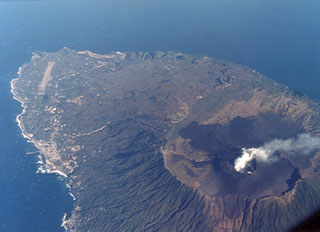
Geological Summary. Izu-Oshima volcano in Sagami Bay, east of the Izu Peninsula, is the northernmost of the Izu Islands. The broad, low stratovolcano forms an 11 x 13 km island constructed over the remnants of three older dissected stratovolcanoes. It is capped by a 4-km-wide caldera with a central cone, Miharayama, that has been the site of numerous recorded eruptions datining back to the 7th century CE. More than 40 cones are located within the caldera and along two parallel rift zones trending NNW-SSE. Although it is a dominantly basaltic volcano, strong explosive activity has occurred at intervals of 100-150 years throughout the past few thousand years. A major eruption in 1986 produced spectacular lava fountains up to 1,600 m high and a 16-km-high eruption column; more than 12,000 people were evacuated from the island.
Information Contacts: Japan Meteorological Agency (JMA), Otemachi, 1-3-4, Chiyoda-ku Tokyo 100-8122, Japan (URL: http://www.jma.go.jp/).

