Report on Seulawah Agam (Indonesia) — April 2013
Bulletin of the Global Volcanism Network, vol. 38, no. 4 (April 2013)
Managing Editor: Richard Wunderman.
Seulawah Agam (Indonesia) Alert Level raised due to increased seismicity in January 2013
Please cite this report as:
Global Volcanism Program, 2013. Report on Seulawah Agam (Indonesia) (Wunderman, R., ed.). Bulletin of the Global Volcanism Network, 38:4. Smithsonian Institution. https://doi.org/10.5479/si.GVP.BGVN201304-261020
Seulawah Agam
Indonesia
5.448°N, 95.658°E; summit elev. 1810 m
All times are local (unless otherwise noted)
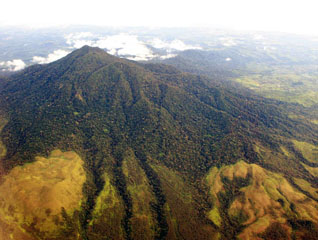
Seulawah Agam (also known as Seuleuwah Agam) volcano, one of three active stratovolcanoes in the Aceh province (>5 million inhabitants), is located at the NW tip of Sumatra. Seulawah Agam has two craters, van Heutsz (Heszt), the most active crater at an elevation of 714 m on the N flank, and Simpago on the S flank. The Indonesian Center of Volcanology and Geological Hazard Mitigation (CVGHM) reported that activity at Seulawah Agam is generally characterized by white plumes rising ˜1 m from the crater. Seulawah Agam has remained non-eruptive through at least 2 January 2013.
Historical data indicated that Seulawah Agam volcano last erupted 12-13 January 1839 on its NNE flank (van Heutsz crater). Prior to that, an eruption occurred in 1510 (˜10 years), also on its NNE flank.
During April to August 2010, the seismic data suggested increased activity overall, with marginal fluctuation. On 1 September 2010, CVGHM raised the Alert Level from I to II and restricted visitors from approaching the crater within a 3-km radius. [The 4-level Indonesian Alert Level Scale is as follows: I - Normal (green); II - Waspada or Alert (yellow); III - Siaga or Standby (orange); and IV - Awas or Aware (red).]
During October 2010-July 2011 overall activity at Seulawah Agam decreased; seismicity, water temperature, and magmatic gas emissions decreased, but pH measurements were stable and no significant changes at the surface were observed. The volcano was often shrouded in fog during this period. On 11 July 2011 the Alert Level was lowered from II to I.
Beginning on 27 December 2012 (table 3), there was an increase in deep volcanic seismicity over the course of the following week. Visual observations were often prevented due to fog, although on 2 January 2013 scientists observed a new solfatara (a natural volcanic steam vent in which sulfur gases are the dominant constituent, along with hot water vapor) that produced roaring noises and emissions which drifted ˜20 m out from van Heutsz Crater. On 3 January 2013 the Alert Level was raised from I to II; then, on 11 May 2013, the Level was lowered to I.
Table 3. Daily numbers of earthquakes measured at Seulawah Agam volcano from the week 27 Dec 2012-2 January 2013. Courtesy of CVGHM.
| Date | Deep volcanic (VA) | Shallow volcanic (VB) | Local tectonic (TL) | Long-distance tectonic (TJ) |
| 27 Dec 2012 | 4 | 1 | 3 | -- |
| 28 Dec 2012 | 8 | -- | -- | 3 |
| 29 Dec 2012 | 5 | -- | 2 | 1 |
| 30 Dec 2012 | 2 | -- | -- | 1 |
| 31 Dec 2012 | 14 | -- | 3 | 3 |
| 01 Jan 2013 | 14 | -- | 6 | 3 |
| 02 Jan 2013 | 8 | -- | 5 | 4 |
Geological Summary. Seulawah Agam at the NW tip of Sumatra is an extensively forested volcano of Pleistocene-Holocene age constructed within the large Pleistocene Lam Teuba caldera. A smaller 8 x 6 km caldera lies within Lam Teuba caldera. The summit contains a forested, 400-m-wide crater. The active van Heutsz crater, located at 650 m on the NNE flank of Suelawah Agam, is one of several areas containing active fumarole fields. Sapper (1927) and the Catalog of Active Volcanoes of the World (CAVW) reported an explosive eruption in the early 16th century, and the CAVW also listed an eruption from the van Heutsz crater in 1839. Rock et al. (1982) found no evidence for historical eruptions. However the Volcanological Survey of Indonesia noted that although no historical eruptions have occurred from the main cone, the reported NNE-flank explosive activity may have been hydrothermal and not have involved new magmatic activity.
Information Contacts: Center of Volcanology and Geological Hazard Mitigation (CVGHM), Jalan Diponegoro No. 57, Bandung 40122, Indonesia (URL: http://proxy.vsi.esdm.go.id/index.php).