Report on Gaua (Vanuatu) — May 2013
Bulletin of the Global Volcanism Network, vol. 38, no. 5 (May 2013)
Managing Editor: Richard Wunderman.
Gaua (Vanuatu) Hazard status raised; emissions continue into 2013; plume observed from above
Please cite this report as:
Global Volcanism Program, 2013. Report on Gaua (Vanuatu) (Wunderman, R., ed.). Bulletin of the Global Volcanism Network, 38:5. Smithsonian Institution. https://doi.org/10.5479/si.GVP.BGVN201305-257020
Gaua
Vanuatu
14.281°S, 167.514°E; summit elev. 729 m
All times are local (unless otherwise noted)
In our June 2012 Bulletin report (BGVN 37:06), we noted ongoing eruptions from Gaua during much of 2011. On 5 December 2011, the Vanuatu Meteorology and Geohazards Department (VMGD) changed the status of Gaua volcano from a dormant to an active volcano.
The Wellington Volcanic Ash Advisory Center (VAAC) reported that on 29 April 2013 a plume from Gaua was observed from an aircraft. Satellite imagery did not indicate ash. Astronauts on the International Space Station saw and photographed Gaua's E-blowing plume on 31 May 2013 (figure 24). During the year ending in mid-July 2013, there were no MODVOLC thermal alerts.
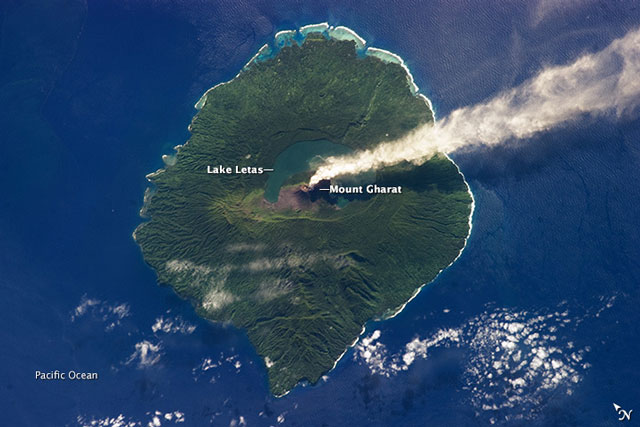 |
Figure 24. Steam plume from Gaua volcano as photographed from the International Space Station on 31 May 2013. For scale, the island is 20 km in diameter. Note N arrow at lower right. Astronaut photograph ISS036-E-5647, taken on Expedition 36 with a Nikon D3S digital camera using a 400 mm lens, and is provided by the ISS Crew Earth Observations and the Image Science & Analysis Laboratory, Johnson Space Center. The image has been cropped and enhanced to improve contrast, and lens artifacts have been removed. Original caption by William L. Stefanov, Jacobs/JETS at NASA JSC. |
The Alert Level remained at level 1 (out of 4) signifying that changes in activity could occur without, or with little, warning. VMGD continued this status through at least mid-August 2013, although they noted a slight increase in tremor since their June report. This status indicates that ashfalls will continue to be expected in areas exposed to trade winds. Strong degassing of the volcano could be accompanied by acid rainfall.
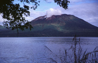
Geological Summary. The roughly 20-km-diameter Gaua Island, also known as Santa Maria, consists of a basaltic-to-andesitic stratovolcano with an 6 x 9 km summit caldera. Small vents near the caldera rim fed Pleistocene lava flows that reached the coast on several sides of the island; littoral cones were formed where these lava flows reached the ocean. Quiet collapse that formed the roughly 700-m-deep caldera was followed by extensive ash eruptions. The active Mount Garet (or Garat) cone in the SW part of the caldera has three pit craters across the summit area. Construction of Garet and other small cinder cones has left a crescent-shaped lake. The onset of eruptive activity from a vent high on the SE flank in 1962 ended a long period of dormancy.
Information Contacts: Vanuatu Geohazards Observatory (URL: http://www.vmgd.gov.vu/vmgd/); Vanuatu Meteorology and Geohazards Department (URL: http:// http://www.meteo.gov.vu/); Wellington Volcanic Ash Advisory Center (VAAC) (URL: vaac.metservice.com); and Hawai'i Institute of Geophysics and Planetology, MODVOLC Thermal Alert System, School of Ocean and Earth Science and Technology (SOEST), Univ. of Hawai'i , 2525 Correa Road, Honolulu, HI 96822 USA (URL: http://modis.higp.hawaii.edu/).