Report on Kilauea (United States) — May 2013

Bulletin of the Global Volcanism Network, vol. 38, no. 5 (May 2013)
Managing Editor: Richard Wunderman.
Kilauea (United States) Summary of highlights for 2010-2012
Please cite this report as:
Global Volcanism Program, 2013. Report on Kilauea (United States) (Wunderman, R., ed.). Bulletin of the Global Volcanism Network, 38:5. Smithsonian Institution. https://doi.org/10.5479/si.GVP.BGVN201305-332010
Kilauea
United States
19.421°N, 155.287°W; summit elev. 1222 m
All times are local (unless otherwise noted)
The following is a concise summary of reports by the U.S. Geological Survey-Hawaiian Volcano Observatory (HVO) on Kīlauea volcano covering the 3 years 2010-2012. Volcano highlights for 2009 were covered in BGVN 38:02.
Figure 209 shows a map of the lava-flow field on Kīlauea's east rift zone as of 26 July 2013. On this map some of the older lava flows are labeled with the years during which they were active. Other maps appearing in earlier Bulletin reports indicated important features such as Napau crater, Pu'u 'O'o. HVO posts both Daily and Weekly updates on Kīlauea activity (at links provided in the Information Contacts section below).
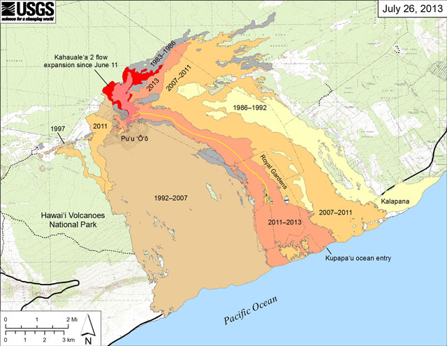 |
Figure 209. Small-scale map showing Kīlauea's east rift zone flow field as of 26 July 2013. The Peace Day flow, carried lava from the vent area to the ocean, and the inactive Kahauale'a flow from early 2013, are light reddish orange and labeled "2011-2013.". The active flow called Kahauale'a 2 flow N of Pu'u 'O'o, is shown in shades of red, with bright red showing expanded coverage since June 2011. Older lava flows are labeled with the years in which they were active. Flows during 1983-1986 (episodes 1-48b) are shown in gray; during 1986-1992 (episodes 48c-49) in pale yellow; during 1992-2007 (episode 50-55) in tan; and during 2007-2011 (episodes 58-60) in pale orange. The location of the Peace Day lava tube is shown by the yellow line, but where the tube crosses the coastal plain it has not been mapped. The interval between the contours depicting the topographic high at Pu'u 'O'o is 5 m. Courtesy of USGS/HVO. |
The Hawaiian Volcano Observatory (HVO) celebrated its centennial in January 2012 and the 30th year of Kīlauea's ongoing eruption, now active at its summit and east rift zone, on 3 January 2013.
Orr and others (2012) summarized Kīlauea's 30-year-long eruption, furnishing the following excerpt from the 2010-2012 period in that report.
Summary of 2010-2012. Regarding this interval, Orr and others (2012) made the following comments. "In January 2010 . . . the tube system broke down [enabling lava to escape from the tube] and surface flows began moving toward the east, encroaching on the Kalapana area once again. Three more houses were destroyed between July 2010 and March 2011, when the surface flows faltered.
"2011-2013: History Repeats Itself.
"Pu'u 'O'o began to refill slowly during 2010, and by early March 2011, the crater floor was within 65 feet (20 meters) of the crater's east rim. On March 5, 2011, following rapid summit deflation and increased seismicity, the crater floor of Pu'u 'O'o collapsed. Within a few hours, it had dropped 380 feet (115 meters). Shortly thereafter, lava broke to the surface between Pu'u 'O'o and Napau Crater, marking the start of the Kamoamoa fissure eruption, which was active through March 9. Reminiscent of Kīlauea's 1997 and 2007 East Rift Zone fissure eruptions, the Kamoamoa eruption cut the lava supply to the active tube, causing activity on the flow field to die.
"After 2 weeks of quiet, lava reappeared in Pu'u 'O'o on March 26, and a perched lava lake developed as the crater refilled. In late June, wholesale uplift of the crater floor raised the entire lava lake until its surface was higher than the eastern and western crater rims. Leaks from the "ring" fault bounding the uplifted area resulted in lava overflowing the crater for the first time since 2004, sending flows down the southwestern flank of Pu'u 'O'o. {Note that this is discussed further below.}
"On August 3, 2011, the crater floor of Pu'u 'O'o collapsed again when lava burst through Pu'u 'O'o's west flank, burying the western base of the cone in a massive flood of lava. The floor of the crater dropped 260 feet (80 meters), accompanied by the collapse of large slabs of rock from the crater walls into the resulting pit. The flow on the west side of Pu'u 'O'o diminished greatly after the first several hours but remained active until August 15.
"As in March, lava returned to Pu'u 'O'o within days of the August outbreak, but this time the crater filled quickly. By September 10, lava had begun to overflow the crater again, with flows spilling toward the northeast and southwest. This activity ended on September 21, when the northeastern flank of the cone fractured and lava began pouring out.
"Confined to a shallow valley between older Pu'u 'O'o flow fields, lava turned again toward the volcano's S coast. In March 2012, lava flows destroyed another house-the 214th since 1983-within the now-abandoned Royal Gardens subdivision {approximate location shown in figure 209}.
"Unlike past years, however, eruptive activity throughout 2012 was relatively weak. Lava flows were almost always active on the coastal flow field but failed to make significant forward progress. Finally, in late November, lava reached the coastline for the first time in nearly 11 months, forming a small and sporadic ocean entry. This marked the end to the longest period without an ocean entry since lava first reached the water in 1986.
"As the eruption enters its 31st year in 2013, it is showing no signs of stopping, despite the recent slow down in activity. What Kīlauea Volcano has in store next remains to be seen. Although recent patterns suggest continued activity on the East Rift Zone, this could change abruptly. Even a return to Kīlauea's more explosive past is possible (see USGS Fact Sheet 2011-3064, Kīlauea-an Explosive Volcano in Hawai'i, available at http://pubs.usgs.gov/fs/2011/3064 {Swanson and others, 2011}). What is certain is that Kīlauea will remain an active volcano for millennia to come."
More details on 2010-2012 events. HVO reporting disclosed events presented below (tables 6-8), including a brief summary of 2010-2012 events (table 5), a broad overview of the eruption during 2007-2012 (table 6), and several of the notable collapses during 2010-2011 (table 7).
Table 6. Brief summary of events at Kīlauea during the period 2010-2012. Courtesy of various USGS/HVO reports (periodic, fact sheets, etc.).
| Date(s) | Event |
| 04 Jan 2010 | Cessation of Waikupanaha ocean entry after 22 months |
| 25 Jan-10 Mar 2010 | Persistent flow through Royal Gardens and out onto the coastal plain |
| Feb or Mar 2010 | Small collapse of E wall Pu'u 'O'o crater rim |
| 29 Apr-30 Nov 2010 | New ocean entries of lava at Ki, Puhi-o-Kalaikini, and 'Ili'ili |
| May, Jul, and Aug 2010 | Portions of N rim of Pu'u 'O'o fall into crater |
| May-Jun 2010 | Lava erupted on S wall and NE side of Pu'u 'O'o crater |
| Late July, 27 Nov 2010 | 2 houses destroyed in Kalapana Gardens subdivision |
| Sep-Dec 2010 | Eruption of vent on W edge of Pu'u 'O'o crater |
| Nov 2010-Feb 2011 | Increase in long-term inflation of Pu'u 'O'o crater |
| 2011 | East rift zone eruption episodes 58-61 (see Table 6) |
| Jan, early Feb 2011 | Ocean entries at 2 previous areas, Puhi-o-Kalaikini and Ki |
| 17 Feb 2011 | House destroyed in Kalapana Gardens subdivision |
| 05 Mar 2011 | Beginning of eruption Episode 59 (see table 6); floor of Pu'u 'Æ crater began collapsing; new fissures opened between Napau Crater and Pu'u 'O'o |
| 26 Mar 2011 | Beginning of eruption Episode 60 (see table 6); lava filled collapse crater of Pu'u 'O'o and uplifted lake floor |
| 24 July 2011 | Lava flow from ring fracture along SW margins of Pu'u 'O'o crater |
| 03 Aug 2011 | Lava lake draining through from lower W flank of Pu'u 'O'o; lake completely drained within several hours, leaving a rubble-filled depression ~80 m below its pre-collapse level |
| 20 Aug 2011 | Beginning of eruption Episode 61; Pu'u 'O'o refilled and overflowed |
| 21 Sep 2011 | Lava broke through the upper E flank of the Pu'u 'O'o cone; Pu'u 'O'o crater subsided ~20 m; flow (Peace Day flow) resulted in a channelized 'a'a' flow to SW |
| 22 Sep 2011 | Channelized 'a'a' flow stalled; fissure and open channel crusted over by mid-Oct 2011 |
| 09 Dec 2011 | Flow reached ocean entry by evening 9 Dec 2011 |
| 2012 | Peace Day flow continued to be active |
| Early 2012 | Subsidence in Pu'u 'O'o crater continued; outgassing events on crater floor |
| 02 Mar 2012 | House in Royal Gardens subdivision destroyed |
| End of Aug 2012 | Deflation phase led to lowering of lava lake beneath Pu'u 'O'o crater ; lava began erupting and filled in NW pit by Sep 2012. |
Table 7. An overview of the Kīlauea East Rift Zone (ERZ) eruption during 2007-2012 (eruption episodes 57-61) including (from left) episodes, dates, (approximate in some cases) vent locations, and estimated volume of erupted material. HVO subdivides 30-year-long Pu`u `O`o eruption into episodes. Each new episode denotes vigorous new eruptive activity either from a different vent or commencing after a pause or slowdown. Some episodes are well defined; others more arbitrary. The day and time of various episodes may vary slightly with different instrumentation. The dates in the table signify the duration of the episode or episodes. Courtesy of M. Patrick (USGS) and various USGS/HVO reports.
| Dates | Episode(s) | Vent location | Est. volume (km3) |
| 1 Jul 2007-5 Mar 2011 | 57-58 | Crater fill and fissures E of Pu'u 'O'o | 0.63 |
| 05 Mar-09 Mar 2011 | 59 | Kamoamoa fissures | 0.003 |
| 26 Mar-15 Aug 2011 | 60 | Pu'u 'O'o overflows and W flank vent | 0.04 |
| 20 Aug 2011-present | 61 | Pu'u 'O'o overflows and Peace Day flow | 0.15 |
Table 8. For Kīlauea, a list containing several notable collapses and/or explosive events during 2010-2011. Courtesy of various USGS/HVO reports and Matthew Patrick, USGS/HVO.
| Date | Time (HST) | Notes |
| 11 Feb 2010 | 1551 | Collapse in vent; continuous lava lake started |
| 26 Apr 2010 | 1409 | Collapse in vent; lava lake doubled in size |
| 17 Jan 2011 | 2311 | Series of explosions |
| 21 Jan 2011 | 1430 | Explosion |
| 14 Feb 2011 | 0908 | Series of explosions |
| 15 Feb 2011 | 0305 | Series of explosions |
| 20 Feb 2011 | 0049 | Explosion |
| 03 Mar 2011 | 1236 | Series of explosions |
| 21 Dec 2011 | 1655 | Explosion |
30-year long eruption summary comments. Table 9 and figure 210 present general information about the total 30-yr eruption period.
Table 9. Selected eruption statistics for the entire 30-year during 1983 to January 2013. Courtesy of Orr and others (2013) and various USGS/HVO reports.
| Feature | Statistic |
| Area covered | 125.5 km2 |
| New land on coast | 2.02 km2 |
| Volume erupted (dense rock equivalent) | ~4 km3 |
| Thickness along coast | 10 to 35 m |
| Pre-1983 area covered in 2012 | 0.4 km2 |
| Net total of land added to the island (Nov 1986–Dec 2012) | 2.015 km2 |
| Coastal highway covered by lava | 14.3 km |
| Structures destroyed | 214 |
| Pu'u 'O'o maximum height | 255 m in 1987; 171 m in 2012 |
| Pu'u 'O'o crater size | 300-450 m |
Satellite images. To provide a comparison, NASA Earth Observatory prepared both a natural-color satellite image from 6 June 2011 (figure 210a), and a black-and-white aerial photograph from 25 March 1977 (figure 210b). As the authors noted, the images both show the landscape surrounding Napau Crater and Pu'u 'O'o. Lava flows that are more than a century old are covered by a dense forest of ohia lehua and tree ferns forest (green in the 2011 image). Flows from eruptions in 1965, 1968, and 1969 are much lighter than the forest in the 1977 image, but difficult to differentiate from one another. By comparison, the 2011 image shows profound changes in the landscape.
Weathered lava from the initial Napau Crater vent is almost indistinguishable from the older (1968 and 1969) lavas that cover most of the crater floor. In January 1997, a fresh line of fissures opened within Napau Crater, erupting lava during Episode 54 of the Pu'u 'O'o-Kupaianaha eruption. Additional cracks and fissures split the earth between Napau Crater and Pu'u 'O'o in the March 2011 Kamoamoa Fissure Eruption (Episode 59), spreading black lava through the forest. Scorched forest appears reddish-brown along the edges of the lava flows. Since 9 March 2011, lava flows have originated from Pu'u 'O'o(figure 210a, upper right). A lava pond is visible within the crater, and a system of lava tubes carries molten rock underground to the southeast. Brown lavas surrounding the crater flowed directly from the lava pond.
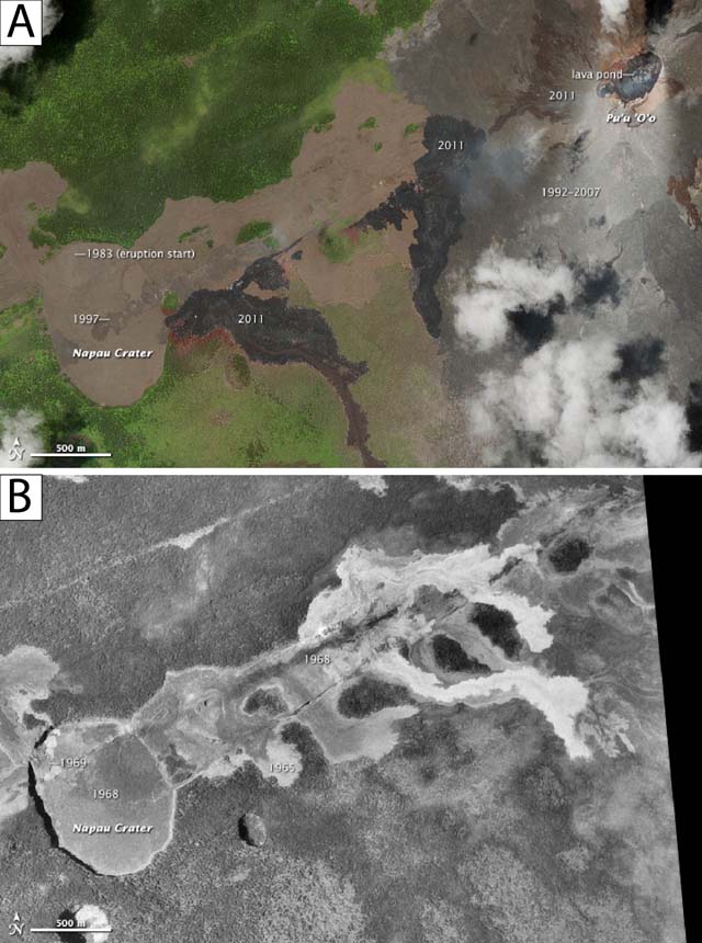 |
Figure 210. Two images-a natural-color satellite image from June 6, 2011 (A), and a black-and-white aerial photograph from March 25 (B), 1977-show the landscape surrounding Napau Crater and Pu'u 'O'o. Lavas of different ages cover the surface. Lava flows that are more than a century old are covered by a dense forest (green in the 2011 image) of ohia lehua and tree ferns. Flows from eruptions in 1965, 1968, and 1969 are much lighter than the forest in the 1977 image, but difficult to differentiate from one another. The 2011 image shows dramatic changes in the landscape. Weathered lava from the initial Napau Crater vent is almost indistinguishable from the older (1968 and 1969) lavas that cover most of the crater floor. In January 1997, a fresh line of fissures opened within Napau Crater, erupting lava during episode 54 of the Pu'u 'O'o-Kupaianaha eruption. Additional cracks and fissures split the earth between Napau Crater and Pu'u 'O'o in the March 2011 Kamoamoa Fissure Eruption (Episode 59), spreading black lava through the forest. Scorched forest appears reddish-brown along the edges of the lava flows. Since 9 March 2011, lava flows have originated from Pu'u 'O'o (image upper right). A lava pond is visible within the crater, and a system of lava tubes carries molten rock underground to the southeast. Brown lavas surrounding the crater flowed directly from the lava pond. Images taken from Simmon (2012). |
References. Orr, T., Heliker, C., and Patrick, M., 2012, The ongoing Pu'u'O'o eruption of Kīlauea Volcano, Hawai'i-30 years of eruptive activity, U.S. Geological Survey Fact Sheet 2012-3127, 6 p. (URL: http://pubs.usgs.gov/fs/2012/3127/; accessed 15 August 2013).
Simmon, R., 2012, 30th Anniversary of the Pu'u 'O'o Eruption on Kīlauea, NASA Earth Observatory (URL: http://earthobservatory.nasa.gov/NaturalHazards/view.php?id=80091).
Swanson, D., Fiske, D., Rose, T., Houghton, B, and Mastin, L., 2011, Kīlauea-an explosive volcano in Hawai'i, U.S. Geological Survey Fact Sheet 2011-3064, 4 p (URL: http://pubs.usgs.gov/fs/2011/3064/; accessed 15 August 2013).
USGS/HVO, 2012, Kīlauea's east rift zone (Pu'u 'O'o) eruption 1983 to present, 13 April 2012, 14 p. (URL: http://hvo.wr.usgs.gov/kilauea/summary/#Mar2011; accessed 15 August 2013).
USGS/HVO, 2013, Maps, July 26, 2013 - Kīlauea, Kīlauea's east rift zone flow field, web site (URL: http://www.wr.usgs.gov/maps; accessed 15 August 2013).
Geological Summary. Kilauea overlaps the E flank of the massive Mauna Loa shield volcano in the island of Hawaii. Eruptions are prominent in Polynesian legends; written documentation since 1820 records frequent summit and flank lava flow eruptions interspersed with periods of long-term lava lake activity at Halemaumau crater in the summit caldera until 1924. The 3 x 5 km caldera was formed in several stages about 1,500 years ago and during the 18th century; eruptions have also originated from the lengthy East and Southwest rift zones, which extend to the ocean in both directions. About 90% of the surface of the basaltic shield volcano is formed of lava flows less than about 1,100 years old; 70% of the surface is younger than 600 years. The long-term eruption from the East rift zone between 1983 and 2018 produced lava flows covering more than 100 km2, destroyed hundreds of houses, and added new coastline.
Information Contacts: Hawaiian Volcano Observatory (HVO), U.S. Geological Survey, PO Box 51, Hawai'i National Park, HI 96718, USA (URL: https://volcanoes.usgs.gov/observatories/hvo/, Daily updates, https://volcanoes.usgs.gov/observatories/hvo/activity/kilaueastatus.php, and Weekly updates, https://volcanoes.usgs.gov/observatories/hvo/volcanowatch/).