Report on Chaiten (Chile) — August 2013

Bulletin of the Global Volcanism Network, vol. 38, no. 8 (August 2013)
Managing Editor: Richard Wunderman.
Edited by Julie A. Herrick.
Chaiten (Chile) Declining seismicity, thermal emissions, and plumes during 2013
Please cite this report as:
Global Volcanism Program, 2013. Report on Chaiten (Chile) (Herrick, J.A., and Wunderman, R., eds.). Bulletin of the Global Volcanism Network, 38:8. Smithsonian Institution. https://doi.org/10.5479/si.GVP.BGVN201308-358041
Chaiten
Chile
42.8349°S, 72.6514°W; summit elev. 1122 m
All times are local (unless otherwise noted)
In this report, we cover declining activity observed at Chaitén during 2012-2013. The Servicio Nacional de Geología y Minería (SERNAGEOMIN) had reduced the Alert Level to Green on 2 May 2011 (BGVN 36:11) and continued to monitor activity and release online bulletins. These activity bulletins were available during February 2012-October 2013. We also note the thermal alerts from MODVOLC during January 2010-April 2013.
The recent rhyolitic eruption of Chaitén began in May 2008 (BGVN 33:04) and, according to Pallister and others (2013), comprised five major phases: (1) an explosive sequence (1-11 May 2008), (2) a transitional time that included ash plumes and lava extrusion (11-31 May 2008), (3) lava flows and dome growth (June-September 2008), (4) spine extrusion and dome growth (October 2008-February 2009), and (5) endogenous lava dome growth (February 2009-early 2010). Following those phases of activity, ash plumes and thermal emissions declined during 2010-2011 (figure 31); intermittent thermal anomalies and vapor emissions dominated activity during 2011-April 2013. Since April 2013, thermal alerts were no longer reported by the MODVOLC system.
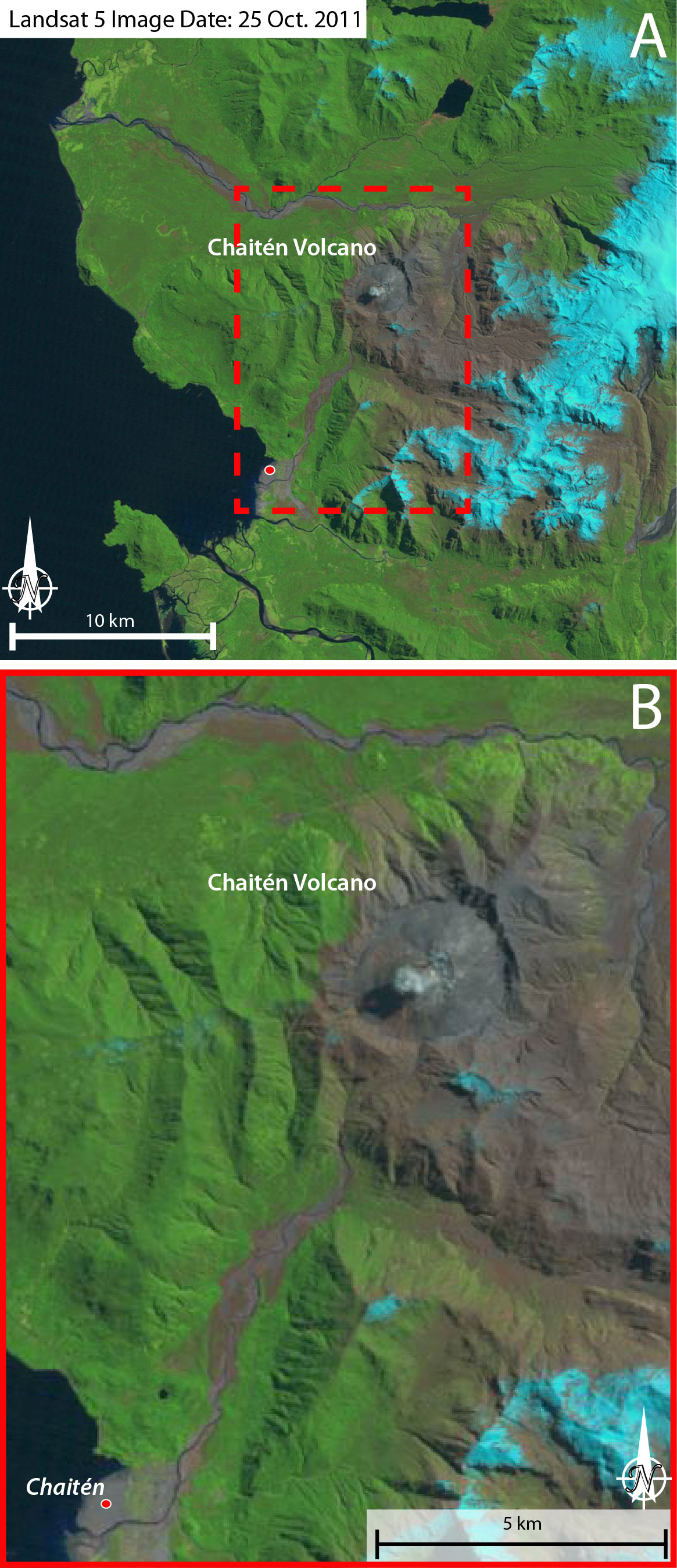 |
Figure 31. On 25 October 2011, this Landsat 5 image captured a small plume rising from Chaitén's active lava dome. A) This wideview includes the caldera and surrounding region of Chaitén. Meandering river systems link the volcanic highlands with the Pacific coast. A) and B) The town of Chaitén is located at the red circle, on the delta formed by runoff from the highlands that include Chaitén ~11 km NE. Note that the scale bars are approximate. Courtesy of USGS/NASA. |
SERNAGEOMIN reported decreasing seismicity during 2012-2013 (table 3). Volcano-tectonic (VT) events dominated these datasets while hybrid events were very rare. Local magnitudes (ML) and magnitudes calculated from signal duration (MD) were reported as well as the reduced displacement (calculated for long-period earthquakes).
Table 3. Seismicity during February 2012-September 2013 is reported for total earthquake counts (EQ), volcano-tectonic earthquakes (VT), long-period earthquakes (LP), and hybrid (HYB). Note that "**" indicates reporting of ML values where MD values were not reported. Reduced displacement (RD) is reported for LP events. Courtesy of SERNAGEOMIN.
| Date | EQ | VT | Max ML | LP | MD | RD cm2 | HYB | MD |
| Feb 2012 | 226 | 170 | 1.9 | 54 | 1.8 | 4.0 | 2 | 1.3 |
| Mar 2012 | 303 | 216 | 3.0 | 86 | 0.6 | 9.3 | 0 | 0 |
| Apr 2012 | 179 | 106 | 1.8 | 73 | 2 | 2.3 | 0 | 0 |
| May 2012 | 109 | 47 | 2.3 | 62 | 1.6 | 58.2 | 0 | 0 |
| Jun 2012 | 47 | 22 | 1.6 | 25 | 1 | 5.4 | 0 | 0 |
| Jul 2012 | 93 | 63 | 2.8 | 30 | 1.7 | 0.5 | 0 | 0 |
| Aug 2012 | 96 | 72 | 2.5 | 23 | 2.3 | 9.6 | 0 | 0 |
| Sep 2012 | 56 | 41 | 2.5 | 15 | 0.5 | 0.1 | 0 | 0 |
| Oct 2012 | 49 | 39 | 1.9 | 10 | 2.3 | 3 | 0 | 0 |
| Nov 2012 | 61 | 49 | 1.9 | 12 | 1.9 | 7.4 | 0 | 0 |
| Dec 2012 | 45 | 42 | 2.7 | 3 | 1.7 | 1.1 | 0 | 0 |
| Jan 2013 | 76 | 55 | 2.9 | 16 | 2.3 | 11.4 | 5 | -- |
| Feb 2013 | 43 | 28 | 1.7 | 15 | -- | 0.8 | 0 | 0 |
| Mar 2013 | 5 | 4 | 1.0 | 1 | -- | 1.7 | 0 | 0 |
| Apr 2013 | -- | -- | -- | -- | -- | -- | -- | -- |
| May 2013 | 53 | 44 | 1.9 | 11 | 1.6** | 3.8 | -- | -- |
| Jun 2013 | -- | -- | -- | -- | -- | -- | -- | -- |
| Jul 2013 | 67 | 50 | 0.8 | 17 | 1.3** | 5.6 | -- | -- |
| Aug 2013 | 38 | 29 | 1.4 | 8 | 1.3** | 6.4 | 1 | 2.0** |
| Sep 2013 | 5 | 5 | 1.3 | -- | -- | -- | -- | -- |
| Oct 2013 | 30 | 21 | 2.4 | 9 | 1.7** | -- | -- | -- |
When clear viewing conditions permitted, nighttime incandescence and vapor plumes were captured by the SERNAGEOMIN webcamera during February 2012-September 2013. Observations included plume heights ranging 300-600 m above the crater.
Thermal alerts. Elevated temperatures were detected from Chaitén during much of the eruption that began in May 2008. Thermal anomalies were detected by MODIS sensors on the Terra and Aqua satellites every month until September 2010 (table 4). As the eruption waned, elevated temperatures were observed less often and were absent during the months of July 2011, May 2012, August-October 2012, December 2012, March 2013, and after 2 April 2013. The MODVOLC alerts chiefly occurred in the immediate area of the crater (figure 32).
Table 4. The MODVOLC system generated alerts during January 2010-April 2013. The number of thermal alerts detected per year decreased from 2010 through early 2013. Courtesy of HIGP.
| Date | Days/Month | Pixels/Month |
| Jan 2010 | 5 | 5 |
| Feb 2010 | 7 | 9 |
| Mar 2010 | 7 | 9 |
| Apr 2010 | 6 | 6 |
| May 2010 | 4 | 4 |
| Jun 2010 | 1 | 1 |
| Jul 2010 | 2 | 2 |
| Aug 2010 | 3 | 3 |
| Sep 2010 | 0 | 0 |
| Oct 2010 | 3 | 3 |
| Nov 2010 | 1 | 1 |
| Dec 2010 | 4 | 4 |
| Jan 2011 | 6 | 6 |
| Feb 2011 | 7 | 7 |
| Mar 2011 | 1 | 1 |
| Apr 2011 | 4 | 4 |
| May 2011 | 3 | 3 |
| Jun 2011 | 3 | 3 |
| Jul 2011 | 1 | 1 |
| Aug 2011 | 1 | 1 |
| Sep 2011 | 2 | 2 |
| Oct 2011 | 4 | 4 |
| Nov 2011 | 1 | 1 |
| Dec 2011 | 9 | 9 |
| Jan 2012 | 7 | 7 |
| Feb 2012 | 2 | 2 |
| Mar 2012 | 3 | 4 |
| Apr 2012 | 2 | 2 |
| May 2012 | 0 | 0 |
| Jun 2012 | 3 | 3 |
| Jul 2012 | 2 | 3 |
| Aug 2012 | 0 | 0 |
| Sep 2012 | 0 | 0 |
| Oct 2012 | 0 | 0 |
| Nov 2012 | 2 | 2 |
| Dec 2012 | 0 | 0 |
| Jan 2013 | 3 | 3 |
| Feb 2013 | 2 | 2 |
| Mar 2013 | 0 | 0 |
| Apr 2013 | 1 | 1 |
| May 2013 | 0 | 0 |
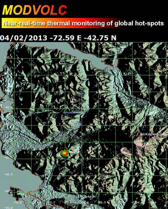 |
Figure 32. As seen here, from April 2012 to April 2013, MODVOLC generated alerts (red and orange point) on 15 days for Chaitén. Those alerts indicated elevated temperatures within 2 km of the summit area. Courtesy of HIGP. |
References. NASA Landsat Program, 2011, Landsat ETM scene LT52320902011298COA00, SLC-Off, USGS, Sioux Falls, October 25, 2011.
Pallister, J.S., Diefenbach, A.K., Burton, W.C., Muñoz, J., Griswold, J.P., Lara, L.E., Lowenstern, J.B., and Valenzuela, C., 2013, The Chaitén rhyolite lava dome: Eruption sequence, lava dome volumes, rapid effusion rates and source of the rhyolite magma, Andean Geology, 40, (2): 277-294.
Geological Summary. Chaitén is a small caldera (~3 km in diameter) located 10 km NE of the town of Chaitén on the Gulf of Corcovado. Multiple explosive eruptions throughout the Holocene have been identified. A rhyolitic obsidian lava dome occupies much of the caldera floor. Obsidian cobbles from this dome found in the Blanco River are the source of artifacts from archaeological sites along the Pacific coast as far as 400 km from the volcano to the N and S. The caldera is breached on the SW side by a river that drains to the bay of Chaitén. The first recorded eruption, beginning in 2008, produced major rhyolitic explosive activity and building a new dome and tephra cone on the older rhyolite dome.
Information Contacts: Observatorio Volcanológico de los Andes del Sur-Servicio Nacional de Geologia y Mineria (OVDAS-SERNAGEOMIN), Avda Sta María No. 0104, Santiago, Chile (URL: http://www.sernageomin.cl/); and Hawai'i Institute of Geophysics and Planetology (HIGP) MODVOLC Thermal Alerts System, School of Ocean and Earth Science and Technology (SOEST), Univ. of Hawai'i, 2525 Correa Road, Honolulu, HI 96822, USA (URL: http://modis.higp.hawaii.edu/).