Report on Mayon (Philippines) — September 2013

Bulletin of the Global Volcanism Network, vol. 38, no. 9 (September 2013)
Managing Editor: Richard Wunderman.
Mayon (Philippines) Quiet during May 2013-November 2013; super-typhoon and lahars
Please cite this report as:
Global Volcanism Program, 2013. Report on Mayon (Philippines) (Wunderman, R., ed.). Bulletin of the Global Volcanism Network, 38:9. Smithsonian Institution. https://doi.org/10.5479/si.GVP.BGVN201309-273030
Mayon
Philippines
13.257°N, 123.685°E; summit elev. 2462 m
All times are local (unless otherwise noted)
Following the phreatic eruption on 7 May 2013 that killed 7 climbers (BGVN 38:04), there has been little increase in volcanic activity at Mayon volcano. Seismicity has mostly receded to baseline levels, aside from occasional volcanic earthquakes. These earthquakes occur about once every other day, with minimal earthquakes in June and September. The activity reported by the Philippine Institute of Volcanology and Seismology (PHIVOLCS) in table 12 below represents a continuation of table 11 from a previous Bulletin report (BGVN 34:12). Rockfalls and earthquakes are plotted in figure 22.
Table 12. Almost daily summaries of observations at Mayon, including seismicity and SO2emission rates during 1 June -23 November 2013. Number of events represent counts from the seismic monitoring network over a 24-hour period prior to the stated reporting date/time (except as noted). For example RF: 1 means 1 rockfall; and VE: 2 means 2 volcanic earthquakes. Rockfall events are related to the detachment of lava fragments at the volcano's upper slopes. No ash explosions were recorded during this time period. SO2 emission rates, measured by FLYSPEC [a miniature, light-weight ultraviolet correlation spectrometer (Horton and others, 2006)], are for the day before the reporting date. Courtesy of PHIVOLCS.
| Report Date(local time), 2013 | Volcanic earthquakes (VE) and rockfalls (RF) | SO2 flux (tonnes/day) |
| 01 June | -- | 131 |
| 02 June | RF: 1 | -- |
| 05 June | VE: 1 | -- |
| 07 June | RF: 1 | -- |
| 10 June | VE: 1 | -- |
| 13 June | VE: 1 | -- |
| 14 June | -- | 133 |
| 18 June | VE: 1 | -- |
| 01 July | RF: 2 | -- |
| 02 July | VE: 1 | -- |
| 05 July | VE: 2 | -- |
| 13 July | VE: 1 RF: 2 | -- |
| 17 July | VE: 2 | -- |
| 18 July | VE: 2 RF: 1 | -- |
| 19 July | VE: 2 | -- |
| 21 July | VE: 1 | -- |
| 27 July | VE: 1 | -- |
| 28 July | VE: 2 | -- |
| 31 July | VE: 2 | -- |
| 01 August | RF: 1 | -- |
| 02 August | RF: 1 | -- |
| 05 August | VE: 1 | -- |
| 06 August | VE: 1 | -- |
| 07 August | VE: 2 | -- |
| 08 August | VE: 2 | -- |
| 09 August | VE: 2 | -- |
| 11 August | VE: 2 | -- |
| 14 August | -- | 322 |
| 16 August | VE: 1 | -- |
| 21 August | VE: 1 | -- |
| 23 August | VE: 1 | 107 |
| 24 August | VE: 1 | -- |
| 30 August | -- | 183 |
| 10 September | -- | 218 |
| 17 September | VE: 1 | -- |
| 28 September | VE: 1 | |
| 02 October | VE: 1 | -- |
| 03 October | VE: 1 | -- |
| 05 October | VE: 3 | -- |
| 07 October | VE: 1 | -- |
| 09 October | VE: 1 | 159 |
| 10 October | VE: 1 | -- |
| 13 October | VE: 1 | -- |
| 16 October | -- | 466 |
| 22 October | VE: 1 | 260 |
| 23 October | VE: 1 | -- |
| 24 October | VE: 2 | -- |
| 25 October | -- | 84 |
| 31 October | VE: 4 | -- |
| 13 November | VE: 2 | -- |
| 15 November | VE: 1 | -- |
| 17 November | VE: 1 | -- |
| 18 November | VE: 1 | -- |
| 19 November | VE: 1 | -- |
| 20 November | VE: 1 | -- |
| 21 November | VE: 3 | -- |
| 22 November | VE: 2 | -- |
| 23 November | VE: 5 | 211 |
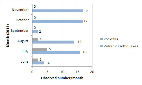 |
Figure 22. Graph showing distribution of volcanic earthquakes and rockfalls from June 2013 to November 2013. Created by Bulletin editors from PHIVOLCS reports. |
When cloud cover and heavy rain does not inhibit observations, PHIVOLCS had consistently recorded white steam plumes that drifted in various directions from June to November 2013. Bluish fumes, a sign of hydrogen sulfide, were witnessed on 5 and 7 June, 15 and 23 August, and 7 and 28 September. Ground deformation surveys in the second week of August showed that the inflationary trend was continuing. In May 2013, electronic tilt meters measured Mayon's edifice to be slightly inflated compared to January 2010.
Crater glow of Intensity 1 was observed numerous times from June to September. According PHIVOLCS, a crater glow of Intensity 1 is faint, Intensity 2 is more visible to the naked eye, Intensity 3 is bright, and Intensity 4 is intense. Crater glow likely results from incandescence of new lava, or newly exposed lava, reflecting off local crater walls, clouds, or steam.
PHIVOLCS interprets enhanced crater glow as a sign of SO2 clouds, but there had been little SO2 fluctuation from June to November. Mayon's Alert status remained at Level 1 following the increase from Level 0 on 31 May 2013. However, PHIVOLCS continues to advise residents and visitors to avoid the 6-kilometer radius Permanent Danger Zone (PDZ) due to hazards such as rockfalls, landslides, sudden ash emissions, and phreatic eruptions. Level 1 is the 2nd value on a scale from 0 to 5, with 5 signifying an ongoing hazardous eruption; level 1 indicates an abnormal condition, but no magmatic eruption is imminent.
On 6 November 2013, PHIVOLCS issued a warning for super-typhoon Haiyan, locally known as Yolanda, indicating that excessive rainfall might trigger landslides and lahars at Mayon. Peak winds during Haiyan were consistently 170 mph, making the storm a super-typhoon as classified by NOAA ("maximum sustained 1-minute surface winds of at least [150 miles per hour]"). With the potential of large-magnitude lahars, the province of Albay started an evacuation of about 103,200 people along areas downstream, as shown in figure 23. According to the news source, Inquirer, adjacent communities, including Guinobatan, Legaspi City, Sto. Domingo, Daraga and Ligao City, were at risk for inundation, burial and washout. PHIVOLCS also issued precautions concerning debris flows from landslides of Mt. Masaraga, an old volcanic edifice N of Mayon.
 |
Figure 23. Super-typhoon Haiyan left destruction in its wake after hitting the Philippines in early November. In this photo from the Associated Press, residents downstream from Mayon were evacuated due to the possibility of lahars engulfing nearby communities (Daily Mail). |
Geological Summary. Symmetrical Mayon, which rises above the Albay Gulf NW of Legazpi City, is the most active volcano of the Philippines. The steep upper slopes are capped by a small summit crater. Recorded eruptions since 1616 CE range from Strombolian to basaltic Plinian, with cyclical activity beginning with basaltic eruptions, followed by longer term andesitic lava flows. Eruptions occur predominately from the central conduit and have also produced lava flows that travel far down the flanks. Pyroclastic flows and mudflows have commonly swept down many of the approximately 40 ravines that radiate from the summit and have often damaged populated lowland areas. A violent eruption in 1814 killed more than 1,200 people and devastated several towns.
Information Contacts: Philippine Institute of Volcanology and Seismology (PHIVOLCS); Associated Press (URL: http://www.ap.org/); Daily Mail (URL: http://www.dailymail.co.uk); NOAA (URL: http://www.aoml.noaa.gov); and Philippine Daily Inquirer (URL: http://www.inquirer.net/).