Report on Cerro Negro (Nicaragua) — October 2013
Bulletin of the Global Volcanism Network, vol. 38, no. 10 (October 2013)
Managing Editor: Richard Wunderman.
Edited by Julie A. Herrick.
Cerro Negro (Nicaragua) Seismic swarm in 2013
Please cite this report as:
Global Volcanism Program, 2013. Report on Cerro Negro (Nicaragua) (Herrick, J.A., and Wunderman, R., eds.). Bulletin of the Global Volcanism Network, 38:10. Smithsonian Institution. https://doi.org/10.5479/si.GVP.BGVN201310-344070
Cerro Negro
Nicaragua
12.506°N, 86.702°W; summit elev. 728 m
All times are local (unless otherwise noted)
Since our last report (BGVN 37:01), Instituto Nicaragüense de Estudios Territoriales (INETER) continued to conduct fieldwork at Cerro Negro during 2012-2013 and reported that stable conditions prevailed except for a small seismic swarm detected in 2013.
INETER reported that from Cerro Negro's activity during 2012 was considered normal. Several significant landslides occurred that year, particularly from the S-SW interior rim of the primary crater. Seismicity was variable throughout the year with some interruptions of the signal (table 5).
Table 5. Seismicity was reported in INETER monthly reports during January-June 2012. Note that representative values are presented in the RSAM column (not mathematical averages) whereas the Max RSAM column contains the highest value recorded each month. There was a station outage during part of January. Courtesy of INETER.
| Month | EQ Count | RSAM | Max RSAM | Tremor (hours/day) |
| Jan 2012 | 43 | ~20 | 160 | -- |
| Feb 2012 | 85 | ~20 | 80 | 3-18 |
| Mar 2012 | 76 | ~50 | 255 | 1-16 |
| Apr 2012 | 162 | ~20 | 50 | 1-15 |
| May 2012 | 111 | 12-30 | 65 | some |
| Jun 2012 | 179 | 10-20 | 45 | 1 |
A gas measurement campaign was conducted within Cerro Negro's main crater in collaboration with the Instituto Tecnologicos de Energias Renovables (ITER) in late 2012. During the course of fieldwork, on 26 and 30 November, and 1 December, the team measured diffuse CO2 emissions from the soil at 219 points. The preliminary results showed normal levels, ~33 tons per day, compared to past results from this area.
Temperature measurements for 2012 were reported based on the four different fumarolic sites within the main crater (figure 20). The range varied between 50 and 325 degrees C.
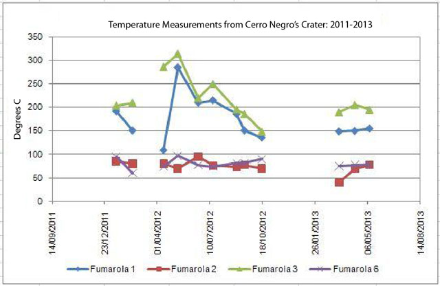 |
Figure 20. Temperature measurements from Cerro Negro's crater summarized for 2011-2013. Data were collected December 2011-May 2013. Four different fumaroles were sampled and measured (fumaroles 1, 2, 3, and 6; for locations see figure 21). The data were collected at intervals of days and many are shown here (as in the original INETER plot) connected with line segments. Courtesy of INETER. |
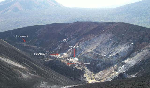 |
Figure 21. The location of the four measured fumaroles located within Cerro Negro's largest crater. The view is approximately to the N. Courtesy of INETER. |
Field investigations during March-June 2013 yielded additional observations of rockfalls and slides within the main crater. INETER also measured temperatures from the four fumarolic sites and concluded that steady conditions persisted (figure 20).
INETER reported a seismic swarm on 4 June 2013. RSAM had increased 60 units; 49 earthquakes were detected but were too small to be located. INETER maintained Alert Status Green and released informational statements to the media that described their response to the escalation and they also highlighted the potential of hazardous gas emissions for the area. The Sistema Nacional para Prevención, Mitigación y Atención de Desastres (SINAPRED) suggested that local residents and tourists in the area should be cautious around the flanks of Cerro Negro due to the possibility of rockfalls triggered by seismic events.
As a response to the increased seismicity that month, INETER conducted hot spring sampling and gas measuring campaigns in the area of Cerro Negro during 6-7 June. A team of fieldworkers focused on diffuse CO2 flux from the soil in a fault area on the W side of the Las Pilas-El Hoyo complex (SE of Cerro Negro, figure 15 in BGVN 37:01). The team took measurements 5 m apart at 91 points along a fault scarp, with depths of 11 and 40 cm within the soil; those measurements indicate an average flux of 59-80 ppm/s. No additional seismic unrest was reported during the month.
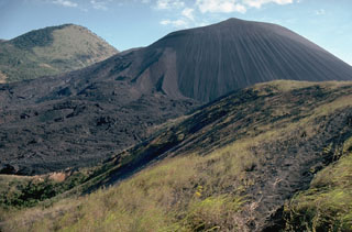
Geological Summary. Nicaragua's youngest volcano, Cerro Negro, was created following an eruption that began in April 1850 about 2 km NW of the summit of Las Pilas volcano. It is the largest, southernmost, and most recent of a group of four youthful cinder cones constructed along a NNW-SSE-trending line in the central Marrabios Range. Strombolian-to-subplinian eruptions at intervals of a few years to several decades have constructed a roughly 250-m-high basaltic cone and an associated lava field constrained by topography to extend primarily NE and SW. Cone and crater morphology have varied significantly during its short eruptive history. Although it lies in a relatively unpopulated area, occasional heavy ashfalls have damaged crops and buildings.
Information Contacts: Instituto Nicaragüense de Estudios Territoriales (INETER), Apartado Postal 2110, Managua, Nicaragua (URL: http://www.ineter.gob.ni/); Instituto Tecnológico y de Energías Renovables (ITER), 38611 Granadilla, Tenerife, Canary Islands, Spain (URL: http://www.iter.es/); Hoy: El Periodico que yo quiero, Managua, Nicaragua (URL: http://www.hoy.com.ni/2013/06/05/vigilan-al-volcán-cerro-negro/); and Sistema Nacional para Prevención, Mitigación y Atención de Desastres (SINAPRED), Managua, Nicaragua (URL: http://www.sinapred.gob.ni/).