Report on Ritter Island (Papua New Guinea) — February 2014
Bulletin of the Global Volcanism Network, vol. 39, no. 2 (February 2014)
Managing Editor: Richard Wunderman.
Ritter Island (Papua New Guinea) Report includes past geothermal activity observations
Please cite this report as:
Global Volcanism Program, 2014. Report on Ritter Island (Papua New Guinea) (Wunderman, R., ed.). Bulletin of the Global Volcanism Network, 39:2. Smithsonian Institution. https://doi.org/10.5479/si.GVP.BGVN201402-251070
Ritter Island
Papua New Guinea
5.519°S, 148.115°E; summit elev. 75 m
All times are local (unless otherwise noted)
According to the Rabaul Volcanological Observatory, a "small (probably submarine) eruption was reported to have taken place at Ritter Island on 18 April 2014 (figures 2 and 3). At about 1700 hours, an earthquake was felt at Kampalap village on Umboi Island. At the same time the level of sea rose a little over normal but was confined to the beach at Kampalap. At around 0000 hours on 19 April, another felt earthquake occurred. The earthquakes were estimated to have an intensity at Kampalap of between II to III. No floating debris where seen, and no ash or damage was reported."
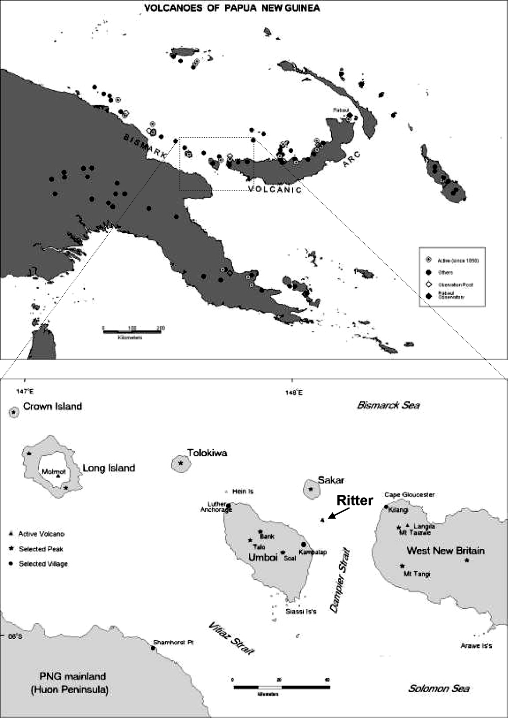 |
Figure 2. Location maps for Ritter Island. The upper map shows the region of Papua New Guinea containing Ritter Island and other volcanoes, and the lower map is enlargement of the center of the upper map focused on Ritter Island. From Saunders and Kuduon (2009). |
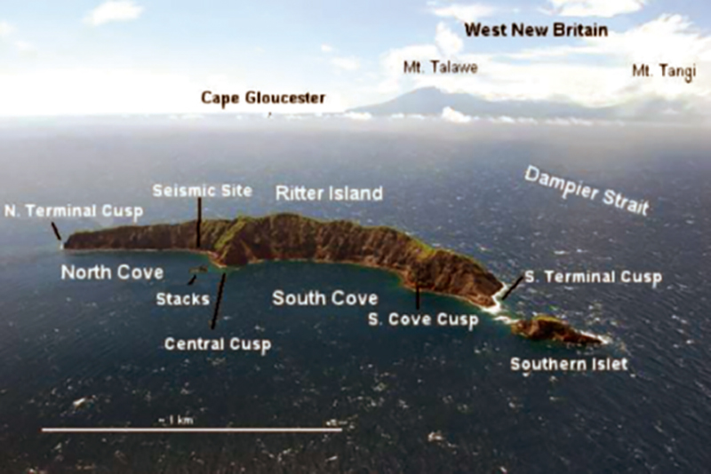 |
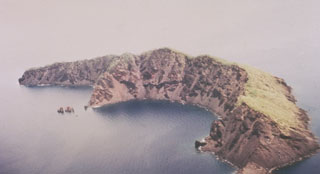
Figure 3. Oblique aerial view of Ritter Island photographed in 2006 by John Holder (the originator of Oceanic Expeditions) from SW looking NE, with some of the location names. From Saunders and Kuduon (2009). |
A Rabaul Volcanological Observatory (RVO) report by Saunder and Kuduon (2009) noted past possible geothermal activity on Ritter Island that had not been previously reported. According to their report, "In 1997 a patrol officer (Hita Mesere) in a media release relayed reports from Councilor Nalong (Kampalap Village?) of an explosive eruption and large waves reaching nearby villages. In the preparation of this report Mr. Mesere was contacted and he confirmed that he and officers from the Morobe PDO flew over Ritter after this event and saw white smoke coming from 'boiling' in the sea, close to land in the South Bay (Mesere, 2009 Pers. Comm.)."
The report concluded that "Ritter is active, both volcanically and geomorphologically. More volcanic activity can be expected. Seismically this will probably not be as intense as in the early 1970's, as the conduit seems now to be open. Volcanic phenomena may however increase in importance if the cone continues to grow towards the surface and magma is erupted into an environment of lower hydrostatic pressures. There seems to be two causes of eruptive activity, one is the rise of fresh magma at the site of the submarine cone and the other is slope instability causing water to come into contact with residual hot rocks leading to small hydrovolcanian events close inshore of Ritter."
The RVO report also included the following table (table 1) showing past observations of possible geothermal activity on Ritter Island.
Table 1. Dates and details of reported post-collapse activity at Ritter. From of Saunders and Kuduon (2009).
| Date | Seismic Intensity | Explosions reported | White steam reported | Dust/Dark material reported | Sound reported | Location of emission |
| 9 Oct. 1972 | Felt 35 km away; regionally recorded | Multiple | Y | Y | Strong rumbling | Inshore W (S Cove) & off terminal cusps |
| 17 Oct. 1974 | Felt 30 km away: recorded in PNG | Multiple | Y | Y | N | Offshore ~1 km W |
| 19 Oct. 1996? (Pilot report only) | None reported | N | Y | N | N | ? |
| 1997 | None reported | Single or few | Y | N | N | Inshore W (S Cove) |
| 17 Oct. 2006 | Few small, locally felt | N | Y | Y | N | Offshore ~1 km W |
| 19 May 2007 | None reported | Several | Y | Y (and flames) | Rumbling & 3 explosions | Offshore ~1 km W |
Tsunami of 1888. Several recent papers have revisited the 13 March 1888 collapse of Ritter Island volcano that generated a catastrophic tsunami. According to Ward and Day (2003), "In the early morning of 1888 March 13, roughly 5 km3 of Ritter Island Volcano fell violently into the sea northeast of New Guinea. This event, the largest lateral collapse of an island volcano to be recorded in historical time, flung devastating tsunami tens of meters high on to adjacent shores. Several hundred kilometers away, observers on New Guinea chronicled 3 min period waves up to 8 m high, that lasted for as long as 3 h. These accounts represent the best available first-hand information on tsunami generated by a major volcano lateral collapse." Eyewitness accounts noted the lack of explosive activity accompanying the collapse. In this paper, the authors simulated the Ritter Island landslide as constrained by a 1985 sonar survey of its debris field and compare predicted tsunami with historical observations.
Ray and others (2014) reported that, based on primary and secondary eyewitness accounts on the morning of 13 March 1888 "there is no clear evidence for a coincident [to the collapse] or causal magmatic explosive eruption. One report suggests that there was activity (perhaps phreatic or phreatomagmatic explosions?) prior to the collapse that lead some of the resident local communities to seek higher ground, but evidence for precursory flank movements or changes in eruptive style have not been found in the historical accounts."
References. Ray, M.J., Day, S., and Downes, H., 2014, The growth of Ritter Island volcano, Papua New Guinea, and the lateral collapse landslide and tsunami of 1888: new insights from eyewitness accounts, EGU General Assembly 2014, Geophysical Research Abstracts, v. 16, EGU2014-1305.
Saunders, S., and Kuduon, J., 2009, The June 2009 Investigation Of Ritter Volcano, With A Brief Discussion On Its Current Nature, Rabaul Volcanological Observatory Open File Report OFP 003/2009, 25 pp.
Ward, S.N., and Day, S. 2003. Ritter Island—lateral collapse and the tsunami of 1888. Geophysics Journal International, v. 154, pp. 891-902.
Geological Summary. Prior to 1888, Ritter Island was a steep-sided, nearly circular island about 780 m high between Umboi and Sakar Islands. Several historical explosive eruptions had been recorded prior to 1888, when large-scale slope failure destroyed the summit of the conical basaltic-andesitic volcano, leaving the arcuate 140-m-high island with a steep west-facing scarp. Devastating tsunamis were produced by the collapse and swept the coast of Papua New Guinea and offshore islands. Two minor post-collapse explosive eruptions, during 1972 and 1974, occurred offshore within the largely submarine 3.5 x 4.5 km breached depression formed by the collapse.
Information Contacts: Rabaul Volcanological Observatory, P.O. Box 386, Rabaul, Papua New Guinea.