Report on Cameroon (Cameroon) — March 2014
Bulletin of the Global Volcanism Network, vol. 39, no. 3 (March 2014)
Managing Editor: Richard Wunderman.
Cameroon (Cameroon) Brief 2012 explosion; follow up on earlier activity and studies
Please cite this report as:
Global Volcanism Program, 2014. Report on Cameroon (Cameroon) (Wunderman, R., ed.). Bulletin of the Global Volcanism Network, 39:3. Smithsonian Institution. https://doi.org/10.5479/si.GVP.BGVN201403-224010
Cameroon
Cameroon
4.203°N, 9.17°E; summit elev. 4095 m
All times are local (unless otherwise noted)
Introduction. The Associated Press reported a sudden explosion had occurred at Mount Cameroon on 3 February 2012 (see subsection below). A review of MODVOLC thermal alerts based on satellite infrared data during 2001 to mid-2014 found few if any of the highest-level alerts. In contrast, there were numerous stronger alerts during 3 March to 17 July 2000 (activity described in BGVN 24:09, 25:06).
In (BGVN 26:11) we reported that during 26-27 June 2001, Limbe, an economically important coastal town with ~85,000 residents located on the S foot of the steep sided stratovolcano Mt. Cameroon (figure 4), was struck by a series of heavy rains leading to deadly floods and landslides. Figure 5 shows a photo taken in Limbe during the flood. Although many would classify the flood as a meteorological disaster and not a volcanological one, Mt. Cameroon is the tallest peak in Western Africa and orogenic uplift of warm most air over the massive edifice is a factor affecting the amount of rainfall. Limbe sits at the mouth of drainages coming down this side of the edifice. During July 2014, heavy rains again resulted in floods in Limbe (Ndaley, 2014). In strict eruptive-hazard terms, Mount Cameroon is the only volcanic peak in Western Africa with recent ongoing eruptions.
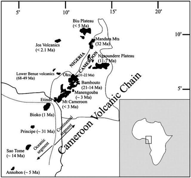 |
Figure 4. (Inset) Indicating the location of the Republic of Cameroon in Africa. (Main map) The location of Mount Cameroon, the main bulk of which is centered ~25 km from the coastline. Some other regional volcanic features and their ages are also indicated. Etinde is a prominent conical volcanic center on the SW flank of the larger structure of Mount Cameroon. The town of Limbe resides along the coast just S of the volcano. Taken from Suh and others (2008). |
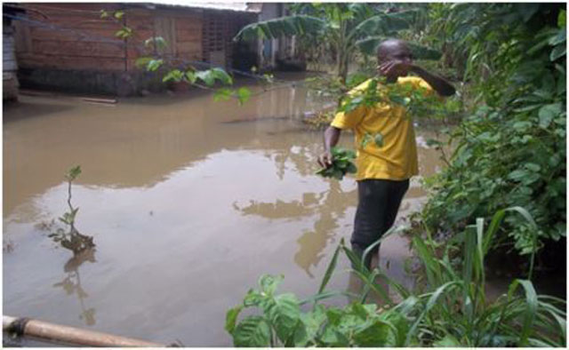 |
Figure 5. Flooding that inundated Clerks quarter, Limbe in 2001. The volcanic topography feeds a number of catchment basins into Limbe, which is also why the same town is also highly vulnerable to lava flows (Wantim and others, 2011). Photo taken from MIA-VITA literature. |
This report discusses recent research on the 2000 eruption of Mount Cameroon and then summarizes news articles on a smaller 2012 explosion. After that, this report discusses vulnerability studies, including a United Nations project that examined and attempted to mitigate the risk to local communities.
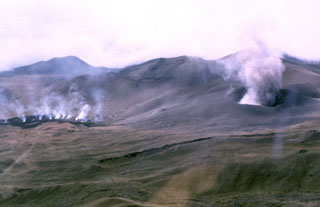
The 2000 eruption. On the basis of first-hand knowledge of some of their co-authors, Wantim and others (2011) stated that the eruption occurred during 28 May and 20 July 2000. MODVOLC satellite-based thermal alerts were found during the interval 3 March 2000 to 17 July 2000. The seismic activity for this eruption lasted 3 months, up to September 2000 (Ateba and others, 2009). Multiple fissure segments produced lava that built four different lava flow fields at three sites they specify in their paper (Wantim and others, 2011).
Eruptions at site 1 (~ 3,930 m a.s.l) began in the night of 28 May 2000 with an explosive phase that produced only tephra and ballistic blocks (Suh and others, 2003 and Wantim and others, 2011). A ~850 m-long ′a′a flow field was emplaced at this site a month later, an observation supported by data from MODVOLC and multispectral images (Landsat ETM + and ASTER) analyzed in this study. The upper 2000 flow is one of the shortest (850 m) recorded for historical lava flows here despite having descended steep slopes (10-25°). Late emission of the lava and field observations of cone breach at the lava source suggest that the lava flow was fed by the drainage of a transient lava lake. That lake was presumably formed by lava fountaining in the eruptive cone (Wantim and others., 2011). The lava flow field covers a total surface area of (8 ± 2) × 104 m2 with a total volume of (3.4 ± 0.8) × 105 m3. There were two lobes, ~4.5 m and ~8.7 m thick (Wantim and others., 2011).
Brief explosion--2012 news reports. Cameroon state radio and television reports stated that Mount Cameroon sent "ashes and flames" into the air in a brief explosion on 3 February 2012. A violent explosion lasted a couple of seconds and lightly injured two of the porters and guides on the mountain, according to a 6 February 2012 Associated Press report.
Lava flow hazard and risk, and weathering studies. According to Favalli and others (2010), Mt. Cameroon is one of the most active effusive volcanoes in Africa. About 500,000 people living or working around its fertile flanks are subject to significant threat from lava flow inundation. Therefore, this group initiated a scientific project to assess the hazards/risks associated with the volcano by simulating probable lava flow paths using the DOWNFLOW code, a routine that for lava-flow-hazard mapping that defines areas susceptible to inundation.
According to Wantim and others (2013), as for many other effusive volcanoes, only limited information exists on the relevant lava flow properties and emplacement dynamics for recent eruptions. This study provides new quantitative constraints for rheological and dynamic characteristics of lava flow effusion at Mount Cameroon during the 1982 and 2000 eruptions. These constraints were used to calibrate the FLOWGO thermo-rheological model for these lava flows. FLOWGO (Harris and Rowland, 2001) was the only model that enables full inversion of the thermo-rheological properties of lava flows. It can be constrained from channel morphology and down-flow evolution of crystal content.
Lava flow hazard and risk were assessed by simulating probable lava flow paths using the DOWNFLOW code (Tarquini and Favalli, 2011). That code incorporates digital elevation data and allows the definition of areas that are susceptible to inundation by lava flows originating from each vent; it has been used extensively to simulate lava flows at Mt. Etna and Nyiragongo volcanoes ( Favalli and others, 2005, 2006, 2009; Chirico and others 2009). The details of the modeling and the resulting maps they produced can be found in the cited references. Simulated lava flows from about 80,000 possible vents were used to produce a detailed lava flow hazard map. The lava flow risk in the area was mapped by combining the hazard map with digitized infrastructures (i.e., human settlements and roads).
Results show that the risk of lava flow inundation is greatest in the most inhabited coastal areas, specifically the town of Limbe (which constitutes the center of Cameroon's oil industry and an important commercial port). Buea, the second most important town in the area, has a much lower risk although it is significantly closer to the summit of the volcano. Non-negligible risk characterizes many villages and most roads in the area surrounding the volcano. In addition to the conventional risk mapping described above, the authors also present (1) two reversed risk maps (one for buildings and one for roads), where each point on the volcano is classified according to the total damage expected as a consequence of vent opening at that point; (2) maps of the lava catchments for the two main towns of Limbe and Buea, illustrating the expected damage upon venting at any point in the catchment basin. The hazard and risk maps provided here represent valuable tools for both medium/long-term land-use planning and real-time volcanic risk management and decision making.
The largely geochemical study of Che and others (2012), analyses the behavior and mobility of major and some trace elements during the physical and chemical development of landslide-prone soil profiles in Limbe, SW Cameroon. The soils result from in situ weathering of Tertiary basaltic and picrobasaltic rocks. Textural and chemical characterizations, together with two mass balance models are applied to understand the mobility and redistribution of elements during the weathering of pyroclastic cones and lava flows in the setting of Mt. Cameroon. This weathering is a major factor in the cohesion of steep slopes, and thus these studies address slope stability, another kind of volcano-related hazard that could occur even in times of volcanic quiescence.
Socio-economic vulnerability study. A United Nations project, MIA-VITA (Mitigate and Assess risk from Volcanic Impact on Terrain and human Activities) was started in Cameroon during 2011 (Apa and others, 2007; Bosi and others, 2011; European Commission, 2010). (The phrase 'Mia Vita' comes from the Italian, "My Life"). The project was based on the UN International Strategy for Disaster Reduction and a key expected outcome was to finding the best means to help local populations and authorities better perceive risks and thus reduce community vulnerability.
The program in Cameroon, as well in three other developing countries with active volcanoes, had several goals: (1) to assess the natural risk to local communities from the selected volcano, based on risk mapping and damage scenarios; (2) to improve crisis management, based on early warning systems and improved communications between government officials and the local populations, and (3) to reduce the vulnerability of populations in the wake of an eruption.
Besides Mount Cameroon, MIA-VITA also contributed to similar goals at Mount Merapi in Indonesia, Mount Kanlaon in Philippines, and Mount Fogo in Cape Verde. In the service of local citizens facing volcanic hazards, the MIA-VITA study also aimed to improve civil-defence, planning, and coordination and to reduce rumors and alarmist information.
MIA-VITA also integrates GIS capability with an analytic hierarchy method that yields volcanic risk maps. The approach is designed to solve complex multiple criteria problems using relative pairwise comparisons (Saaty, 1996; Wikipedia, 2014). To apply this approach, it is necessary to break down a complex unstructured problem into its component factors. The method incorporates both qualitative and quantitative criteria in the evaluation.
References. Apa, M.I., Kouokam, E:, Akoko, R.M, Thierry, P., and Buongiorno, M.F., 2007, Mt. Cameroon Socio-Economic Vulnerability and Resilience Assessment Through Traditional Survey Methods[FP7-ENV-2007-1] (URL: http://meetingorganizer.copernicus.org/EGU2011/EGU2011-3402.pdf http://meetingorganizer.copernicus.org/EGU2011/EGU2011-3402.pdf )
Bosi, V., Cristiani C. and Costantini, L., 2011, 3rd MIA-VITA Newsletter (Sept. 2011), MIA-VITA (URL: www.spinics.net/lists/volcano/msg02475.html )
Che, V.B., Fontijin, K., Ernst, G.G.J., Kervyn, M., Elburg, M, Van Ranst, E., Suh, C.E., 2012, Evaluating the degree of weathering in landslide-prone soils in the humid tropics: The case of Limbe, SW Cameroon; Geoderma, Vol. 170, pp. 378-389
Chirico G.D., Favalli, M., Papale, P., Pareschi, M.T., Boschi, E., 2009, Lava flow hazard at Nyiragongo volcano, D.R.C. 2. Hazard reduction in urban areas. Bull Volcanol 71:375-387. doi:10.1007/s00445-008-0232-z
European Commission, 2010 (31 March 2010), MIA-VITA--1st newsletter (URL: http://images.nationmaster.com/images/motw/africa/calabar_tpc_1996.jpg )
Favalli, M., Chirico, G.D., Papale, P., Pareschi, M.T., Boschi, E. (2009a) Lava flow hazard at Nyiragongo volcano, D.R.C. 1. Model calibration and hazard mapping. Bull Volcanol 71:363-374. doi:10.1007/s00445-008-0233-y
Favalli, M., Tarquini, S., Papale, P, Fomacai, A, and Boschi, E., 2011, Lava flow hazard and risk at Mt. Cameroon volcano, _Journal of Volcanology 2012 74:433-439. adsabs.harvard.edu/abs/2012BVol...74..423F
Favalli, M., Mazzarini, F., Pareschi, M.T., Boschi E (2009b) Topographic control on lava flow paths at Mount Etna, Italy: Implications for hazard assessment. J Geophys Res 114:F01019. doi:10.1029/2007JF000918
Favalli, M., Tarquini, S., Fornaciai, A., Boschi, E., 2009c, A new approach to risk assessment of lava flow at Mount Etna, Geology, 37(12):1111-1114. doi:10.1130/G30187A
Harris, AJL and Rowland, SK, 2001, FLOWGO: A kinematic thermorheological model for lava flowing in a channel. Bull Volcanol., . 63:20-44. doi:10.1007/s004450000120
Ndaley, Yannick Fonki, 2014, Heavy Rains Beat Limbe, Floods Put Residents In Distress. Eden Newspaper, 12 July 2014, (URL: http://edennewspaper.net/)
Saaty, T. L. (1996). Multicriteria decision making: The analytic hierarchy process. Pittsburgh, PA: RWS Publications, 479 pp. (ISBN 0962031712, 9780962031717)
Suh, C.E., Luhr, J.F., and Njome, M.S., 2008, Olivine-hosted glass inclusions from Scoriae erupted in 1954-2000 at Mount Cameroon volcano, West Africa, Journal of Volcanology and Geothermal Research, Volume 169, Issues 1-2, 1 January 2008, pp. 1-33, ISSN 0377-0273, http://dx.doi.org/10.1016/j.jvolgeores.2007.07.004.
Tarquini, S and Favalli, M, 2011, Mapping and DOWNFLOW simulation of recent lava flow fields at Mount Etna. Journal of Volcanology and Geothermal Research, 204:27-39. doi:10.1016/j.jvolgeores.2011.05.001
Wantim, M.N. , Kervyn, M., Ernst, G.G.J, del Marmol, M.A., Suh, C.E.. and Jacobs, P., 2013, Numerical experiments on the dynamics of channelised lava flows at Mount Cameroon volcano with the FLOWGO thermo-rheological model, Journal of Volcanology and Geothermal Research, Volume 253, pp. 35-53, ISSN 0377-0273
Wikipedia, 2014, Multi-criteria decision analysis (URL: http://en.wikipedia.org/wiki/Multi-criteria_decision_analysis ).
Geological Summary. Mount Cameroon, one of Africa's largest volcanoes, rises above the coast of west Cameroon. The massive steep-sided volcano of dominantly basaltic-to-trachybasaltic composition forms a volcanic horst constructed above a basement of Precambrian metamorphic rocks covered with Cretaceous to Quaternary sediments. More than 100 small cinder cones, often fissure-controlled parallel to the long axis of the 1400 km3 edifice, occur on the flanks and surrounding lowlands. A large satellitic peak, Etinde (also known as Little Cameroon), is located on the S flank near the coast. Historical activity was first observed in the 5th century BCE by the Carthaginian navigator Hannon. During historical time, moderate explosive and effusive eruptions have occurred from both summit and flank vents. A 1922 SW-flank eruption produced a lava flow that reached the Atlantic coast, and a lava flow from a 1999 south-flank eruption stopped only 200 m from the sea. Explosive activity from two vents on the upper SE flank was reported in May 2000.
Information Contacts: MODVOLC Thermal Alert System, Hawai'i Instiute of Geophysics and Planetology (HIGP), (Univ. of Hawai'i, 2525 Corrrea Road, Honolulu, HI 96822 USA (URL: http://modis.higp.hawaii.edu/); Mary-Ann del Marmol, Department of Geology and Soil Science, Ghent University, Krijgslaan 281 S8, 9000 Gent, Belgium; Associated Press, and Cameroon Radio Television, CRTV Siège, CRTV Mballa II B.P. 1634, Yaounde, Cameroon (URL: http://crtv.cm/).