Report on Gamkonora (Indonesia) — July 2014
Bulletin of the Global Volcanism Network, vol. 39, no. 7 (July 2014)
Managing Editor: GVP Staff.
Gamkonora (Indonesia) Phreatic eruption in January 2013 followed by elevated seismicity
Please cite this report as:
Global Volcanism Program, 2014. Report on Gamkonora (Indonesia) (GVP Staff, ed.). Bulletin of the Global Volcanism Network, 39:7. Smithsonian Institution. https://doi.org/10.5479/si.GVP.BGVN201407-268040
Gamkonora
Indonesia
1.38°N, 127.53°E; summit elev. 1635 m
All times are local (unless otherwise noted)
Tremor and emissions had been reported by the Pusat Vulkanologi dan Mitigasi Bencana Geologi (PVMBG) during mid-2011 through mid-2012 (BGVN 37:04). An eruption described by PVMBG and the UN's Humanitarian Early Warning Service (HWS), a service of the Inter-Agency Standing Committee (IASC), took place on 23 January 2013. PVMBG reported that it was a phreatic eruption on preceded by increased seismicity. Specifically, an increase in volcanic earthquakes (VA), followed by an increase in shallow volcanic earthquake (VB) and "tornillo-type" earthquakes.
During March-April 2013, seismic signals increased. Towards the end of March the number of VA earthquakes increased followed by an increase in VB earthquakes in late April. Harmonic tremor increased in early May. On 24 May seismicity indicative of shallow magma movement increased and diffuse white plumes reached 100-300 above the crater. On 25 May a gas plume rose from the crater. During 25-27 May denser white-to-gray plumes rose 200-500 m above the crater rim. On 27 May the Alert Level was raised to 3; residents and tourists were asked not to venture near the crater within a radius of 3 km.
PVMBG reported that the Gamsungi post observers noted diffuse white plumes rising 300 m above the crater rim during 27 May-30 June 2013. Seismicity declined overall, but a seismic crisis characterized by continuous tremor occurred on 10 June; tremor was absent during 13-30 June. The Alert Level was lowered to 2 (on a scale of 1-4) on 1 July; residents and tourists were asked not to venture near the crater within a radius of 1.5 km.
Petrology of 2007 eruptive products. The 2007 eruption was andesitic in nature. The event occurred after 20 years of dormancy and prompted the evacuation of 8,000 residents living near the volcano. PVMBG scientists examining the eruption also posted deformation, petrologic, and other data. Chemical analysis showed that samples from lava tops, a lava peak, a lava dome, a pyroclastic flow, and a bomb were all andesite, with SiO2 values between 53.62 and 56.91% (by weight).
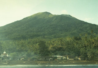
Geological Summary. The shifting of eruption centers on Gamkonora, the highest peak of Halmahera, has produced an elongated series of summit craters along a N-S trending rift. Youthful-looking lava flows originate near the cones of Gunung Alon and Popolojo, south of Gamkonora. Since its first recorded eruption in the 16th century, typical activity has been small-to-moderate explosive eruptions. Its largest recorded eruption, in 1673, was accompanied by tsunamis that inundated villages.
Information Contacts: Center of Volcanology and Geological Hazard Mitigation (PVMBG), Jalan Diponegoro 57, Bandung 40122, Indonesia (URL: http://www.vsi.esdm.go.id/); Darwin Volcanic Ash Advisory Centre (VAAC), Bureau of Meteorology, Northern Territory Regional Office, PO Box 40050, Casuarina, NT 0811, Australia (URL: http://www.bom.gov.au/info/vaac/); Humanitarian Early Warning Service (HEWS), a Service of the Inter-Agency Standing Committee (IASC) (URL: http://www.hewsweb.org/).