Report on Nevado del Ruiz (Colombia) — July 2014

Bulletin of the Global Volcanism Network, vol. 39, no. 7 (July 2014)
Managing Editor: Richard Wunderman.
Edited by Julie A. Herrick.
Nevado del Ruiz (Colombia) Frequent ash plumes during September 2012-July 2013; continuing gas emissions
Please cite this report as:
Global Volcanism Program, 2014. Report on Nevado del Ruiz (Colombia) (Herrick, J.A., and Wunderman, R., eds.). Bulletin of the Global Volcanism Network, 39:7. Smithsonian Institution. https://doi.org/10.5479/si.GVP.BGVN201407-351020
Nevado del Ruiz
Colombia
4.892°N, 75.324°W; summit elev. 5279 m
All times are local (unless otherwise noted)
During September 2012-July 2014 the Servicio Geológico Colombiano (SGC) maintained Alert Level Yellow at Nevado del Ruiz due to elevated SO2 flux, seismicity, and intermittent ash emissions; the Alert Level had been lowered to Yellow on 5 September. No major geophysical changes were noted during this time period.
Gas plumes were frequently visible rising as high as 3,500 m above the summit (figure 67). Minor gas-and-ash plumes occasionally occurred throughout this reporting period, and were often associated with episodes of tremor. Ashfall was reported from areas around the volcano (figure 68), notably on 11 July 2013 when ash reached Manizales (~30 km NW). The Washington Volcanic Ash Advisory Center (VAAC) reported ash plumes visible in satellite images on 10 October 2012 (reaching ~7 km altitude) and 11 July 2013 (reaching ~6 km altitude). A possible ash plume was detected at ~7.6 km altitude on 16 June 2013.
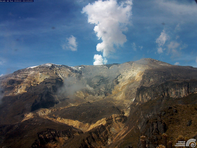 |
Figure 67. White gas plumes frequently rise 750-3,500 m above the Nevado del Ruiz crater rim, as seen in this webcamera image taken at 0648 on 3 April 2014. The camera location is ~6 km NE of Arenas crater (Piraña station). Courtesy of SGC. |
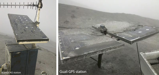 |
Figure 68. Persistent ashfall challenged the local monitoring systems for Nevado del Ruiz in September 2012. These two stations, a ScanDOAS station Bruma/Azufrado (left) and the GPS station at Gualí (right), were the focus of fieldwork by SGC staff in September. Courtesy of SGC. |
SGC reported continuous and elevated SO2 emissions during this reporting period. Gas monitoring included satellite images, field installations (ScanDOAS), and MobileDOAS. ScanDOAS values captured the dramatic increase in SO2 flux during the explosive eruptions of early 2012 (BGVN 37:08). Since September 2012, the maximum daily average frequently exceeded 6,000 tons per day and exceeded 9,500 tons/day three times: twice in June 2013 and once in July 2014. MobileDOAS measurements were collected by the SGC during field campaigns and the values are reported in monthly technical bulletins available online (in Spanish).
Seismicity. Volcano-tectonic earthquakes (VT), long-period earthquakes (LP), and tremor were detected by the monitoring network throughout this reporting period. Earthquakes were detected from the summit glaciers, as well, notably in February 2014. Increased VT seismicity was notable during October 2012 (figure 69), 23-24 February 2013, 13 April-4 May 2013, 5-10 October 2013, 18-27 June 2014, and 29 July 2014 (figure 70). Maximum local magnitudes of VT earthquakes in the range of 1.6-4.4 were detected during this time period at depths of 0.5-13 km.
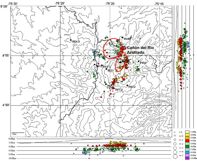 |
Figure 69. Seismicity from Nevado del Ruiz during October 2012 was elevated; 2,179 VT earthquakes were located. Two main areas of concentration were located N and NE of the summit (circled in red). Black squares are seismic stations; color coding refers to depth; circle size correlates with earthquake magnitudes. Courtesy of SGC. |
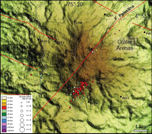 |
Figure 70. Elevated seismicity from Nevado del Ruiz on 29 July 2014 consisted of 746 VT earthquakes detected in a zone ~2 km long SSW of the main crater, Arenas. Red lines correspond to local faults as well as Palestina, the regional, cross-cutting fault trending NE-SW. Depths of earthquakes are correlated to colors in the key as well as magnitudes based on circle size. Courtesy of SGC. |
Geological Summary. Nevado del Ruiz is a broad, glacier-covered volcano in central Colombia that covers more than 200 km2. Three major edifices, composed of andesitic and dacitic lavas and andesitic pyroclastics, have been constructed since the beginning of the Pleistocene. The modern cone consists of a broad cluster of lava domes built within the caldera of an older edifice. The 1-km-wide, 240-m-deep Arenas crater occupies the summit. The prominent La Olleta pyroclastic cone located on the SW flank may also have been active in historical time. Steep headwalls of massive landslides cut the flanks. Melting of its summit icecap during historical eruptions, which date back to the 16th century, has resulted in devastating lahars, including one in 1985 that was South America's deadliest eruption.
Information Contacts: Servicio Geológico Colombiano (SGC), Volcanological and Seismological Observatory, Avenida 12 Octubre 15-47, Manizales, Colombia (URL: https://www2.sgc.gov.co/volcanes/index.html); Washington Volcanic Ash Advisory Center (VAAC), Satellite Analysis Branch (SAB), NOAA/NESDIS E/SP23, NOAA Science Center Room 401, 5200 Auth Rd, Camp Springs, MD 20746, USA (URL: http://www.ospo.noaa.gov/Products/atmosphere/vaac/).