Report on Cleveland (United States) — August 2014
Bulletin of the Global Volcanism Network, vol. 39, no. 8 (August 2014)
Managing Editor: GVP Staff.
Cleveland (United States) Multiple explosions and minor ash plumes continue into early June 2014
Please cite this report as:
Global Volcanism Program, 2014. Report on Cleveland (United States) (GVP Staff, ed.). Bulletin of the Global Volcanism Network, 39:8. Smithsonian Institution. https://doi.org/10.5479/si.GVP.BGVN201408-311240
Cleveland
United States
52.825°N, 169.944°W; summit elev. 1730 m
All times are local (unless otherwise noted)
Cleveland experienced frequent minor ash emissions during January 2012-September 2013. During that reporting period activity was monitored by the seismic network on nearby Umnak Island (140 km NE) or through satellite imagery because there was no ground-based seismic instrumentation. In April 2012 and May 2013, explosion-generated ash plumes reached more than 4 km above the summit crater (BVGN 38:10). Some energetic eruptions were also accompanied by dome destruction and hot lahars that descended the flanks.
During October 2013-September 2014, the time period covered in this report, activity included short-duration explosions recorded by the Alaska Volcano Observatory's (AVO) infrasound or pressure sensors and the seismic network, and weakly elevated surface temperatures and plumes recorded by satellite imagery (table 7 and figure 16). The volcano Alert Level was raised to Watch (Aviation Color Code raised to Orange) during 2-9 January 2014 as a result of explosions creating minor ash plumes, but returned to Advisory (Yellow) on 10 January.
Table 7. Notable observations of Cleveland based on infrasound sensors and satellite imagery during October 2013-September 2014. Courtesy of AVO.
| Date | Time | Infrasound sensors | Satellite imagery |
| 02 Oct 2013 | 0424 | Short duration explosion. | -- |
| 05 Oct 2013 | -- | Continuous pressure waves; discrete small explosions. | -- |
| 13 Nov 2013 | -- | -- | Weakly elevated surface temperatures near summit. |
| 25 Nov 2013 | 1931 | Small, short duration explosion. | -- |
| 28 Dec 2013 | 1229 | Brief explosion. | Elevated temperatures. |
| 30 Dec 2013 | 1906 | Brief explosion. | Minor ash plumes detached from summit. |
| 01 Jan 2014 | 1900 | Explosion. | Minor ash plumes detached from summit. |
| 02 Feb 2014 | -- | -- | Weak elevated surface temperatures. |
| 17, 19, 20 Feb 2014 | -- | -- | Steam plume. |
| 24 Feb 2014 | 1917 | Explosion. | Small ash clouds; 5 km altitude. |
| 25 Feb 2014 | 0135 | Explosion. | Small ash clouds; 5 km altitude. |
| 05 Jun 2014 | 1008 | Explosion. | Small detached ash plume. |
| 06 Jun 2014 | 0004 | -- | Small, detached cloud with a weak ash signal. |
| 07 Jul 2014 | -- | -- | Weakly elevated surface temperatures. |
| 08-09 Jul 2014 | -- | -- | Vigorous steam and gas plume. |
| 20, 21, 26-31 Jul 2014 | -- | -- | Elevated surface temperature in summit crater. |
| 18 Aug 2014 | -- | -- | Elevated surface temperature. |
| 01-05 Sep 2014 | -- | -- | Thermal feature at summit. |
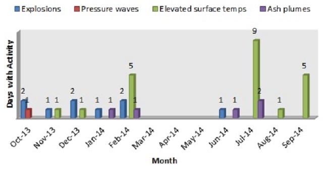 |
Figure 16. Graphical summary of activity at Cleveland, showing the days with observed activity during October 2013-Septamber 2014. Courtesy of AVO. |
Activity during October-December 2013. A small explosion was detected by infrasound sensors on 2 October 2013. The following two days, three total explosions were recorded. On 5 October continuous pressure waves likely due to gas jetting and discrete small explosions were recorded by infrasound sensors on Okmok, located on Umnak Island.
From October through the first three weeks of December, evidence of further ash emissions was absent from satellite imagery. After the two explosions on 28 and 30 December 2013, AVO stated ash clouds may have been generated but were not detected in satellite data.
Activity during January-March 2014. By 2 January 2014, AVO observed that Cleveland seemed to have entered a "renewed phase of elevated unrest." Ash plumes visible in satellite images extended 75-100 km N of the volcano. Subsequent analysis of the images concluded the plumes rose no more than 4.6 km altitude.
Following explosions in late February 2014, satellite observations showed deposits of ash and large lava blocks on the upper flank, 2.5 km from the summit. This indicated the February explosions were more energetic than those commonly observed over the past few years.
In the evening of 6 March, residents of Nikolski (located on Umnak Island) reported small bursts of ash rising less than 300 m above the summit. These small, brief, events were not detected by satellite imagery or by AVO seismic and infrasound networks.
Activity during June-September 2014. After two months of relative quiet, an explosion on 5 June was recorded by the Dillingham acoustic infrasound array and seismic stations at Korovin volcano, 288 km W. The event was reported to be short in duration and had a similar amplitude to explosions in past years. A detached cloud observed on 6 June had an altitude of 7.6 km, traveled 140 km SW, and subsequently dissipated.
During the week of 8 August 2014, scientists working near Cleveland observed steady gas-and-steam plumes emitted from the summit crater, and incandescence at the summit. According to AVO, on 15 August scientists reported "puffing activity consisting of steam and gas from the summit and vapor clouds over the volcano."
In mid-August, the National Science Foundation sent researchers to install two monitoring stations, powered by batteries and solar power, on Chugunadak Island 15 km from Cleveland's summit. This was the first time modern geological equipment had been placed in such close proximity to Mount Cleveland due to its remote location. Station CLES (Cleveland East) at the SE base of Cleveland hosts both broadband and short-period seismometers, along with two infrasound sensors. On the SE coast of Chuginadak (figure 17) station CLCO (Concord Point) consists of short-period seismometers, a web-camera, and an array of five infrasound sensors. The monitoring stations will provide real-time observations to scientists who have previously been relying solely on distant seismic networks and satellite data.
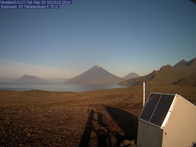 |
Figure 17. View of Cleveland on 20 September 2014 taken from the newly installed web camera located near Concord Point, Chuginadak Island. It looks WNW to Cleveland. Mount Herbert is visible on the far left, along with Mount Carlisle on the right. The camera turns on once an hour to capture three images. Courtesy of AVO. |
On the evening of 17 August, a steam plume was visible from the web camera at Station CLES, followed by another small steam plume the morning of 29 August.
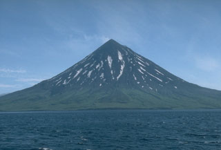
Geological Summary. The beautifully symmetrical Mount Cleveland stratovolcano is situated at the western end of the uninhabited Chuginadak Island. It lies SE across Carlisle Pass strait from Carlisle volcano and NE across Chuginadak Pass strait from Herbert volcano. Joined to the rest of Chuginadak Island by a low isthmus, Cleveland is the highest of the Islands of the Four Mountains group and is one of the most active of the Aleutian Islands. The native name, Chuginadak, refers to the Aleut goddess of fire, who was thought to reside on the volcano. Numerous large lava flows descend the steep-sided flanks. It is possible that some 18th-to-19th century eruptions attributed to Carlisle should be ascribed to Cleveland (Miller et al., 1998). In 1944 it produced the only known fatality from an Aleutian eruption. Recent eruptions have been characterized by short-lived explosive ash emissions, at times accompanied by lava fountaining and lava flows down the flanks.
Information Contacts: Alaska Volcano Observatory (AVO), a cooperative program of a) U.S. Geological Survey, 4200 University Drive, Anchorage, AK 99508-4667, USA (URL: http://www.avo.alaska.edu/), b) Geophysical Institute, University of Alaska, PO Box 757320, Fairbanks, AK 99775-7320, USA (URL: http://www.gi.alaska.edu/), and c) Alaska Division of Geological & Geophysical Surveys, 794 University Ave., Suite 200, Fairbanks, AK 99709, USA (URL: http://www.dggs.alaska.gov/)