Report on Shishaldin (United States) — January 2015
Bulletin of the Global Volcanism Network, vol. 40, no. 1 (January 2015)
Managing Editor: Richard Wunderman.
Shishaldin (United States) Start of a low-level eruption in January 2014
Please cite this report as:
Global Volcanism Program, 2015. Report on Shishaldin (United States) (Wunderman, R., ed.). Bulletin of the Global Volcanism Network, 40:1. Smithsonian Institution. https://doi.org/10.5479/si.GVP.BGVN201501-311360
Shishaldin
United States
54.756°N, 163.97°W; summit elev. 2857 m
All times are local (unless otherwise noted)
Shishaldin, located on Unimak Island, is one of the most active volcanoes within the Aleutian Islands (figure 6). [Our last Bulletin report (BGVN 33:08) discussed activity at Shishaldin in February 2008, when a pilot reported a 3 km altitude ash plume. This report summarizes activity] from January to December 2009 and from January 2014 to March 2015. During 2009, Shishaldin emitted steam plumes, generated thermal anomalies, and underwent several episodes of tremor[; information for 2009 drew heavily on McGimsey and others (2014)]. From 2014 through March 2015, Shishaldin experienced elevated surface temperatures, steam emissions, and starting in March 2014, an ongoing low-level lava eruption within the summit crater that occasionally deposited ash on the upper flanks. As of March 2015, this low-level eruption continued. Considerable information in this report was found in material released by the Alaska Volcano Observatory (AVO).
 |
Figure 6. Map showing the location of Shishaldin. The volcano is located near the center of Unimak Island, and is the tallest peak and one of the most active volcanoes within the Aleutians Islands. False Pass, located 38 km to the NE, is the closest town. Map is courtesy of Alaska Volcano Observatory and Alaska Division of Geological & Geophysical Surveys. |
Activity during January-December 2009. According to AVO, activity began on 5 January (± 1 month) and ended on 16 August, and was characterized as a questionable eruption. According to McGimsey and others (2014), increased seismicity, small steam plumes as well as thermal anomalies characterized activity during 2009. Steam plumes are considered normal at Shishaldin according to McGimsey and others (2014).
McGimsey and others (2014), stated that there was an increase in observed thermal anomalies at Shishaldin in early January 2009. On 5-6 January, an AVHRR satellite image of Unimak Island showed a thermal anomaly centered on Shishaldin's summit crater. The anomaly reached a 2-pixel size on 6 January. There was also a slight increase in seismicity. These observations indicated a clear departure from background conditions. On 6 January, AVO increased Shishaldin's Aviation Color Code (ACC) from Green to Yellow and the Volcano Alert Level from Normal to Advisory. That day, pilots and ground observers reported a constant steam plume rising ~300 m above the summit and drifting 16-25 km SE (McGimsey and others, 2014).
Over the next few days, AVO continued observing a thermal anomaly in satellite images. On 7 January 2009, AVO received both a pilot report and observations from Cold Bay (93 km to the NE, figure 6) noting a vigorous steam plume rising from Shishaldin. On 8 January, satellite images showed a steam-filled crater with no ash on the flanks (McGimsey and others, 2014). AVO's 9 January 2009 Weekly Update stated "Although detection of a thermal anomaly is rare at this volcano, it is not certain that this unrest will lead to an eruption. A thermal anomaly was observed in the months leading up to the last significant eruption at Shishaldin [that occurred] in 1999; this fact, combined with the likelihood that an eruption at Shishaldin could occur with little or no seismic precursors, drove AVO's decision to raise the Color Code and Alert Level."
On 11 January 2009, a photo captured by a pilot showed pulsing steam plumes. Two days later, AVO seismologists identified a minor, low-amplitude tremor that persisted for a few weeks. According to McGimsey and others (2014), during the next few weeks, seismicity remained low, a few thermal anomalies were detected, and steaming was observed.
According to AVO's 13 February 2009 Weekly Update, a very weak thermal anomaly was detected on 3 February. The Update went onto say that on 11 February, the ACC was downgraded to Green and the Volcano Alert Level lowered to Normal, due to Shishaldin's return to background conditions. That Update also mentioned that seismic activity had remained low, since decreasing to background levels in late December 2008.
McGimsey and others (2014) reported that over the next seven weeks (mid-February to early April 2009) occasional thermal anomalies were observed along with continuous low-level tremor, which was not considered unusual. On 7 April, a pilot reported that he saw Shishaldin steaming more vigorously than he had previously observed during his weekly flights past Shishaldin over the last 16 months. That day, a thermal anomaly was also observed in satellite imagery (McGimsey and others, 2014).
On 20 April 2009, thermal activity at Shishaldin's summit spiked based on multiple thermal anomalies containing saturated pixels observed in satellite imagery (McGimsey and others, 2014). According to McGimsey and others (2014), these anomalies indicated high ground temperatures (greater than 300°C). This level of thermal activity was last seen before Shishaldin's eruption in 1999. On 5 May, a pilot reported steaming from Shishaldin and a passenger on a different flight reported dark-colored linear features on the N side of the summit. According to McGimsey and others (2014), these linear features were later interpreted as minor streams of dirty water trailing downslope.
McGimsey and others (2014) reported that throughout June 2009, thermal anomalies were detected on about one third of days, with a particularly strong anomaly being recorded on 9 June. No unusual seismic activity was noted. On the night of 25 June, an ASTER thermal infrared satellite image captured a thermal anomaly and a 22 km-long steam plume extending E-NE from Shishaldin. Then on 29 June, an observer in Cold Bay (93 km NE) reported increased steaming at Shishaldin over the past few days.
In the first week of July 2009, thermal anomalies at Shishaldin increased in intensity, with a return of saturated pixels, indicating high ground temperatures. On 10 July, AVO increased the ACC from Green to Yellow and the Volcano Alert Level from Normal to Advisory, due to the increase and continued presence of thermal anomalies. Seismicity and deformation did not change significantly during this time and satellite data did not show any noteworthy SO2 emissions. On 13 July, emissions were detected in satellite imagery and a pilot reported a steam plume rising 600 m above Shishaldin and moving NW. On 15 July, the satellite-based Ozone Monitoring Instrument (OMI) detected a small cloud rich in SO2 that originated from Shishaldin. For the rest of July and the first half of August 2009, steaming was observed from Shishaldin's summit, when weather permitted. Thermal anomalies were also detected in satellite images during August; one example was on 16 August.
In mid-September 2009, pressure sensors at Shishaldin detected anomalous airwaves. According to McGimsey and others (2014), the airwaves could be indicative of minor explosions; however, in retrospective analysis of the data collected by the pressure sensors, the airwaves were found to be a common occurrence and linked to episodic gas bursts (examples of which were seen during 2003-2004). On 19 October 2009, due to the continued absence of thermal anomalies, a decrease in steam emissions and seismicity considered within background levels, AVO lowered the ACC to Green and the Volcano Alert Level to Normal. Besides a weak thermal anomaly detected on 2 November, Shishaldin remained quiet for the remainder of 2009.
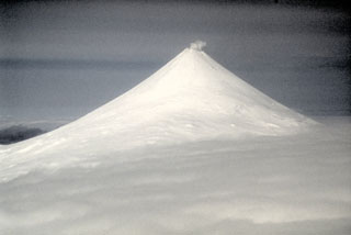
Non-eruptive interval during 2010-2013. AVO reported no unusual activity at Shishaldin between the years 2010 and 2013. In 2010, 2012 and 2013, AVO uploaded photos of Shishaldin, some of which showed the volcano emitting steam (figure 7).
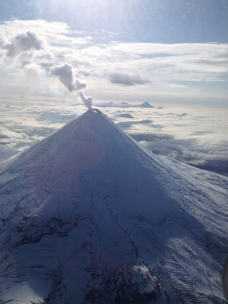 |
Figure 7. Photograph of Shishaldin emitting a steam plume on 14 September 2013. The photograph was taken from Korpiewski (2013). |
Activity during January 2014-March 2015. [AVO reported increased activity] on 28 January 2014 at Shishaldin. A low-level lava eruption within the summit crater then began in March 2014 and continued through March 2015. In addition to the ongoing eruption, there were also instances of heightened activity, one such example occurring around 28 October 2014, after AVO noted several days of elevated tremor and stronger thermal anomalies. AVO provides a description that synthesizes Shishaldin activity from late January 2014 through March 2015 on their website (as accessed on 1 May 2015). What follows is a quote of that description. For greater detail on activity during this interval, please see AVO's Weekly and Daily reports. Any information added to the quote by Bulletin editors has been [bracketed]. Bulletin editors also included pictures, depicting certain events that were described in the quote.
"On January 30, 2014, the Alaska Volcano Observatory raised the Volcano Alert Level to ADVISORY and the Aviation Color Code to YELLOW for Shishaldin, based on satellite observations of the previous days [figure 8]. Satellite observations included increased surface temperatures in the summit crater, as well as increased emissions of steam. Similar levels of unrest were last observed during 2009, and did not result in an eruption.
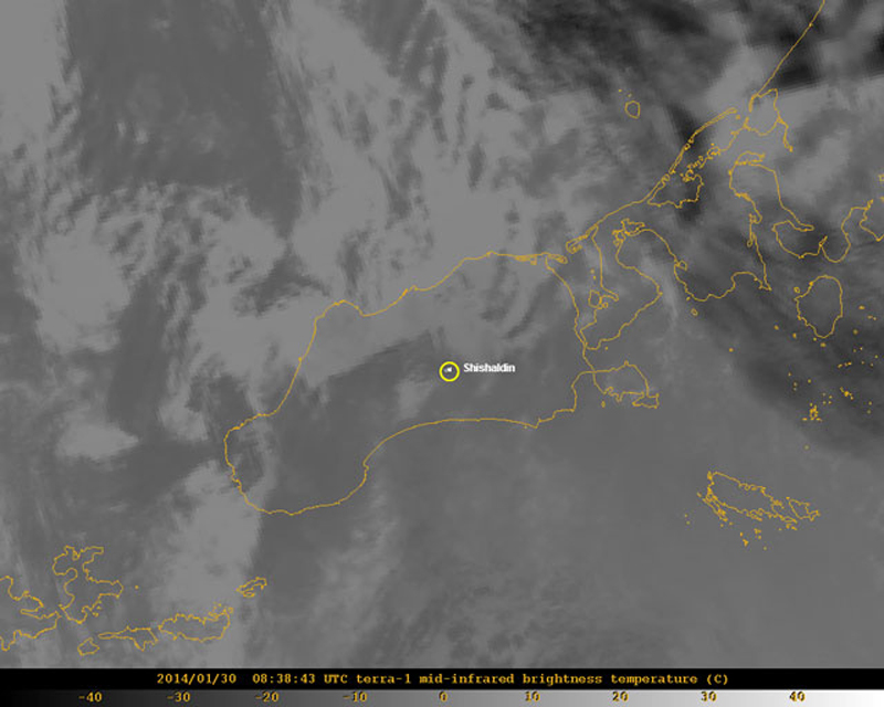 |
Figure 8. Satellite image of Shishaldin on Unimak Island captured at 0838 UTC on 30 January 2014. The image shows the elevated surface temperatures in the summit crater of Shishaldin. According to the AVO caption for this image, "This mid-infrared image is scaled so that warm values are bright white and cold values (like high clouds are dark). The elevated surface temperatures are visible as the white pixels within the yellow circle that indicates the location of Shishaldin." Image was created by Dave Schneider and is courtesy of Alaska Volcano Observatory/ U.S. Geological Survey. |
"For the next week, persistent elevated surface temperatures were visible in satellite imagery of the summit crater during clear-weather intervals. On February 7, a possible volcanic cloud was observed in satellite images beginning around 1545 UTC (6:45 AKST). This cloud may have resulted from a small explosive event at the volcano. The event was small enough that it was not detected by the one working seismic station near the volcano, but it appears to coincide with a signal recorded by a nearby tiltmeter. Satellite images suggest that the cloud may have reached as high as [7.6 km above sea level], was ash-poor, and short-lived. There was no evidence of elevated surface temperatures observed in satellite data immediately following this event, suggesting it was primarily a gas event and very little to no hot material was produced or deposited on the flanks of the volcano.
"On March 19, elevated surface temperatures were again detected in satellite data, accompanied by ground-coupled airwaves seen in the seismic data. On March 28, after seeing persistent elevated surface temperatures since March 19, and continuing ground-couple airwaves, AVO data analysis showed temperatures in satellite images consistent with the eruption of lava within the summit crater. [The 28 March 2014 Volcanic Activity Notification (VAN) stated, 'The current activity appears to be confined to the deep summit crater and there have been no observations of lava on the flanks of the volcano or surrounding the summit crater.']
"During the week of April 11, minor ash deposits extending several hundreds of meters from the summit crater were observed in satellite imagery. Infrasound signals from Shishaldin were occasionally detected at sensors located at Dillingham [585 km to the NE] and Akutan Island [145 km to the SW].
"Throughout April, May, June, and July, elevated surface temperatures consistent with low-level eruptive activity in the summit crater were observed in satellite data, and small explosion signals were detected in seismic data. Occasional clear webcam views often showed minor steaming. An AVO overflight on August 10 showed hot, glowing material in the crater [figure 9]. On August 13, AVO received a pilot report of a low-level plume. [On 23 August, a pilot reported a steam-and-ash plume rose ~300 m above the summit and drifted NE.] Similar levels of activity continued throughout August, September, and October.
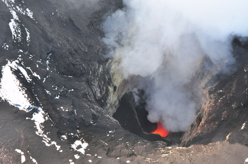 |
Figure 9. Photograph of incandescent material within Shishaldin's steaming summit crater and steam being emitted. This aerial photograph was captured on 10 August 2014 and shows ash deposited on the snow (in the left of the photo). Photo was captured by Cyrus Read and is courtesy Alaska Volcano Observatory/ U.S. Geological Survey. |
"On October 28, 2014, AVO noted an increase in intensity over the past several days, including elevated seismic tremor and stronger thermal anomalies. New deposits of ash and ballistics darkened the summit area, and the activity was also recorded on infrasound stations at Akutan and Dillingham. [On 26 October, clear webcam images revealed tephra deposits at the summit. The 28 October 2014 VAN stated that these new deposits indicated, '…the activity was energetic enough to eject material from a depth of several hundred meters (~600 ft) within the summit crater.'] This period of increased tremor lasted for several further days.
"On November 24, seismic activity at Shishaldin again increased.... This increased seismicity declined by November 27, but remained above background. [AVO's 28 November 2014 Weekly Update said, 'Although the level of seismic activity has declined during the week, it is likely that a low-level lava eruption is ongoing within the summit crater of the volcano.'] Weak, but above background seismicity, along with weakly elevated crater surface temperatures, continued in December 2014 and January 2015.
"In late January 2015, strongly elevated temperatures were observed in satellite images, consistent with active lava within the crater. [AVO's 23 January 2015 Weekly Update stated, 'Activity [over the past week was] consistent with what we have observed at Shishaldin during the past several months, which includes lava effusion in the crater with occasional production of small amounts of ash restricted to the volcano's upper flanks.'] A wispy, low-level ash emission was observed in webcam images on February 2, 2015.
"Throughout February and March 2015, clear satellite views often show elevated surface temperatures at the crater, seismicity remained above background, and low-level steam emissions were frequently seen in webcam images. It is likely that low-level eruptive activity continued within the summit crater."
References.
Alaska Volcano Observatory (AVO), Shishaldin reported activity, URL: https://www.avo.alaska.edu/volcanoes/volcact.php?volcname=Shishaldin, date accessed: 1 May 2015
Alaska Volcano Observatory (AVO), Shishaldin reported activity, Event specific information [for 2009], URL: https://www.avo.alaska.edu/volcanoes/activity.php?volcname=Shishaldin&page=basic&eruptionid=76, date accessed: 1 May 2015
Alaska Volcano Observatory (AVO), Shishaldin reported activity, Event specific information [for 2014], URL: https://www.avo.alaska.edu/volcanoes/activity.php?volcname=Shishaldin&page=basic&eruptionid=77, date accessed: 1 May 2015
Alaska Volcano Observatory/Alaska Division of Geological & Geophysical Surveys, 2009, URL: http://www.avo.alaska.edu/images/image.php?id=16190, date accessed: 1 May 2015
Korpiewski, J., U.S. Coast Guard, 2013, URL: http://www.avo.alaska.edu/images/image.php?id=57087, date accessed: 13 May 2015
McGimsey, R.G., Neal, C.A., Girina, O.A., Chibisova, Marina, and Rybin, Alexander, 2014, 2009 Volcanic activity in Alaska, Kamchatka, and the Kurile Islands - summary of events and response of the Alaska Volcano Observatory: U.S. Geological Survey Scientific Investigations Report 2013-5213, 125 p., URL: http://pubs.usgs.gov/sir/2013/5213/
Read, C., Alaska Volcano Observatory/U.S. Geological Survey, 2014, URL: http://www.avo.alaska.edu/images/image.php?id=66771, date accessed: 13 May 2015
Schneider, D., Alaska Volcano Observatory/U.S. Geological Survey, 2014, URL: http://www.avo.alaska.edu/images/image.php?id=57691, date accessed: 13 May 2015.
Geological Summary. The symmetrical glacier-covered Shishaldin in the Aleutian Islands is the westernmost of three large stratovolcanoes in the eastern half of Unimak Island. The Aleuts named the volcano Sisquk, meaning "mountain which points the way when I am lost." Constructed atop an older glacially dissected edifice, it is largely basaltic in composition. Remnants of an older edifice are exposed on the W and NE sides at 1,500-1,800 m elevation. There are over two dozen pyroclastic cones on its NW flank, which is covered by massive aa lava flows. Frequent explosive activity, primarily consisting of Strombolian ash eruptions from the small summit crater, but sometimes producing lava flows, has been recorded since the 18th century. A steam plume often rises from the summit crater.
Information Contacts: Alaska Volcano Observatory (AVO), a cooperative program of the U.S. Geological Survey, 4200 University Drive, Anchorage, AK 99508-4667, USA (URL: http://www.avo.alaska.edu/), the Geophysical Institute, University of Alaska, PO Box 757320, Fairbanks, AK 99775-7320, USA, and the Alaska Division of Geological and Geophysical Surveys, 794 University Ave., Suite 200, Fairbanks, AK 99709, USA; Anchorage Volcanic Ash Advisory Center (VAAC), Alaska Aviation Weather Unit, and NWS NOAA US Dept of Commerce, 6930 Sand Lake Road, Anchorage, AK 99502-1845, USA (URL: http://vaac.arh.noaa.gov/).