Report on San Miguel (El Salvador) — August 2015
Bulletin of the Global Volcanism Network, vol. 40, no. 8 (August 2015)
Managing Editor: Edward Venzke.
Edited by A. Elizabeth Crafford.
San Miguel (El Salvador) Eruption on 29 December 2013 with 9.7-km-high ash plume
Please cite this report as:
Global Volcanism Program, 2015. Report on San Miguel (El Salvador) (Crafford, A.E., and Venzke, E., eds.). Bulletin of the Global Volcanism Network, 40:8. Smithsonian Institution. https://doi.org/10.5479/si.GVP.BGVN201508-343100
San Miguel
El Salvador
13.434°N, 88.269°W; summit elev. 2130 m
All times are local (unless otherwise noted)
San Miguel volcano, known locally as Chaparrastique, is one of the most active in El Salvador. This report covers activity from August 2007 through December 2014. Information is taken from Servicio Nacional de Estudios Territoriales (SNET) unless otherwise noted. The last reported eruption of San Miguel occurred as a gas-and-steam plume with a small amount of ash on 16 January 2002 (BGVN 27:02). Between 2002 and July 2007 there were no eruptions, and seismicity remained within background levels, except for a single episode during 9-15 October 2006 (BGVN 32:09). Typical activity at the volcano during this time was characterized by small fumaroles and landslides within the central crater, and a few small lahars associated with heavy rainfall.
Between August 2007 and December 2013, the volcano had intermittent pulses of seismic and fumarolic activity, but no ash eruptions. With almost no advance warning, San Miguel erupted on 29 December 2013, and caused the evacuation of a few surrounding villages. It quickly returned to lower levels of activity in early 2014, but continued emitting small ash-bearing plumes intermittently through July of 2014.
Activity during August 2007-November 2008. At San Miguel, SNET monitors seismic activity, fumarolic activity, gas emissions, and nearby water chemistry. From August 2007 through November 2008, Real-time Seismic Amplitude Measurements (RSAM) values (typically between 12 and 50 units) and other measurements rarely exceeded baseline levels. Rapid fluctuations of internal gas pressure, measured by RSAM, suggested continued degassing of the volcano. The largest variation from background levels occurred in the second week of October 2007 when RSAM values reached levels between 100 and 400 units for 5 days before dropping to background levels. Moderate to loud cracks and pops from gas releases were common sounds in the summit area. No reports were found for the December 2008-May 2009 period.
Activity during June 2009-November 2013. Typical seismic behavior during this time, according to SNET monthly reports, included sporadic elevations in RSAM values lasting for a few days every few months; values were usually in the 100-300 unit range, with periodic spikes to 660 units. Small earthquake swarms also occurred a number of times (June and July 2009, July and August 2010, March and April 2011, July and August 2011, November 2011, March and April 2013, and September 2013). Most of the swarms originated below the NNE flank.
Temperature measurements inside the crater varied during this period as well. For example, in December 2010 the temperature, as measured in the fumarole field with a thermal camera, fluctuated between 82 and 112°C, and in March of 2011, infrared images revealed variations between 112 and 121°C. The temperature in the main fumarole field was 134°C in November of 2011, which was 13°C higher than historical averages. By May of 2013, however, fumarole temperatures were back down to 70-87°C.
SO2 emission rate variation during this period was very low. A mild sulfur odor was occasionally reported by SNET geologists on visits to the summit. Normal SO2 values for San Miguel range between 100 and 437 tons/day, and the recorded values only exceeded this range consistently in May, July, and August 2013 (with values up to 900 t/d).
Fumarolic activity increased and decreased periodically during this time reflecting variable degassing of the volcano. SNET reports the noise level of the fumaroles as an indication of activity; most of the time they sounded like a "pressure cooker," and occasionally the noise levels increased to those like "a jet engine." Intermittent steam plumes were observed rising to 100 or 200 m above the crater.
No significant lahars were reported during the periods of high precipitation, although a number of fresh debris deposits (up to 20,000 cubic meters in estimated size) were observed in drainages near and across the access road to the volcano during the rainy seasons, especially in June and July 2013.
Various indicator values at the volcano all remained at or near background values through the middle of December 2013.
Eruption of 29 December 2013. A special report by MARN (Ministerio de Medio Ambiente Y Recursos Naturales) noted the sudden eruption of San Miguel at 1030 local time on 29 December (figure 10). The main eruptive phase lasted until 1300. Washington VAAC reported that the ash plume rose to an altitude of 9.7 km (32,000 ft) and drifted ENE at altitudes above 6 km and W at lower altitudes (figures 11, 12).
 |
Figure 10. San Miguel volcano (Chaparrastique) erupts, 29 December 2013. Courtesy of REUTERS/Stringer. |
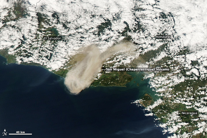 |
Figure 11. Volcanic ash from the eruption traveled more than 70 km downwind to the SW on 29 December 2013. It also traveled ENE of the volcano at higher elevations. Courtesy of NASA Earth Observatory (Jeff Schmaltz, LANCE/EOSDIS MODIS Rapid Response Team). |
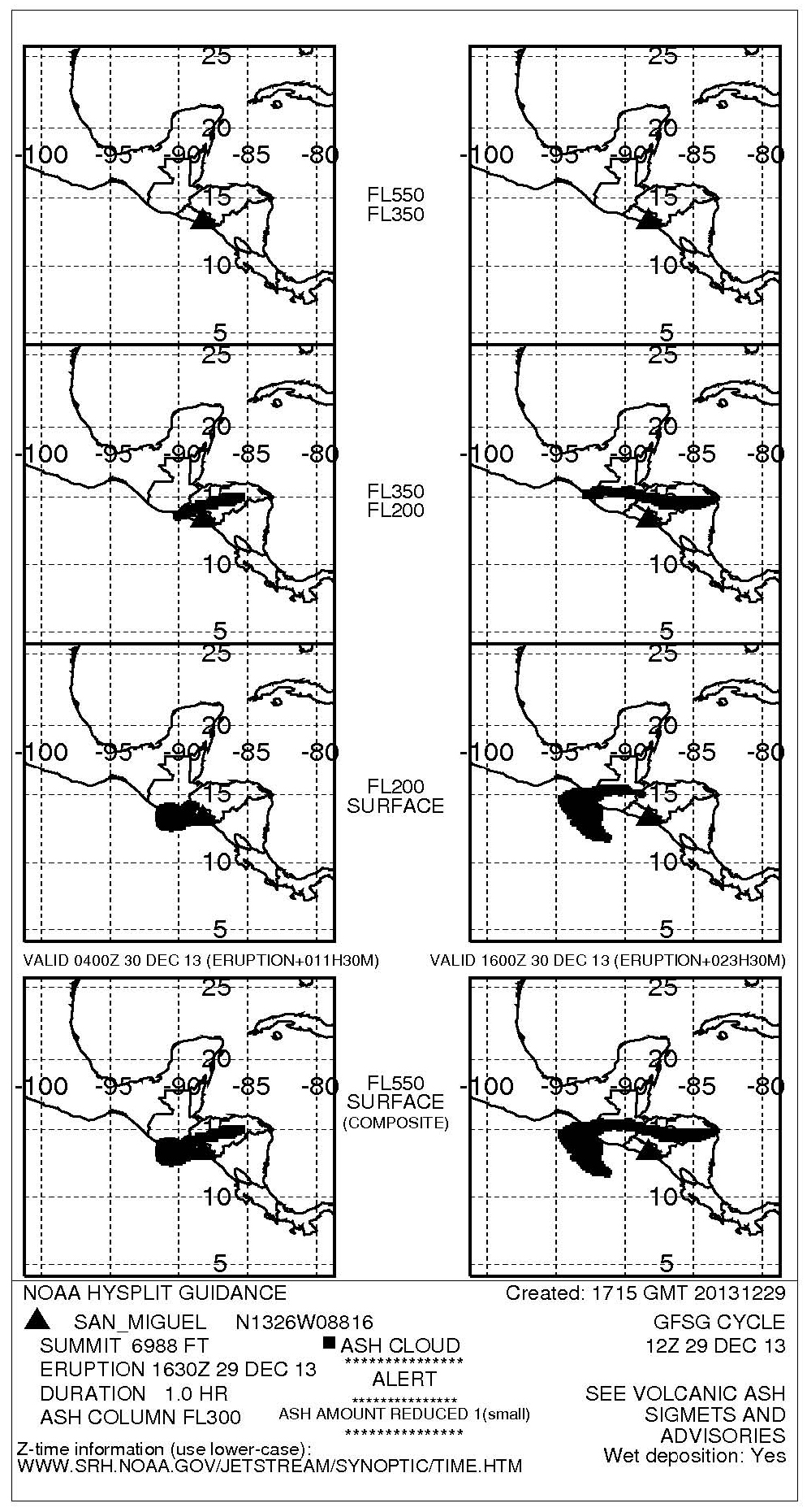 |
Figure 12. NOAA ash column map showing ash cloud dispersion in different directions. From the surface to 6 km, the cloud drifted W, and between 6 and 10 km the cloud drifted ENE.Courtesy of Washington Volcanic Ash Advisory Center. |
On 31 December MARN geoscientists estimated that the eruption deposits around the crater were about 50 cm thick. There was no incandescense at the crater, increase in emissions, or an increase in fumarole temperature prior to the eruption. The seismic stations recorded a sudden and dramatic increase in RSAM values at the time of the eruption. Only a very small increase in the average RSAM values was observed mid-December (figure 13).
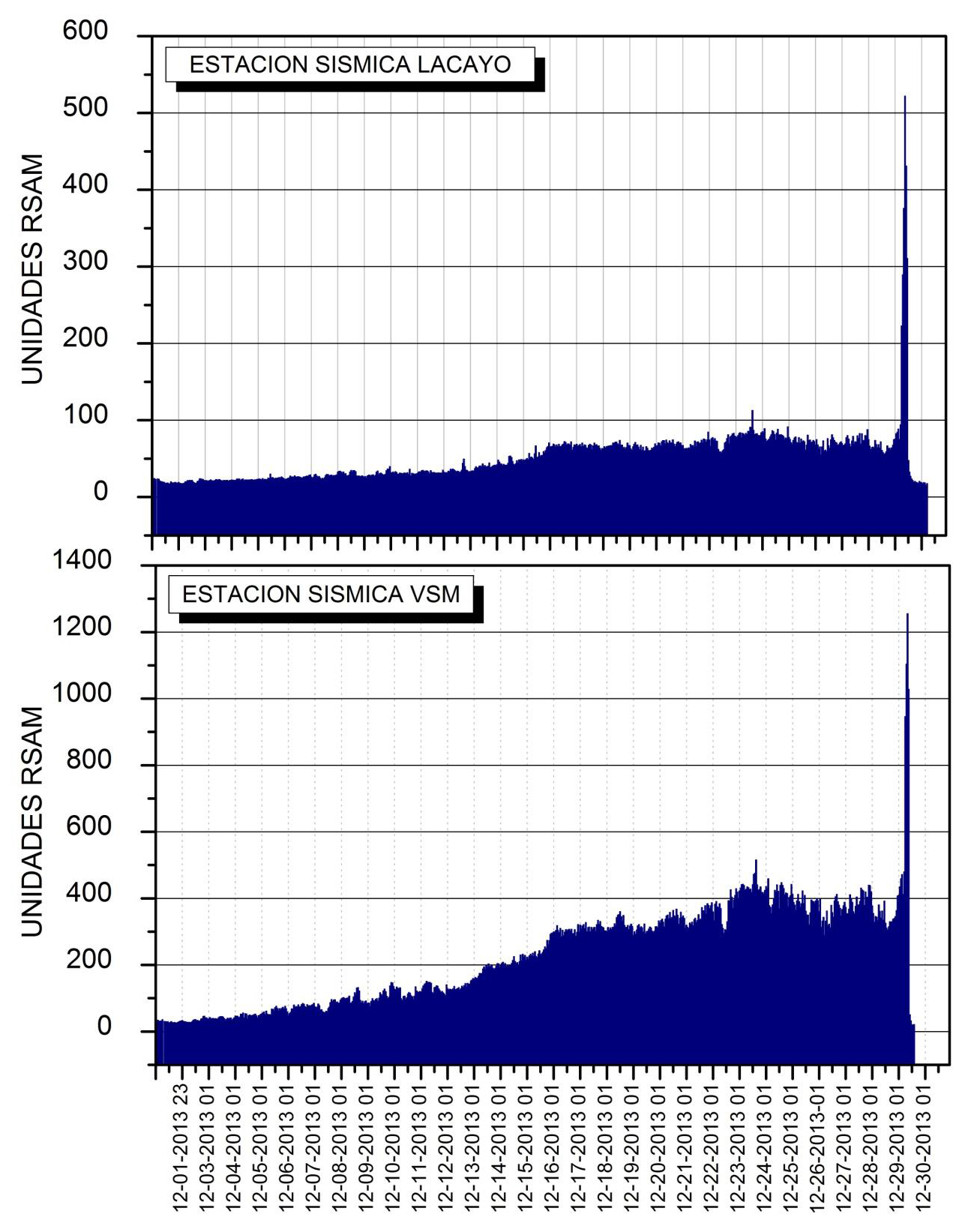 |
Figure 13. RSAM values from two seismic stations on the flanks of San Miguel for December 2013. They show a slight increase in average RSAM values in mid-December and the sudden spike on the morning of the eruption, 29 December. Figure from MARN Special Report. |
The sudden spike in RSAM values on 29 December was similar to seven prior spikes that were not associated with eruptions between October 2006 and December 2013 (figure 14).
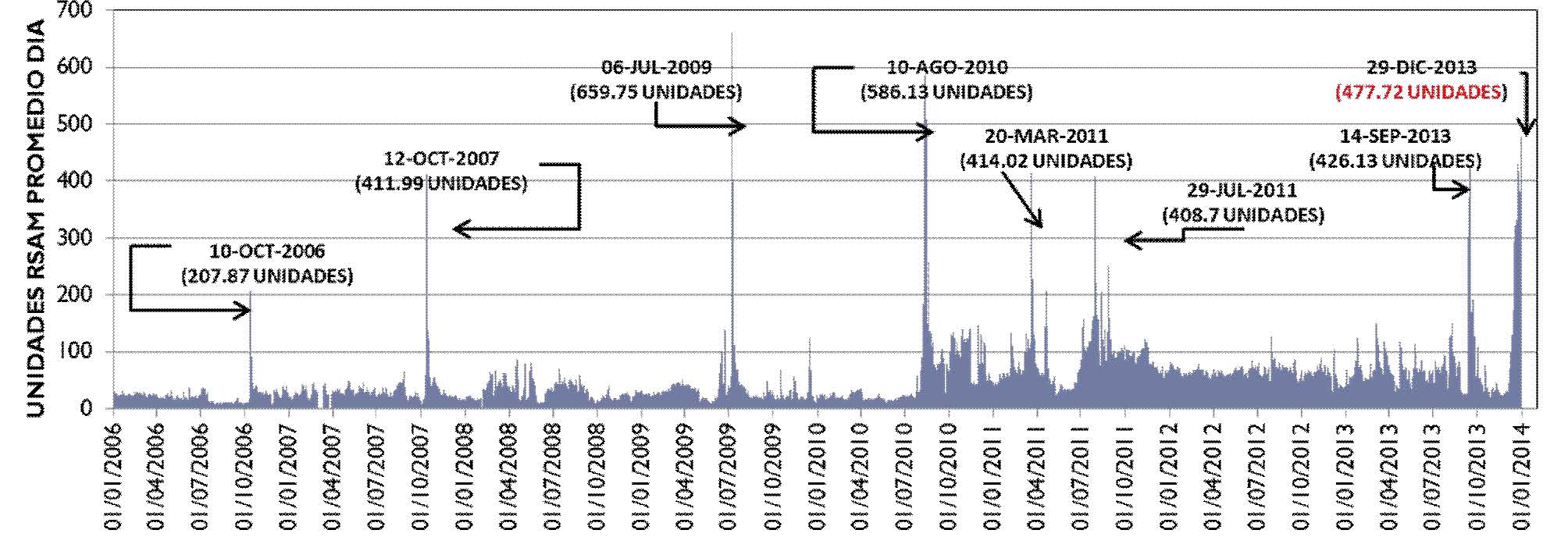 |
Figure 14. Daily average RSAM values from 1 January 2006 through 1 January 2014. Seven similar spikes of RSAM values during this time were not associated with eruptions. Figure from MARN special report. |
Hourly RSAM values recorded on 29 December show an increase above background levels at 0700, only three and a half hours before the eruption. By 1300 values had dropped back below previous levels. SNET reported that sulfur dioxide flux increased from 637 tons per day on 29 December, peaking at 2200 t/day on 31 December.
Ashfall deposits were observed in Santiago de Maria (1 mm), Placitas (5 mm) and San Jorge (2 mm) (figure 15).
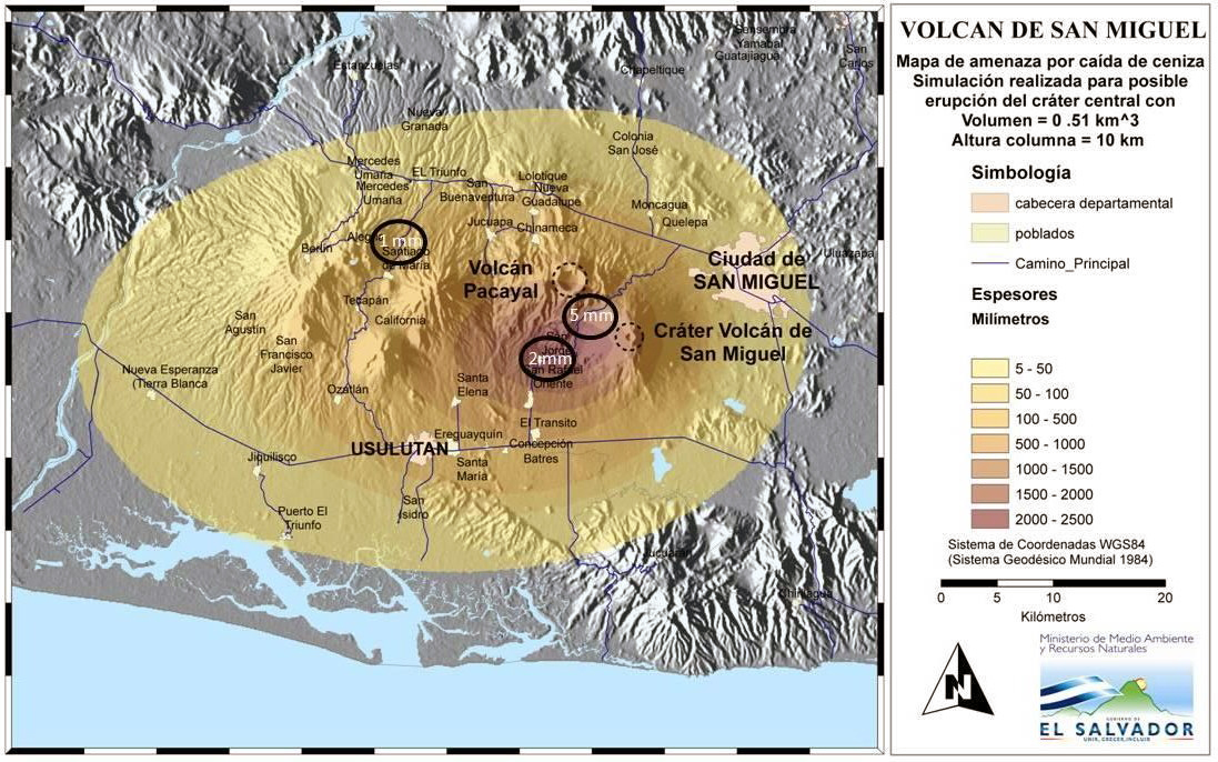 |
Figure 15. Ashfall hazard map with data points and simulation of the eruption from the central crater, with a volume of .51 km3 and a 10 km high plume. Figure from MARN Special Report. |
Activity during 2014. RSAM values quickly dropped back to normal levels within hours after the 29 December eruption. In January light-gray gas plumes continued to rise 100-250 m above the crater and drift generally S and SW. A spike to 262 RSAM units was attributed to a magma injection on 23 January. Small magnitude earthquakes (179) continued in the volcano area in February. Average RSAM values steadily increased from mid-January to late February from values below 200 to over 400 before dropping back below 200 at the beginning of March 2014. White and light-gray plumes rising to 300 m were reported in February and March. A small explosion occurred at 1644 on 12 February, but no additional information was given by MARN. Moderate SO2 emissions were also reported during this time. Decreasing seismicity was recorded in March and April.
SNET reported that on 12 April moderate-to-strong gas plumes rose from the crater and drifted SW. The biggest plume occurred at 1607 and rose 400 m. Images recorded by a webcam showed that the plumes had dark tones, suggesting small amounts of ash. Another plume, rising between 400 and 600 m was recorded on 29 April with the thermal camera, but visual observations were obscured by weather conditions.
The volcano was more active from May to July 2014 with at least nine episodes of ashfall reported. The firstwas observed in areas between the Parque de las Placitas and Placitas on 10 May with deposits less than 1 mm thick. From 18-20 May, an increase in the frequency and magnitude of gas emissions, rumbling in the crater, and small explosions were followed by juvenile ashfall. Less than 1 mm of ash fell about 9 km to the WSW of the volcano in San Jorge on 18 May. On 19 and 20 May the webcam recorded periodic pulses of gray gas plumes that rose 300 m and drifted W. During 22-23 May MARN reported that heavy rains at San Miguel caused lahars that originated from the upper part of the volcano and were heard by residents. Seismicity and gas output both remained high during this time, with gas plumes rising 300 m and drifting W. Locals observed gas plumes with occasional minor amounts of ash rising from the crater, especially after rainfall. Rumbling was also reported. The RSAM average values in late May and June were higher than those recorded during the 29 December and 12 February eruptions, raising concerns of a new eruption.
Strombolian activity in June and July was characterized by sudden fluctuations in seismicity (figures 16). Ash emissions during 4, 5 and 6 June caused millimeter-scale ash deposits in areas 3 km N, NW and SW of the crater. On 8 June, 1 mm of ashfall was reported on the N flank. An inspection of the crater on 10 June revealed strong degassing with plumes rising to 200 m, 2 cm of gray ash deposits, and the temperature of the fumaroles at 200°C. Ash emissions were also reported 28, 29 and 30 June. In July seismicity at San Miguel remained intermittently high, especially beneath the N flank, and RSAM reached over 1000 units for 10 consecutive days. A small explosion on 13 July at 0941 sent ash to the WSW. The following day, 1-mm-thick, dark-gray ash deposits were observed on the LACAYO farm, 4 km WSW. On 23 July at 1831 another ash cloud from a small explosion rose 400 m and drifted SW. Minutes later, local observers reported ashfall in the Cantons of La Morita (6 km SW) and Piedra Azul, and also in San Rafael Oriente (11 km SW). At 1806 on 25 July and 2018 on 27 July two additional smaller ash-and-gas explosions occurred. A longer gas-and-ash explosion, lasting fifteen minutes occurred on 28 July at 0615. Both the 27 and 28 July explosions rose between 300 and 500 m and drifted SW. Local and Civil Protection of San Jorge observers reported millimeter depth ashfall from these two events in the cantons of La Morita, La Piedrita, and La Ceiba, located WSW of the crater. These were the last reported ash emissions in 2014.
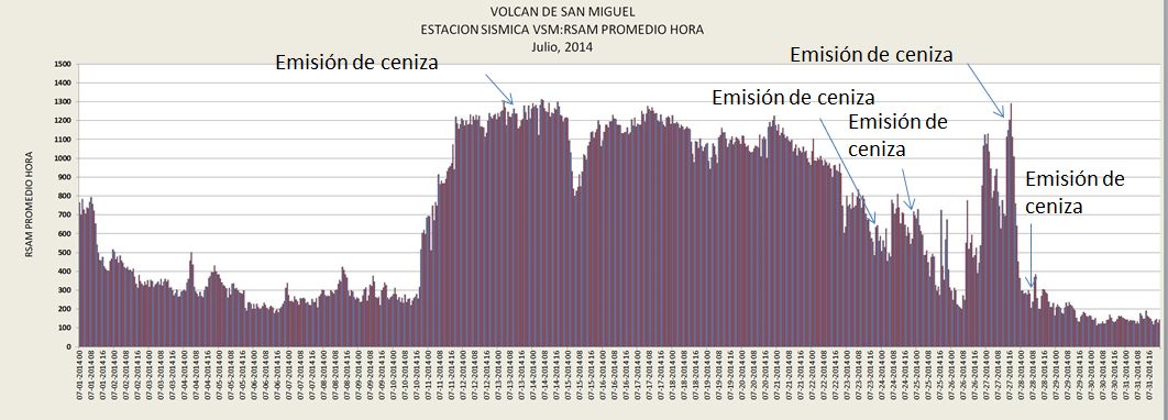 |
Figure 16. Average hourly RSAM values from the VSM seismic station and ash emissions (Emision de ceniza) for July 2014. Courtesy of SNET. |
Activity at San Miguel showed signs of decreasing in August 2014; fewer days of elevated SO2 and above-baseline RSAM were recorded, no ash emissions were reported, and only white or whitish gray steam or steam-and-gas plumes (interpreted by MARN as water vapor and SO2 emissions) rose 100-200 m above the crater. Heavy rains during 10-11 August generated two landslides along the creeks that flow down the SW and NE flanks of the volcano, causing some damage to the small communities in the region, including San Jorge located 9 km WSW of the summit. SO2 emissions and seismicity spiked briefly from 31 August to 5 September (RSAM spiked to 1113 on 2 September, SO2 reached 1135 t/d). Mudslides caused minor damage in early September.
Through December 2014 activity remained slightly elevated with RSAM values ranging between 50 and 387 units (figure 17), pulses of SO2 emissions spiking to 1739 t/day, gas plumes rising no more than 400 m above the crater, and smaller numbers of earthquakes. There were no reports of explosions with ash emissions, and no significant change in the temperature inside the crater during this time.
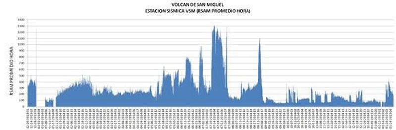 |
Figure 17. Hourly average RSAM values from the VSM Seismic Station from 20 December 2013, just prior to the 29 December eruption, through the end of December 2014. The vertical scale goes to 1400 RSAM. Average values decreased significantly after August 2014. |
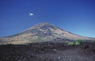
Geological Summary. The symmetrical cone of San Miguel, one of the most active volcanoes in El Salvador, rises from near sea level to form one of the country's most prominent landmarks. A broad, deep, crater complex that has been frequently modified by eruptions recorded since the early 16th century caps the truncated unvegetated summit, also known locally as Chaparrastique. Flanks eruptions of the basaltic-andesitic volcano have produced many lava flows, including several during the 17th-19th centuries that extended to the N, NE, and SE. The SE-flank flows are the largest and form broad, sparsely vegetated lava fields crossed by highways and a railroad skirting the base of the volcano. Flank vent locations have migrated higher on the edifice during historical time, and the most recent activity has consisted of minor ash eruptions from the summit crater.
Information Contacts: Servicio Nacional de Estudios Territoriales (SNET), Km. 5 1/2 carretera a Santa Tecla y Calle las Mercedes, contiguo a Parque de Pelota, Edificio SNET, Apartado Postal #27, Centro de Gobierno, El Salvador 2283-2246 (URL: http://www.snet.gob.sv/); Reuters (URL: http://www.reuters.com/, http://news.yahoo.com/el-salvador-volcano-erupts-evacuations-ordered-194649069.html); Washington Volcanic Ash Advisory Center (VAAC), Satellite Analysis Branch (SAB), NOAA/NESDIS E/SP23, NOAA Science Center Room 401, 5200 Auth Rd, Camp Springs, MD 20746, USA (URL: http://www.ospo.noaa.gov/Products/atmosphere/vaac/); NASA Earth Observatory, EOS Project Science Office, NASA Goddard Space Flight Center, Goddard, Maryland, USA (URL: http://earthobservatory.nasa.gov/)