Report on San Cristobal (Nicaragua) — September 2015

Bulletin of the Global Volcanism Network, vol. 40, no. 9 (September 2015)
Managing Editor: Edward Venzke.
Edited by A. Elizabeth Crafford.
San Cristobal (Nicaragua) Intermittent explosions of gas and minor ash emissions, February 2014-August 2015
Please cite this report as:
Global Volcanism Program, 2015. Report on San Cristobal (Nicaragua) (Crafford, A.E., and Venzke, E., eds.). Bulletin of the Global Volcanism Network, 40:9. Smithsonian Institution. https://doi.org/10.5479/si.GVP.BGVN201509-344020
San Cristobal
Nicaragua
12.702°N, 87.004°W; summit elev. 1745 m
All times are local (unless otherwise noted)
Intermittent ash and gas explosions have occurred at San Cristóbal since a moderate explosion on 8 September 2012 (BGVN 37:08). Subsequent explosions were reported on 25-28 December 2012, 7 June 2013, and 17 January 2014 (BGVN 38:01 and 38:12), often with ash falling on nearby communities. Between 18 January 2014 and August 2015 several additional moderate gas and ash explosions occurred, along with hundreds of smaller gas explosions. Information in this report came from monthly reports, briefing notes, and daily news bulletins issued by the Instituto Nicaragüense de Estudios Territoriales (INETER), and the Washington VAAC (Volcanic Ash Advisory Center).
Activity during 2014. INETER reported that a gas emission with small amounts of ash rose from San Cristóbal between 0641 and 0850 on 4 February 2014. The number of seismic events dropped dramatically from 9,328 in February to only 82 in March, primarily recording degassing events. No explosions occurred in March, and fluctuations in SO2 output corresponded to variations in RSAM values.
Based on analysis of satellite images, the Washington VAAC reported that on 11 April 2014 a gas plume that possibly contained small amounts of ash drifted 20 km W from the summit; no altitude was given. A thermal anomaly was present in short-wave infrared (MODIS/MODVOLC) satellite images.
Two lahars were recorded on June 1 on the seismographs, but they caused no significant damage.
According to the July 2014 INETER monthly report, two gas-and-ash explosions occurred on 20 July, one at 1331 and a second at 1413. The column of ash and gas from the first explosion reached a height of 1,000 m and drifted W and SW. Ash from the second, smaller explosion reached several communities W and NW of the volcano, including El Viejo (18 km SW), Rancherias (8 km NW), and sections of the Panamerican Highway to the W and NW.
In August INETER staff observed gas mixed with a small amount of ash emitting from fumaroles on the northeast wall of the crater. The plumes did not rise above the crater rim. A small lahar occurred on the west side of San Cristobal on 24 September.
At 1130 on 1 October 2014 a sharp increase in seismicity was followed 10 minutes later by a series of explosions lasting less than 10 minutes. Small amounts of ash drifted N toward Santa Cruz, Rancheria, and San Jose del Obraje (10 km N).
Activity during 2015. After a few months of relative calm, small gas plumes, detected by the seismic stations on the flank of the volcano, rose a few meters above the crater rim on 19 and 23 January 2015. Correlation of SO2 emissions, RSAM values and the exhalations are shown in figure 31.
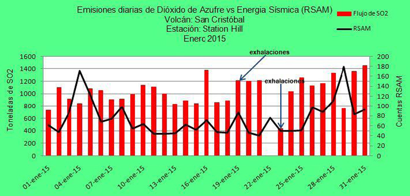 |
Figure 31. Graph of SO2 emissions, RSAM values of seismic energy, and the dates of small gas explosions from January 2015. Courtesy of INETER. |
Gas emissions were reported as moderate and abundant for February 2015, with plumes drifting WSW and NW just above the crater.
On 5 March 2015 at 1445 a series of explosions sent ash 500 m above the crater according to INETER. Visual inspection of the crater in April revealed strong hydrothermal alteration in the rocks and soil of the southern part of the crater, and collapse of portions of the crater floor from the explosions in March. Most of the 3,147 seismic events recorded in April were related to degassing (2,372); no ash plumes were reported. A slight decrease in the number of seismic events, to 2,812 was recorded in May 2015.
Explosive activity resumed in June 2015 with two series of explosions. On 6 June, about 41 explosions occurred between 1354 and 1625. The strongest one was at 1355, and generated an ash plume that rose 200 m above the crater rim; ashfall was reported in Chinandega (15 km SW). On 12 June a larger explosion at 0907 generated a gas-and-ash plume that rose 2,000 m and drifted SE, but ashfall was not reported. A second explosion that day at 1835 produced a gas plume with low ash content; the height of the plume could not be determined due to heavy rain. Seismic signals detected a lahar a few minutes later between 1850 and 1929; an observer reported that the small lahar descended the W and SW flanks. No further explosions were reported through August 2015.
Geological Summary. The San Cristóbal volcanic complex, consisting of five principal volcanic edifices, forms the NW end of the Marrabios Range. The symmetrical 1745-m-high youngest cone, named San Cristóbal (also known as El Viejo), is Nicaragua's highest volcano and is capped by a 500 x 600 m wide crater. El Chonco, with several flank lava domes, is located 4 km W of San Cristóbal; it and the eroded Moyotepe volcano, 4 km NE of San Cristóbal, are of Pleistocene age. Volcán Casita, containing an elongated summit crater, lies immediately east of San Cristóbal and was the site of a catastrophic landslide and lahar in 1998. The Plio-Pleistocene La Pelona caldera is located at the eastern end of the complex. Historical eruptions from San Cristóbal, consisting of small-to-moderate explosive activity, have been reported since the 16th century. Some other 16th-century eruptions attributed to Casita volcano are uncertain and may pertain to other Marrabios Range volcanoes.
Information Contacts: Instituto Nicaragüense de Estudios Territoriales (INETER), Apartado Postal 2110, Managua, Nicaragua (URL: http://www.ineter.gob.ni/); Washington Volcanic Ash Advisory Center (VAAC), Satellite Analysis Branch (SAB), NOAA/NESDIS E/SP23, NOAA Science Center Room 401, 5200 Auth Rd, Camp Springs, MD 20746, USA (URL: http://www.ospo.noaa.gov/Products/atmosphere/vaac/); Sistema Nacional para la Prevención, Mitigación y Atención de Desastres (SINAPRED) (URL: http://www.sinapred.gob.ni/).