Report on Rinjani (Indonesia) — August 2016
Bulletin of the Global Volcanism Network, vol. 41, no. 8 (August 2016)
Managing Editor: Edward Venzke.
Edited by A. Elizabeth Crafford.
Rinjani (Indonesia) Ash plumes rose to 6 km and lava flowed into lake, 25 October through 24 December 2015
Please cite this report as:
Global Volcanism Program, 2016. Report on Rinjani (Indonesia) (Crafford, A.E., and Venzke, E., eds.). Bulletin of the Global Volcanism Network, 41:8. Smithsonian Institution. https://doi.org/10.5479/si.GVP.BGVN201608-264030
Rinjani
Indonesia
8.42°S, 116.47°E; summit elev. 3726 m
All times are local (unless otherwise noted)
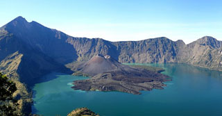
The Rinjani stratovolcano is located on the island of Lombok, at the western edge of the Lesser Sunda Islands of Indonesia. A large eruption in 1257 CE created a caldera on the W side of the summit crater; Barujari cone emerged there and has been the site of moderate explosive activity and lava flows every few decades since historical recording of the activity began in 1846. A large crescent-shaped lake, Segara Anak, fills the W portion of the caldera. Rinjani was quiet after eruptions during early October 2004, until 2 May 2009 when activity began again. Thermal anomalies were recorded through 20 May 2010, and the last ash eruptions were reported during 22-23 May, 2010.
A new eruption began at Barujari with an ash plume that rose to 3 km altitude on 25 October 2015. Eruptions were nearly continuous until 24 November when activity began to decline; the last ash plume reported by Darwin VAAC was on 5 December 2015, and PVMBG reported ash plumes through 24 December. Lava also flowed down the NE flank of the cone into Lake Segara Anak, raising the water level by one meter. Reports from Indonesia's Pusat Vulkanologi dan Mitigasi Bencana Geologi (PVMBG), or Center for Volcanology and Geological Hazard Mitigation (CVGHM ), National Disaster Management Agency (BNPB), and the Darwin VAAC (Volcanic Ash Advisory Center) are summarized below, along with MODVOLC and MIROVA thermal anomaly and Aura/OMI SO2 emissions data.
Indonesian government observations (PVMBG and BPNB). After the last explosions of 22-23 May 2010, seismic activity decreased steadily, and in November 2010 PVMBG reduced the Alert level to Normal or 1 (on a scale of 1-4), citing no activity visually observed since August 2010. There were no more reports of activity from PVMBG until 25 October 2015. The eruption was observed at 1045 local time (figure 24). It generated an ash plume that rose 200 m above the Barujari crater (2,500 m altitude), inside the caldera. Ash fell primarily on the SW flanks of the cone. PVMBG noted that no seismic or surficial precursory events were detected. The Alert Level was raised to 2 (on a scale of 1-4).
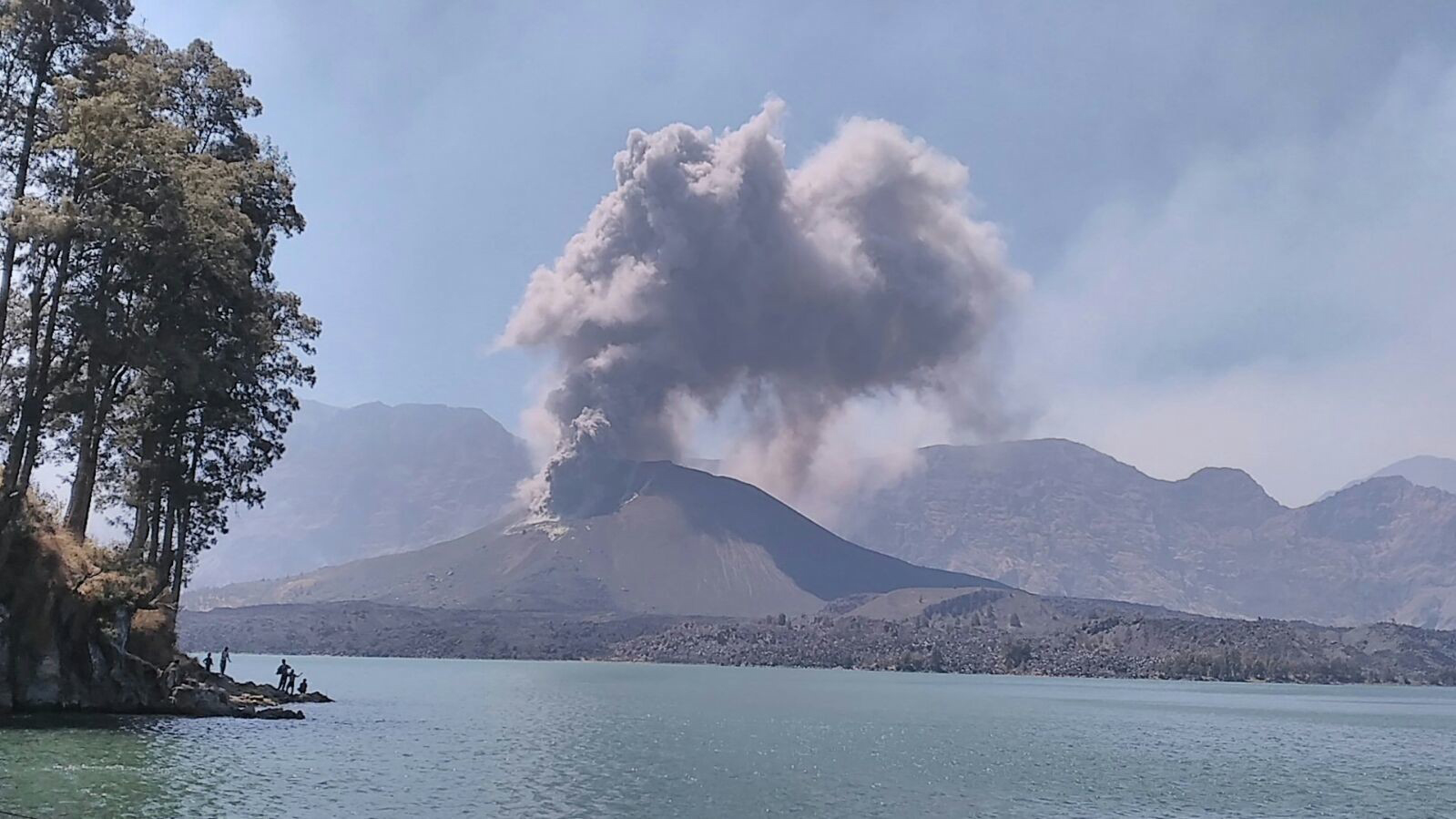 |
Figure 24. Eruption of the Barujari cone of Rinjani, 25 October 2015 at 1045 local time (WITA). View from the northern shore of Lake Segara Anak inside the Rinjani caldera. Courtesy of CVGHM (Report, 26 October 2015). |
In the days following the 25 October eruption, gas, ash, and steam plumes were noted by PVMBG rising 900 m above Barujari. From 1 to 5 November, ash plumes were observed daily rising still higher, to 2,000 m above Barujari, or 4.3 km altitude. The amplitude of the seismic tremors increased after the initial eruption, and continuous tremor began on 2 November, correlating with the observed continuous emissions. The explosions produced ash, pyroclastic fallout around the cone, and a lava flow that traveled down the NE side of the cone and onto the crater floor. Ashfall in seven villages in the North Lombok Regency (the NW quadrant of the island) was reported by BNPB on 3 November, and ash plumes that drifted W and SW caused three airports to close during 3-4 November: Ngurah Rai (150 km WSW) in Bali, Selaparang Airport (40 km WSW) in Lombok, and Blimbingsari Airport (230 km W) in Banyuwangi, East Java. Night incandescence was observed from the webcamera on 4 November.
Between 7 and 13 November both steam and ash plumes were observed rising to 2,600 m above Barujari cone (to 5 km altitude), and additional lava flows were observed flowing into the caldera from the NW side of the cone. The earlier NE lava flow reached Lake Segara Anak and the inner wall of the caldera, creating steam plumes. An ash deposit less than 1 mm thick was observed on Lombok Island during this period. The ESE part of Bali Island immediately to the W of Lombok Island also reported minor ashfall (
PVMBG recorded a change in seismicity beginning on 2 November, interpreted as indicating a change to more effusive activity and smaller Strombolian-type explosions. Strombolian explosions ejected material 30-150 m above Barujari crater during November. The lava flowing into the lake raised the water level one meter, causing a doubling of the flow rate in the Kokok Putih River (measured 10 km NE of the lake at a hydropower station), but no flooding was reported. PVMBG estimated a VEI of 2 for the eruption.
Between 25 November and 25 December 2015, tremor was elevated but not constant, and the signals dropped back down to background levels after 25 December. Plumes of steam and ash continued to be observed through 24 December, rising from 50 to 2,500 m above the crater. From 25 December through 18 January 2016, only white steam plumes rising to 50 m above the crater were observed, prompting CVGHM to lower the Alert Level to 1 on 19 January 2016.
Darwin VAAC reports. The first ash plumes from the eruption reported by Darwin VAAC were observed on satellite images late on 25 October 2015, rising to 3 km altitude and drifting 45-75 km SW and WSW. Ash plumes continued rising daily to over 4 km and drifting as far as 350 km NW, W, WSW, and SW into early November. The explosion rate and intensity continued to increase, and an ongoing ash plume was observed during 3-5 November that Darwin VAAC reported was visible at 6 km altitude for over 24 hours; it drifted as far as 740 km generally W and S. Multiple daily VAAC reports of ash plumes were issued through the end of November; altitudes remained generally between 3.7 and 4.3 km, drifting as far as 240 km generally W. A decline in activity was reported on 23 November, and the last VAAC report was on 5 December; the ash plume was reported to be at 3.7 km altitude, drifting 75 km SW.
Thermal anomalies and SO2 data. Two 3-pixel MODVOLC thermal anomalies were observed near the summit of Rinjani between late May 2010 and November 2015. The first, on 21 October 2012, was located between the Barujari cone and the summit. The second, on 8 November 2013, was located over the N edge of the caldera rim. Both were within the large summit caldera well, but there were no associated reports of volcanic activity.
The first anomaly data from the MODVOLC thermal alerts system that was likely associated with the October 2015 eruption appeared on 2 November 2015 in the area N of Barujari cone where the lava flow was reported. Thermally anomalous pixels were recorded on 20 days through 29 November 2015. The MIROVA (Middle InfraRed Observation of Volcanic Activity) system shows a spike in radiative power in late October, and then records a rapid decline and cessation in the first few days of December 2015 (figure 25).
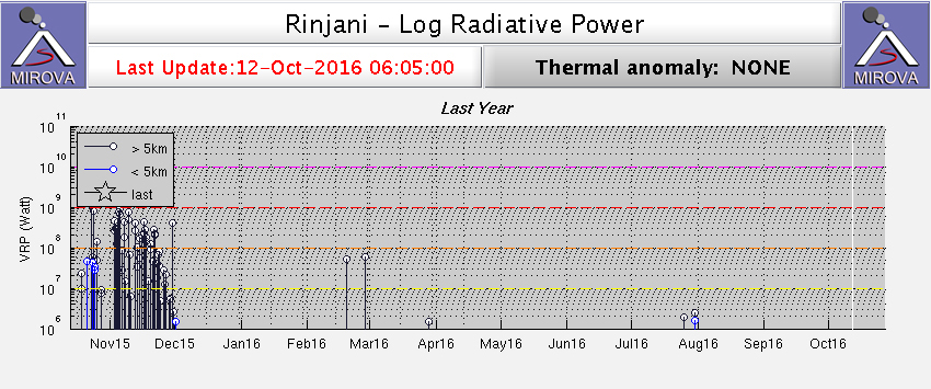 |
Figure 25. MIROVA (Middle InfraRed Observation of Volcanic Activity) system graph of Log Radiative Power of heat flow from Rinjani between 13 October 2015 and 12 October 2016, showing high levels of radiative power beginning in late October that end around 1 December 2015. Courtesy of MIROVA. |
Images captured by the OMI instrument on the Aura satellite show the SO2 emissions associated with the eruption. An SO2 anomaly was first captured on 3 November 2015. The strongest, on 8 November (figure 26), measured a mass of 1.190 kilotons of SO2. The last emission clearly associated with Rinjani was acquired on 15 November 2015.
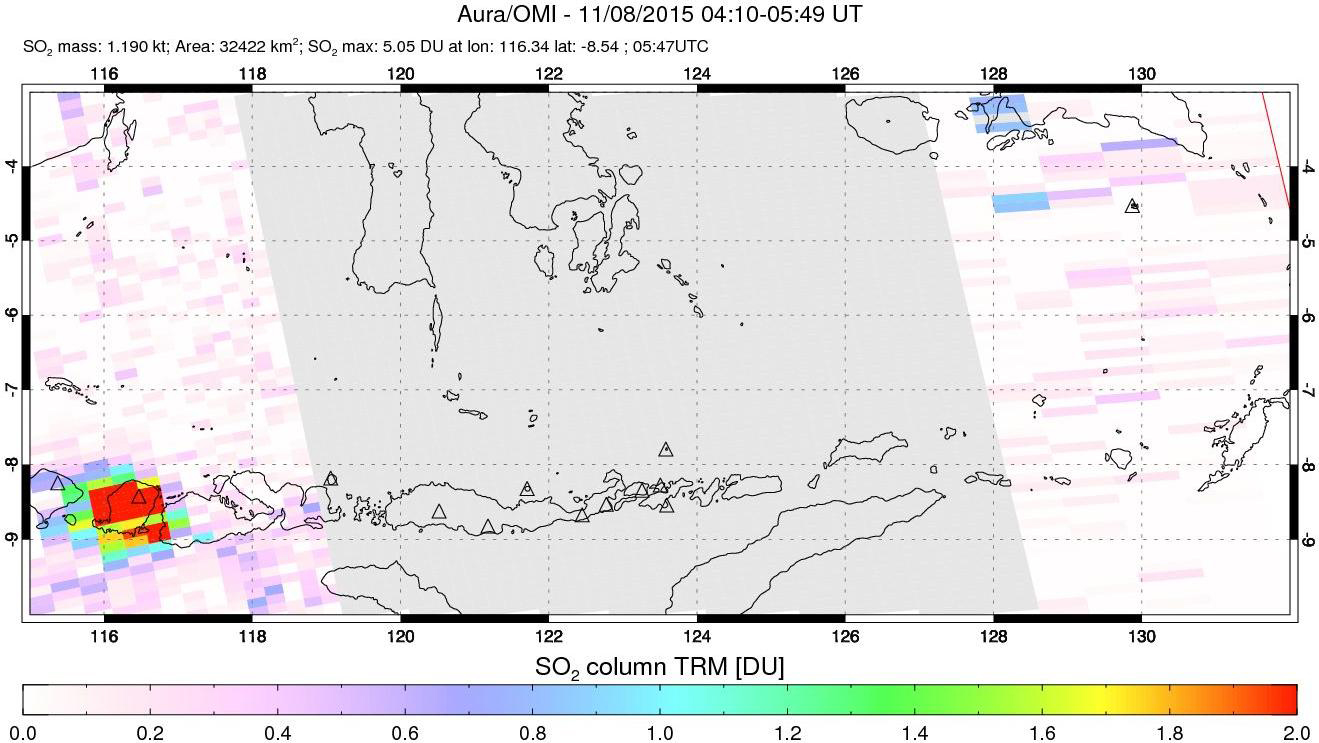 |
Figure 26. Aura/OMI SO2 emission data acquired 8 November 2015 for Rinjani. SO2 mass: 1.190 kilotons; Area: 32422 km2; SO2 max: 5.05 DU at Ion: 116.34 lat: -8.54; 0547 UTC. Images of emissions were captured several times between 3 and 15 November 2015. Courtesy of NASA Goddard Space Flight Center. |
Geological Summary. Rinjani volcano on the island of Lombok rises to 3726 m, second in height among Indonesian volcanoes only to Sumatra's Kerinci volcano. Rinjani has a steep-sided conical profile when viewed from the east, but the west side of the compound volcano is truncated by the 6 x 8.5 km, oval-shaped Segara Anak (Samalas) caldera. The caldera formed during one of the largest Holocene eruptions globally in 1257 CE, which truncated Samalas stratovolcano. The western half of the caldera contains a 230-m-deep lake whose crescentic form results from growth of the post-caldera cone Barujari at the east end of the caldera. Historical eruptions dating back to 1847 have been restricted to Barujari cone and consist of moderate explosive activity and occasional lava flows that have entered Segara Anak lake.
Information Contacts: Pusat Vulkanologi dan Mitigasi Bencana Geologi (PVMBG, also known as Indonesian Center for Volcanology and Geological Hazard Mitigation, CVGHM), Jalan Diponegoro 57, Bandung 40122, Indonesia (URL: http://www.vsi.esdm.go.id/); Darwin Volcanic Ash Advisory Centre (VAAC), Bureau of Meteorology, Northern Territory Regional Office, PO Box 40050, Casuarina, NT 0811, Australia (URL: http://www.bom.gov.au/info/vaac/); Badan Nasional Penanggulangan Bencana (BNPB), National Disaster Management Agency, Graha BNPB - Jl. Scout Kav.38, East Jakarta 13120, Indonesia (URL: http://www.bnpb.go.id/); Hawai'i Institute of Geophysics and Planetology (HIGP), MODVOLC Thermal Alerts System, School of Ocean and Earth Science and Technology (SOEST), Univ. of Hawai'i, 2525 Correa Road, Honolulu, HI 96822, USA (URL: http://modis.higp.hawaii.edu/); MIROVA (Middle InfraRed Observation of Volcanic Activity), a collaborative project between the Universities of Turin and Florence (Italy) supported by the Centre for Volcanic Risk of the Italian Civil Protection Department (URL: http://www.mirovaweb.it/); OMI (Ozone Monitoring Instrument), Global Sulfur Dioxide Monitoring, Atmospheric Chemistry & Dynamics, NASA Goddard Space Flight Center, Goddard, Maryland, USA (URL: https://so2.gsfc.nasa.gov/).