Report on Masaya (Nicaragua) — August 2016

Bulletin of the Global Volcanism Network, vol. 41, no. 8 (August 2016)
Managing Editor: Edward Venzke.
Edited by A. Elizabeth Crafford.
Masaya (Nicaragua) Lava lake returns in Santiago Crater, large thermal anomalies recorded, minor ash emissions
Please cite this report as:
Global Volcanism Program, 2016. Report on Masaya (Nicaragua) (Crafford, A.E., and Venzke, E., eds.). Bulletin of the Global Volcanism Network, 41:8. Smithsonian Institution. https://doi.org/10.5479/si.GVP.BGVN201608-344100
Masaya
Nicaragua
11.9844°N, 86.1688°W; summit elev. 594 m
All times are local (unless otherwise noted)
Nicaragua's Volcan Masaya, has an intermittent lava lake that has attracted visitors since the time of the Spanish Conquistadores. The unusual vent-filled basaltic caldera has had historical explosive eruptions in addition to lava flows and actively circulating magma at the lava lake. An eruption in April and May 2012 ejected ash to several hundred meters above the volcano, bombs as large as 60 cm around the crater, and ash fell to a thickness of 2 mm in some areas of the park. The Instituto Nicareguense de Estudios Territoriales (INETER), Sistema Nacional para la Prevencion, Mitigacion y Atencion de Desastres (SINAPRED), and the Washington Volcanic Ash Advisory Center (VAAC) monitor the volcano's activity and provide regular reports.
The period from October 2015 through August 2016 saw the re-emergence of the lava lake, increased seismic frequency and amplitude, intermittent explosive activity, and continued strong thermal anomalies from satellite and ground based sources as a result of the newly active lava lake.
Very little volcanic activity was reported by INETER between late 2012 and for most of 2015, although regular monitoring of seismicity, temperature, and gas emissions continued (BGVN 40:10). Renewed eruptive activity after two years of quiet began on 3 October 2015. The Washington VAAC reported that a possible ash emission on 3 October 2015 at 1215 (UTC) was detected in satellite imagery, with a plume extending about 30 km ENE of the summit near one km altitude. The volcano camera and seismic data were not available, and there was no report of activity from INETER due to damaged equipment.
The last time incandescence was reported from Santiago crater was on 12 October 2010 (BGVN 36:11), except for a brief observation reported in April 2013 (BGVN 40:10). INETER reported that on 11 December 2015 rising magma brought an incandescent lava lake into view once again (figure 46); the lava lake rose to near the surface at the S part of the crater floor and was visible and audible from the crater rim.
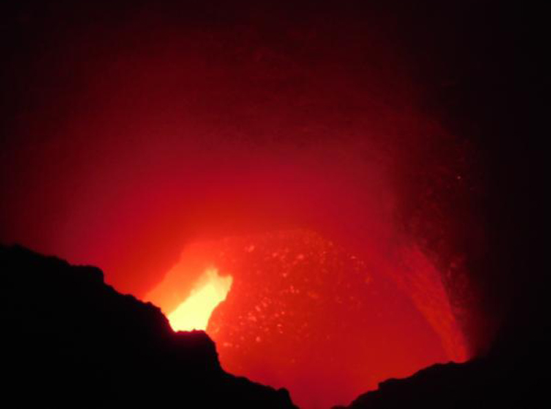 |
Figure 46. Incandescence observed at Santiago Crater at Masaya on 11 December 2015. Courtesy of INETER (Monthly Bulletin of Seismicity and Volcanoes of Nicaragua, December, 2015). |
Scientists conducting field work on 18 December 2015 observed that the vent hosting the lava lake had widened and sulfur dioxide (SO2) emissions had increased. A few days later, spatter from the lava lake was ejected from the vent and landed a few meters away on the crater floor. RSAM (Real-time Seismic Amplitude) levels were stable at low-to-moderate levels, but increased for the second half of December (figure 47).
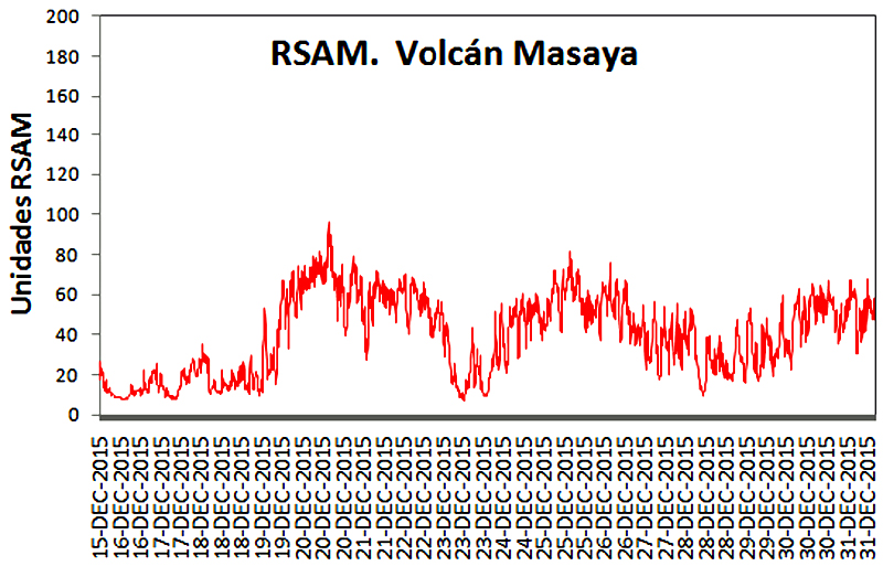 |
Figure 47. RSAM values increased at Masaya on 19 December 2015 from background values averaging 30 RSAM units to values as high as 90 during late December. Courtesy of INETER (Monthly Bulletin of Seismicity and Volcanoes of Nicaragua, December, 2015). |
The lava lake was first observed in satellite images beginning in January 2016. On 8 January very small explosions ejected tephra onto the crater floor. During a field visit in late January volcanologists noted that the lava lake had risen since the previous visit, and that a vent on the NE part of the floor was also incandescent. By late January RSAM values had increased to values between 400 and 800 units. A 70% increase in SO2 emissions was also recorded. On 29 January two lava lakes were prominent, and a third vent opened in the SE part of the crater floor. RSAM values remained moderate to high (80-620), and emissions were affecting vegetation downwind. During January and February the lava lake continued to be active with gas emissions (figure 48) that regularly rose 350-400 m above the crater and drifted generally W and SW, along with an increase in sounds as reported by observers. The size of the lava lakes grew in February and SO2 emissions increased, rising to 1,500 t/d during 10-11 February.
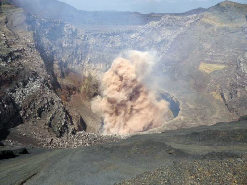 |
Figure 48. Explosion in Santiago Crater at Masaya, 17 February 2016. Photo by Guillermo Caravante; courtesy of INETER (Monthly Bulletin of Seismicity and Volcanoes of Nicaragua, February 2016) |
RSAM values were at high-to-very-high levels (up to 1,300 units) in late February and March. On 23 February small explosions again ejected spatter onto the crater floor; volcanologists observed active lava lakes in all three vents on the crater floor, and noted that the inner walls of the crater were being eroded by the lava lakes. Sporadic small streams of lava originated from the NE vent. By early March the two vents in the SW part of the crater had almost merged.
In late March activity within the lava lakes at the crater intensified and the vents continued to gradually widen as lake levels rose. INETER scientists observed several landslide deposits in the NE section of the crater. RSAM values remained at moderate-to-high levels. On 4 April SINAPRED (Sistema Nacional para la Prevencion, Mitigacion y Atencion de Desastres) noted that tremors continued and the widening of the vent in the SE part of the crater persisted. The lava lakes continued to strongly circulate and spatter during May and June, along with periodic seismic tremors and widely fluctuating RSAM values.
The Log Radiative Power data from MIROVA (Middle InfraRed Observation of Volcanic Activity) agreed well with the observations of the growing lava lakes and vigorous circulation at Santiago crater. They show the intensity of the thermal anomaly increasing from February to April 2016, and then maintaining moderate levels almost continuously through August 2016 (figure 49).
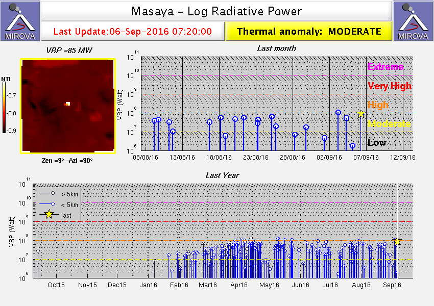 |
Figure 49. MIROVA thermal data for Masaya's Santiago crater, September 2015 through August 2016 showing moderate to high levels of heat flow at the crater beginning in late January 2016. The Volcanic Radiative Power (VRP) is a measurement of the heat radiated by the volcanic activity at the time of a satellite acquisition. It is calculated in Watts (W) and represents a combined measurement of the area of the volcanic emitter and its "effective radiating temperature" (higher than 600° K (327°C)). This "excess" radiance is linearly related to the radiative power of the volcano (http://www.mirovaweb.it). Courtesy of MIROVA. |
Likewise, MODVOLC anomalies for 2016 also clearly show the ongoing signature of the active lava lakes with over 100 hotspot pixels recorded between January and June 2016 (figure 50).
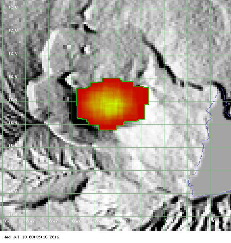 |
Figure 50. Over 100 thermally anomalous MODVOLC pixels from MODIS satellite data record the active lava lakes at Santiago crater at Masaya between January and the end of June 2016. Courtesy of Hawai'i Institute of Geophysics and Planetology (HIGP), MODVOLC Thermal Alerts System. |
During 27 to 29 June, geoscience staff of INETER together with geoscientists from Lamont Doherty Earth Observatory (LDEO) made thermometric measurements of the lava lake (figure 51). The measurements demonstrated that the temperatures in the lava lake are highest in the SE corner of the vent where the magma rises into the lake from the conduit below.
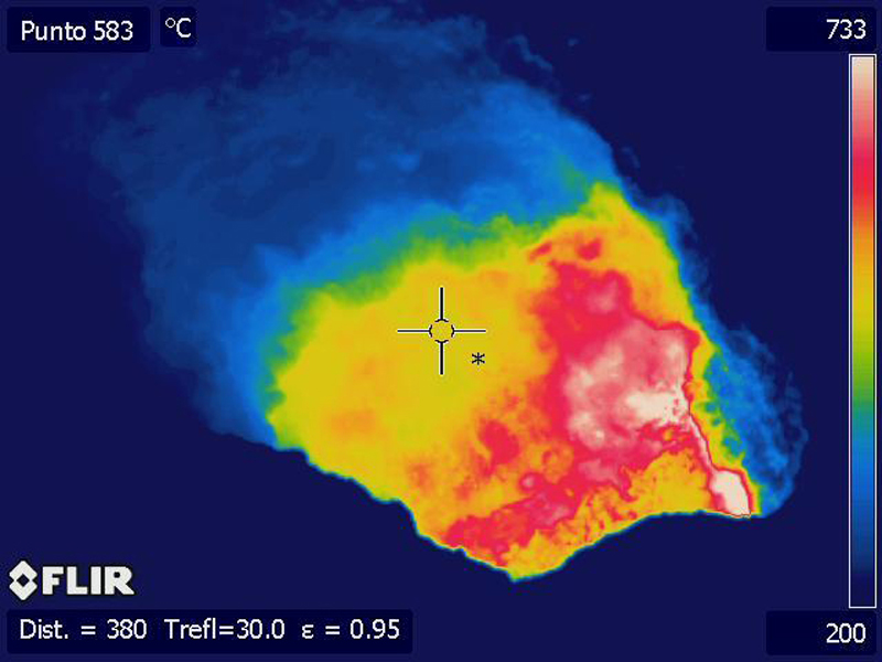 |
Figure 51. Thermal image of the lava lake in Santiago Crater at Masaya taken on 28 June 2016, using INETER's FLIRSC620 system. The hottest areas are in the SE corner of the lake, and the lava flows from there to the center of the lake as it cools. Courtesy of INETER (Monthly Bulletin of Seismicity and Volcanoes of Nicaragua, June 2016). |
On 15 August, Washington VAAC reported a possible ash emission from Masaya that rose to 1.8 km altitude (1,200 m above the summit) and drifted NW. Increased seismicity and thermal anomalies suggested continued activity at the Santiago Crater. The web camera view at the crater indicated that only minor ash was emitted, likely dissipating close to the summit. Gases and possible minor volcanic ash were again observed on satellite images at 1.8 km altitude by the Washington VAAC on 28 August, moving to the W.
Geological Summary. Masaya volcano in Nicaragua has erupted frequently since the time of the Spanish Conquistadors, when an active lava lake prompted attempts to extract the volcano's molten "gold" until it was found to be basalt rock upon cooling. It lies within the massive Pleistocene Las Sierras caldera and is itself a broad, 6 x 11 km basaltic caldera with steep-sided walls up to 300 m high. The caldera is filled on its NW end by more than a dozen vents that erupted along a circular, 4-km-diameter fracture system. The Nindirí and Masaya cones, the source of observed eruptions, were constructed at the southern end of the fracture system and contain multiple summit craters, including the currently active Santiago crater. A major basaltic Plinian tephra erupted from Masaya about 6,500 years ago. Recent lava flows cover much of the caldera floor and there is a lake at the far eastern end. A lava flow from the 1670 eruption overtopped the north caldera rim. Periods of long-term vigorous gas emission at roughly quarter-century intervals have caused health hazards and crop damage.
Information Contacts: Instituto Nicaragüense de Estudios Territoriales (INETER), Apartado Postal 2110, Managua, Nicaragua (URL: http://webserver2.ineter.gob.ni/vol/dep-vol.html); MIROVA, a collaborative project between the Universities of Turin and Florence (Italy) supported by the Centre for Volcanic Risk of the Italian Civil Protection Department (URL: http://www.mirovaweb.it/); Hawai'i Institute of Geophysics and Planetology (HIGP), MODVOLC Thermal Alerts System, School of Ocean and Earth Science and Technology (SOEST), Univ. of Hawai'i, 2525 Correa Road, Honolulu, HI 96822, USA (URL: http://modis.higp.hawaii.edu/); Washington Volcanic Ash Advisory Center (VAAC), Satellite Analysis Branch (SAB), NOAA/NESDIS E/SP23, NOAA Science Center Room 401, 5200 Auth Rd, Camp Springs, MD 20746, USA (URL: http://www.ospo.noaa.gov/Products/atmosphere/vaac/); Sistema Nacional para la Prevencion, Mitigacion y Atencion de Desastres, (SINAPRED), Edificio SINAPRED, Rotonda Comandante Hugo Chávez 50 metros al Norte, frente a la Avenida Bolívar, Managua, Nicaragua (URL: http://www.sinapred.gob.ni/).