Report on Rinjani (Indonesia) — January 2017
Bulletin of the Global Volcanism Network, vol. 42, no. 1 (January 2017)
Managing Editor: Edward Venzke.
Research and preparation by Jackie Gluck.
Rinjani (Indonesia) Ash eruptions on 1 August to 10 km altitude; explosions on 27 September 2016
Please cite this report as:
Global Volcanism Program, 2017. Report on Rinjani (Indonesia) (Venzke, E., ed.). Bulletin of the Global Volcanism Network, 42:1. Smithsonian Institution. https://doi.org/10.5479/si.GVP.BGVN201701-264030
Rinjani
Indonesia
8.42°S, 116.47°E; summit elev. 3726 m
All times are local (unless otherwise noted)
An eruption at Rinjani that lasted two months, between 25 October and 24 December 2015 (BVGN 41:08) included ash plumes rising to 6 km altitude and lava flows from the Barujari cone that reached the Segara Anak lake within the caldera. A new eruption that began on 1 August 2016 generated ash plumes to about 10 km altitude. After another period of quiet, small-scale explosive activity on 27 September stranded a number of trekkers on the slopes and caused the Alert level to be raised to 2. No further activity was reported in 2016.
Based on satellite and pilot observations, the Darwin VAAC reported that an eruption on 1 August 2016 generated an ash plume that rose to an altitude of 9.8 km altitude and drifted S. The ash plumes were first visible in satellite images at 1150, and according to the Pusat Vulkanologi dan Mitigasi Bencana Geologi (PVMBG, also known as the Centre for Volcanology and Geological Hazard Mitigation), passengers aboard a passing aircraft saw ash plumes rising 2 km above the crater (figure 27). The National Agency for Disaster Management (BNPB) noted that the Lombok International Airport closed at 1655 and was scheduled to reopen at 1000 the next day. Later on 1 August ash plumes rose to altitudes of 4.3-6.1 km altitude and drifted S, SW, and W. No plumes were visible at 1730; conditions had returned to normal levels, although BNPB warned that the public should stay at least 1.5 km away from the volcano.
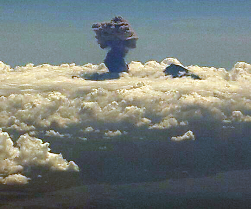 |
Figure 27. Photo taken by an airline passenger of the explosive eruption at Rinjani on 1 August 2016. The plume was described as rising about 2 km above the crater. Image has been color adjusted to enhance contrast. Courtesy of PVMBG. |
PVMBG reported that at 1445 on 27 September a small explosive eruption at Barujari Crater produced an ash plume rose that rose 2 km above the crater and drifted WSW. The eruption was preceded by an increase in seismicity, but the number and amplitude of the events were insignificant. The Alert Level was raised to 2, and the public was warned not to approach the crater within a 3-km radius.
Based on data from the Mount Rinjani National Park, BNPB reported that as many as 1,023 tourists were on Rinjani when it erupted on 27 September; officially only 464 people were registered to make the 3-day trek to the volcano and back. Officials began the evacuation of tourists that day.
The Jakarta Post reported on 1 October that the West Nusa Tenggara Disaster Mitigation Agency (BPBD NTB) had called on representatives of foreign countries to file a report if they had citizens still missing in the climbing area. The agency made the request following reports that 44 tourists had not yet returned from climbing the mountain. BPBD NTB head Muhammad Rum said it was possible that the climbers had returned, but had not yet been recorded, or had not passed through either of the two official entrances. The Jakarta Post reported on 5 December 2016 that hiking routes were once again open.
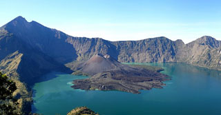
Geological Summary. Rinjani volcano on the island of Lombok rises to 3726 m, second in height among Indonesian volcanoes only to Sumatra's Kerinci volcano. Rinjani has a steep-sided conical profile when viewed from the east, but the west side of the compound volcano is truncated by the 6 x 8.5 km, oval-shaped Segara Anak (Samalas) caldera. The caldera formed during one of the largest Holocene eruptions globally in 1257 CE, which truncated Samalas stratovolcano. The western half of the caldera contains a 230-m-deep lake whose crescentic form results from growth of the post-caldera cone Barujari at the east end of the caldera. Historical eruptions dating back to 1847 have been restricted to Barujari cone and consist of moderate explosive activity and occasional lava flows that have entered Segara Anak lake.
Information Contacts: Pusat Vulkanologi dan Mitigasi Bencana Geologi (PVMBG, also known as Indonesian Centre for Volcanology and Geological Hazard Mitigation, CVGHM), Jalan Diponegoro 57, Bandung 40122, Indonesia (URL: http://www.vsi.esdm.go.id/); Darwin Volcanic Ash Advisory Centre (VAAC), Bureau of Meteorology, Northern Territory Regional Office, PO Box 40050, Casuarina, NT 0811, Australia (URL: http://www.bom.gov.au/info/vaac/); Badan Nasional Penanggulangan Bencana (BNPB), National Disaster Management Agency, Graha BNPB - Jl. Scout Kav.38, East Jakarta 13120, Indonesia (URL: http://www.bnpb.go.id/); Jakarta Post (URL: http://www.thejakartapost.com/).