Report on Semeru (Indonesia) — May 2017

Bulletin of the Global Volcanism Network, vol. 42, no. 5 (May 2017)
Managing Editor: Edward Venzke.
Edited by A. Elizabeth Crafford.
Semeru (Indonesia) Activity diminishes 2009-2013, active lava dome growth 2014-2016
Please cite this report as:
Global Volcanism Program, 2017. Report on Semeru (Indonesia) (Crafford, A.E., and Venzke, E., eds.). Bulletin of the Global Volcanism Network, 42:5. Smithsonian Institution. https://doi.org/10.5479/si.GVP.BGVN201705-263300
Semeru
Indonesia
8.108°S, 112.922°E; summit elev. 3657 m
All times are local (unless otherwise noted)
With hundreds of eruptive events in the 19th and early 20th centuries, and nearly continuous activity since 1967, Indonesia's Semeru is one of the world's most active volcanos. This activity has included lava flows, Vulcanian and Strombolian explosions, nuées ardentes, lava domes, and mudflows; fatalities and serious injuries occurred in 1981, 1994, 1997, and 2000.
Activity at the volcano is tracked by Pusat Vulkanologi dan Mitigasi Bencana Geologi (PVMBG), also known as Indonesian Center for Volcanology and Geological Hazard Mitigation, (CVGHM), the Darwin Volcanic Ash Advisor Center (VAAC), and remote sensing satellite data that provides visible imagery and thermal anomaly data. In this report, imagery and data from 2000-2009 is reviewed, along with details of activity from 2009 through March 2017.
Overview of activity since 2000. Strong evidence for continuous eruption at Semeru was gathered by satellite instruments from March 2000 through 2 January 2009. PVMBG reported ash explosions and an active lava dome in the Jonggring Seloko summit crater during early March 2009; after an ash plume on 15 March the gas and ash "gradually disappeared." A single MODVOLC thermal alert pixel was captured on 8 August 2009. PVMBG noted in their March 2010 report that the character of eruptive activity changed in April 2009 from ash-dominated explosions to emissions associated with dome growth. Only intermittent minor emissions were reported until incandescence appeared at the summit on 5 January 2010; strong thermal alert signals indicated continued lava-dome growth through November 2010. After 29 November 2010, there were no reports of unrest until small ash plumes were observed on 13 May 2011. These were followed by reports of pyroclastic flows in June, observations of the growing lava dome in September, and a new lava flow in December 2011.
Pyroclastic flows in January and February 2012 accompanied observations of incandescence and thermal alerts detected by satellite through mid-May. Small ash plumes from the summit area and incandescence at the lava dome were observed on 19 July 2012, but no further activity was noted until June 2013 when thermal alerts reappeared for about a month. An ash plume was reported by the Darwin VAAC in October 2013 and a thermal alert pixel appeared on 29 November 2013. After this, another break in activity occurred until the following spring.
PVMBG reported 22 incidents of emissions that were white to gray during March 2014, and 21 during 1-27 April 2014. They also reported eight explosions during April with white to gray emissions. A new, longer-lasting eruptive episode began with ash plumes, an incandescent lava flow, and rock avalanches that descended from the summit lava dome on 26 April 2014.
Thermal alert pixels reappeared on 5 June 2014 and remained abundant through 30 July 2016. During this time, the lava dome was actively growing and a lava flow slowly advanced down the S-flank Kembar ravine. Ash plume eruptions increased in frequency during 2015, and during 2016 they became large enough to produce aviation advisories from the Darwin VAAC several times. An image of the incandescent lava flow on the S flank in September 2016 and a thermal alert pixel in November 2016 suggested continuing dome growth through the end of the year. An ash plume reported by the Darwin VAAC on 9 January 2017 indicated continuing activity.
Satellite data from 2000-2009. From March 2000 through 2 January 2009, the University of Hawai'i's MODVOLC system recorded numerous thermally elevated pixels captured by the MODIS satellite instrument every single month except for February 2002. Explosive activity, lava avalanches, and pyroclastic flows were the sources of these abundant alerts (see previous BGVN reports). A NASA image from 14 June 2004 available in Google Earth clearly shows an ash plume erupting from Semeru and abundant ash deposited around its flanks (figure 20).
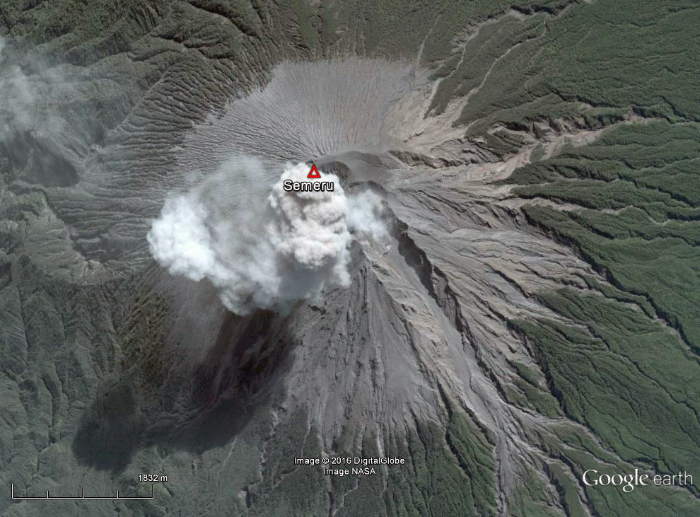 |
Figure 20. An ash plume rising from Semeru on 14 June 2004. Abundant recent ash deposits surround the summit, and steep ravines that carry pyroclastic flows and lahars are clearly visible. The ash plume is directly over the summit crater, and remnants of an earlier plume have drifted NW to the upper left edge of the image. Courtesy of Google Earth. |
Imagery from the Moderate Resolution Imaging Spectroradiometer (MODIS) on NASA's Terra satellite also captured images in 2006 and 2007 that demonstrate the characteristics of ash explosions from Semeru. They commonly occur as discrete puffs at regular intervals and can maintain their integrity for tens of kilometers from the volcano (figure 21).
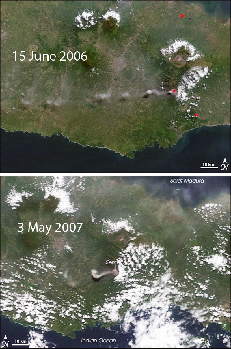 |
Figure 21. Two NASA-EO satellite images from MODIS on 15 June 2006 and 3 May 2007 show the often pulsing nature of ash emissions from Semeru. The discrete puffs can maintain their integrity for tens of kilometers from the volcano. Prevailing winds most commonly send ash to the W. Courtesy of NASA-EO. |
Activity during January 2009-July 2012. The style of activity changed during 2009. MODVOLC recorded only a single thermal alert pixel on 2 January 2009, and nothing after that until August 2009. PVMBG maintains a four-level Volcano Alert system; Level 1 (Normal) is the lowest, followed by Level II (Alert), Level III (Standby), and Level IV (Beware). They reported that typical activity during Alert Level II ("Alert") conditions were ash eruptions at 20-30 minute intervals with plumes rising 100-400 m from the summit. They noted a loud explosion on 8 February 2009, and another on 6 March that was accompanied by lightning. The 6 March event led PVMBG to increase the Alert Level to III (Standby) in their 6 March 2009 report. This activity was followed a few days later by an ash eruption, reported by the Darwin VAAC, with a plume that rose to 4.6 km altitude. After another ash emission on 15 March that rose 600 m above the crater, ash emissions "gradually disappeared" and seismicity decreased, according to a 17 July 2009 report from PVMBG; the Alert Level was then lowered back to II.
A single MODVOLC thermal alert pixel was recorded on the NW flank on 8 August 2009. In their next report in March 2010, PVMBG noted that from November 2009 through February 2010 visibility was generally poor due to weather, but there were occasional undescribed emissions that rose 50-500 m above the summit. They reported that the pattern of activity between April 2009 and 1 March 2010 changed from being dominated by ash eruptions to regular low-level emissions.
Incandescence from the summit on 5 January 2010 was followed by a MODVOLC thermal alert on 21 January. PVMBG reported a new lava flow on 25 February, which by 28 February had traveled 750 m. Rock avalanches from lava flows were reported during February (BGVN 35:08), September, and November 2010 (BGVN 37:04). Thermal alerts increased in number during April and May, before tapering off and ending on 28 November 2010. In their 4 November report PVMBG kept the Alert Level at II but noted an increase in lava-dome growth at the summit. Ash plumes were also observed by the Darwin VAAC rising to 4.6 km and drifting 75-110 km N and NW during 18-19 November.
No activity was reported between 29 November 2010 and 13 May 2011. Evidence for activity beginning again in May comes from a report by Volcano Discovery of 2-3 small ash eruptions per day during 13- 17 May (figure 22). MODVOLC thermal alert pixels reappeared on 2 June and were also noted on 15 June and 1 July. PVMBG reported eruptions of pyroclastic material on 9, 14, and 17 June. Volcano Discovery reported a growing lava dome on 1 September with 3-4 ash explosions per day during the first two weeks of September. MODVOLC thermal alerts were recorded on 5 and 7 October. PVMBG noted that seismicity had increased beginning on 29 December 2011, which was accompanied by dense white-and-gray plumes rising to 600 m above the Jonggring Seloko crater; a 300-m-long lava flow was also observed that day.
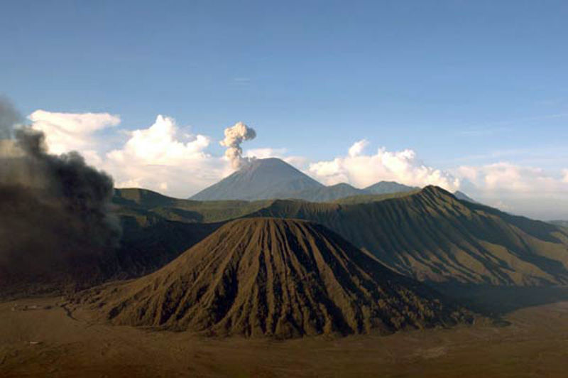 |
Figure 22. A view to the south of Semeru on the morning of 13 May 2011 from the Bromo-Tennger volcanic complex located 18 km N. The Bromo cone to the left is also producing an emission; Batok is in the middle foreground. Courtesy of Andi Rosati/Volcano Discovery. |
Dense gray-white plumes rose 600 m and preceded an explosion on 6 January 2012; the explosion was followed by summit incandescence. Repeated observations of incandescent material flowing up to 400 m SE toward the Besuk Kembar drainage were made during the rest of January. On 2 February, just after midnight, a pyroclastic flow traveled 300 m from the Jongring Seloko crater, and by mid-morning it had traveled farther, to 2.5 km from the crater. This led PVMBG to raise the Alert Level to III that day, prohibiting people from an area on the SE slopes within 4 km of the crater (BGVN 37:04).
Numerous MODVOLC thermal alert pixels were recorded between 30 January and 21 April 2012, and a final pixel recorded on 9 May 2012. PVMBG noted that several pyroclastic flows had occurred during February, and incandescence at the summit was common through the end of March. During April, white plumes rose 500 m above the summit, seismicity decreased, and no incandescence was observed. Based on this, PVMBG lowered the Alert Level to II on 2 May 2012. A Google Earth image of the volcano taken a few weeks later on 21 May 2012 shows a clear view of the summit crater with the lava dome visible (figure 23). Volcano Discovery reported that on an expedition during 18-19 July they observed slow lava dome growth, with an incandescent area at the SW part of the dome producing small to moderate ash explosions. There were no reports of ash plumes from the Darwin VAAC during 2012.
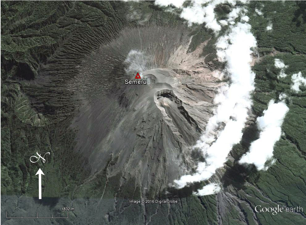 |
Figure 23. DigitalGlobe satellite image of Semeru captured on 21 May 2012 with a clear view of the lava dome inside the Jonggring Seloko summit crater. Slow moving lava flows from the dome traveled down the ravine on the S flank. Courtesy of Google Earth. |
Activity during June 2013-December 2015. After the 19 July 2012 update from Volcano Discovery, there was no evidence for activity at Semeru until a MODVOLC thermal alert pixel appeared on 4 June 2013, followed by four more in June and one on 7 July. No reports were issued by PVMBG during 2013. The Darwin VAAC issued a report on 18 October 2013 that a low-level ash plume had been observed, but was not visible on satellite imagery. A single MODVOLC pixel was recorded on 29 November.
The volcano was quiet again from 29 November 2013 until April 2014. PVMBG reported white-and-gray plumes drifting W from the summit 22 times during March 2014, and 21 times during April, at heights between 100 and 400 m from the summit. They also reported eight explosions during April with gray-to-white emissions rising 300-500 m and drifting W. Incandescent material was reported on 26 and 27 April, with rock avalanches sliding 300 m S from the summit. Strong multi-pixel MODVOLC alerts were recorded beginning on 5 June 2014 and continued for the rest of the year, although there were no further reports from PVMBG or the Darwin VAAC. The thermal anomalies were likely due to the growth of the lava dome. Volcano Discovery reported a lava flow from the dome in July 2014, noting that it extended a few hundred meters down Kembar ravine on the S flank in early September, when they also observed Strombolian activity in the summit crater (figure 24). They reported in November 2014 that the lava dome had a diameter of 100-200 m, and Strombolian activity ejected bombs up to 100 m above the vent (figure 25).
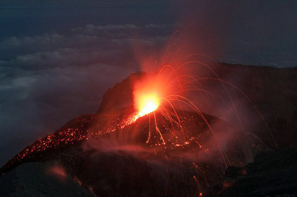 |
Figure 24. Strombolian activity in the summit crater at Semeru in mid-September 2014. Courtesy of Andi/Volcano Discovery. |
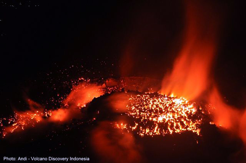 |
Figure 25. The active lava dome at Semeru in late November 2014. Courtesy of Andi/Volcano Discovery. |
Multiple MODVOLC thermal alert pixels were recorded every month during 2015. Although the volcano was very active during January-March 2015, PVMBG did not raise the Alert Level. Steam plumes rising 200-300 m above the crater were reported almost daily; explosions with gray-white plumes rising to heights of 200-500 m happened several times a week. In January, incandescent material traveled as far as 300 m down the Kembar ravine. In early March a trace amount of ash was deposited at a monitoring post near the summit after one explosion. During April 2015, ash plumes rose 200-600 m above the crater 68 times according to PVMBG; minor ashfall was reported on the flanks, and explosions were heard 30 times.
Activity increased further in May 2015, with ash plumes reported 122 times, rising 200-500 m above the summit and drifting W, NW, and SW. Incandescent rock avalanches descended as far as 1 km in the Kembar ravine. During June and July, ash emissions continued at the rate of a few per day, rising to 500 m above the summit (figure 26).
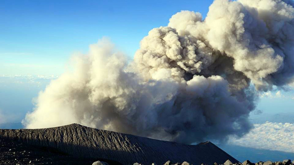 |
Figure 26. Ash emission at Semeru on 11 June 2015. Courtesy of Aris Yanto and Volcano Discovery. |
During August 2015 ash events were reported 47 times, with plumes rising 100-600 m above the summit and drifting S. Rock avalanches were reported twice travelling 500 m down the S flank. By September, explosions with white-and-gray plumes had decreased to 45 for the month. They caused the plumes to rise 100-500 m above the summit and drift W and N. Thirty-two explosions occurred during October producing gray-to-white plumes that rose 200-500 m and drifted W. Incandescent material was observed nine times in November and traveled as far as 500 m down the S flank. Also in November, Volcano Discovery reported continuous degassing and minor explosions from the lava dome (figure 27). Strombolian activity was observed five times in December by PVMBG. Dense gray-to-white ash plumes occurred eight times during November and 20 times in December, rising 100-500 m and drifting W.
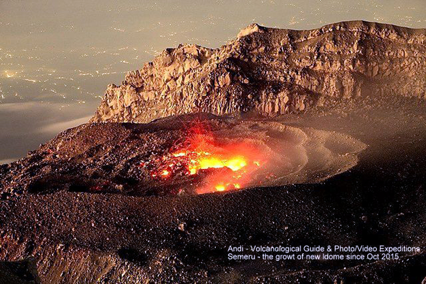 |
Figure 27. Active vent on the lava dome inside Semeru's summit crater in early November 2015. Courtesy of Andi/ Volcano Discovery. |
Activity during 2016-March 2017. Twenty-one ash explosions were reported in January 2016, with low-level plumes rising to 500 m and drifting E, N, and W. Although activity during 2016 began similarly to 2015, the character of the eruption changed during February. Beginning in mid-February, larger ash plumes triggered a series of VAAC reports, the first in many years. Multiple MODVOLC thermal alert pixels were also captured through the end of July 2016, with another one on 24 August and 19 November, suggesting continued growth of the lava dome and intermittent lava.
The Darwin VAAC reported ash plumes five times in 2016, on 13 February, 17 April (UTC), 25 and 27 May, and 10 June. The 13 February plume rose 7.9 km (4.3 km above the summit) and drifted 45 km NE. A local news source, Tempo Nasional, also reported a pyroclastic flow the same day that traveled 4-5 km down the S and SE flanks (figure 28).
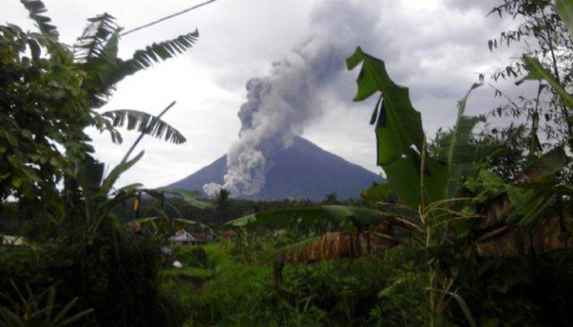 |
Figure 28. Pyroclastic flow from Semeru on 13 February 2016. Courtesy of David P, Tempo Nasional. |
The 18 April 2016 ash plume rose to 4.3 km altitude and drifted 40 km NE. Plumes on 25 and 27 May also rose to 4.3 km but drifted 25-40 km SW. On 10 June another plume rose 3.7 km and drifted 25 km SW. Volcano Discovery observed mild Strombolian activity from the crater on 26 July, and noted that the lava flow in the southern ravine was inactive. On another visit in late September the lava flow was incandescent 1,500 m down the ravine (figure 29). The MODVOLC thermal alert pixel from 19 November suggested that the lava dome remained active.
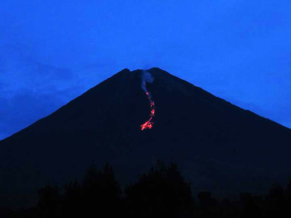 |
Figure 29. The incandescent lava flow in the ravine on the S slope of Semeru on 25 September 2016. View looking north. Courtesy of Aravind P./VolcanoDiscovery. |
A report from the Darwin VAAC on 9 January 2017 noted that an ash plume rose 3.9 km altitude that drifted N. A decrease in thermal activity is clear in the MIROVA thermal anomaly data for late March 2016 through late March 2017. Volcanic Radiative Power (VRP) values during April through June 2016 were in the Moderate range; they decreased in intensity (and frequency) to the Low range between July and December, and decreased again in both intensity and frequency after December 2016 (figure 30).
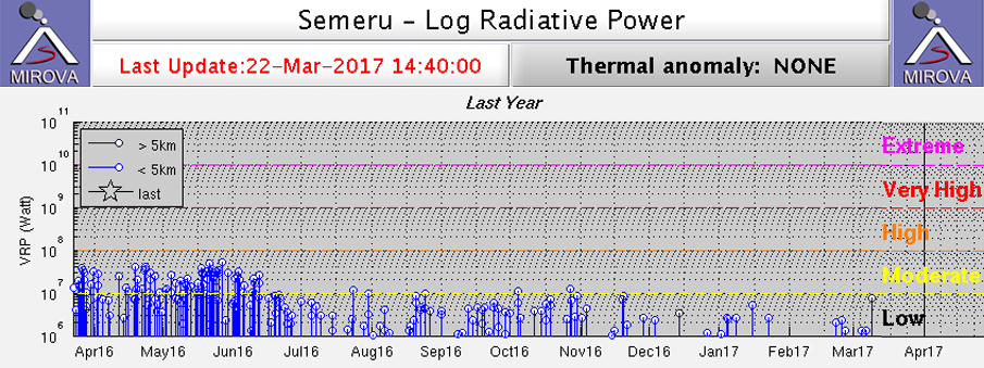 |
Figure 30. MIROVA thermal anomaly data for Semeru between 22 March 2016 and 22 March 2017. Volcanic Radiative Power (VRP) values during April through June 2016 were abundant and in the Moderate intensity range of 107-108 Watts; they decreased in intensity (and frequency) to slightly below 107 W between July and December, and decreased again in both intensity and frequency after December 2016. Courtesy of MIROVA. |
Geological Summary. Semeru, the highest volcano on Java, and one of its most active, lies at the southern end of a volcanic massif extending north to the Tengger caldera. The steep-sided volcano, also referred to as Mahameru (Great Mountain), rises above coastal plains to the south. Gunung Semeru was constructed south of the overlapping Ajek-ajek and Jambangan calderas. A line of lake-filled maars was constructed along a N-S trend cutting through the summit, and cinder cones and lava domes occupy the eastern and NE flanks. Summit topography is complicated by the shifting of craters from NW to SE. Frequent 19th and 20th century eruptions were dominated by small-to-moderate explosions from the summit crater, with occasional lava flows and larger explosive eruptions accompanied by pyroclastic flows that have reached the lower flanks of the volcano.
Information Contacts: Pusat Vulkanologi dan Mitigasi Bencana Geologi (PVMBG, also known as Indonesian Center for Volcanology and Geological Hazard Mitigation, CVGHM), Jalan Diponegoro 57, Bandung 40122, Indonesia (URL: http://www.vsi.esdm.go.id/); Darwin Volcanic Ash Advisory Centre (VAAC), Bureau of Meteorology, Northern Territory Regional Office, PO Box 40050, Casuarina, NT 0811, Australia (URL: http://www.bom.gov.au/info/vaac/); Hawai'i Institute of Geophysics and Planetology (HIGP), MODVOLC Thermal Alerts System, School of Ocean and Earth Science and Technology (SOEST), Univ. of Hawai'i, 2525 Correa Road, Honolulu, HI 96822, USA (URL: http://modis.higp.hawaii.edu/); Volcano Discovery, https://www.volcanodiscovery.com; MIROVA (Middle InfraRed Observation of Volcanic Activity), a collaborative project between the Universities of Turin and Florence (Italy) supported by the Centre for Volcanic Risk of the Italian Civil Protection Department (URL: http://www.mirovaweb.it/); Tempo Nasional, https://nasional.tempo.co, https://nasional.tempo.co/read/news/2016/02/14/058744712/ini-yang-jadi-penyebab-guguran-awan-panas-di-gunung-semeru.