Report on Tungurahua (Ecuador) — December 2017

Bulletin of the Global Volcanism Network, vol. 42, no. 12 (December 2017)
Managing Editor: Edward Venzke.
Edited by A. Elizabeth Crafford.
Tungurahua (Ecuador) Nearly constant ash emissions and frequent lahars during July-December 2015
Please cite this report as:
Global Volcanism Program, 2017. Report on Tungurahua (Ecuador) (Crafford, A.E., and Venzke, E., eds.). Bulletin of the Global Volcanism Network, 42:12. Smithsonian Institution. https://doi.org/10.5479/si.GVP.BGVN201712-352080
Tungurahua
Ecuador
1.467°S, 78.442°W; summit elev. 5023 m
All times are local (unless otherwise noted)
Eight distinct episodes of activity occurred at Ecuador's Tungurahua from November 2011 through December 2014 that included 10-km-high ash plumes, Strombolian activity, pyroclastic flows, lahars and a lava flow (BGVN 42:05). Another distinct eruptive episode, during April and May 2015, consisted primarily of persistent ash emissions (BGVN 42:08). Abundant rainfall during the first half of 2015 led to numerous lahars, some of which disrupted travel on local roads. Continuing activity from July through December 2015 is described below based on information provided by the Observatorio del Volcán Tungurahua (OVT) of the Instituto Geofísico (IG-EPN) of Ecuador, and aviation alerts from the Washington Volcanic Ash Advisory Center (VAAC).
After the last ash emissions reported in mid-May 2015, only minor emissions of steam with no ash rising to 500 m above the crater were reported during June. However, activity increased again during July, when ashfall was reported nearly every day at the lookout stations around Tungurahua, and several larger explosions produced ash plumes that rose as high as 7.5 km altitude, about 2.5 km above the summit. Frequent rains during July resulted in lahars in six different drainages. Multiple explosions during August caused ash plumes and ashfall in communities within 20 km several times every week with the highest plume rising to 8.5 km altitude. A similar pattern continued during September 2015, with longer periods of seismic tremor, persistent ash emissions, and Strombolian activity that sent block avalanches down the flanks. The number and intensity of explosions increased in October; multiple explosions every week resulted in ashfall in communities within 25 km, mostly to the NW, and low-energy Strombolian activity persisted throughout the month. The strongest explosions of the period began with a series of seismic tremors on 10 November that persisted for nine days; daily ash plumes rose to between 7 and 8 km altitude, with the highest plume reported rising to at least 9.1 km altitude. Several millimeters of ashfall were reported in the nearby communities and at lookout stations, and the ash plume was recognized in satellite data more than 250 km from the summit before dissipating. Activity tapered off by the end of November, and only weak steam emissions were reported during December 2015.
Activity during July-September 2015. Persistent steam plumes in July rose up to 500 m above the summit crater and drifted generally W, often carrying small quantities of ash. Several lookout stations in communities located within 20 km NW and SW reported ashfall almost every day, including Choglontús (13 km WSW), Bilbao, and El Manzano (8 km SW). Other stations that reported ashfall during the month included Palitahua, Mocha, Chacauco, and Pillate. IG-EPN reported explosions with larger ash plumes on 3, 12, and 14 July that rose as high as 7.5 km (figure 86). Increased seismicity on 21 and 22 July was associated with emissions that caused ashfall in most of the reporting locations.
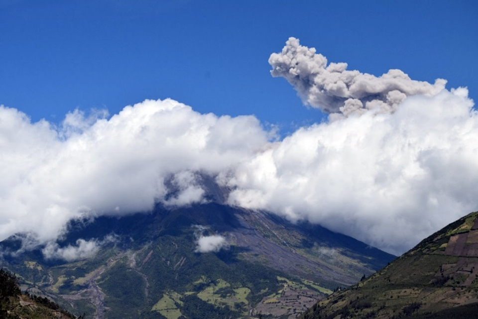 |
Figure 86. An ash plume rises 1 km above the summit crater at Tungurahua on 3 July 2015. Courtesy of OVT, IG-EPN, photo by P. Espin (Informe No. 802, Síntesis seminal del estado del Volcán Tungurahua, Semana: Del 30 de junio al 07 de julio de 2015). |
The Washington VAAC reported the ash plume on 3 July extending 25 km WSW from the summit at 5.2 km altitude (200 m above the crater); they also detected a faint hotspot in satellite imagery. They reported an ash plume extending 35 km WSW late in the day at 6.4 km on 14 July visible in satellite imagery (figure 87). An ash plume reported by the Washington VAAC on 31 July was moving SW at 6.7 km altitude.
 |
Figure 87. One of several explosions on 14 July 2015 at Tungurahua created an ash plume that rose at least 2 km above the summit and drifted W. Courtesy of OVT, IG-EPN, photo by F. Vasconez (Informe No. 803, Síntesis seminal del estado del Volcán Tungurahua, Semana: Del 07 de julio al 14 de julio de 2015). |
Lahars were reported during 5-7, 18-19, 22-23, and 29-30 July in the Chontapamba, Rea, Achupashal, Juive, Pondoa and Puela river drainages. Heavy rain on 18 and 19 July generated mudflows in the Juive, Pondoa and La Pampa ravines. Blocks 40 cm in diameter were reported in the Puela River on 22 July, and blocks 1 meter in diameter were reported in the Chontapamba river on 29 July.
There were fewer events with ash emissions during August compared to July. A lahar sent 40-cm-diameter blocks down the Mapayacu ravine on 14 August. Two explosions on 15-16 August caused ashfall in Choglontus, Manzano, and Chontapamba. Small lahars from the Rea and Romero drainages blocked the Baños-Penipe road on 16 August. An explosion on 18 August sent an ash plume WSW and caused ashfall in Choglontus; the next day reddish ash and steam emissions around 1000 local time caused ashfall again in Choglontus. Black ashfall was reported there on 22 August. Increased seismic activity with several explosions on 25 August was accompanied by ash plumes that caused ashfall in Chontapamba, Pillate, Bilbao, and Juive Grande. Gray ash was reported in Chinchicoto and Yanayacu, and thick black ash was reported in Rumipamba, Pingili and Mocha. Fine-grained gray ash was reported in Mocha on 27 August.
The Washington VAAC reported occasional emissions of gas and minor volcanic ash on 1 August 2015. A pilot report of an ash plume rising to 7 km altitude and drifting W on 15 August was not detected in satellite imagery due to weather clouds, although ashfall was reported within 15 km of the summit. Another pilot report on 20 August noted an ash plume to 8.5 km altitude. The altitude of an ash plume spotted drifting W on 25 August was estimated to be between 7.6 and 9 km. Ongoing emission of gas and possible minor ash was reported on 30 August at 6.7 km altitude moving W; the faint plume later detected in satellite imagery was moving WNW and extended about 50 km from the summit.
Mudflows from substantial rain on 1 and 7 September 2015 affected the Achupashal ravine and again disrupted travel on the Baños-Penipe road (figure 88). An ash plume on 2 September reached 3 km above the crater and drifted NW, causing ashfall in Pillate, Quero, Santuario, La Galera and El Rosario. Asfall was reported the next day in El Manzano and Choglontus. The Washington VAAC reported the ash plume at 8 km altitude on 2 September; the satellite imagery showed it extending 15 km WNW.
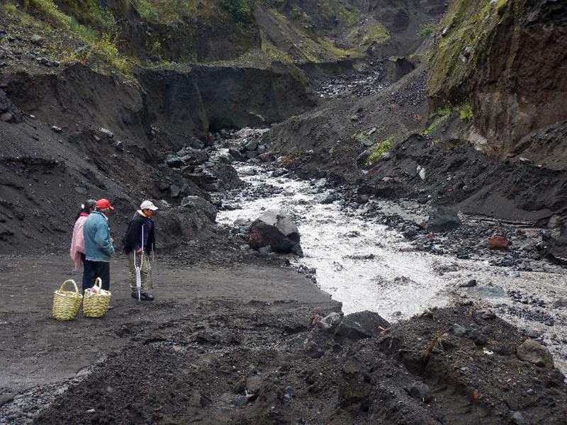 |
Figure 88. The Baños-Penipe road is frequently damaged by lahars in the Quebrada de Achupashal at Tungurahua, making travel difficult. The muddy water on 7 September 2015 washed out the road again. Courtesy of OVT, IG-EPN, photo by B. Bernard at 1359 local time (Informe No. 811, Síntesis seminal del estado del Volcán Tungurahua, Semana: Del 01 de septiembre de 2015 al 08 de septiembre). |
Moderate to high amounts of ash characterized the emissions on 11 September 2015 (figure 89). The plumes rose 2 km above the crater, drifted W and caused slight ashfall in Chonglontus and El Manzano. Only Chonglontus reported additional ashfall the next day. The Washington VAAC initially reported the ash plume at 7.3 km altitude extending 40 km SW on 11 September. About 6 hours later, the leading edge of the plume was dissipating about 170 km SW. This was followed by a new ash plume late in the day that rose to 5.8 km altitude and drifted 15 km WSW from the summit. Slight incandescence was reported on 13 September along with minor ash and steam emissions that were moving W at 7.6 km altitude.
 |
Figure 89. An ash plume drifts W from Tungurahua on 11 September 2015. Courtesy of OVT, IG-EPN, photo by S. Santamaria (Informe No. 811, Síntesis seminal del estado del Volcán Tungurahua, Semana: Del 08 de septiembre de 2015 al 15 de septiembre). |
Constant emission of moderate amounts of ash on 19 September 2015 created an ash plume that rose to 2 km above the crater and drifted NW. Ashfall was reported in El Manzano and Pillate. An explosion late in the day rattled structures in Pondoa, and was followed by observations of incandescence at the crater shortly after midnight. Ashfall was reported to the W in Pillate, El Manzano, Bilbao, Motilones, Chontapamba, and Choglontus the following day. Ongoing emissions were not visible in satellite imagery due to weather clouds. A sudden deflation in the deformation data was recorded on 19 September. Similar deflation events preceded major explosions in July 2013 and February 2014.
Several hours of seismic tremor on 27 September produced an ash-rich plume and incandescent blocks which descended the W flank. This was followed by additional explosions and periods of tremor, some lasting for more than an hour (figure 90), that produced ash plumes drifting SW. Ashfall was reported in the towns of Manzano, Choglontus, Cahuají, and Palictahua. Additional ashfall was reported the next day in Choglontus and Manzano. The Washington VAAC spotted a faint ash plume moving W in multispectral imagery on 27 September, and another plume at 6.7 km altitude moving slowly NW the next day around noon. New fumaroles not previously observed below the W flank of the crater were observed on 29 September for the first time.
 |
Figure 90. Lengthy tremors that registered at the seismic station RETU coincided with ash-rich plumes and incandescent blocks at Tungurahua between midnight and noon local time on 27 September 2015. Courtesy of OVT, IG-EPN (Informe No. 814, Síntesis seminal del estado del Volcán Tungurahua, Semana: Del 22 al 29 de septiembre de 2015). |
Activity during October-December 2015. Tremors were followed by a significant explosion on 4 October 2015 that produced ash emissions and block avalanches that traveled down the W flank. Ashfall reports were issued from the communities of Manzano, Choglontus, and Cahuají, all located to the SW. The Washington VAAC reported the ash plume 35 km WSW of the summit at 9.1 km altitude. Seismic activity increased beginning on 8 October. On 11 October, four explosions produced Strombolian-style activity with incandescent blocks traveling down the Chomtapamba and Achupashal ravines, an ash plume rising 2 km above the crater, and ashfall in regions to the NW and SW including Manzano, Choglontus, Puela and Mocha. The Washington VAAC reported the ash plume extending W from the summit at 7.9 km altitude. Around 2000 local time, the ash plume resembled a large mushroom cloud, and loud noises were reported from Cusua. There were numerous reports of incandescent blocks and explosions heard on the N and E flanks during the evening and overnight into the next morning (figure 91). Ashfall was again reported in Choglontus on 13 October.
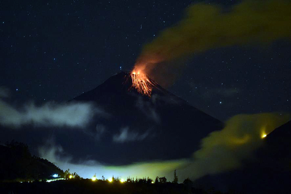 |
Figure 91. Incandescent blocks descend the upper flank of Tungurahua at 1909 local time on 11 October 2015. Courtesy of OVT, IG-EPN, photo by E. Telenchana (Informe No. 816, Síntesis seminal del estado del Volcán Tungurahua, Semana: Del 06 al 13 de octubre de 2015). |
An explosion in the early morning hours of 14 October was heard at all of the stations around the volcano. It was followed by ashfall in Choglontus. An ash emission on 19 October rose 1 km above the crater and drifted W and SW, producing ashfall in Choglontus, Bilbao, Pillate, and Cotaló. The Washington VAAC reported the plume extending 55 km NW of the summit at 6.7 km altitude. The next day, ongoing seismic data suggested frequent diffuse ash emissions. A plume was detected in multispectral data at 7.6 km altitude radiating E and rapidly dissipating. That afternoon (20 October), ashfall was reported in the Punzupala area. Ashfall continued from daily emissions for the next week with the most ashfall reported from Manzano, Choglontus, Bilbao, and Chacauco. Communities with trace amounts of ashfall included Ambato, Quero, Cevallos, Huachi, Chiquicha, Huambaló, Cotaló, and Pillate.
Incandescent material was observed traveling more than 1,000 m down the W flank from an explosion on 25 October. Local television reported ashfall in Ambato, Cevallos, Quero, and parts of Mocha and Tisaleo later that day. Swarms of LP earthquakes followed by episodes of ash emissions and low-energy Strombolian activity continued for the remainder of the month and into early November, causing sporadic ashfall in nearby villages. A small lahar was reported in the La Pampa ravine on 30 October.
An emission on 2 November 2015 created an ash plume that rose about 1.5 km above the crater and drifted E and NE; small quantities of ash were reported in the upper Runtun area. Incandescence at the summit crater from Strombolian activity was observed that night and for several days following. Heavy rains on 7 November caused mudflows in the Romero, Pingullo, and Achupashal ravines, and a larger lahar with meter-size blocks in the Chontapamba ravine. The Washington VAAC noted a dark emission from the volcano drifting W on 8 November at 5.5 km altitude.
A new series of tremors beginning on 10 November, coincided with more than a week of continuous ash emissions which reached 3.5 km above the crater and drifted in several directions. Incandescence was observed at night, and incandescent blocks descended generally up to 500 m down the NW, N, and E flanks during this period (figure 92).The Washington VAAC first reported an ash plume at 7.6 km altitude late in the evening on 10 November and continued with a constant series of reports for the next nine days. Most of the plumes were reported between 7 and 8 km altitude, drifting generally W (figure 93). The ash plumes produced heavy black ashfall in Manzano, Choglontus, Bilbao, Mocha, Quero, Cotaló, Tisaleo, Penipe and Cevallos. An ash plume was visible about 130 km W by midday on 11 November, and the plume had reached 8.2 km altitude. Loud noises were reported numerous times from the nearby communities for several days. On 12 November the Washington VAAC reported volcanic ash observed in satellite data extending 200 km WNW at 9.1 km altitude. Ashfall was heavy enough on 14 November to cause tree branches near Choglontus to bend under the weight of the ash.
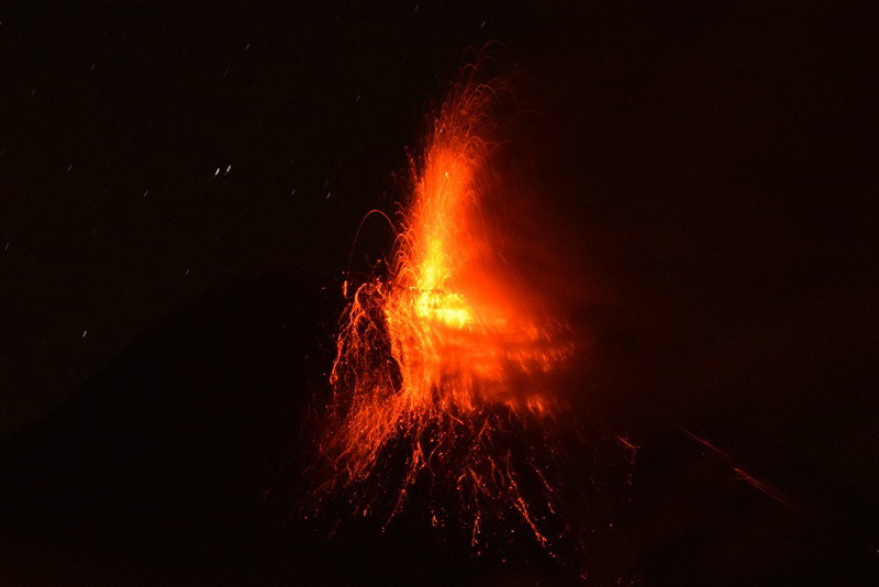 |
Figure 92. Strombolian activity from the summit of Tungurahua causes incandescent blocks to fall 500 m down the flanks of on 14 November 2015. Courtesy of OVT, IG-EPN, photo by V. Valverde (Informe No. 821, Síntesis seminal del estado del Volcán Tungurahua, Semana: 10 al 17 de noviembre de 2015). |
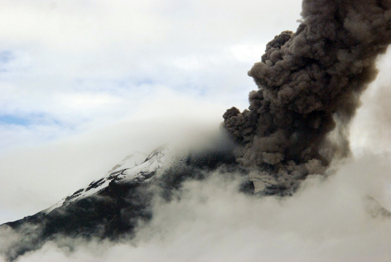 |
Figure 93. A dense ash plume rises from the summit of Tungurahua and drifts W on 17 November 2015. A small pyroclastic flow is visible on the NW flank (right side of image). Courtesy of OVT, IG-EPN, photo by S. Santamaria (Informe No. 822, Síntesis seminal del estado del Volcán Tungurahua, Semana: 17 al 24 de noviembre de 2015). |
A plume on 15 November 2015 rose more than 5 km above the crater (10 km altitude), according to IG-EPN, and sent blocks about 1,000 m down the flanks. On 18 November, the Washington VAAC reported a narrowing plume extending 270 km W from the summit. The largest ashfalls occurred during the night of 18-19 November. Strombolian activity sent blocks 800 m down the flanks during the night, and a strong "jet" was observed in the eastern part of the crater. Incandescent material was observed from two eruptive vents late on 18 November. Five millimeters of ash were reported from the solar panels at the Tablor station on 19 November, deposited in less than 24 hours (figure 94). IG-EPN reported this event as one of the most significant ashfall events since 2010; many crops and livestock animals were affected. Dense ash emissions tapered off after 19 November, and smaller, less dense plumes rose 2 km above the crater on 22-23 November. The University of Hawaii's MODVOLC system issued thermal alerts for Tungurahua on 15 (2) and 19 (3) November, the only time during 2015. Significant sulfur dioxide (SO2) emissions were captured by the OMI instrument on the Aura Satellite during the mid-November episode from 11-19 November (figure 95).
 |
Figure 94. A 5-mm thick layer of ash was deposited on the solar panels of the Tablon station at Tungurahua in less that 24 hours on 19 November 2015. Courtesy of OVT, IG-EPN, photo by S. Santamaria (Informe No. 822, Síntesis seminal del estado del Volcán Tungurahua, Semana: 17 al 24 de noviembre de 2015). |
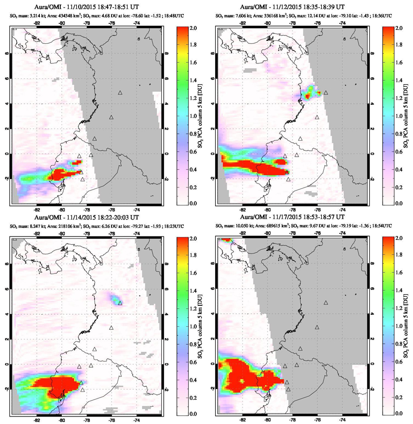 |
Figure 95. Substantial SO2 plumes originating from Tungurahua were recorded by the OMI instrument on the Aura satellite during 10-19 November 2015. Top left: the plume from Tungurahua drifts WSW while a smaller plume from Cotopaxi is visible about 90 km N on 10 November. Top right: the plume from Tungurahua drifts WNW on 12 November at the bottom of the image, a much smaller plume drifts W from Cotopaxi immediately above it, and a third SO2 plume is visible drifting WSW from Nevado del Ruiz in Colombia 750 km NNE. Lower left: a larger plume on 14 November drifts WSW from Tungurahua and probably includes some gas from Cotopaxi. Lower right: a large plume from Tungurahua disperses W on 17 November for well over 500 km. Courtesy of NASA Goddard Space Flight Center. |
A seismic swarm with 33-35 events per hour began on 25 November, and tapered off to 3-5 events per hour by 30 November 2015. There was no increase in surface activity during the swarm, but rather a gradual decrease, with no significant ashfall reported during the last week of November. Activity diminished significantly during December 2015. Weak steam emissions that reached no higher than 500 m above the crater were typical. Seismicity remained low, and there were no reports of ash emissions or ashfall in the area.
Geological Summary. Tungurahua, a steep-sided andesitic-dacitic stratovolcano that towers more than 3 km above its northern base, is one of Ecuador's most active volcanoes. Three major edifices have been sequentially constructed since the mid-Pleistocene over a basement of metamorphic rocks. Tungurahua II was built within the past 14,000 years following the collapse of the initial edifice. Tungurahua II collapsed about 3,000 years ago and produced a large debris-avalanche deposit to the west. The modern glacier-capped stratovolcano (Tungurahua III) was constructed within the landslide scarp. Historical eruptions have all originated from the summit crater, accompanied by strong explosions and sometimes by pyroclastic flows and lava flows that reached populated areas at the volcano's base. Prior to a long-term eruption beginning in 1999 that caused the temporary evacuation of the city of Baños at the foot of the volcano, the last major eruption had occurred from 1916 to 1918, although minor activity continued until 1925.
Information Contacts: Instituto Geofísico (IG), Escuela Politécnica Nacional, Casilla 17-01-2759, Quito, Ecuador (URL: http://www.igepn.edu.ec ); Washington Volcanic Ash Advisory Center (VAAC), Satellite Analysis Branch (SAB), NOAA/NESDIS OSPO, NOAA Science Center Room 401, 5200 Auth Rd, Camp Springs, MD 20746, USA (URL: www.ospo.noaa.gov/Products/atmosphere/vaac, archive at: http://www.ssd.noaa.gov/VAAC/archive.html); Hawai'i Institute of Geophysics and Planetology (HIGP) - MODVOLC Thermal Alerts System, School of Ocean and Earth Science and Technology (SOEST), Univ. of Hawai'i, 2525 Correa Road, Honolulu, HI 96822, USA (URL: http://modis.higp.hawaii.edu/); NASA Goddard Space Flight Center (NASA/GSFC), Global Sulfur Dioxide Monitoring Page, Atmospheric Chemistry and Dynamics Laboratory, 8800 Greenbelt Road, Goddard, Maryland, USA (URL: https://so2.gsfc.nasa.gov/).