Report on Langila (Papua New Guinea) — June 2018

Bulletin of the Global Volcanism Network, vol. 43, no. 6 (June 2018)
Managing Editor: Edward Venzke.
Research and preparation by Robert Andrews.
Langila (Papua New Guinea) Gradual decline in activity after July 2017, but continuing through May 2018
Please cite this report as:
Global Volcanism Program, 2018. Report on Langila (Papua New Guinea) (Venzke, E., ed.). Bulletin of the Global Volcanism Network, 43:6. Smithsonian Institution. https://doi.org/10.5479/si.GVP.BGVN201806-252010
Langila
Papua New Guinea
5.525°S, 148.42°E; summit elev. 1330 m
All times are local (unless otherwise noted)
Langila, one of the most active volcanoes of New Britain (figure 7), has been intermittently ejecting ash since April 2016 (BGVN 42:09). Volcanic ash warnings continue to be issued by the Darwin Volcanic Ash Advisory Centre (VAAC). Recent ash plume altitudes (table 5) are in the range of 1.5-2.5 km, but several in mid-April to mid-May 2018 reached up to twice that level. Thermal anomaly data acquired by satellite-based MODIS instruments showed a gradual decrease in power level and occurrence through mid- to late-2017, followed by significantly fewer alerts and anomalies in the first half of 2018. Rabaul Volcano Observatory (RVO) data indicates the activity during 2017 was primarily located in Crater 2 (northern-most crater).
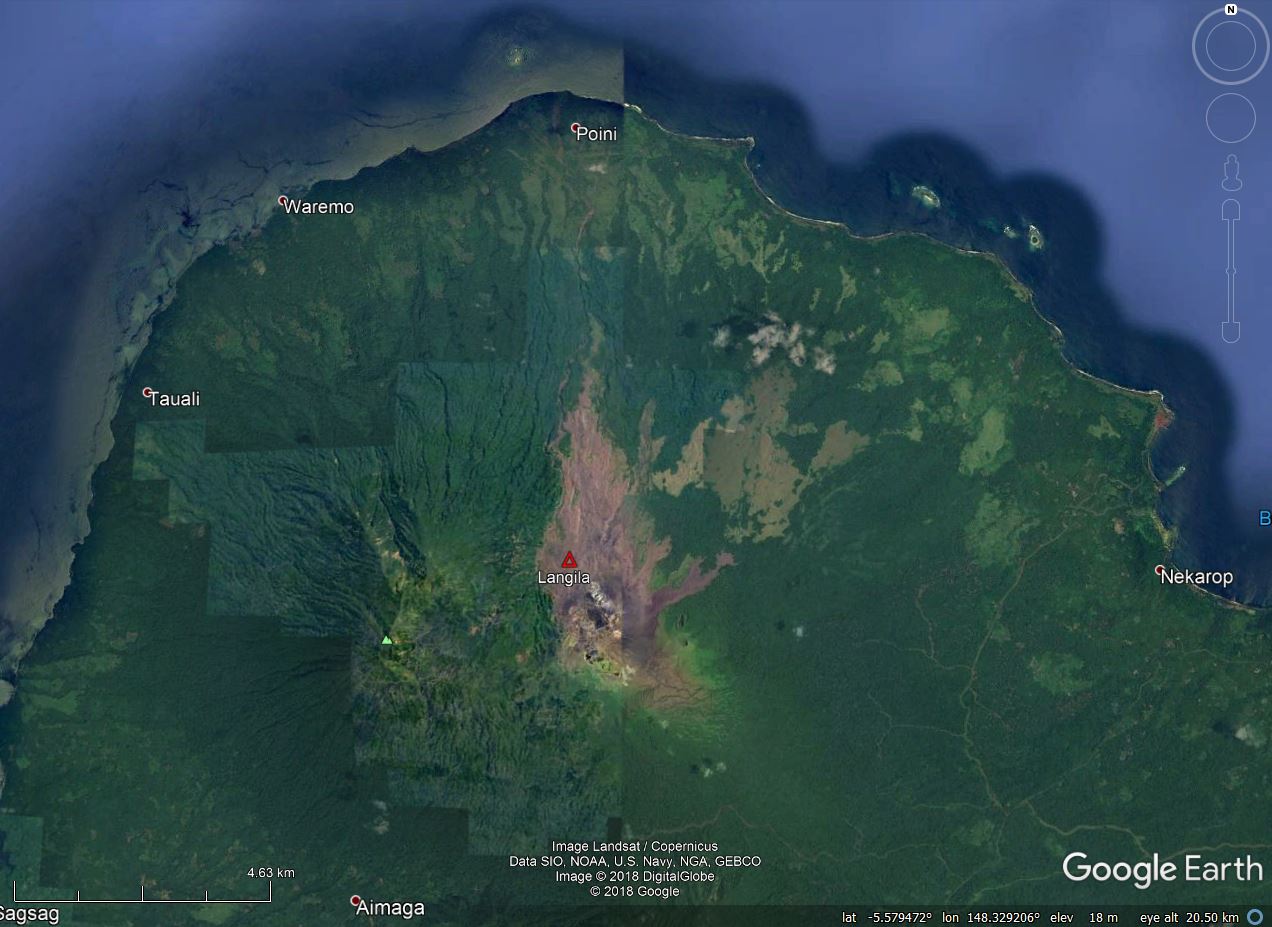 |
Figure 7. Satellite imagery showing Langila volcano at the far NW end of New Britain island. The brown color of recent lava flows and other volcanic deposits are easily noticeable compared to green vegetated areas. The volcano is about 9 km due south of the community labeled Poini. Imagery in this view is from sources listed on the image; courtesy of Google Earth. |
Table 5. Reported data by Darwin Volcanic Ash Advisory Centre (VAAC) on ash plume altitude and drift from Langila based on analyses of satellite imagery and wind model data between 21 June 2017 and 28 May 2018.
| Dates | Ash Plume Altitude (km) | Ash Plume Drift | Other Observations |
| 07 Aug 2017 | 2.1 | 55 km NW | -- |
| 09 Aug 2017 | 1.8 | N | -- |
| 16 Aug 2017 | 2.1 | NW | -- |
| 01-02 Sep 2017 | 1.8 | N, NW | -- |
| 07-08, 10-12 Sep 2017 | 1.8-2.4 | NNW, NW, SW | -- |
| 22-23 Sep 2017 | 2.1 | NNW | -- |
| 04 Oct 2017 | 1.8 | N | Minor ash emission |
| 11, 15-16 Oct 2017 | 1.8-2.1 | NE, NNW, NW | -- |
| 17-18, 20 Oct 2017 | 1.5-1.8 | NE, NNW, NW | -- |
| 05 Nov 2017 | 3.7 | SE, ESE | -- |
| 15-16 Nov 2017 | 1.8-2.7 | S, SW | -- |
| 15 Apr 2018 | 3.7 | S | -- |
| 24 Apr 2018 | 4 | SW | Ash dissipated in 6 hours |
| 13 May 2018 | 5.5 | W | At 0709; ash dissipated in 6 hours |
| 17-18, 21-22 May 2018 | 2.1-2.4 | WSW, W, WNW | -- |
| 23, 26-28 May 2018 | 2.4-3 | WSW, W, NW | -- |
MIROVA analysis of thermal anomalies measured by MODIS satellite sensors show a gradual decline of radiative power from early June 2017 to the end of the year (figure 8). Sporadic low-power anomalies occurred in January, April, and May 2018.
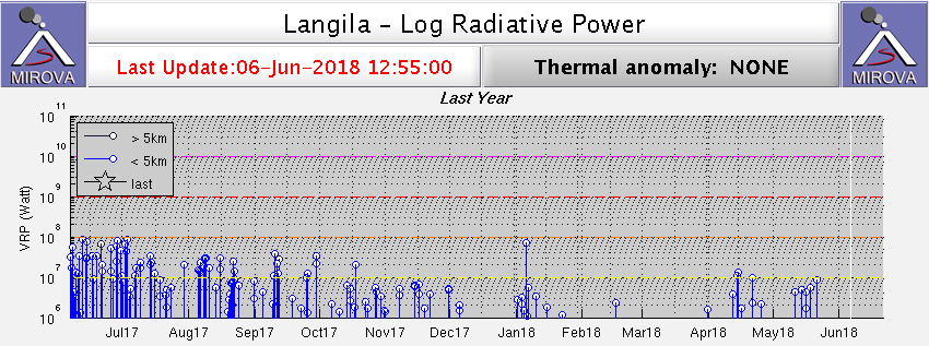 |
Figure 8. Thermal anomalies from MODIS data analyzed by MIROVA, plotted as log radiative power vs time for the year ending 6 June 2018. Courtesy of MIROVA. |
Thermal alerts from MODVOLC analyses were concentrated between early June 2017 and late September 2017 (figure 9), with only one pixel being measured in 2018 through early June, that alert being on 5 January 2018.
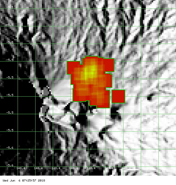 |
Figure 9. Map showing thermal anomalies from MODIS data analyzed by MODVOLC for the year ending 6 June 2018. Courtesy of HIGP - MODVOLC Thermal Alerts System. |
Geological Summary. Langila, one of the most active volcanoes of New Britain, consists of a group of four small overlapping composite basaltic-andesitic cones on the lower E flank of the extinct Talawe volcano in the Cape Gloucester area of NW New Britain. A rectangular, 2.5-km-long crater is breached widely to the SE; Langila was constructed NE of the breached crater of Talawe. An extensive lava field reaches the coast on the N and NE sides of Langila. Frequent mild-to-moderate explosive eruptions, sometimes accompanied by lava flows, have been recorded since the 19th century from three active craters at the summit. The youngest and smallest crater (no. 3 crater) was formed in 1960 and has a diameter of 150 m.
Information Contacts: Darwin Volcanic Ash Advisory Centre (VAAC), Bureau of Meteorology, Northern Territory Regional Office, PO Box 40050, Casuarina, NT 0811, Australia (URL: http://www.bom.gov.au/info/vaac/); Hawai'i Institute of Geophysics and Planetology (HIGP) - MODVOLC Thermal Alerts System, School of Ocean and Earth Science and Technology (SOEST), Univ. of Hawai'i, 2525 Correa Road, Honolulu, HI 96822, USA (URL: http://modis.higp.hawaii.edu/); MIROVA (Middle InfraRed Observation of Volcanic Activity), a collaborative project between the Universities of Turin and Florence (Italy) supported by the Centre for Volcanic Risk of the Italian Civil Protection Department (URL: http://www.mirovaweb.it/); Rabaul Volcano Observatory (RVO), Geohazards Management Division, Department of Mineral Policy and Geohazards Management (DMPGM), PO Box 3386, Kokopo, East New Britain Province, Papua New Guinea.