Report on Aira (Japan) — July 2018

Bulletin of the Global Volcanism Network, vol. 43, no. 7 (July 2018)
Managing Editor: Edward Venzke.
Edited by Janine B. Krippner.
Aira (Japan) Activity resumed in March 2017 and remained relatively low through the year
Please cite this report as:
Global Volcanism Program, 2018. Report on Aira (Japan) (Krippner, J.B., and Venzke, E., eds.). Bulletin of the Global Volcanism Network, 43:7. Smithsonian Institution. https://doi.org/10.5479/si.GVP.BGVN201807-282080
Aira
Japan
31.5772°N, 130.6589°E; summit elev. 1117 m
All times are local (unless otherwise noted)
Aira caldera encompasses the northern half of Kagoshima Bay in Kyushu, Japan. During the Holocene activity has been focused at Sakurajima volcano along the southern rim of the caldera, and more recent activity has occurred at the Minamidake and Showa summit craters (figure 59). Minamidake crater has been persistently active since 1955, and activity at Showa crater resumed in 2006. Sakurajima is one of Japan's most active volcanoes and frequently deposits ash over the nearby Kagoshima city. This report covers activity that occurred through 2017 and is based on reports issued by the Japan Meteorological Agency (JMA).
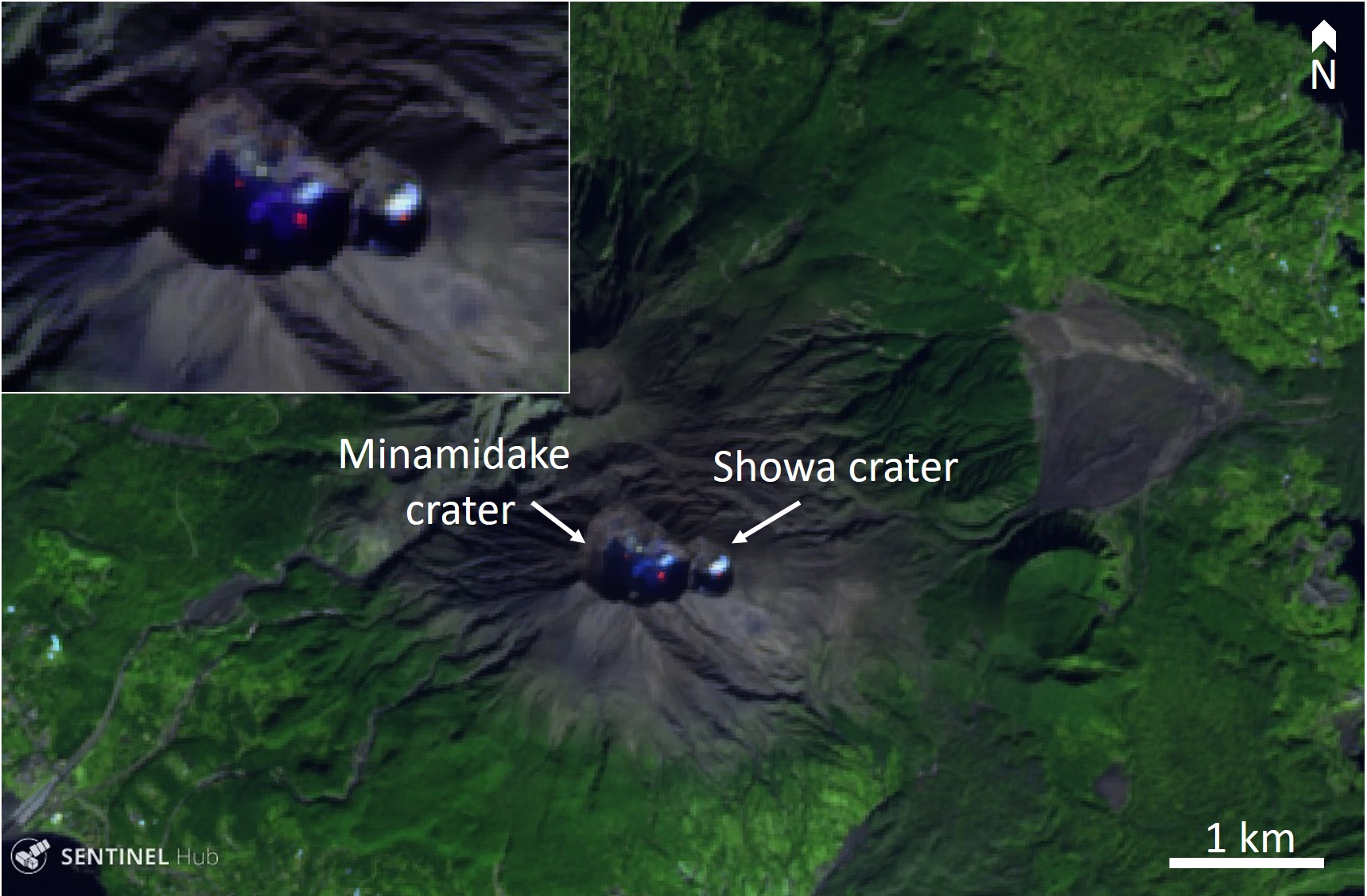 |
Figure 59. The active Minamidake and Showa craters of Sakurajima volcano at Aira. Three incandescent vents within the craters are visible in this Sentinel-2 false color thermal image (bands 12, 11, 4) that was acquired on 13 December 2017. Courtesy of Sentinel Hub Playground. |
Typical activity largely consists of Vulcanian explosions that produce ash plumes and small pyroclastic flows. Prior to a decrease in activity in August 2016, the volcano typically produced tens of explosions per month. The last recorded explosion in 2016 was a low-level ash plume on 22 August at 1.2 km altitude, reported by the Tokyo Volcanic Ash Advisory Center (VAAC). Sakurajima has remained on Activity Alert Level 3 (do not approach) on an alert level scale of 1 (little to no activity) to 5 (eruption or imminent eruption causing significant damage to residential areas).
Activity has been low since August 2016. No eruptions were observed through January and February 2017, and both seismicity and SO2 emission levels remained low.
Eruptive activity resumed on 25 March 2017 at 1803 local time, when the Minamidake crater produced an ash plume to 500 m above the crater and a pyroclastic flow travelled approximately 1,100 m to the south (figure 60). Several additional small ash emission events were noted after this event.
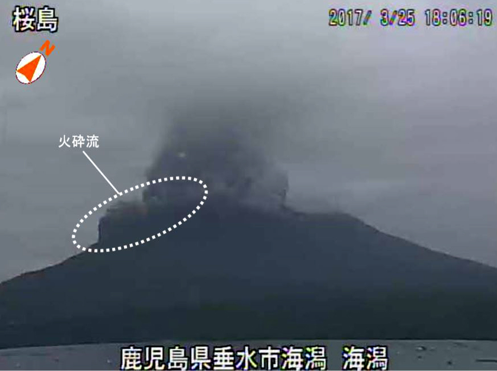 |
Figure 60. Eruption at the Minamidake crater of Sakurajima (Aira caldera) on 25 March 2017 at 1803 local time. The ash plume reached 500 m above the crater and a pyroclastic flow traveled 1,100 m to the south. Image taken by the Kaigata surveillance camera, courtesy of JMA (March 2017 Monthly Sakurajima report). |
Showa crater resumed activity at 0511 on 26 April 2017; 19 more events occurred through the month, including two larger explosive events. One explosive event produced an ash plume to 3,200 m above the crater on 28 April at 1101 local time. Two events occurred at the Minamidake crater through April.
Activity continued at the Showa crater in May, with 47 ash emission events, with nine of these being explosive events. One event on 2 May produced a 4,000-m-high plume that deposited ash on nearby communities (figure 61). Several larger explosions ejected blocks out to 500-800 m from the Showa crater. Activity continued at Minamidake crater, with ash reaching 2,500 m above the crater during an event on 5 May.
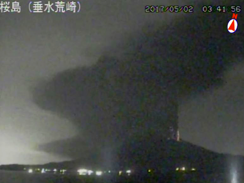 |
Figure 61. Eruption of Sakurajima in the Aira caldera on 2 May 2017 at 0320 local time. The ash plume reached 4,000 m above the crater. Image taken by the Tarumi Ararazaki surveillance camera, courtesy of JMA (May 2017 Monthly Sakurajima report). |
Through June, the Showa crater produced 14 events, including two explosive events. An explosion on 6 June produced an ash plume up to 3,200 m above the crater and blocks were deposited out to 800 m from the crater. One small event occurred at Minamidake. Activity was reduced in July, with seven events at Showa crater and none at Minamidake.
During August no events took place at Minamidake. However, Showa crater remained active with 98 events, including 20 that were explosive. Activity through September was similar with no activity in Minamidake crater and 170 events at Showa, including 38 explosive events.
Activity declined again from October through December. During October there were 37 events from Showa crater, with five being explosive (figure 62). One event at Minamidake crater on 31 October produced an ash plume up to 1,000 m above the crater. During November, five events occurred at Minamidake crater, and one at Showa crater that produced an ash plume to 1,300 m above the crater. In December, one event occurred at the Showa crater and Minamidake produced one small event.
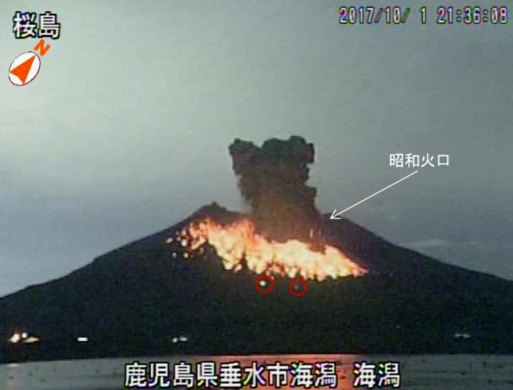 |
Figure 62. An explosive event is seen in this webcam image from the Sakurajima volcano Showa crater (Aira caldera) on 1 October, 2135 local time. Incandescent blocks were deposited out to 1,300 m from the crater. Image taken by the Tarumi Arasaki surveillance camera, courtesy of JMA (October 2017 Monthly Sakurajima report). |
Geological Summary. The Aira caldera in the northern half of Kagoshima Bay contains the post-caldera Sakurajima volcano, one of Japan's most active. Eruption of the voluminous Ito pyroclastic flow accompanied formation of the 17 x 23 km caldera about 22,000 years ago. The smaller Wakamiko caldera was formed during the early Holocene in the NE corner of the caldera, along with several post-caldera cones. The construction of Sakurajima began about 13,000 years ago on the southern rim and built an island that was joined to the Osumi Peninsula during the major explosive and effusive eruption of 1914. Activity at the Kitadake summit cone ended about 4,850 years ago, after which eruptions took place at Minamidake. Frequent eruptions since the 8th century have deposited ash on the city of Kagoshima, located across Kagoshima Bay only 8 km from the summit. The largest recorded eruption took place during 1471-76.
Information Contacts: Tokyo Volcanic Ash Advisory Center (VAAC), 1-3-4 Otemachi, Chiyoda-ku, Tokyo, Japan (URL: http://ds.data.jma.go.jp/svd/vaac/data/); Japan Meteorological Agency (JMA), Otemachi, 1-3-4, Chiyoda-ku Tokyo 100-8122, Japan (URL: http://www.jma.go.jp/jma/indexe.html); Sentinel Hub Playground (URL: https://www.sentinel-hub.com/explore/sentinel-playground).