Report on Alaid (Russia) — September 2018
Bulletin of the Global Volcanism Network, vol. 43, no. 9 (September 2018)
Managing Editor: Edward Venzke.
Research and preparation by Paul Berger.
Alaid (Russia) Small ash plume reported on 21 August 2018
Please cite this report as:
Global Volcanism Program, 2018. Report on Alaid (Russia) (Venzke, E., ed.). Bulletin of the Global Volcanism Network, 43:9. Smithsonian Institution. https://doi.org/10.5479/si.GVP.BGVN201809-290390
Alaid
Russia
50.861°N, 155.565°E; summit elev. 2285 m
All times are local (unless otherwise noted)
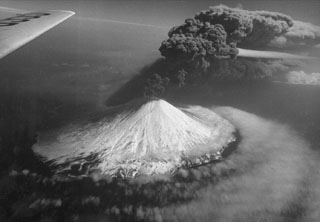
Sporadic ash and gas-and-ash plumes and strong thermal anomalies were reported from Alaid, in Russia's Kurile Islands, between 29 September 2015 and 30 September 2016 (figure 8). The Kamchatka Volcanic Eruptions Response Team (KVERT), which monitors the volcano, interpreted the thermal anomalies as Strombolian activity and a lava flow (BGVN 42:04). The current report summarizes activity during October 2016 through August 2018.
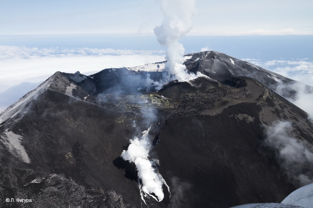 |
Figure 8. Aerial photo of the Alaid summit area on 28 April 2016, with fresh lava filling the crater, a cinder cone in the southern part of the crater, and a lava flow on the SW flank. Photo by L. Fugura; courtesy of IVS FEB RAS, KVERT. |
According to KVERT weekly reports, the Aviation Color Code for Alaid was Green (Volcano is in normal, non-eruptive state) throughout the reporting period. The only reported activity was from the Tokyo Volcanic Ash Advisory Center, which reported that on 21 August 2018, an ash plume identified in Himawari-8 satellite images rose to an altitude of 2.7 km (about 500 m above the summit) and drifted SE. The plume was clearly visible on imagery starting at 0830 Japan Standard Time (UTC + 9 hours), and remained noticeable for at least 4 hours. There were no other satellite or ground-based observations of this activity.
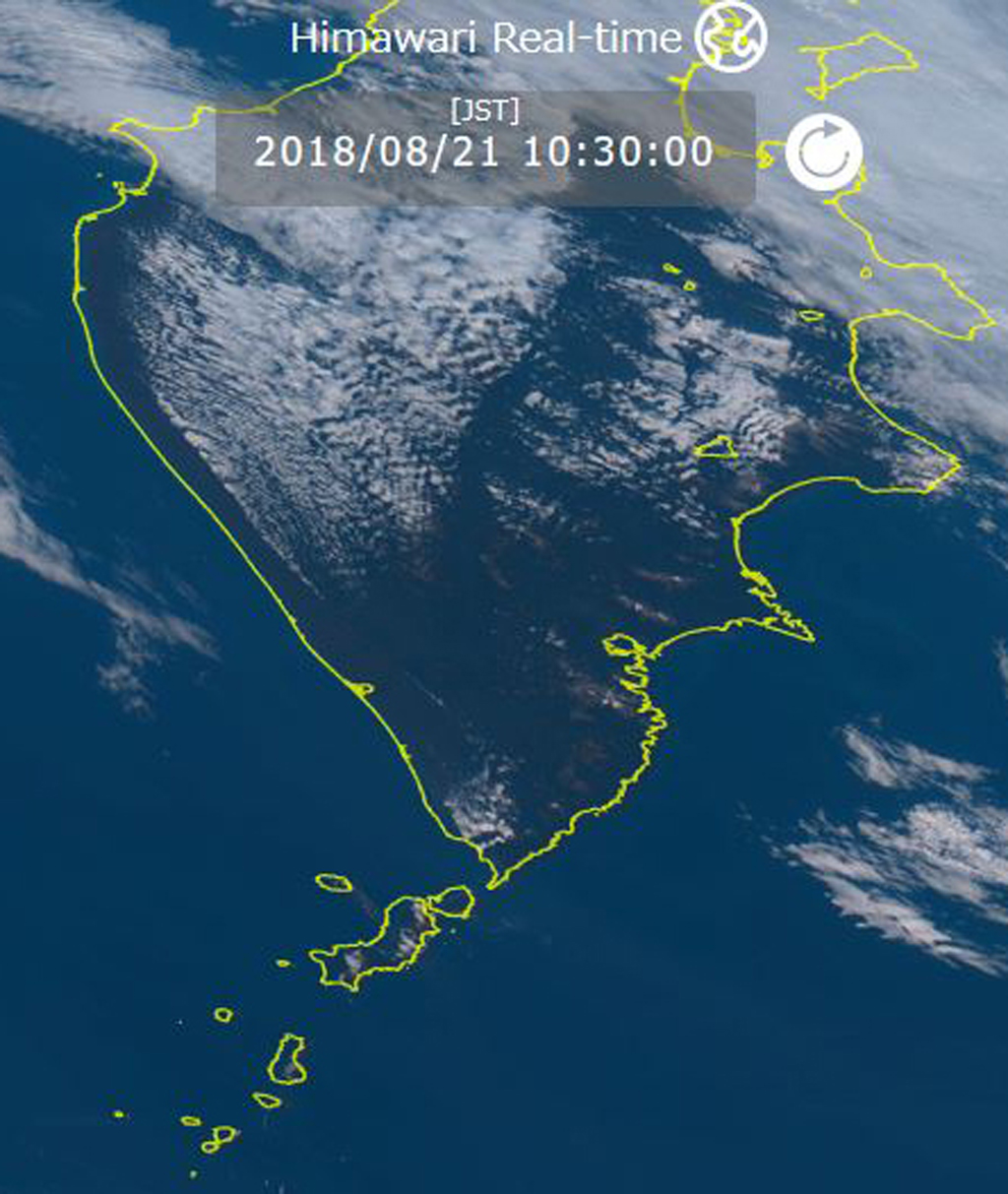 |
Figure 9. Himawari-8 satellite image from 21 August 2018 at 1030 JST (UTC + 9 hours) showing a small ash plume drifting SE from Alaid towards Paramushir Island. Alaid is the small island NW of the larger Paramushi Island and directly W of the southern tip of the Kamchatka Peninsula. Courtesy of Himawari-8 Real-time Web. |
Geological Summary. The highest and northernmost volcano of the Kuril Islands, Alaid is a symmetrical stratovolcano when viewed from the north, but has a 1.5-km-wide summit crater that is breached open to the south. This basaltic to basaltic-andesite volcano is the northernmost of a chain constructed west of the main Kuril archipelago. Numerous pyroclastic cones are present the lower flanks, particularly on the NW and SE sides, including an offshore cone formed during the 1933-34 eruption. Strong explosive eruptions have occurred from the summit crater beginning in the 18th century. Reports of eruptions in 1770, 1789, 1821, 1829, 1843, 1848, and 1858 were considered incorrect by Gorshkov (1970). Explosive eruptions in 1790 and 1981 were among the largest reported in the Kuril Islands.
Information Contacts: Tokyo Volcanic Ash Advisory Center (VAAC), 1-3-4 Otemachi, Chiyoda-ku, Tokyo, Japan (URL: http://ds.data.jma.go.jp/svd/vaac/data/); Kamchatka Volcanic Eruptions Response Team (KVERT), Far Eastern Branch, Russian Academy of Sciences, 9 Piip Blvd., Petropavlovsk-Kamchatsky, 683006, Russia (URL: http://www.kscnet.ru/ivs/kvert/); Institute of Volcanology and Seismology, Far Eastern Branch, Russian Academy of Sciences (IVS FEB RAS), 9 Piip Blvd., Petropavlovsk-Kamchatsky 683006, Russia (URL: http://www.kscnet.ru/ivs/eng/); Himawari-8 Real-time Web, developed by the NICT Science Cloud project in NICT (National Institute of Information and Communications Technology), Japan, in collaboration with JMA (Japan Meteorological Agency) and CEReS (Center of Environmental Remote Sensing, Chiba University) (URL: https://himawari8.nict.go.jp/).