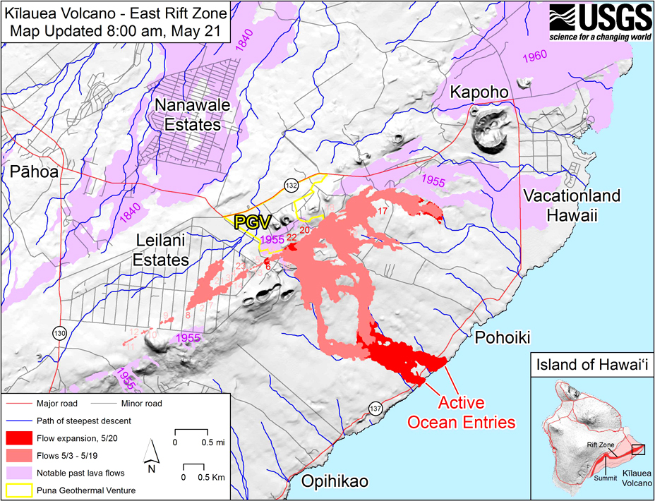
Kilauea
United States
19.421°N, 155.287°W; summit elev. 1222 m
All times are local (unless otherwise noted)
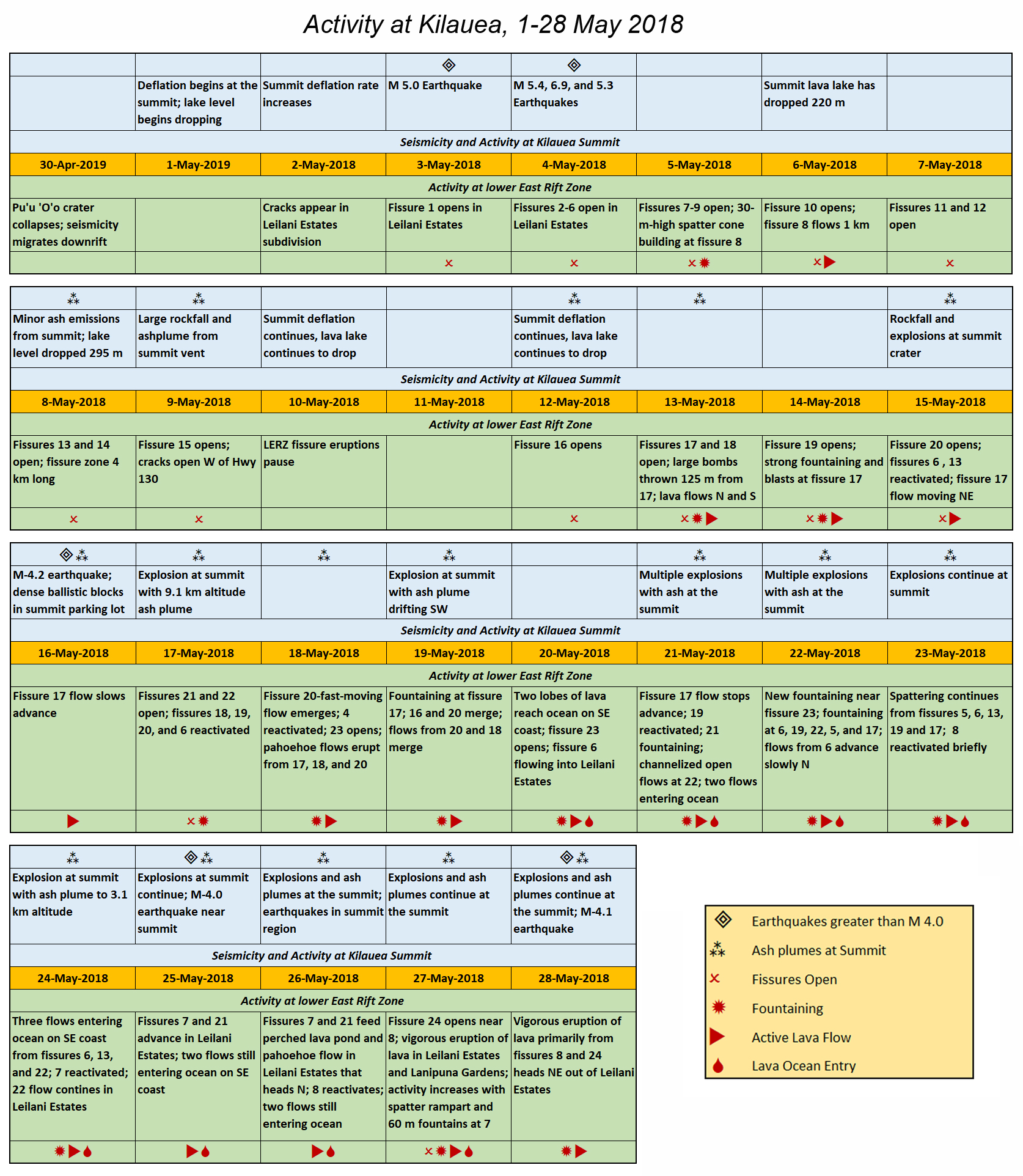
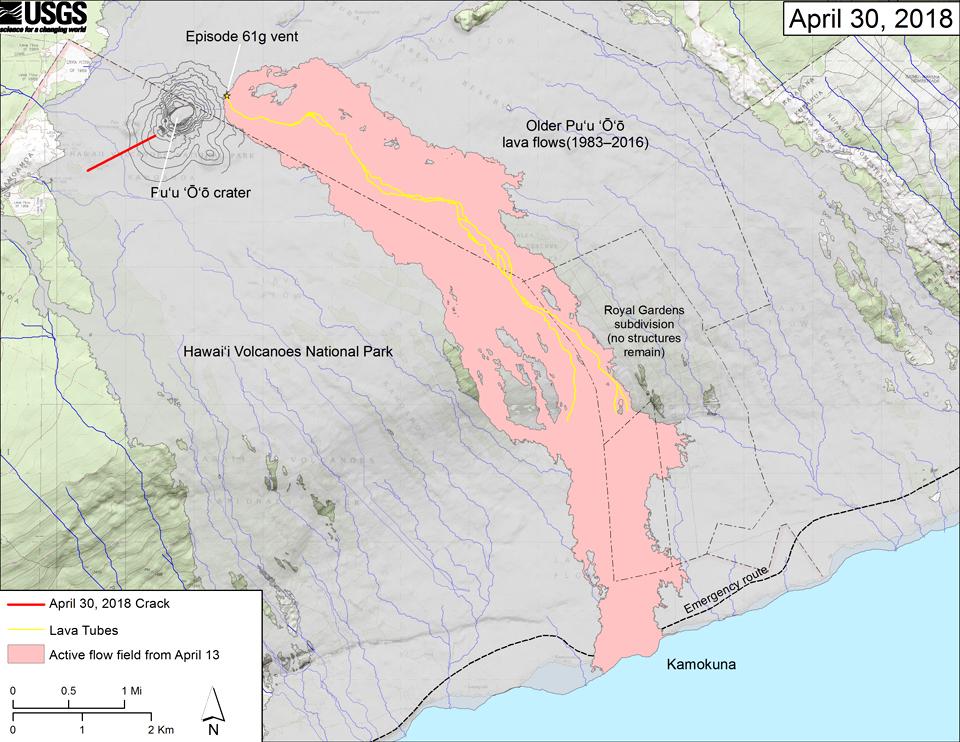
Kīlauea's East Rift Zone (ERZ) has been intermittently active for at least two thousand years. Open lava lakes at the summit caldera, and a lava lake and flows from the East Rift Zone, have been almost continuously active since the current eruption began in 1983. A marked increase in seismicity and ground deformation at Pu'u 'O'o Cone on the upper East Rift Zone during the afternoon of 30 April 2018 and the subsequent collapse of its crater floor marked the beginning of the largest lower East Rift Zone eruptive episode in at least 200 years. The daily events of this episode underscored the nature of the interconnected components of the volcanic system. The lava lake level at Halema'uma'u began dropping on 1 May 2018, and fissures first opened on the lower East Rift Zone two days later. The eruptive events of May 2018 (figure 332), the first month of this episode, are described in this report with information provided primarily from the US Geological Survey's (USGS) Hawaiian Volcano Observatory (HVO) in the form of daily reports, volcanic activity notices, and abundant photo, map, and video data.
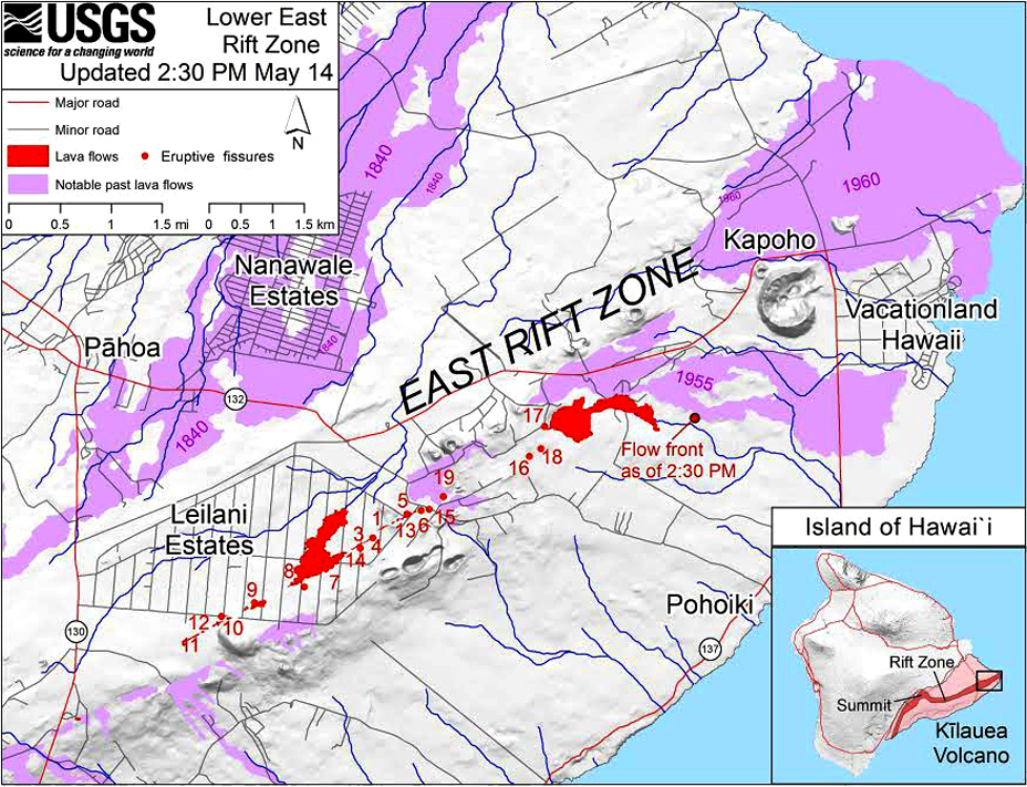
Summary of events. During 1-11 May, seismicity propagated eastward from Pu'u 'O'o, indicating the intrusion of magma into the middle and lower East Rift Zone (LERZ). The first surface cracks appeared in the LERZ on 2 May, and the first eruptive fissure opened the next afternoon. Fissures were several hundred meters long and formed a NE-SW trending line near the axis of the LERZ that reached about 4 km in length by 8 May. Three large (greater than M 5) earthquakes shook the island on 4 May. New fissures opened daily, with activity consisting of spattering and lava flows; the largest effusion was a flow from fissure 8 that traveled N for a little over 1 km. By 9 May, 15 fissures had opened in the vicinity of the Leilani Estates subdivision; the residents had been evacuated and numerous structures were destroyed by the flows, spatter, and fissures. Active spattering paused on 10 and 11 May, although strong degassing continued, and many cracks within the fissure zone continued to widen.
The lava lake level in the Overlook vent at Halema'uma'u crater at the summit began to drop slowly on 1 May; the rate of deflationary tilt increased by late the next afternoon. The lake level had dropped about 128 m below the vent rim by 5 May, and satellite data indicated a 10 cm subsidence of the Halema'uma'u crater floor during that time. Rockfalls from the crater walls produced ash plumes above Halema'uma'u, resulting in light ashfall in the summit area. By 8 May the lake level was 295 m below the floor of Halema'uma'u crater. Larger rockfalls caused by the dropping lake level generated larger explosions and ash plumes on 9 May.
New fissures began opening again on 12 May in an area about 1.5 km NE of the previous activity on the LERZ, and over the following 11 days flow activity increased substantially, creating multiple flow channels. The fissure 17 flow reached 2.5 km in length on 15 May. A fast-moving flow from fissure 20 headed 4 km SE on 18 May, traveling over 300 m per hour. The two lobes of the flow reached the SE Puna coast overnight on 19-20 May and were joined by another adjacent flow to the west two days later. Fissures 16-23, all located in the NE half of the fissure zone, were active during 12-23 May.
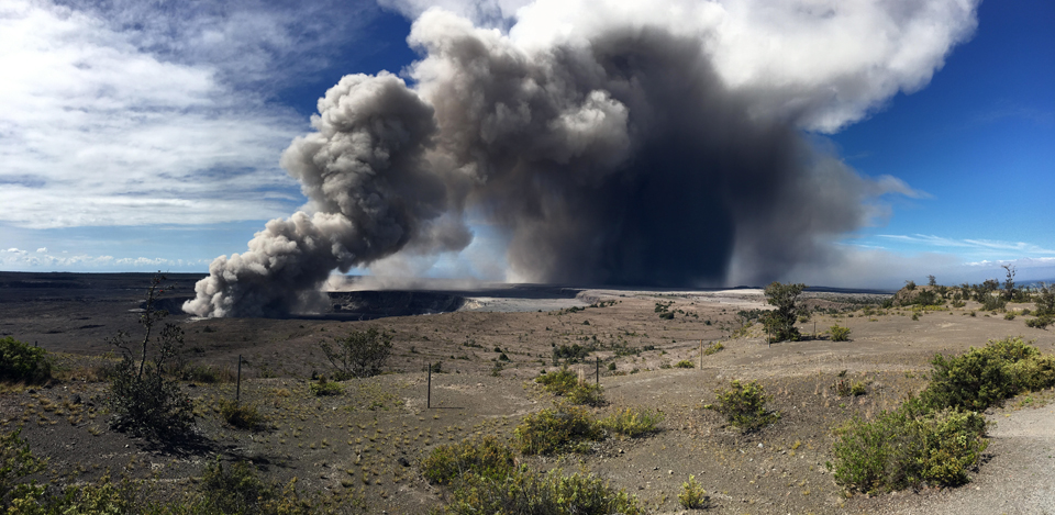
Steam and ash emissions were persistent at Halema'uma'u crater during 12-23 May; they varied in intensity with abrupt increases associated with large rockfalls into the vent, and ashfall reported more than 50 km from the summit. Strong earthquakes at the summit continued in response to the deflation, causing frequent ground shaking and damage to roads and buildings. A large explosion on 17 May generated the highest ash plume for the period; it reached 9.1 km altitude and drifted NE. Intermittent explosive eruptions continued at the summit, and robust plumes of gas, ash, and steam periodically emerged from the Overlook vent.
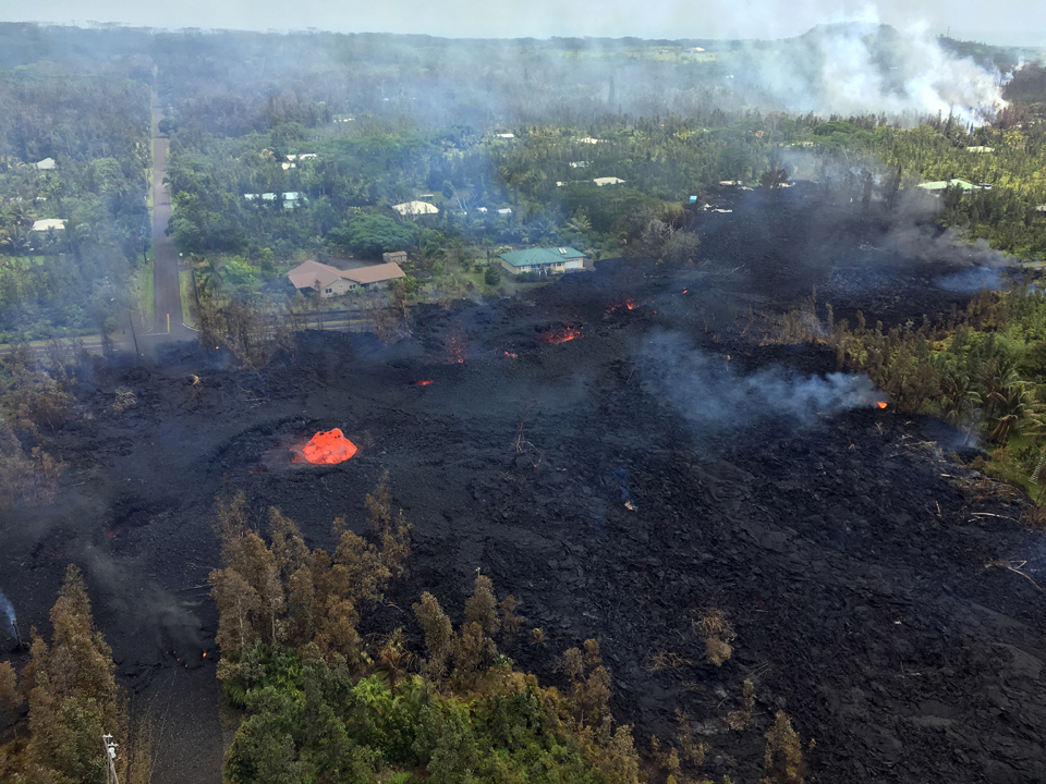
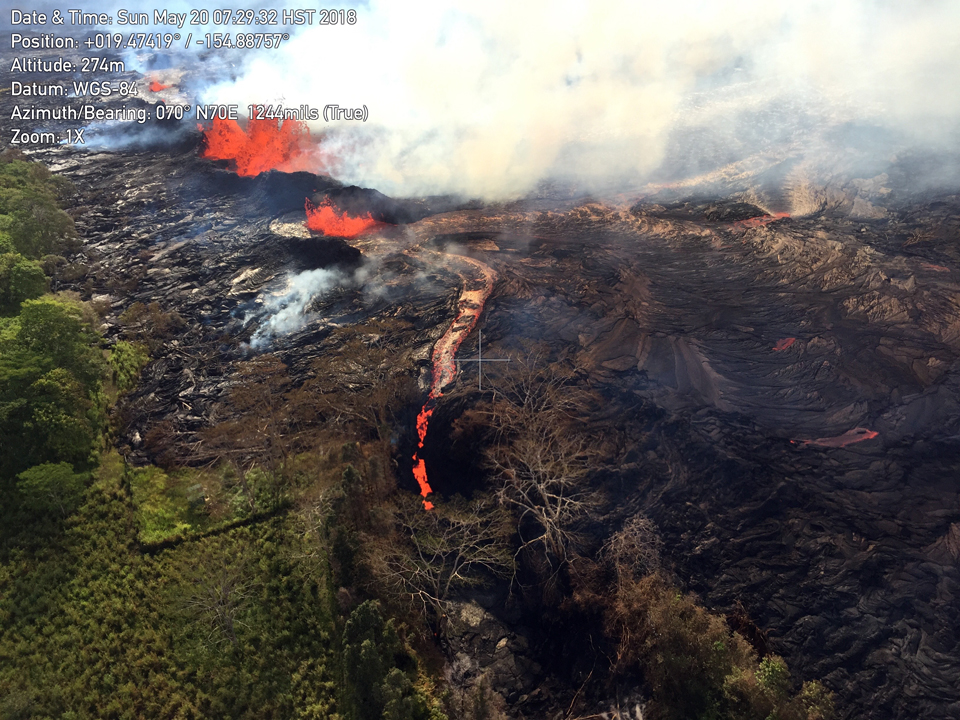
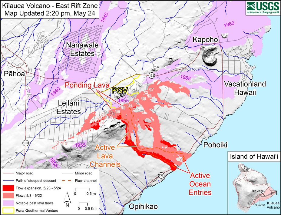
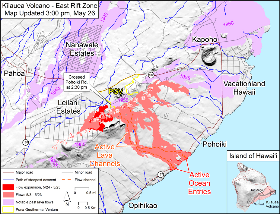
Beginning on 24 May, activity on the LERZ shifted back towards the SW part of the fissure zone, again impacting the residents of the Leilani Estates subdivision with reactivation of fissures and new flows. While flows continued to reach the ocean on the SE coast, the volume of lava gradually decreased until the supply of lava ceased by 28 May. During 24-26 May fissures 7 and 21 were feeding a perched lava pond and flows that moved E and N within the subdivision. Overnight on 26-27 May activity increased substantially at fissure 7 with a 30-m-tall spatter rampart, and fountains that reached 70 m high feeding a flow moving N. Large cracks opened into fissure 24 adjacent to the reactivated fissure 8; fast-moving flows traveled W then N through the subdivision. By 28 May the eruptive activity was focused on vigorous fountaining at fissure 8, which supplied a voluminous flow that headed rapidly NE.
Intermittent explosions continued from the summit Overlook vent during 24-28 May as a result of the ongoing subsidence at Halema'uma'u. Ash clouds generally rose to about 3.1 km altitude and drifted SW. Earthquakes in the summit region continued as the summit area subsided and adjusted to the withdrawal of magma.
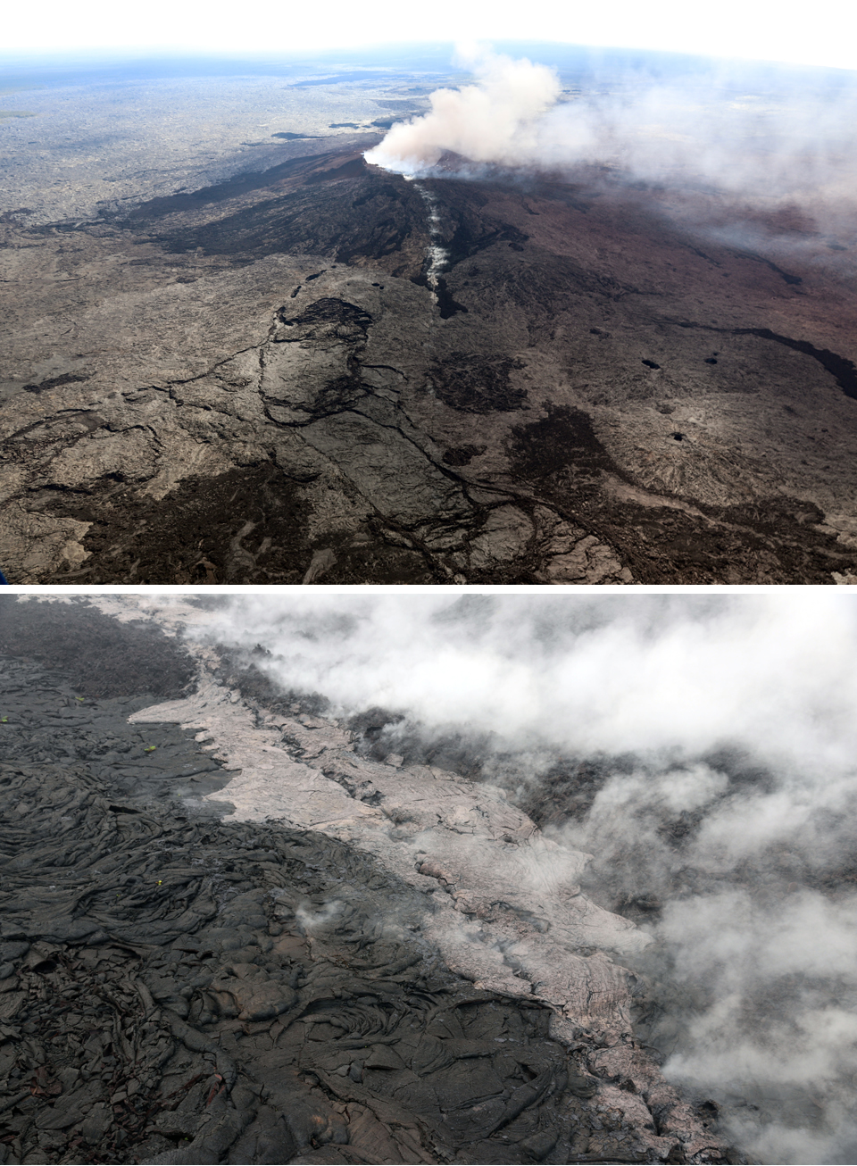
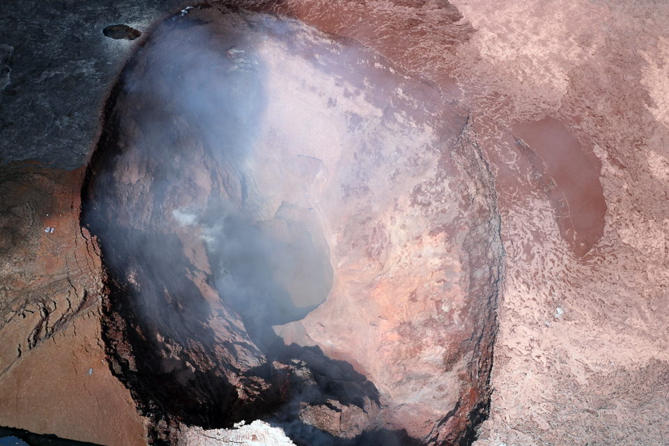
Activity during 1-11 May 2018. An intrusion of magma began overnight on 30 April-1 May into the lower East Rift Zone (LERZ), extending from the vicinity of Pu'u 'O'o eastward at least as far as Highway 130 (15 km E of Pu'u 'O'o). The intrusion began after the collapse of the Pu'u 'O'o crater floor on the afternoon of 30 April; about 250 located earthquakes were reported through the afternoon of 1 May, with the locations migrating eastward during the day. The seismicity consisted primarily of small-magnitude (less than M 3) earthquakes at depths of less than 10 km. During a helicopter overflight to Pu'u 'O'o on 1 May, HVO geologists observed a new fissure and crack extending about 1 km uprift (west) from the W flank of the Pu'u 'O'o cone (figures 333 and 334). A small amount of lava had erupted from the crack, apparently during the collapse of the Pu'u 'O'o crater floor. They also noted a few small, sluggish breakouts of the 61g lava flow, likely from lava still moving through the lava-tube system.
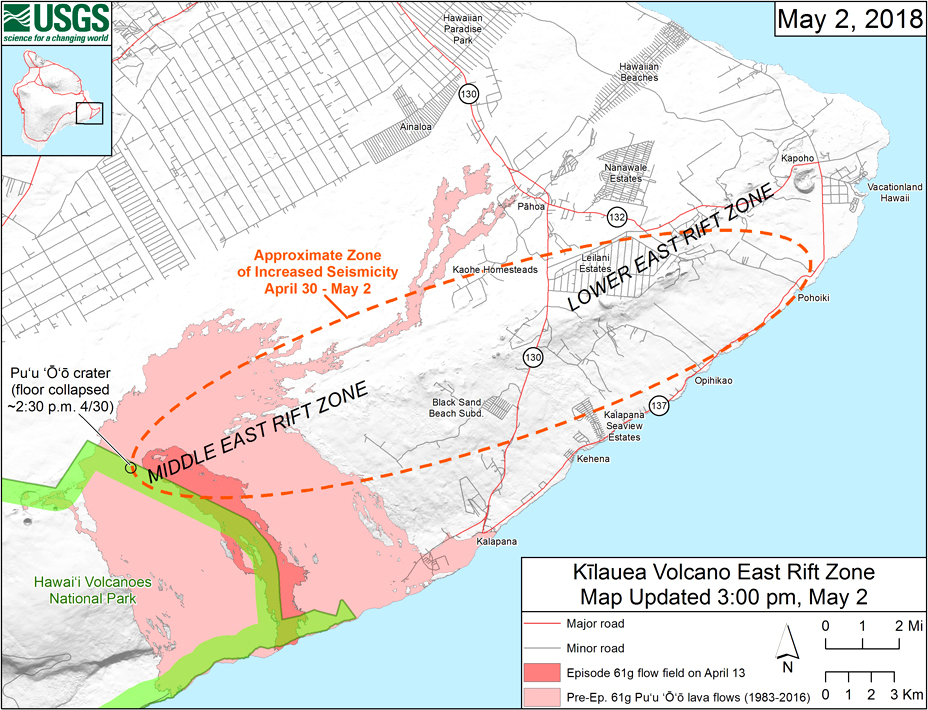
Overnight on 1-2 May, earthquakes continued at a high rate in the area from Highway 130 eastward towards Kapoho (32 km NE of Pu'u 'O'o). Many events were felt by residents and there were reports of nearly constant ground vibration in some areas; seismicity generally migrated eastward (figure 335). During the morning of 2 May a GPS station located about 1.5 km SW of Nanawale Estates (24 km NE of Pu'u 'O'o ) began moving toward the north by several centimeters, indicating the approaching magma intrusion. A tiltmeter at Pu'u 'O'o recorded steady, deflationary tilt throughout the day, with several sharp inflation offsets. Some of these offsets corresponded to short-lived ashy plumes rising from the crater. New small ground cracks less than a few centimeters wide developed across some roads in and adjacent to Leilani Estates (23 km NE of Pu'u 'O'o).
The summit lake level showed very little change immediately after the collapse of the Pu'u 'O'o crater floor, but tiltmeters at the summit began recording deflationary tilt in the early morning of 1 May. The lava lake level had dropped about 20 m by the afternoon of 2 May when the rate of deflationary tilt increased. By the evening of 3 May, it had dropped an additional 37 m.
At 1030 HST on 3 May 2018 ground shaking from a M 5.0 earthquake south of Pu'u 'O'o caused rockfalls and possibly additional collapse into the Pu'u 'O'o crater (figure 336). A short-lived plume of ash produced by this event rose and dissipated as it drifted SW (figure 337).
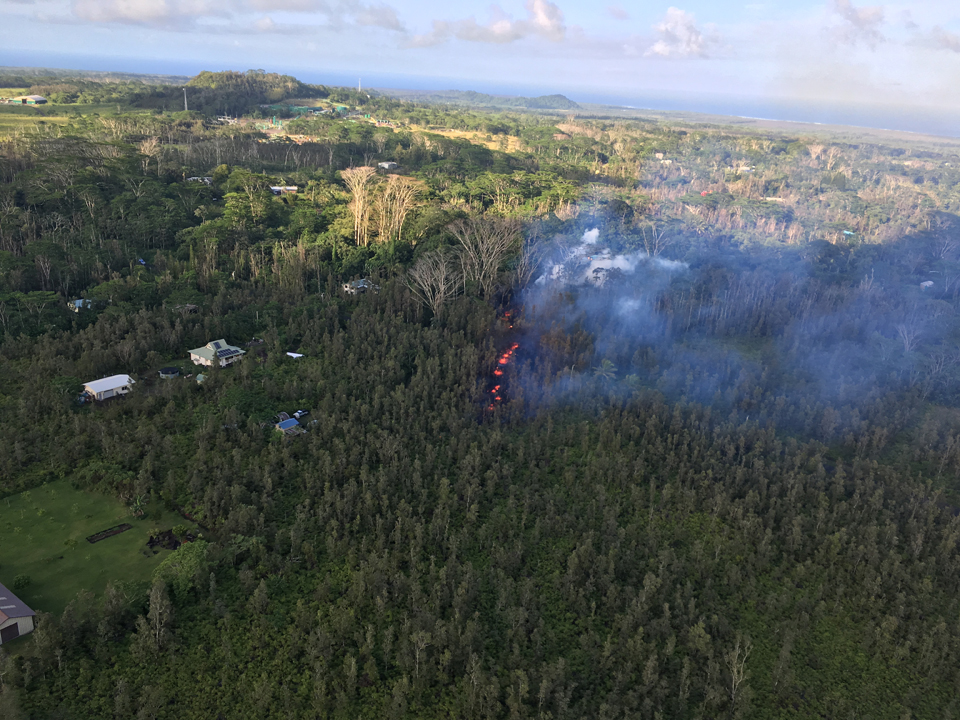
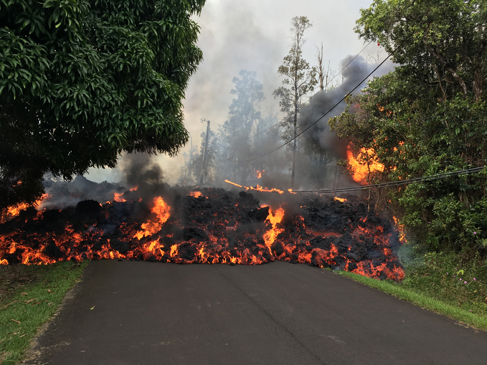
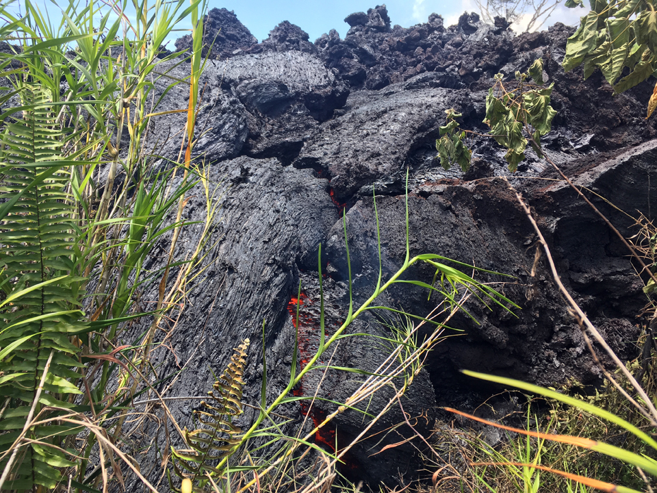
New ground cracks were reported in Leilani Estates late in the afternoon of 3 May. Hot white vapor and blue fumes emanated from an area of cracking in the eastern part of the subdivision. Spatter began erupting from the cracks shortly before 1700 local time. The Hawaii County Civil Defense coordinated the evacuation of the subdivision. Lava spatter and gas bursts erupted from the fissure for about two hours; lava spread less than 10 m (figure 338).
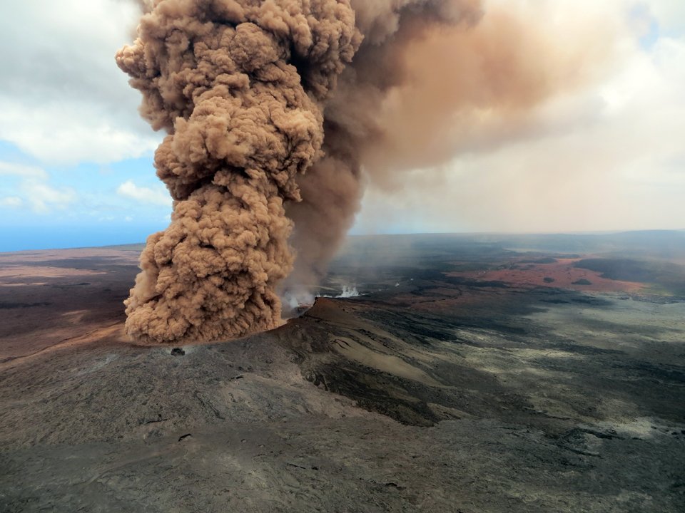
By the morning of 4 May 2018 three fissures had opened in the eastern portion of Leilani Estates; activity consisted primarily of vigorous lava spattering and development of short lava flows (figure 339). Additional eruptive fissures or vents opened during the day, each several hundred meters long (figure 340). Spatter and lava accumulated primarily within a few tens of meters of the vents. Fissure 6 opened on the eastern edge of the subdivision by the afternoon. Between 1130 and 1500 three large earthquakes (M 5.4, M 6.9, and M 5.3) shook the island along with numerous lower-magnitude events. The M 6.9 event at 1232 HST (the largest on the island in 43 years) produced a robust ash plume at Pu'u 'O'o (figure 341), and numerous rockfall events were triggered at both Pu'u 'O'o and Halema'uma'u craters.
Fissures 7, 8, and 9 opened in the Leilani Estates subdivision on 5 May. Fissure 7 was only active until mid-afternoon (figure 342). Fissure 8 activity included fountaining and occasional bursts of spatter to 100 m as well as building a spatter cone (figure 343); the flow from fissure 9 migrated W. New ground cracks were reported on Highway 130 along the W edge of the subdivision.
Tiltmeters at the summit continued to record a deflationary trend. Satellite InSAR data showed that between 23 April and 5 May 2018 the summit caldera floor subsided about 10 cm. Corresponding to this deflation, the lava lake in the Overlook vent had dropped about 128 m below the crater rim during that same period. Rockfalls from the crater walls into the retreating lake produced ashy plumes above Halema'uma'u crater, resulting in light ashfall in the summit area. During 4 and 5 May about 152 M 2 and M 3 earthquakes occurred at depths less than 5 km beneath the summit area. These earthquakes were related to the ongoing subsidence of the summit area and south flank of the volcano.
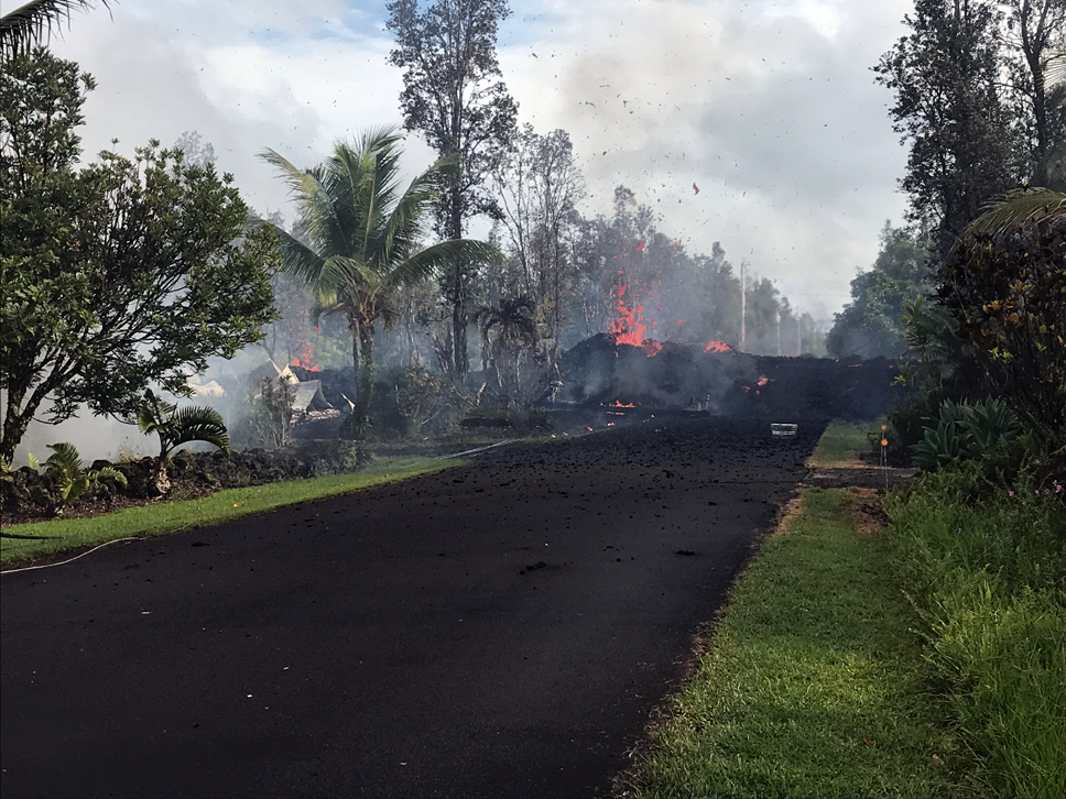
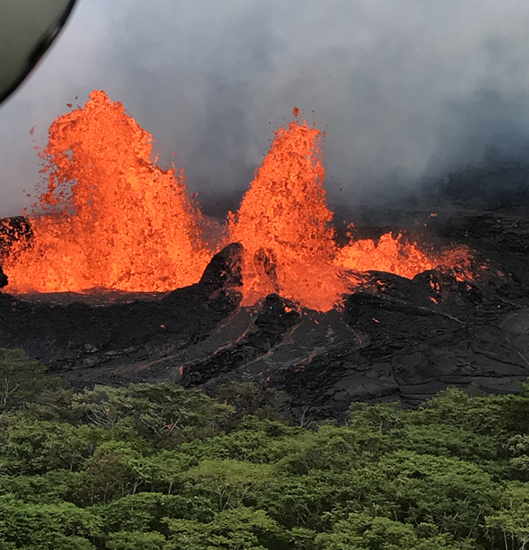
Fissure 8 erupted lava fountains until about 1600 on 6 May. By early that afternoon, ten fissures had opened in the Leilani Estates subdivision, but not all were continuing to erupt (figure 344). A lava flow from fissure 8 advanced northward, reaching 1.1 km in length by early evening (figure 345). Deflation continued at the summit with the lava lake dropping at a rate of about 2 m per hour throughout the day, and by evening it had dropped a total of 220 m since 30 April (figure 346).
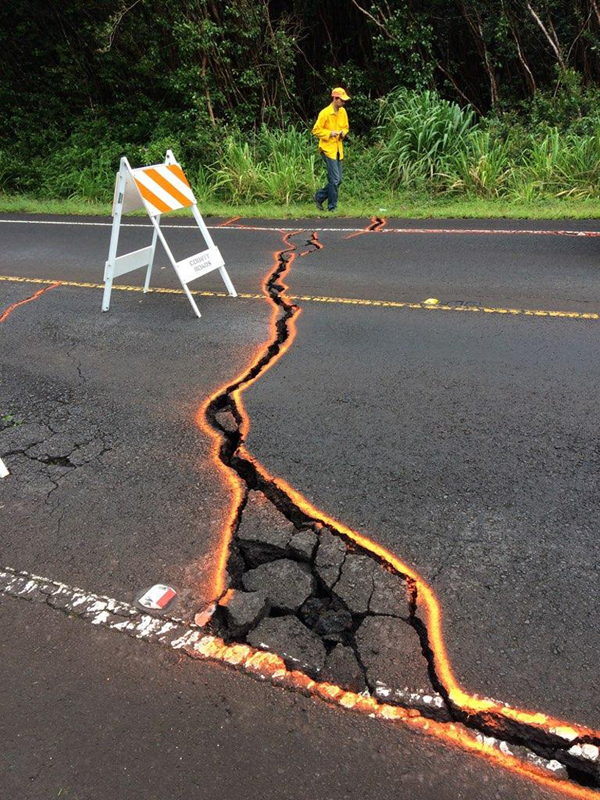
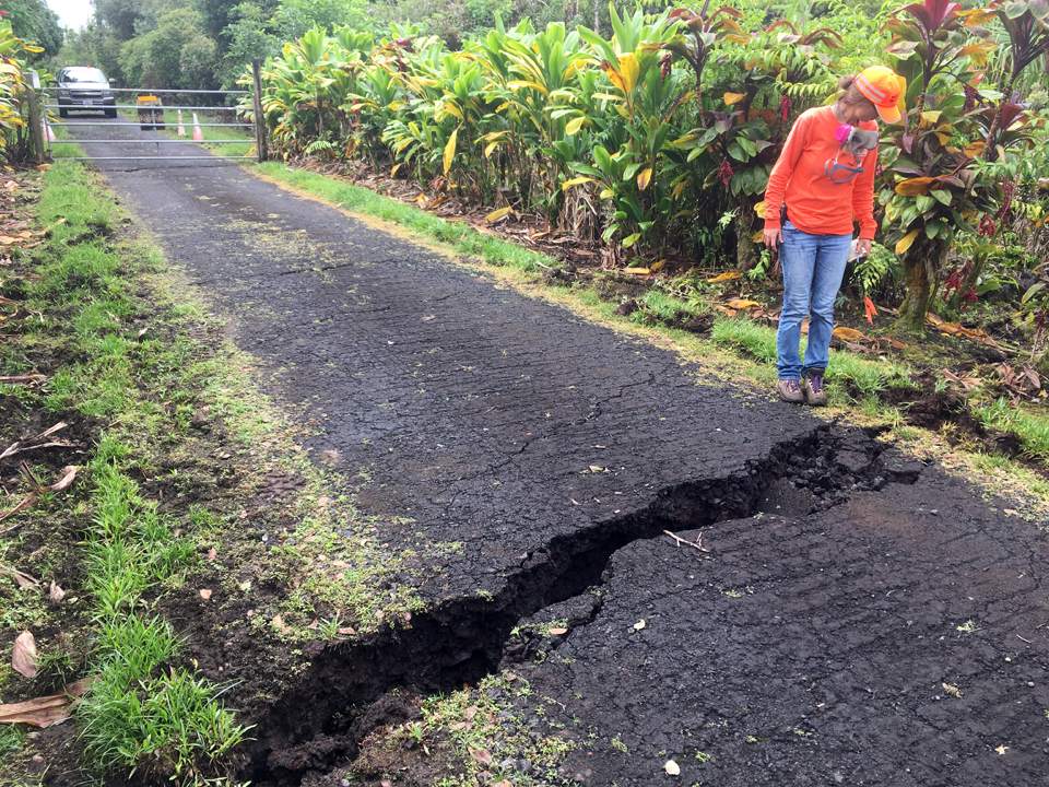
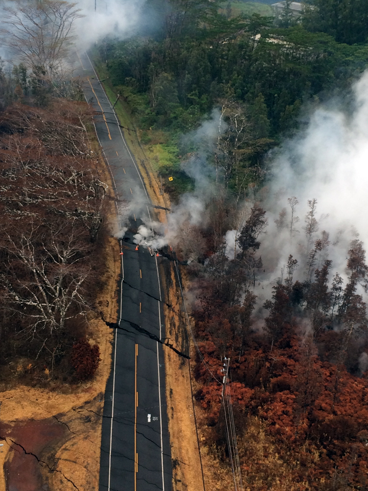
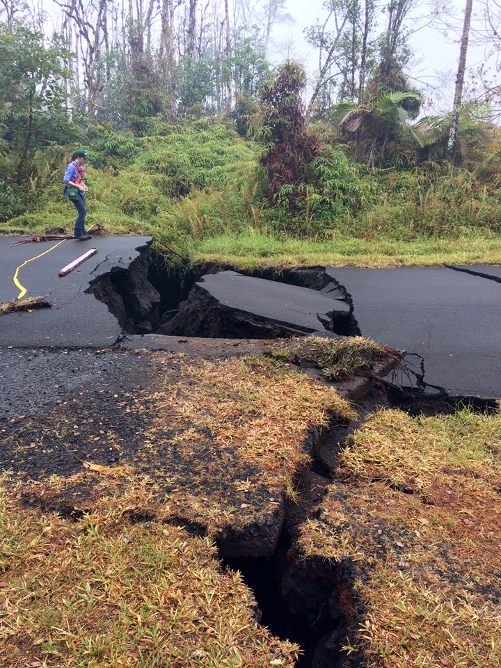
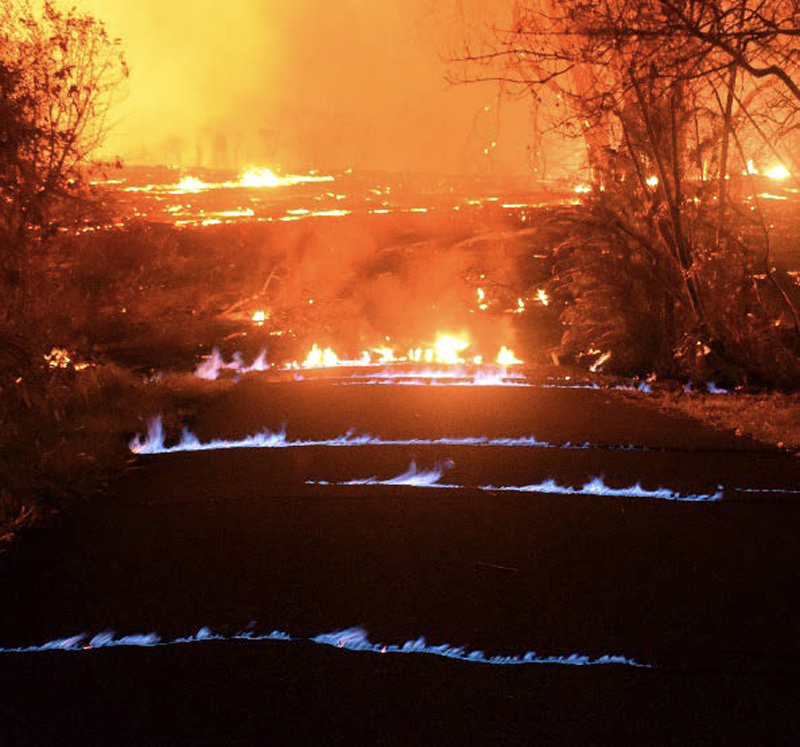
Two new fissures broke ground in the morning on 7 May. The first (fissure 11) opened in a forested area SW of Leilani Estates and was active for only 3 hours. The second (fissure 12) opened around noon between fissures 10 and 11. By 1515 both new fissures were inactive but the west end of fissure 10 was steaming heavily. Cracks on Highway 130 widened from 7 to 8 cm over the course of the day and additional cracks were found just W of the highway on trend with the previous fissures (figure 347).
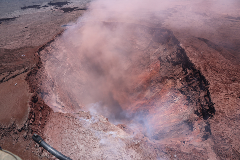
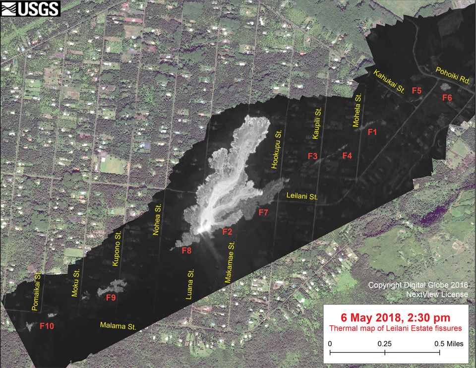
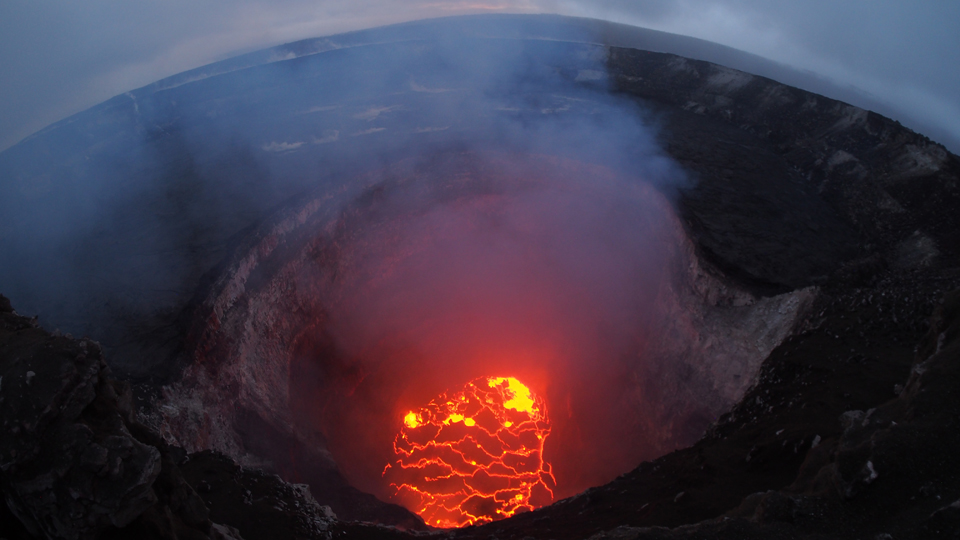
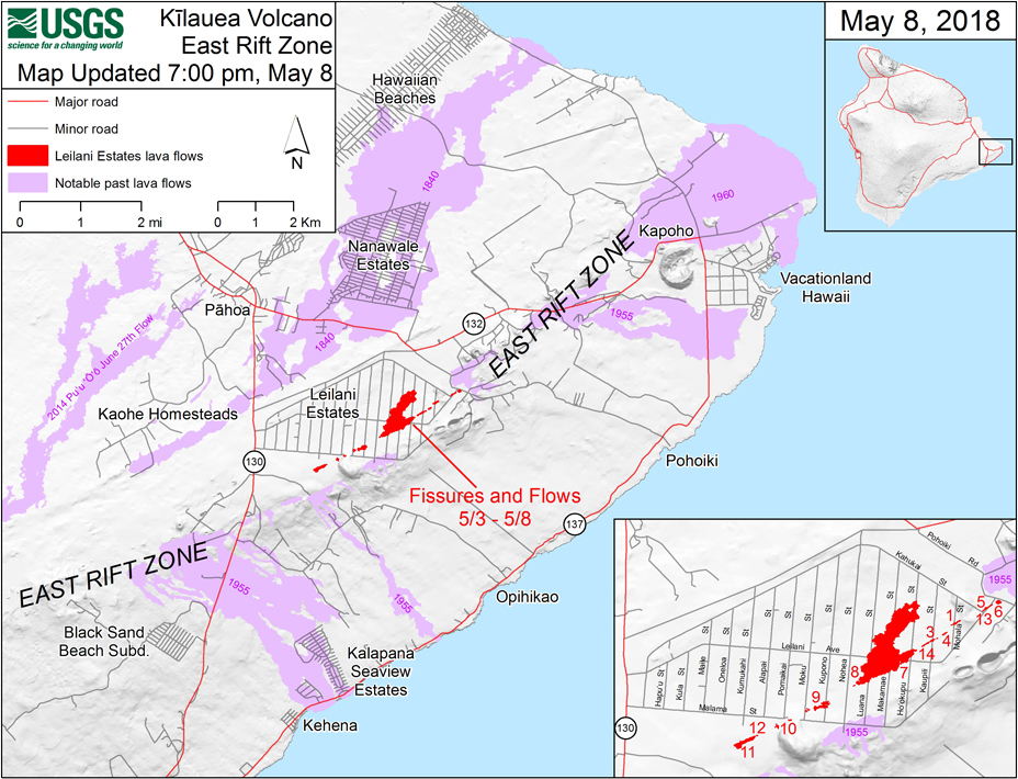
By the evening of 8 May 2018, the overall fissure zone was about 4 km long (figure 348), stretching SW-NE across most of the now-evacuated Leilani Estates subdivision; 14 distinct fissures had been mapped, and a lava flow starting from fissure 8 had traveled about 1 km NE from its source. Officials noted that 35 structures had been destroyed. Loud jetting and booming noises were heard from fissure 13 that evening. Rockfalls into the Overlook vent at the summit were intermittently producing small ash plumes that rose several hundred meters above the summit and traveled downwind as the lava lake continued to fall. Based on model data collected in the afternoon, the lake level was about 295 m below the floor of Halema'uma'u Crater by the end of the day on 8 May.
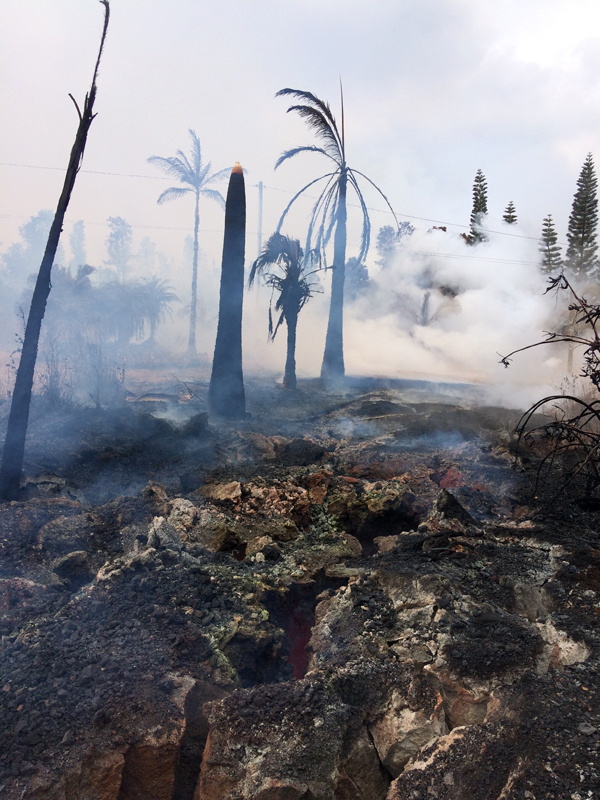
At 0832 HST on 9 May 2018, a large rockfall from the steep crater walls into the summit lava lake triggered an explosion that generated an ash column above Halema'uma'u crater; the ash was blown SSW (figure 349). During the day on 9 May fissure 15 broke ground at the NE edge of the LERZ fissure area and generated a pahoehoe flow about 20 m long. Severe ground cracks associated with fissure 14 were steaming vigorously in the morning (figure 350). During an overflight around 1500 in the afternoon HVO geologists also noticed an area of steaming uprift (west) of Highway 130 at the SW edge of the fissure area. Rates of motion increased late in the morning at a GPS station located 1.5 km SE of Nanawale Estates (about 2 km N of Leilani Estates). The direction of motion was consistent with renewed movement of magma in the downrift direction (to the NE).
Strong degassing continued from existing fissures on 10 and 11 May; although active spatter and lava had paused, several cracks within the fissure zone continued to widen (figure 351). A 3D model constructed of thermal images of Pu'u 'O'o crater taken on 11 May indicated that the deepest part of the crater was 350 m below the rim (figure 352). Hawai'i Volcanoes National Park closed to the public on 11 May due to heightened (daily) earthquake activity at the summit, and concerns about a potentially larger summit explosion.
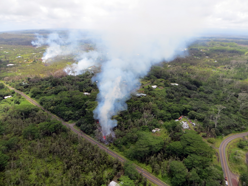
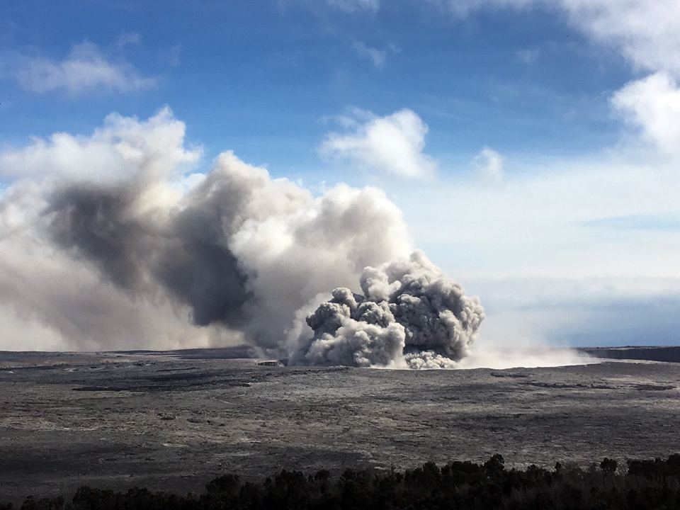
Activity during 12-23 May 2018. Minor spattering resumed from a new fissure (16) that opened about 0645 on 12 May around 1.5 km NE of fissure 15, at the NE end of the existing vent system (figure 353). It produced a lava flow that traveled about 230 m before stalling in the early afternoon. A steady, vigorous plume of steam and variable amounts of ash rose from the Overlook vent and drifted SW. Over the course of the day, rockfalls from the steep enclosing crater walls at the summit crater periodically generated small ash clouds mixed with water vapor. These ash clouds rose only about a hundred meters above the ground, a few generating very localized ashfall downwind.
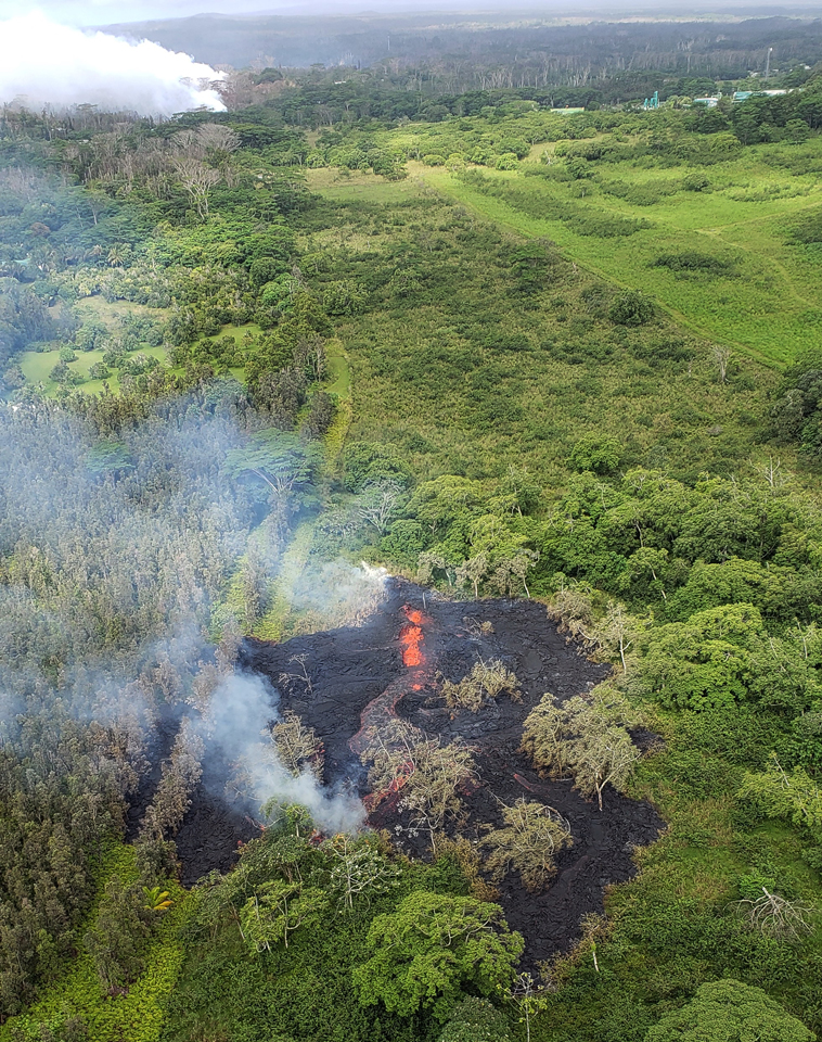
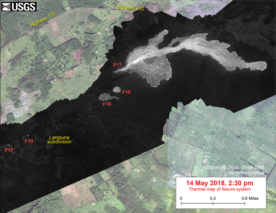
A plume of steam and volcanic gas, occasionally mixed with ash, rose from the Overlook vent within Halema'uma'u for much of the day on 13 May 2018. That morning, a new outbreak was reported about 0.5 km NE of fissure 16. Aerial observations of this new fissure (17) indicated it was at least several hundred meters long and produced spatter rising tens of meters into the air. By late in the day, activity was dominated by lava fountaining, explosions of spatter bombs, and several advancing lava flow lobes moving generally NE at the downrift (NE) end of the new fissure system. As of about 1900 on 13 May, one lobe was 2 m thick and advancing roughly parallel to Highway 132 (figure 354). A smaller fissure 18, a few hundred meters S of 17, was weakly active late in the day. A new fissure (19) was spotted early on 14 May producing a sluggish lava flow. By 1430 on 14 May, fissure 17 was producing a lava flow extending about 1.7 km from the fissure (figure 355).
Activity on the LERZ on 15 May 2018 was concentrated at fissure 17 with intermittent spattering at fissure 18; the fissure 17 flow continued to slowly advance ESE reaching a length of nearly 2.5 km in the early morning (figures 356 and 357). A new fissure (20) opened up SW of fissure 18 and produced two small pads of lava. During the morning, ash emissions from the Overlook vent inside Halema'uma'u varied greatly in intensity with abrupt increases likely associated with large rockfalls deep into the vent (figure 358). Ashfall was reported as far away as Discovery Harbor (55 km SW), Pahala (30 km SW), at locations along Highway 11 from Pahala to Volcano, and in the Ka'u Desert section of Hawaii Volcanoes National Park near the summit. NWS radar and pilot reports indicated the top of the ash cloud ranged from 3.0 to 3.7 km altitude.
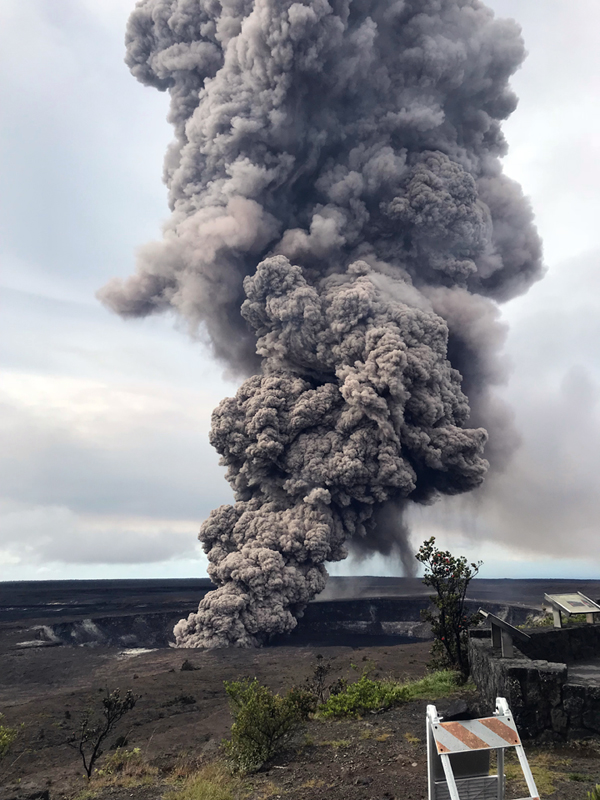
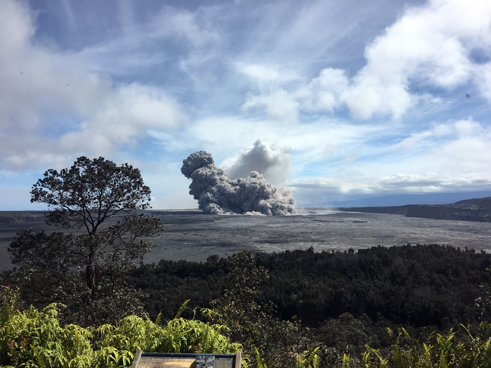
On the morning of 16 May dense ballistic blocks up to 60 cm across were found in the parking lot a few hundred meters from Halema'uma'u crater, reflecting the most energetic explosions to date. Strong earthquakes within the summit continued in response to ongoing deflation and lava column drop. By the afternoon of 16 May the floor of the larger Kīlauea Caldera had dropped 90 cm from the ongoing deflation, stressing faults around the caldera and causing multiple earthquakes. Employees at the Hawaiian Volcano Observatory, Hawai`i Volcanoes National Park, and nearby residents reported frequent ground shaking and damage to roads and buildings. The decision was made to evacuate HVO's office building on Uekahuna Bluff overlooking Halema'uma'u Crater. Low-level eruption of lava continued from multiple points along the NE end of the active fissure system on the lower East Rift Zone, but spattering generally decreased in vigor throughout the day.
At about 0415 on 17 May an explosion from the Overlook vent produced a volcanic cloud that reached 9.1 km altitude and drifted NE. Traces of ash fell with rain on the Volcano Golf Course, in Volcano Village, and in other areas immediately around the summit (figure 359). Subsequent continued emissions reached 3.7 km altitude; vog or volcanic air pollution produced by volcanic gas was reported in Pahala. After the explosion, seismic levels increased gradually throughout the day.
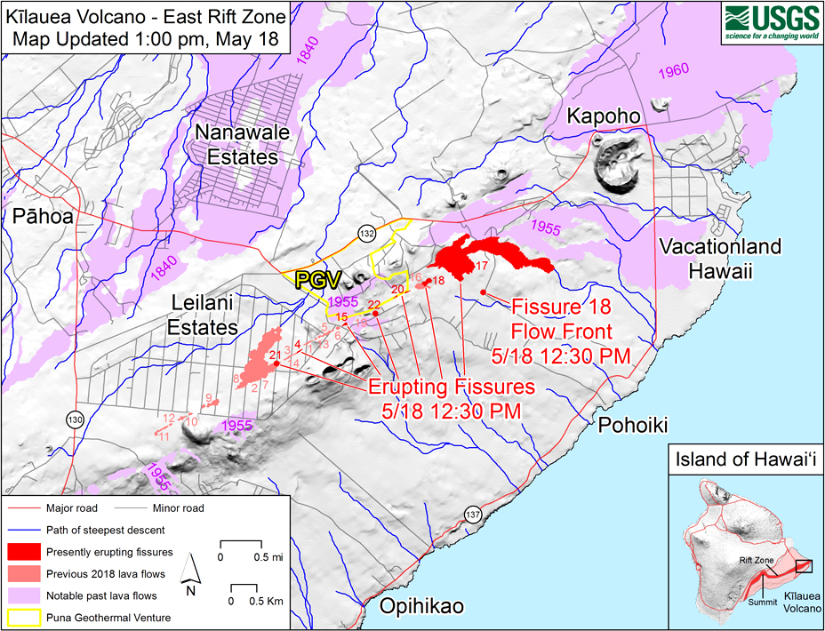
At the LERZ, fissures 18, 19, and 20 reactivated during the afternoon of 17 May, and a new fissure opened (21) between fissures 7 and 3 (figure 360). Ground cracks continued to open and widen around Leilani Estates, several with both horizontal and vertical offsets (figures 361 and 362). An area 50-90 m wide, parallel to and N of the line of fissures between Highway 130 and Lanipuna Gardens, dropped slightly, forming a depression that pahoehoe flows from fissures 20 and 21 began filling. Fissure 22 opened just downrift of fissure 19.
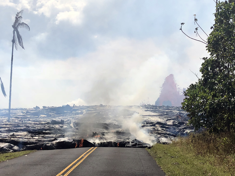
Spattering continued on 18 May 2018 from fissures 15, 17, 18, 20, 21, and new fissure 22. Pahoehoe lava flows were also erupted from fissures 17, 18, and 20 (figure 363). During the afternoon, fissure 17 was actively spattering fragments as high as 100 m, and the flow was active but had not covered new ground (figure 364). A flow from fissure 18 had traveled approximately 1 km SE. The graben area N of the fissures was still being filled by pahoehoe flows from fissures 20 and 21; fissure 15 produced a flow that crossed Pohoiki Road. Later in the afternoon a fast-moving pahoehoe flow emerged from fissure 20 and traveled SE, moving over 300 m per hour. By late that evening, the flow had three main lobes; the easternmost was E of Pohoiki Road moving about 200 m per hour while the westernmost was near Malamaki Road and moving about 40 m per hour. At the summit, for much of the day, a steady steam plume rose from the Overlook vent. Several minor emissions of ash were observed in web cameras; no significant explosions and no earthquakes greater than M 3.5 had occurred in the previous 24 hours. At 2358 local time, however, a short-lived explosion from Halema'uma'u created an ash cloud that reached up to 3.1 km altitude and was carried SW by the wind.
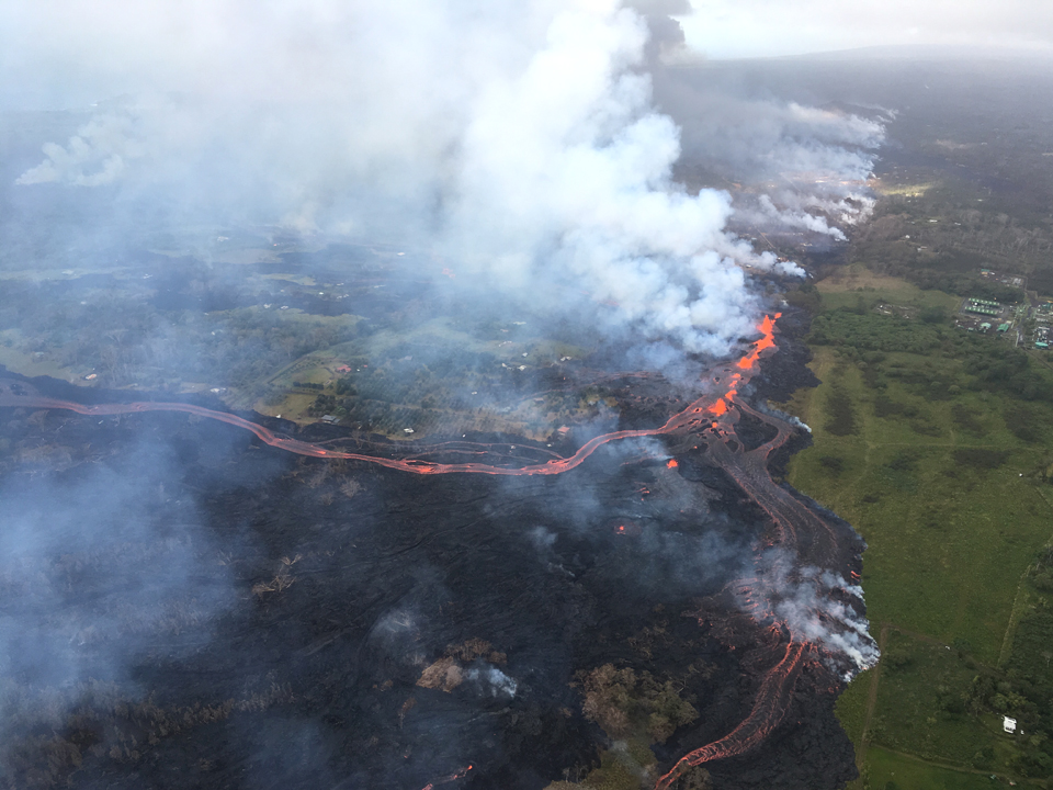
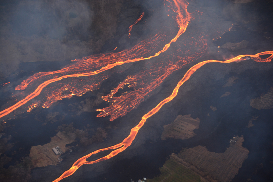
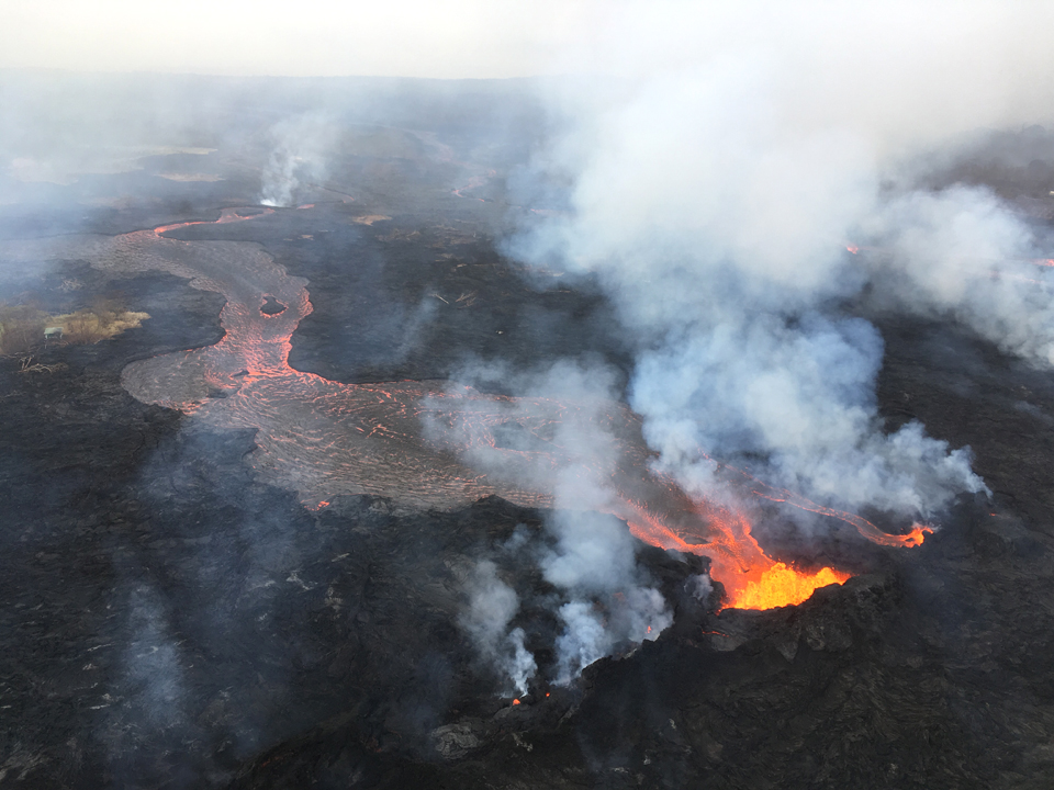
The rate of lava eruption increased overnight on 18-19 May; fountaining continued at fissure 17, and fissures 16 and 20 merged into a continuous line of spatter and fountaining. Two flows from this consolidated fissure complex were wide, very active, and advancing southward at rates up to 300 m per hour (figures 365 and 366). Flows from fissures 17 and 18 were also still active but advancing slowly, and fissure 18 had stalled by the end of the day. By mid-afternoon on 19 May the two fast-moving flows had joined about a kilometer from the coast and continued to flow southward (figure 367). The GPS instrument located on the NE side of Leilani Estates was no longer moving. While earthquake activity continued, it had not moved farther downrift in the previous few days.
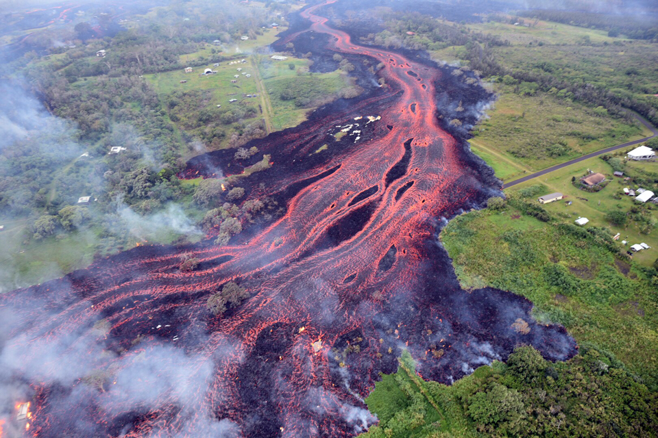
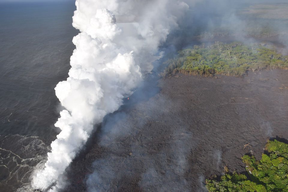
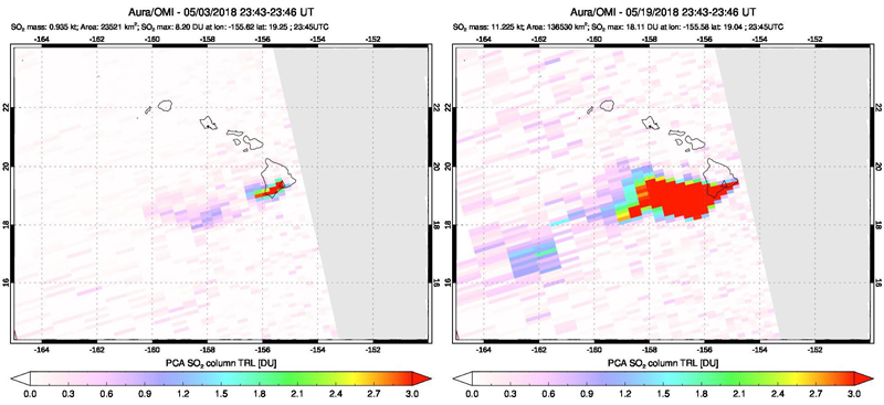
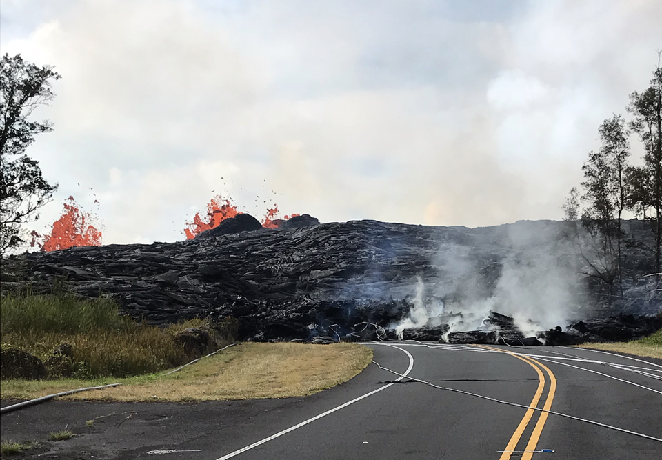
The two flows from the fissure 20 complex entered the ocean at two points along the SE Puna coast overnight on 19-20 May (figure 368). Soon after, a crack opened under the E lava channel diverting some of the lava into underground voids (figure 369) and reducing the amount of lava flowing into the ocean. Spattering continued from fissures 6 and 17 during the day on 20 May. Fissure 23 first appeared at 1100 on 20 May, at the NE corner of the Leilani Estates subdivision near fissures 4 and 14, about 2 km SW of fissure 20; it was only active during 19-20 May. Volcanic gas emissions tripled as a result of the voluminous eruptions from the fissure 20 complex; satellite instruments measured a major increase in SO2 emissions on 19 May (figure 370). Intermittent explosive eruptions continued at the summit, and plumes of gas and steam periodically emerged from the Overlook vent and drifted SW.
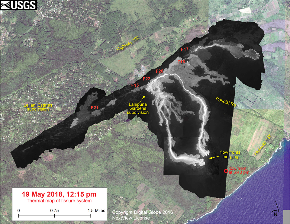
The most vigorous eruptive activity during 21-23 May in the lower East Rift Zone, was concentrated in the middle portion of the system of fissures, primarily between fissure 20 on the NE and fissure 23 on the SW (figure 371). Fountaining 50 m high from fissure 22 was feeding the channelized flow reaching the coast (figure 372). Fissure 6 reactivated with spattering and a short flow on 21 May. Fissure 17, at the NE end of the fissure system was only weakly active. On 22 May lava fountains continued from fissures 6 and 22, with fissures 19 and 5 also active; a new area of fountaining also appeared near fissure 23. Fountaining from fissures 5 and 23 fed flows in the eastern part of Leilani Estates and blue methane was observed burning in road cracks overnight on 22-23 May (figure 373). Observers noted that the height of the perched lava pond forming on the NW side of fissures 5 and 6 had reached 11 m above the ground level.
By 23 May, fountains from fissures 5, 6 (figure 374), 13, and 19 were feeding a flow advancing to the S, roughly parallel to the western flow from fissure 22 (figure 375); it reached the ocean late in the afternoon, creating multiple entry points that produced occasional small explosions. Small ash emissions from the Overlook vent occurred frequently during 21-23 May (figure 376). Fissure 8 reactivated briefly in the morning of 23 May and erupted two small pahoehoe flows over the initial `a`a flow.
Activity during 24-28 May 2018. Overnight on 23-24 May field crews observed that fissure areas 2, 7, 8, 3, 14, and 21 had reactivated and were spattering (figure 377). Fissure 22 continued to erupt lava flowing SE to the coast (figure 378). Fissures 7 and 21 were feeding a perched lava pond and pahoehoe flow that advanced eastward later that afternoon. An explosion from the summit Overlook vent just after 1800 on 24 May produced an ash cloud that rose to 3.1 km altitude and had more ash than most recent explosions (figure 379). The National Weather Service Nexrad radar tracked the cloud for 15-20 minutes; moderate trade winds were blowing to the SW.
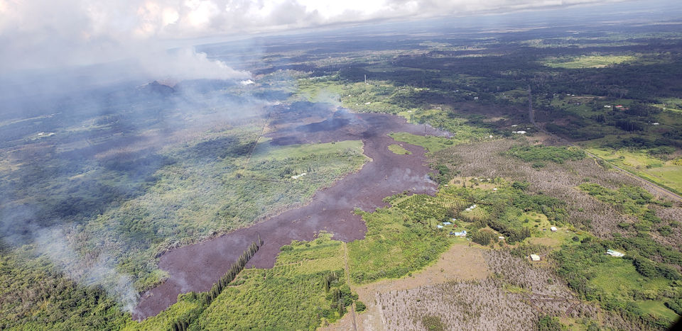
By 25 May, the two flows from fissure 22 and fissures 6 and 13 were still reaching the ocean with two entry points (figure 380); fissures 7 and 21 were feeding a flow that continued to slowly advance NE, covering several streets in Leilani Estates (figure 381). By the next day, the flow front of fissure 21 had become an 'a'a flow and was continuing to move NE (figure 382), reaching the PGV (Puna Geothermal Venture) property by late afternoon on 26 May. Fissure 7 was feeding a flow that had turned S toward the coast, and at dusk the lava was cascading into the Pawaii crater, adjacent to the western margin of the fissure 6 flow that fed one of the ocean entries. On the W side of fissure 7 a perched pahoehoe flow broke out around 0400 on 26 May, feeding short flows to the W. Multiple small eruptions continued to occur at the summit, most ejecting ash to under 3.1 km altitude. One of the largest occurred about 1617 on 25 May sending ash as high as 3.7 km altitude.
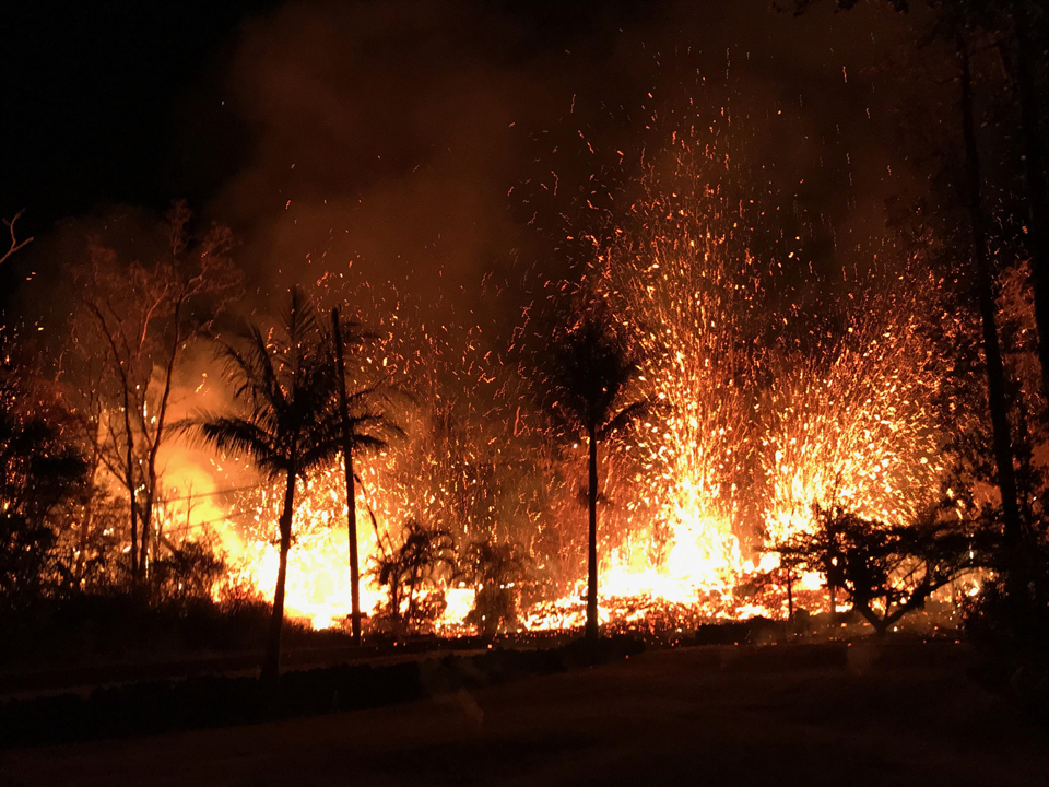
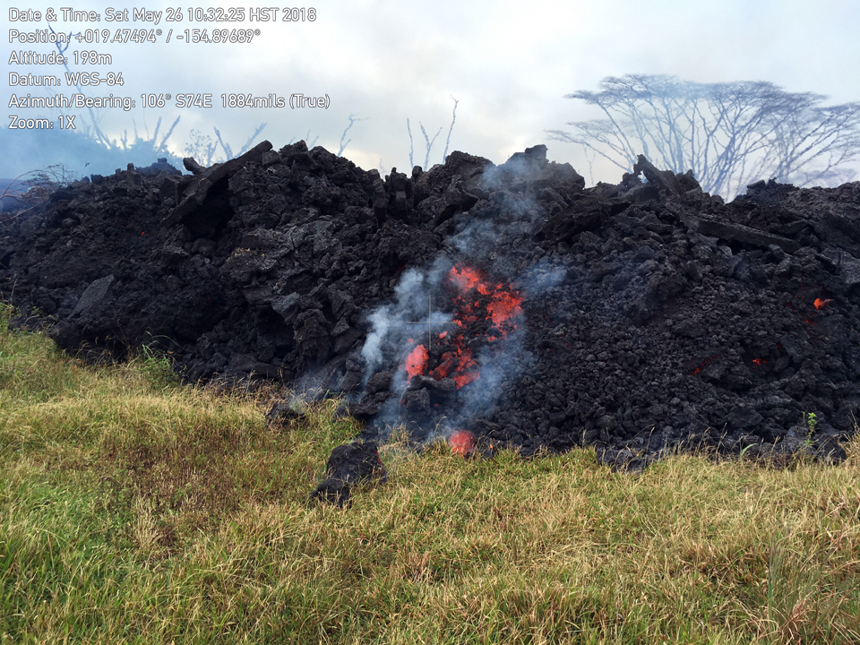
Overnight during 26-27 May fissure 17 was the source of multiple booming gas emissions. Fissure 7 activity increased overnight, producing a large spatter rampart over 30 m tall from fountains reaching 50-70 m high (figure 383). The fountains fed two perched channels, the N channel, 8-15 m thick, fed a lava flow that advanced toward pad E of the PGV property; the S channel was a flow advanced SE. Large cracks were observed overnight near fissure 9 which developed into fissure 24. Fissure 8 had three vents active overnight on 26-27 May that were spattering and flaming; they had doubled in size over the previous 24 hours.
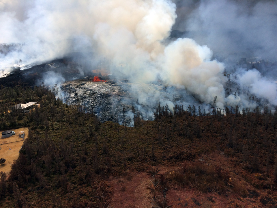
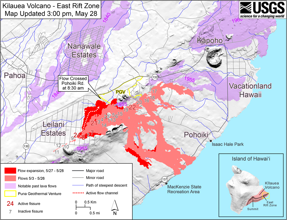
The fissure 21 'a'a flow continued to advance NE onto PGV property but at a slower pace on 27 May. By the end of the day, fissures 7 and 8 were the most active, fountaining and feeding lava flows that advanced NE onto PGV property. At about 1900 HST a fast-moving lava flow broke from this area and advanced rapidly to the N and W through the eastern portion of Leilani Estates, causing additional evacuations. Activity had noticeably diminished from fissures 22 and 13, and the supply of lava to the channel flowing to the sea had ceased by the next day, 28 May. Ash continued to erupt intermittently from the Overlook vent at the summit. Observations from the ground and by UAV during the previous week documented retreat of the Overlook vent wall due to collapse of the steep enclosing walls and rim. Trade winds carried the ash clouds primarily SW.
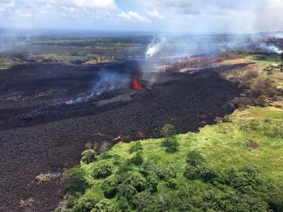
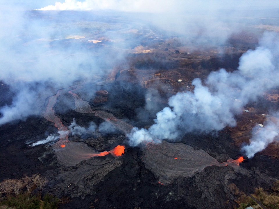
Fissure 8 fed a fast-moving flow early on 28 May that moved N along the margin of the existing fissure 7 flow before turning E and crossing out of Leilani Estates (figure 384). Flow activity from fissure 8 diminished abruptly midday and a few other fissures reactivated briefly with fissure 7/21 having the tallest fountains. Vigorous fountaining resumed at fissure 8 late in the afternoon, spawning a flow that traveled an estimated 20 m per hour to the NE over the flow of the previous day; fountains were 50-60 m tall (figure 385). During the evening, fissures 16, 18, 22, 13, and 20 were also active, with flows moving S from fissures 16/18. Pele's hair from vigorous fountaining of fissure 8 was being transported downwind, and there were reports of some strands falling in Pahoa. Residents were warned to minimize exposure to Pele's hair, which could cause skin and eye irritation similar to exposure to volcanic ash. Ash continued to erupt intermittently from the vent within Halema'uma'u crater. A magnitude 4.1 earthquake occurred at 1739 HST on the Koa'e fault zone south of the caldera. Earthquakes in the summit region continued as the area subsided and adjusted to the withdrawal of magma.
By 26 May 2018, flows on the lower East Rift Zone had destroyed at least 82 structures including 41 homes since the beginning of May. Twelve more were destroyed on 27 and 28 May as flows continued to move across the region, according to USA Today. By 29 May, activity on the lower East Rift Zone was focused on the vigorous eruption of lava from fissure 8 advancing rapidly downslope towards the NE and Highway 132.
Geological Summary. Kilauea overlaps the E flank of the massive Mauna Loa shield volcano in the island of Hawaii. Eruptions are prominent in Polynesian legends; written documentation since 1820 records frequent summit and flank lava flow eruptions interspersed with periods of long-term lava lake activity at Halemaumau crater in the summit caldera until 1924. The 3 x 5 km caldera was formed in several stages about 1,500 years ago and during the 18th century; eruptions have also originated from the lengthy East and Southwest rift zones, which extend to the ocean in both directions. About 90% of the surface of the basaltic shield volcano is formed of lava flows less than about 1,100 years old; 70% of the surface is younger than 600 years. The long-term eruption from the East rift zone between 1983 and 2018 produced lava flows covering more than 100 km2, destroyed hundreds of houses, and added new coastline.
Information Contacts: Hawaiian Volcano Observatory (HVO), U.S. Geological Survey, PO Box 51, Hawai'i National Park, HI 96718, USA (URL: http://hvo.wr.usgs.gov/); NASA Goddard Space Flight Center (NASA/GSFC), Global Sulfur Dioxide Monitoring Page, Atmospheric Chemistry and Dynamics Laboratory, 8800 Greenbelt Road, Goddard, Maryland, USA (URL: https://so2.gsfc.nasa.gov/); USA Today (URL: https://www.kiiitv.com/article/news/nation-now/hawaii-lava-flow-destroys-12-more-homes-as-Kilauea -volcano-continues-exploding/465-afd62fc3-91d2-4764-9eb9-c3dee473033d).